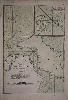
480 x 330 mm., early wash colour, with pasted over section containing new data on the north and east shores of Banca, in good condition.
A nice detailed chart of the coast of south east coast of Sumatra or Indonesia with the Island of Banca (Bangka) offshore. The material collected for 'Le Neptune Oriental' was approved by the French Compagnie des Indes. D'Apres de Mannevillette was one of the first Hydrographers of France and an accomplished navigator. Born in Le Havre to a captain in the French West India Company he made a voyage to the Caribbean in 1726. He showed an early interest in navigation and was one of the first Frenchmen to use Hadley's quadrant and was later in life a friend of Dalrymple. Upon the atlas' publication it was highly commended by everyone. Updated at various times after initial publication in 1745 it was expanded considerably in 1775. The inset upper right features a 'Petit Plan du Detroit a l'Est de Banca'. NMM 203 no. 18; Shirley M.Apr 1c.