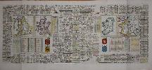
Item details: Nouvelle Carte pour Introduire a la Geographie et a la Genealogie des Rois d'Angleterre et d'Ecosse avec Diverses Remarques pour le Secours de la Chronologie et de l'Histoire
£ 295.00
CHATELAIN, Henri Abraham
Nouvelle Carte pour Introduire a la Geographie et a la Genealogie des Rois d'Angleterre et d'Ecosse avec Diverses Remarques pour le Secours de la Chronologie et de l'Histoire
Imprint: Amsterdam, 1708
380 x 940 mm., two sheets joined as one as issued, in full wash colour, in good condition.
A magnificent display of the Royal family tree of the British Isles. It features four maps of England, Scotland, Ireland and France whose cartography is derived from Guillaume de L'Isle. Each are accompanied by their respective coats of arms. The English throne begins at Egbert in 837 upper left, the Scottish with Fergus I in the year 3671. Keys list the remarkable battles in England and against France. It was published in the second volume of the encyclopaedic atlas by Henri Abraham Chatelain (1684-1743) entitled 'Atlas Historique ou Nouvelle Introduction a l'Histoire, a la Chronologie & a la Geographie'. It was issued from 1705 to 1720 in 7 volumes. Koeman II p. 33; Phillips 579; Shirley 'Atlases in the BL' T.Chat-1a; not in Shirley British Isles; Van Waning 'Chatelain's Atlas Historique' in IMCoS Journal 120 pp. 7-15.