390 x 500 mm., early outline colour and in good condition.
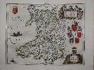
Willem Blaeu established the firm in 1599 as instrument and globe makers. His first topographical atlas appeared in 1630 in one volume and was gradually expanded. By 1640 the 'Novus Atlas' by his Joan Blaeu (1598-1673) was in three volumes and contained just 4 British Isles maps. His chief rival, the Hondius-Jansson atlas contained 18 maps. Both joined a race to make their fourth volumes a complete atlas of the British Isles. Blaeu was first, publishing his magnificent work in 1645, one year before that of Janssons. The work of Blaeu set a standard of design, beauty and quality that arguably has never been surpassed. He went on to produce some of the highest quality atlases ever published. This attractive map of Wales bears an ornate title upper right which is held aloft by cherubs beneath which are the arms of Wales, Bangor, St. Assaph, St. Davids and Llandaf. Below that is the dedication to King Charles I surmounted by the Royal Arms. The map itself is largely derived from that of John Speed. It is one of the more beautiful maps of Wales. This is an early example from 1648 with German text. Booth (1977) no. 14; Koeman Bl47D; Roberts, Iolo & Menai Printed Maps of the whole of Wales 1573-1837 Part 1 in The Map Collector no. 68 pp. 34-9; Skelton 28 & 44; Van der Krogt, P. (Atlantes) 5500:2.