 |
£ 2950.00
|
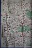
BACON, George Washington & Co. Ltd.
UndergrounD Map of London
Imprint: London, Roadway Timetables, Bookings & Publications Ltd,, [1932]
1010 x 1265 mm., colour printed lithographic map with blue edged border all the way around, with original folds in very good condition.
An unusual Quad-Royal poster of the London Underground in that it is laid onto a map of Central London at the scale of just under 7 inches to the mile. A note in the upper margin states 'Southgate extension of the Piccadilly Railway from Finsbury Park is now under construction ...', this helps in dating it as the Southgate station opened on 13 March 1933. In 1933 the iconic Underground design by Harry Beck was first published. In this the lines of the Underground are colour coded and do not detract from the street plan itself. Red circles denote the stations which are reminiscent of the earlier design introduced in 1908. Stingemore style lines are shown in different colours.It extends from Willesden Green top left, Drayton Park and Holloway Road top right, Oval lower right, Hammersmith and Walham Green lower left and London Bridge and the Oval stations lower right. The imprints in the lower margin read from left to right 'Drawn by G.W. Bacon & Co., Ltd.', centre 'Copyright map by Roadway Timetables, Bookings & Publications Ltd, Roadway Corner, Warwick Street, London W.1.', and to the right 'Litho - J.Weiner Ltd, London W.C.1.' David Leboff and Tim Demuth, 'No need to ask! : Early maps of London's Underground Railways', p. 76 has a full page illustration of this map (lacking the blue border), with details on the opposite page.
Stock number:9018.
|