 |
£ 2500.00
|
CHASSEREAU, Peter
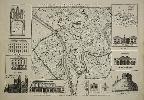
A Plan of the City of York Survey'd By Peter Chassereau/ Plan de la Ville et foubourgs de York. Capitale de le Comté du meme Nom levé par le Sr. P: Chassereau & Publié par Rocque a Charing Cross 1750
Imprint: London, John Rocque, 1750
450 x 690 mm., in very good condition printed on excellent thick paper.
One of the best large and detailed copper plate engraved plans of York, published by John Rocque in 1750 from a survey by Peter Chassereau. Chassereau was one of many members of French Huguenot society who settled in London. He became a surveyor and cartographer in Soho operating at “the Sign of the Golden Head, Berwick St.” One of his earliest works was a plan of the town and harbour of Havana for Thomas Bowles in 1739. One of the last works attributed to him is this plan of York for his fellow French Huguenot John Rocque.The city of York is depicted in great detail showing in the southern extreme the ‘Distillery’ on the west bank of the River Ouse and the Dyke leading to the Castle on the east side. The whole of the old town is displayed with the old walls and gates identified. Of great interest are the several fields still shown within the old walls. The map is surrounded by 10 inset views and one map upper right. The map shows the whole ‘County of Yokr’ misspelt with all the Roman roads. Notable structures in town occupy the other insets including the title upper left within an ecclesiastical architectural structure, the County Hospital, the City House, the west prospect of the Cathedral, a section of the Assembly Room, the Thursday Market and Pavement Crosses, the Prison, the Assembly Rooms and Cliffords Tower. Rocque’s imprint appears outside the neat line at the bottom of the plate. Jean Rocque (c.1704-62), to use his native name, was a Huguenot émigré who at an early age settled in England. By 1734 he was a surveyor, engraver and publisher. His work is renowned for its beauty as well as its accuracy and several important large scale maps were produced by him. Amongst his several productions are only four large scale county maps, the first was of Shropshire in 1752 followed by Middlesex, 1757, Berkshire 1761 and Surrey posthumously in c.1768. He was most prolific in producing several large-scale maps of towns and estates. This is a fine example of the first state of the map by John Rocque; a second state was published by his widow in 1766. For a detailed biography of John Rocque and a list of his works, see Map Forum Issue 3 online. Provenance: auction 2010; private English collection. Barron (1988); Butler (1989); Map Forum Issue 5, ‘The Works of John Rocque’ no. 57.
Stock number:9299.
|