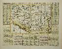
Item details: Carte Ancienne et Moderne des Differents Etats et Pais Situez au Long du Danube, pour Servir a l'Intelligence de l'Histoire
£ 150.00
CHATELAIN, Henri Abraham
Carte Ancienne et Moderne des Differents Etats et Pais Situez au Long du Danube, pour Servir a l'Intelligence de l'Histoire
Imprint: Amsterdam, c.1715
360 x 460 mm., in recent wash colour and good condition.
An attractive map of the Balkans region of south east Europe centred on the River Danube. It is surrounded by descriptive text in French. It was published in the second volume of the encyclopaedic atlas by Henri Abraham Chatelain (1684-1743) entitled 'Atlas Historique ou Nouvelle Introduction a l'Histoire, a la Chronologie & a la Geographie'. It was issued from 1705 to 1720 in 7 volumes. Koeman II p. 33; Phillips 579; Shirley 'Atlases in the BL' T.Chat-1a; Van Waning 'Chatelain's Atlas Historique' in IMCoS Journal 120 pp. 7-15.