Item details: Description du Nil… [and] Vue de la Ville du Grand Caire, et de ses Environs [and] Description des Piramides d'Egypte …
£ 125.00
CHATELAIN, Henri Abraham
Description du Nil… [and] Vue de la Ville du Grand Caire, et de ses Environs [and] Description des Piramides d'Egypte …
Imprint: Amsterdam, c.1715
375 x 490 mm., in recent wash colour and good condition.
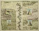
This plate contains a central map of the River Nile flanked either side by illustrations of the antiquities found in its valley. The illustrations are fully described in French. It was published in the sixth volume of the encyclopaedic atlas by Henri Abraham Chatelain (1684-1743) entitled 'Atlas Historique ou Nouvelle Introduction a l'Histoire, a la Chronologie & a la Geographie'. It was issued from 1705 to 1720 in 7 volumes. Koeman II p. 33; Phillips 579; Shirley 'Atlases in the BL' T.Chat-1a; Van Waning 'Chatelain's Atlas Historique' in IMCoS Journal 120 pp. 7-15.