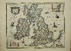
Item details: Magnae Britanniae et Hiberniae Tabula
£ 650.00
BLAEU, Willem
Magnae Britanniae et Hiberniae Tabula
Imprint: Amsterdam, 1648
470 x 555 mm., in fine early outline colour and good condition.
A beautifully engraved map of the British Isles from the renowned Willem Blaeu. It features a great deal of detail and yet manages not to feel 'heavy' as did earlier Dutch material. It includes an inset map of the Orkney Isles top right. The title is set in a handsome cartouche upper left which along with those containing the inset map, scale of miles and imprint are all beautifully wash coloured. The map appeared in most of the Bleau atlases and specifically in the 'Atlas Novus' volume of England and Wales from 1645. This attractive example, with German text on the reverse appeared in the 1648 edition. Koeman Bl47D; Skelton 28 & 44; Van der Krogt, P. (Atlantes) 5750:2; Shirley 411.