 |
£ 495.00
|
CARY, John - CRUCHLEY, George Frederick
Cruchley’s County Atlas of England & Wales Shewing all the Railways & Stations with their names, also The Turnpike Roads and principal cross roads to all the cities, market and borough towns with the distance from town to town
Imprint: London, 1875
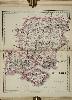
Quarto (235 x 155 mm.), full modern calf, spine with double gilt ruled compartments, black calf gilt title label, marbled endpapers. With title page, Index of maps, general map of England and Wales, 43 county maps on 44 plates (West Riding being on two plates) and both North and South Wales, 47 maps in total, all in early wash colour.
George Frederick Cruchley (1797-1880) had learned his trade with Aaron Arrowsmith and began to work for himself in 1823. His early days were concentrated on publishing maps of London but following the death of John Cary in 1834 he acquired much of the stock from the surviving heirs. Cruchley made lithographic transfers from the plates until he sold them all in 1877. Cruchleys main marketing tool was to add to the original plates details of the railways, postal, telegraph and other useful information. These plates were originally published by Cary as the 'New and Correct English Atlas', 1809. Although quite probably acquired at an earlier date Cruchley does not appear to have made use of them until 1863 when he published the 'County Atlas of England & Wales'. There were further dated editions of 1864 and 1875 with undated issues in-between. This is an example of the last dated edition of George Cruchleys 'County Atlas of England & Wales'. All editions are rare. Provenance: David Kingsley collection August 1989; private English collection. Beresiner pp. 93-5; Chubb 555; Nicholson (2003) G. F. Cruchley and Maps for the Million, in IMCoS Journal 93 pp. 21-38; Smith, George Frederick Cruchley, 1796-1880, in 'The Map Collector' no. 49 pp. 16-22.
Stock number:9662.
|