|
|
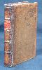
Imprint: London, Robert Sayer, 1787
Edition: 1 Binding: Hardback Small quarto (235 x 190 mm.), contemporary half calf, marbled paper boards, with gilt bands to spine along with red calf gilt title label, joints repaired. Engraved pictorial title, Preface and Index, 49 engraved maps including a newly introduced folding map of England and Wales by Thomas Jefferys, ALL IN EARLY WASH COLOUR, and a larger folding distance chart, a superb example.
VERY RARE EDITION. This small and attractive atlas was first published November 1748 in thirteen weekly parts by a consortium of nine publishers. No copy of this version survives and it seems likely that Jefferys and Kitchin took over the project at an early date. At some point before the publication of the second edition in 1751 alterations were made to some of the plates. During the issue of this 1751 edition plate numbers were added. The atlas proved popular, running to 7 editions, with various changes and additions, the last being in c.1796. Robert Sayer no doubt acquired his interest in the publication following the death of Thomas Jefferys in 1771. In 1776 Sayer with his partner at the time John Bennett first published a work entitled An English Atlas, this survives in just one known example (private English collection). This larger format work includes interleaved descriptive text with details of market towns and fairs below, all but the chart in original hand-colouring and all the same series of maps in an unfolded state.At some time prior to his death in 1787 Bennett left the partnership and possibly spurred by the immanent publication of John Carys New and Correct English Atlas Sayer published a new edition of this work. For this only one entirely new map of England and Wales by Jefferys is inserted. There is also a large folding triangular distance table engraved by Philip Luckombe (1730-1803). It is not present in the only known example of the first edition under this title of 1776 or in the Cambridge University Library example of this issue cited by Hodson. PROVENANCE: bookplates of Sir Andrew Warde Esq., Hooten Pagnell Hall, Yorkshire, inside front cover and on first free endpaper. Chubb (1927) no. 259; Hodson (1984-97) no. 214; refer Shirley (2004) T.Kit 2a (not in BL) Worms & Baynton-Williams (2011).
Stock number:8830.
|
|
|
Imprint: London, 1787-[c.94]
Edition: First Edition Binding: Hardback Inscription: Signed, Inscribed Or Annotated Small quarto (235 x 185 mm.), contemporary half calf, marbled paper boards, with gilt ruled bands, green calf gilt title label, light wear. With engraved pictorial title and Index, Preface and 49 engraved maps including a newly introduced folding map of England and Wales by Thomas Jefferys, all in fine early wash colour, each accompanied by a leaf of descriptive text, and a larger folding distance chart, internally in very good condition.
RARE EDITION. This small and attractive atlas was first published November 1748 in thirteen weekly parts by a consortium of nine publishers. No copy of this version survives and it seems likely that Thomas Jefferys and Thomas Kitchin took over the project at an early date. At some point before the publication of the second edition in 1751 alterations were made to some of the plates. During the issue of this 1751 edition plate numbers were added. The atlas proved popular, running to 7 editions, with various changes and additions. Hodson records it still being in the stock of Robert Wilkinson in 1825. Robert Sayer no doubt acquired his interest in the publication following the death of Thomas Jefferys in 1771. In 1776 Sayer with his partner at the time John Bennett first published a work entitled An English Atlas, this survives in just one known example (private English collection). This larger format work includes interleaved descriptive text with details of market towns and fairs below, all but the chart in original hand-colouring and all the same series of maps in an unfolded state.At some time prior to his death in 1787, Bennett left the partnership and possibly spurred by the immanent publication of John Caryâs New and Correct English Atlas, Sayer published a new edition of this work in 1787. An entirely new map of England and Wales by Jefferys replaces the earlier ones. There is also a large folding triangular distance table engraved by Philip Luckombe (1730-1803). It is not present in the only known example of the first edition under this title of 1776 or in the Cambridge University Library example of this issue cited by Hodson. Hodson records two further issues. In the first the folding chart by Luckombe bears a new imprint of Laurie and Whittle dated 1794 as here. The title remains unaltered and is still dated 1787 but the index is now corrected, Hertfordshire numbered '19' now precedes that of Herefordshire '20'. The three of islands at the end remain out of numerical order. Provenance: signature of J. B. Messenger on first free and paper; private English collection. Chubb (1927) no. 259; Hodson (1984-97) no. 216; refer Shirley (2004) T.Kit 2a (not in BL); Worms & Baynton-Williams (2011).
Stock number:10164.
|
|

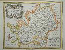
Imprint: London, 1769-[c.78]
305 x 375 mm., with small mark upper centre, and small hole at the double fold which is not unusual, otherwise in good condition.
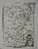
This map of Surrey was first issued in 'Kitchin's Pocket Atlass', 1769. Kitchin is one of the most famous of the eighteenth century county map makers, he contributed to several works. Here Kitchin displays some fresh thought with an atlas in which all the maps are drawn to the same scale, indeed the title points this out 'Drawn to One Scale. By which the true proportion they severally bear to each other may be easily ascertained.' The stock of plates for the unsuccessful atlas came in to the possession of Carington Bowles who re-issued them as 'Bowles's Pocket Atlas', c.1778. Here we have an example from the second edition. Hodson 259.
Stock number:7125.
|
|
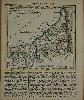
Imprint: London, 1769-[c.78]
305 x 375 mm., in good condition.
This map of Cornwall was first issued in 'Kitchin's Pocket Atlass', 1769. Kitchin is one of the most famous of the eighteenth century county map makers, he contributed to several works. Here Kitchin displays some fresh thought with an atlas in which all the maps are drawn to the same scale, indeed the title points this out 'Drawn to One Scale. By which the true proportion they severally bear to each other may be easily ascertained.' The stock of plates for the unsuccessful atlas came in to the possession of Carington Bowles who re-issued them as 'Bowles's Pocket Atlas', c.1778. Here we have an example from the second edition. Hodson 259; Quixley (1966) no. 31.
Stock number:9052.
|
|
|
Imprint: London, c.1774
Binding: Hardback Quarto (205 x 155 mm.), contemporary half calf, marbled paper boards, ornate gilt ruling, spine with raised bands, gilt ruled compartments and title, marbled endpapers. With double-page engraved title page, engraved Index and 57 engraved maps on forty-eight leaves with 14 folding, some trimmed close. All in approximate alphabetical order, engraved throughout, in good condition.
The mid-eighteenth century witnessed an increased market for travelling pocket atlases. Those of Herman Moll, Joseph Ellis and Thomas Kitchinâs Atlas Anglicanus were directed at that market. The latter atlas was still somewhat large and in 1769 Kitchin (1719-84) published a new and quite different atlas entitled Kitchinâs Pocket Atlass [sic]. It was smaller in format but did however include a new feature. All of the maps were drawn on the same scale, as the title claims âDrawn to One Scale. By which the true proportion they severally bear to each other may be easily ascertainedâ. It was an idea ahead of its time though, as sales proved poor and the number of surviving examples is an indication of this. Normally the engraving of county maps would use an earlier series as a source. This however was not practical as all the scales would have been different. How to achieve this was solved by using Kitchinâs own four-sheet map of England and Wales published in 1752. As was often the case at the time, languishing material in the market was often picked up by Carington Bowles (1724-93). For this Bowles edition, the title page was slightly reworded and each map now bears the title Bowlesâs Reduced Map of ⦠Also plate numbers have been added to each map. The dating of this edition has always challenged carto-bibliographers. It was originally catalogued as circa 1785 by Chubb in 1927, but this was revised by Hodson to circa 1778 in 1997. The evidence for this was its referral in the undated edition of Bowlesâs Post-Chaise Companion which can be dated between 1771 and 1782. In 2007, Bonhams, London, auctioned an example of Bowlesâs Pocket Atlas which bore a manuscript ownership inscriptions of a John Laroche, dated 1774. This is currently the most accurate dating we have. Chubb (1927) no. 256; Hodson (1984-97) no. 259; Shirley (2004) T.Kit 5b.
Stock number:10184.
|
|
Imprint: London, October 1758
185 x 260 mm., with folds as issued, in good condition.
From the 'London Magazine'. Folded as issued. Right hand margin slim. Thomas Kitchin was one of the most notable English cartographers of the eighteenth century. He was both an engraver and publisher of considerable reputation who was made Hydrographer to King George III. He worked with many of his contemporaries on various projects. His first notable work was the maps for the 'London Magazine' from 1747 to 1760. Jolly, D.C. (Brit Per) Lond-149.
Stock number:7612.
|
|
Imprint: London, 1748
185 x 225 mm., attractive modern outline colour. Folded as issued.
ex "London Magazine". Thomas Kitchin was one of the most notable English cartographers of the eighteenth century. He was both an engraver and publisher of considerable reputation who was made Hydrographer to King George III. He worked with many of his contemporaries on various projects. His first notable work was contributing the maps for the "London Magazine" from 1747 to 1760. This magazine included maps in response to John Hinton's rival "Universal Magazine" begun earlier in the same year. The map of Hertfordshire was published in the May 1748 issue. Hodson 33.1; Hodson 229.
Stock number:3509.
|
|
|
Imprint: London, John Bowles, at No. [space], in Cornhill; Carington Bowles, at No. 69, in St. Paul's Church-Yard; and Robert Sayer, at No. 53, in Fleet-street, 1767
Edition: First Edition Binding: Hardback Oblong quarto (195 x 260 mm.), recent half calf, marbled paper boards, with large red calf gilt title affixed to upper board. With typographic title page, 3 leaves of tables, one general map of England and Wales and 103 plates printed back to back as usual. Light crease to centre reflecting original limp binding of which the back is bound in, first two leaves with centrefold restoration, third leaf loose, otherwise in good condition.
Many earlier carto-bibliographers believed this work to be a later issue of John Senexâs Actual Survey of the Principal Roads first published in 1719. Recent examination has identified that it is actually a new series of plates. The 104 maps were engraved by Thomas Kitchin (1718-84), one of the most notable English cartographers of the eighteenth century. They are drawn very closely from those by Senex. He was both an engraver and publisher of considerable reputation who was made Hydrographer to King George III. He worked with many of his contemporaries on various projects, in this case John Bowles, Carington Bowles and Robert Sayer.Although dated 1767 there is some evidence that the work might have been available in 1766. It was not unusual for works published late in the year to bear the date of that following. In Robert Sayerâs New and Enlarged Catalogue for the Year 1766 he advertised it as âfitted up in a portable Manner for the Conveniency of Travellersâ. This is supported to some degree by the lack of an address for John Bowles in the imprint. Hodson records that John Bowles had to vacate the Black Horse in Cornhill because of a possible fire, âtill his house is rebuilt, or another procuredâ. The actual address in Cornhill in the imprint is blank. When he returned to the street he used the address âno. 13â, it is not known if this was the same building or not.It was priced at 7s. 6d. and as was common practice at the time, the first edition is found with two different imprints. In this case that of the Robert Sayer is found after that of the senior John Bowles and his son Carington. The other title is clearly printed at the same time with identical type setting, only the imprint of Sayerâs is placed first. The priority indicates through whose shop this example would have been sold. Provenance: Acquired 2017 from Clive A. Burden Ltd.; private English collection. Bennett (2007) p. 65; Chubb (1927) 141; ESTC T200473; Fordham (1924) p. 27 (erroneously identifying it as a later issue of the Senex); Hodson (1984-1997) p. 187; Shirley (2004) T.Kit 4a; Smith (1991a & b); Worms & Baytnon-Williams (2011).
Stock number:10179.
|
|
Imprint: London, 1754
240 x 170 mm., in good condition.
A map of Coromandel in the south east of India published in the London Magazine. Jolly Lon 88.
Stock number:8150.
|
|
Imprint: London, 1749
130 x 135 mm., in early outline colour with text below, in good condition.
A small and attractive map of Cornwall, it was first published in an atlas issued in thirteen weekly parts by a consortium of nine publishers, commencing in November 1748. No copy of this version survives, and it seems likely that Jefferys and Kitchin took over the project at an early date. At some point before the publication of the second edition in 1751 alterations were made to some of the plates as seen here. During the issue of the 1751 edition plate numbers were added therefore contents can vary in the states of the maps. This is an example before the addition of plate numbers. The atlas proved popular, running to six editions, with various changes and additions, the last being in 1787. Chubb 193; Hodson 210; Quixley (1966) 31; refer Shirley BL T.Kit 2a (not in BL).
Stock number:9258.
|
|
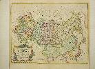
Imprint: London, 1748
340 x 440 mm., in fine later outline colour with wash to the ornate title cartouche.
A fine decorative map of the Russian Empire published by one of the pre-eminent map publishers in London at the time. It was published in the second volume of John Harris' 'Navigantium' published 1744-48. Shirley (2004) G.Harr 1a no. 27.
Stock number:9339.
|
|
Imprint: London, 1760
34 x 36.5cm. Modern colour, map has been cleaned. Folded map.
from an unidentified source.
Stock number:2797.
|
|
Imprint: London, 1751
Edition: 1 Small quarto (160 x 115 mm.), full contemporary calf, gilt embossed panels, with gilt bands to spine along with red calf gilt title label. Engraved throughout, pictorial title, one leaf containing preface and index, 50 engraved maps, ALL IN EARLY OUTLINE COLOUR with yellow wash borders, Rutland with tear in the map repaired, otherwise a good example.
This small and attractive atlas was first published November 1748 in thirteen weekly parts by a consortium of nine publishers. No copy of this version survives and it seems likely that Jefferys and Kitchin took over the project at an early date. At some point before the publication of the second edition in 1751 alterations were made to some of the plates. During the issue of this 1751 edition plate numbers were added therefore the states of the maps can vary. This example of the 1751 edition bears 4 maps still in their first state, 26 in their second state and 20 in the third state. The atlas proved popular, running to 6 editions, with various changes and additions, the last being in 1787. Provenance: Manuscript ownership inscription of George Evelyn March 15 1756; Powderham Castle, Library of the Earl of Devon. Chubb (1927) no. 193; Hodson (1984-97) no. 210; refer Shirley (2004) T.Kit 2a (not in BL).
Stock number:5245.
|
|
|
Imprint: London, 1751
Edition: 1 Binding: Hardback Small quarto (155 x 110 mm.), recent quarter calf, marbled paper boards, ornate blind ruling, spine with raised bands, blind ruled compartments with gilt date and title. Engraved throughout, pictorial title, one leaf containing preface and index, 50 engraved maps, Middlesex with light wash colour, the Isles of Scilly with centrefold split, otherwise a good example.
This small and attractive atlas was first published November 1748 in thirteen weekly parts by a consortium of nine publishers. No copy of this version survives and it seems likely that Thomas Jefferys and Thomas Kitchin took over the project at an early date. A first edition of the atlas was published in 1749. At some point before the publication of the second edition in 1751 alterations were made to some of the plates. During the issue of this 1751 edition plate numbers were added therefore the states of the maps can vary. This example of the edition bears 8 maps still unnumbered. Although dated 1751 on the title page the earliest known advertisement for the work appeared in the 'London Daily Advertiser' on 16 May 1752. It was offered for 5s. half-bound or 7s. 6d. bound and coloured. It could be bought at Thomas Jefferys shop as well as that of John Boydell in Cheapside and William Herbert at the Golden Globe on London Bridge. The title page itself also indicated that it was for sale in Dublin courtesy of George Faulkner and in Paris with George Louis Le Rouge. Jefferys would develop strong connections in Paris. Thomas Kitchin is not identified as a vendor, as at this point in his career he did not have any retail premises. The atlas proved popular, running to 6 editions, with various changes and additions. Provenance: acquired from the Brian Kentish catalogue of 2012, lot 31, for a private English collection. Chubb (1927) 193; Hodson (1984-97) 210; Pedley (1986) pp. 20-23; Worms & Baynton-Williams (2011).
Stock number:9779.
|
|
|
Imprint: London, 1751
Edition: First Edition Binding: Hardback Small quarto (195 x 160 mm.), side bound early quarter calf, contemporary paper boards, spine with blind ruled raised bands, light wear. Engraved throughout, pictorial title, one leaf containing preface and index, 50 engraved maps, in early outline colour with yellow wash borders, some light foxing, otherwise a good example.
A preferred side bound example of this small and attractive atlas which was first published from November 1748 in thirteen weekly parts by a consortium of nine publishers. No copy of this version survives and it seems likely that Thomas Jefferys and Thomas Kitchin took over the project at an early date. A first edition of the atlas was published in 1749. At some point before the publication of the second edition in 1751 alterations were made to some of the plates. During the issue of this 1751 edition plate numbers were added therefore the states of the maps can vary. This is an early example of the 1751 edition which bears 36 maps in their first state, 14 in their second state and none with plate numbers. Although dated 1751 on the title page the earliest known advertisement for the work appeared in the London Daily Advertiser on 16 May 1752. It was offered for 5s. half-bound or 7s. 6d. bound and coloured. It could be bought at Thomas Jefferyâs shop as well as that of John Boydell in Cheapside and William Herbert at the Golden Globe on London Bridge. The title page itself also indicated that it was for sale in Dublin courtesy of George Faulkner and in Paris with George Louis Le Rouge. Jefferyâs would develop strong connections in Paris. Thomas Kitchin is not identified as a vendor as at this point in his career he did not have any retail premises. The atlas proved popular, running to 6 editions, with various changes and additions, the last being in 1787. Chubb (1927) 193; Hodson (1984-97) 210; Pedley (1986) pp. 20-23; Worms & Baynton-Williams (2011).
Stock number:10163.
|
|
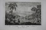
Imprint: Paris, 1827
220 x 280 mm., early sepia lithograph, in good condition.
A fine view of Bakhchisaray, the former capital of the Crimean Khanate, by Carl Kügelchen. The artist is named on the print however he may be the same Car-Ferdinand von Kügelgen listed in Benezit as being a landscape artist who was born in 1772 and travelled before settling in St. Petersbourg in 1803. He died in 1832. We have been unable to identify the work this is from. Not in Abbey Travel.
Stock number:6177.
|
|
Imprint: Paris?, 1827
240 x 285 mm., early sepia lithograph, in good condition.
A fine view of Sevastopol by Carl Kügelchen. The artist is named on the print however he may be the same Car-Ferdinand von Kügelgen listed in Benezit as being a landscape artist who was born in 1772 and travelled before settling in St. Petersburg in 1803. He died in 1832. We have been unable to identify the work this is from. Not in Abbey Travel.
Stock number:6176.
|
|
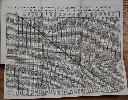
Imprint: London, 1798
Edition: First Edition 360 x 490 mm., in good condition.
This is a map representing the visit of the French Admiral and explorer, le Comte de La Pérouse to Korea and Japan in 1786. This is from the first English edition of La Perouse's voyage. Cortazzi, H. pl.62 (French ed).; Howes USIana L93; Sabin 38960; Shirley 'Atlases in the BL' G.LPR-2a curiously not listing this chart.
Stock number:7585.
|
|
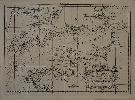
Imprint: London, 1798
225 x 310 mm., in good condition.
This is a view of the massacre of twelve members of the expedition of the French Admiral and explorer, le Comte de La Pérouse at Tatuila on the island of Maouna in Samoa. It was a great loss to the expedition, Robert de Lamanon was a botanist and physician. La Perouse's second in command Paul Antoine Fleuriot also lost his life. Jean-Francois de Galoup, Comte de La Perouse led a French scientific expedition to the Pacific in 1785-88. He was one of the most noted naval commanders and navigators in France and was selected by King Louis XVI to complete Captain James Cook's exploration of the western Pacific. In a rare moment of co-operation the British Admiralty furnished scientific equipment to measure variations in magnetic north and for determining longitude. Fortunately for us La Perouse was meticulous in sending copies of his detailed logs and surveying via other ships as well as overland. His last contact was in the spring of 1788 with a British ship in Botany Bay, Australia. The expedition was never heard from again. When the French Government realised that it had been lost they decided to publish an account as in many other ways it is regarded as one the greatest French voyages of exploration. It was not until 1827 that their fate was known. Howes USIana L93; Nordenskiold Collection v. 2; Phillips 688; Sabin 38960; Shirley 'Atlases in the BL' G.LPR-1a.
Stock number:8794.
|
|
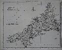
Imprint: London, 1798
Edition: First Edition 380 x 495 mm., in good condition.
This is a map representing the visit of the French Admiral and explorer, le Comte de La Pérouse to Korea in 1786. This is from the first English edition of La Perouse's voyage. A superb large-scale chart showing the track of La Perouse's expedition in the ships Boussole and Astrolabe. The route from Manila Bay to Taiwan (Formosa), to Korea through the Sea of Japan (named by La Perouse) to the Kuriles reaching southern Kamchatka on September 16, 1787. Jean-Francois de Galoup, Comte de La Perouse led a French scientific expedition to the Pacific in 1785-88. He was one of the most noted naval commanders and navigators in France and was selected by King Louis XVI to complete Captain James Cook's exploration of the western Pacific. In a rare moment of co-operation the British Admiralty furnished scientific equipment to measure variations in magnetic north and for determining longitude. Fortunately for us La Perouse was meticulous in sending copies of his detailed logs and surveying via other ships as well as overland. His last contact was in the spring of 1788 with a British ship in Botany Bay, Australia. The expedition was never heard from again. When the French Government realised that it had been lost they decided to publish an account as in many other ways it is regarded as one the greatest French voyages of exploration. It was not until 1827 that their fate was known. Howes USIana L93; Sabin 38960; Shirley 'Atlases in the BL' G.LPR-3a.
Stock number:6294.
|
|