|
|

Imprint: Paris, 1797
500 x 680 mm., two minor tears in the very large margins, well away from the image, otherwise in very good condition on lovely quality large margined paper.
This map features Easter island in the Pacific Ocean. From 'Atlas du Voyage de La Perouse'. Suarez, T. (Pacific) p.169, fig.164.
Stock number:8107.
|
|

Imprint: London, G. G. & J. Robinson, 1799
380 x 500 mm., slight discolouration along the centrefold otherwise in good condition.
This map features Easter island in the Pacific Ocean. From the London firm of Robinson's original French edition of the 'Atlas du Voyage de La Perouse' published in 1799. Hill p. 174; Suarez, T. (Pacific) p.169, fig.164.
Stock number:8108.
|
|
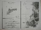
Imprint: London, G. G. & J. Robinson, 1799
380 x 500 mm., in good condition.
This is a map representing the visit of the French Admiral and explorer, le Comte de La Pérouse to Easter Island in 1786 in the Pacific Ocean. In three panels, with a view. From the London firm of Robinson's highly rated English translation of the original French edition of the 'Atlas du Voyage de La Perouse' published in 1797. Hill p. 174; Suarez, T. (Pacific) p.169, fig.164.
Stock number:8109.
|
|

Imprint: Paris, 1797
495 x 690 mm., mild water stain just visible upper part otherwise in good condition.
This is a map representing the visit of the French Admiral and explorer, le Comte de La Pérouse to Korea in 1786. A superb large-scale chart showing the track of La Perouse's expedition in the ships Boussole and Astrolabe. The route to him from Manila Bay to Taiwan (Formosa), to Korea through the Sea of Japan (named by La Perouse) to the Kuriles reaching southern Kamchatka on September 16, 1787. This is a map representing his visit to Korea in 1786. The tracks of La Perouse are shown. Jean-Francois de Galoup, Comte de La Perouse led a French scientific expedition to the Pacific in 1785-88. He was one of the most noted naval commanders and navigators in France and was selected by King Louis XVI to complete Captain James Cook's exploration of the western Pacific. In a rare moment of co-operation the British Admiralty furnished scientific equipment to measure variations in magnetic north and for determining longitude. Fortunately for us La Perouse was meticulous in sending copies of his detailed logs and surveying via other ships as well as overland. His last contact was in the spring of 1788 with a British ship in Botany Bay, Australia. The expedition was never heard from again. When the French Government realised that it had been lost they decided to publish an account as in many other ways it is regarded as one the greatest French voyages of exploration. It was not until 1827 that their fate was known. Howes USIana L93; Nordenskiold Collection v. 2 no. 133; Phillips 688; Sabin 38960; Shirley 'Atlases in the BL' G.LPR-1a.
Stock number:8124.
|
|
|
Imprint: Paris, 1797
270 x 410 mm., in good condition.
This is a view of the town of Buru in Indonesia recording the visit of the French Admiral and explorer, le Comte de La Pérouse. Jean-Francois de Galoup, Comte de La Perouse led a French scientific expedition to the Pacific in 1785-88. He was one of the most noted naval commanders and navigators in France and was selected by King Louis XVI to complete Captain James Cook's exploration of the western Pacific. In a rare moment of co-operation the British Admiralty furnished scientific equipment to measure variations in magnetic north and for determining longitude. Fortunately for us La Perouse was meticulous in sending copies of his detailed logs and surveying via other ships as well as overland. His last contact was in the spring of 1788 with a British ship in Botany Bay, Australia. The expedition was never heard from again. When the French Government realised that it had been lost they decided to publish an account as in many other ways it is regarded as one the greatest French voyages of exploration. It was not until 1827 that their fate was known. Howes USIana L93; Nordenskiold Collection v. 2; Phillips 688; Sabin 38960; Shirley 'Atlases in the BL' G.LPR-1a.
Stock number:8786.
|
|

Imprint: London, Edm. Bollifant, 1596
Edition: First Edition Octavo (185 x 145 mm.), full contemporary calf, corners repaired, rebacked with ornate gilt embossed and ribbed spine, red calf gilt title label. [10], 588, [6] pp. With single page map of 'Anglia Heptarchia' (slightly shaved at bottom with no significant loss) and large folding map of Kent (tipped in? and repaired at the folds), last leaf with a tear, A1 strengthened along the fore edge with no loss of text, some occasional light spotting otherwise in good condition.
William Lambarde (1536-1601) was a notable lawyer and antiquary of his day and part of the close circle of Queen Elizabeth I. One of his roles was as Keeper of the Records in the Tower. The first edition of the Perambulation of Kent was published in 1576 and was the earliest printed history of an English county. In it he refers to a Chart of the Shire (Hind I p. 224). Because of its vulnerability to invasion by the French the county of Kent had always been of special cartographic significance. The map here displays the beacon system to warn of danger to the coast. Lambardes protégé was Philip Symonson the superintendent of Rochester Bridge and later mayor of Rochester. In 1596 he would extend this work with a large two sheet map of the county. It coincided with the second edition of Lambardes work offered here. This is the second and best edition and is dedicated to Thomas Wotton. The DNB calls this work 'a model of arrangement and style'. Provenance: manuscript ownership inscription on verso of last printed page of '1689 John Beaban'; bookplates of Eustace Whereat Turner M.A.; Patrick Ashley Turner; and A. C. Burford; Marrin's Bookshop; private English collection. Burgess 'Kent' 5; Cox III, pp. 127-128; DNB; STC 15176; Upcott I, p. 350.
Stock number:7278.
|
|
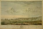
Imprint: Brompton, James Edwards, Brompton, Middlesex, 1817
420 x 600 mm., in fine early wash colour, with old folds, one tear upper right just in to the image, repaired, signs of one of the folds split although repaired professionally, otherwise in good condition.
A lovely early coloured copper plate view of Brighton, Sussex. By the mid-1700s English taste for prints was moving in to landscape views. One of the earliest proponents of this was a George Lambert (1700-65). However there is no evidence of any relation to our James Lambert. James (1725-88) was born in Willingdon, Sussex. He spent much of his life in Lewes and had London exhibitions between 1769 and 1778. In 1765 he painted this fine view of Brighton, and in the same year appeared an advert in the 'Lewes Journal'. first published in the same year. It stated 'Proposal for a print of the view of Brightelmston and the sea coast as far as the Isle of Wight from a drawing taken on the spot by James Lambert, Painter, Lewes. Conditions - the drawing shall be made very correct, and a print neatly engraved from it, two feet in length at least; the price, to subscribers, will be five shillings ...' As of 1995 the location of the original painting was unknown This is an example of the second state published by the firm of James Edwards of Brompton. It was engraved by the great talent Pierre Charles Canot (1710-77,) a Frenchman who practised etching and line engraving. He moved to England in 1740 where he spent the rest of his life. Although research seems to indicate that the Lambert family name died out, there is an interesting pencil notation on the verso by J. Lambert dated 1817. The field depicted was known as Belle Vue. The whole depicts the coastal town of Brighton as we know it with farmers engaged in the harvesting of crops. Cattle are seen pulling the hay collected by people cutting with scythes. Further in the distance are three wind mills. In the centre of the view standing on its own is Baker's Library with a rotunda near. Provenance: pencil notation on the verso 1817 Aug 22 Received 14.9 for this Number J. Edwards; private English collection since the 1980s. Mackenzie (1998) p. 117; Smith, Henry (1995) 'James Lambert. Every Picture tells a story', in 'Sussex Past and Present' August 1995.
Stock number:6182.
|
|
|
Imprint: Amsterdam, 1598-[1609]
90 x 130 mm., in good condition.
In 1598 Barent Langenes published in Middleburgh a miniature atlas to rival that of Abraham Ortelius. The maps were largely engraved by Jodocus Hondius and his brother-in-law Pieter van den Keere. This particular edition is from the "Hand-Boeck of Cort Begrijp der Caerten" published in 1609. Shirley "Atlases in the BL" T.Lan 1a; Van der Krogt, P. (Atlantes) 8700:341.
Stock number:4636.
|
|

Imprint: Amsterdam, 1609
8 x 12 cms., in good condition
In 1598 Barent Langenes published in Middleburgh a miniature atlas to rival that of Abraham Ortelius. The maps were largely engraved by Jodocus Hondius and his brother-in-law Pieter van den Keere. Shirley "Atlases in the BL" T.Lan 1a.
Stock number:4053.
|
|

Imprint: Antwerp, 1599-[1609]
90 x 120 mm., in good condition.
This fine early map of Madagascar is orientated with the east at the top. It is finely engraved by Benjamin Wright to replace the plate in Barent Langenes's original 'Caert-Thresoor' of 1598. This version was used in subsequent editions published by Claesz starting in 1599, this example is from the 1609 with Dutch text to the verso. Van der Krogt, P. (Atlantes) 8900:341B.
Stock number:6254.
|
|

Imprint: Antwerp, 1598-[1609]
90 x 120 mm., in good condition.
This fine early map of Saint Helena in the Atlantic Ocean with two small insets at the top. It is finely engraved by Benjamin Wright and was first published in the 'Caert-Thresoor' of 1598. This example is from the 1609 with Dutch text to the verso. Van der Krogt, P. (Atlantes).
Stock number:5726.
|
|

Imprint: London, 1817
17.5 x26.5 cm. Early wash colour.
ex 'Langley's New County Atlas of England and Wales'. Edward Langley (fl.1802-1835) was an established publisher and bookseller. He was also a printer and engraver. Joining forces with William Belch early in his career they would publish 'Langley's New County Atlas of England and Wales' in 1818. The maps are variously dated between 1816-18. Each has an attractive vignette adorning the map. This example of Hertforshire is in the first state, the second would bear the imprint of Joseph Phelps and was issued in 1820. Chubb 359.
Stock number:2571.
|
|

Imprint: London, 1818
175 x 255 mm. Early wash colour.
This attractive map is from 'Langley's New County Atlas of England and Wales'. Edward Langley (fl.1802-1835) was an established publisher and bookseller. He was also a printer and engraver. Joining forces with William Belch early in his career they would publish 'Langley's New County Atlas of England and Wales' in 1818. The maps are variously dated between 1816-18. Each has an attractive vignette adorning the map. This example of Norfolk is in the first state, the second would bear the imprint of Joseph Phelps and was issued in 1820. Chubb 359; Frostick Norfolk 84.1.
Stock number:2594.
|
|

Imprint: London, 1818-[20]
20 x 26 cms., early wash colour, in excellent condition
Edward Langley (fl.1802-1835) was an established publisher and bookseller. He was also a printer and engraver. Joining forces with William Belch early in his career they would publish Langley's New County Atlas of England and Wales in 1818. The maps are variously dated between 1816-18. Each has an attractive vignette adorning the map. This example of Hertfordshire is in the second state bearing the imprint of Joseph Phelps and was issued in the second edition of 1820. Hodson 77.2; Chubb 359.
Stock number:3515.
|
|

Imprint: London, 1817-[18]
200 x 260 mm., in lovely early wash colour, in good condition.
From 'Langley's New County Atlas of England and Wales'. Edward Langley (fl.1802-1835) was an established publisher and bookseller. He was also a printer and engraver. Joining forces with William Belch early in his career they would publish 'Langley's New County Atlas of England and Wales' in 1818. The maps are variously dated between 1816-18 this example being 1817. Each has an attractive vignette adorning the map, in this case St. Michaels Mount. This example of Cornwall is in the FIRST state. Chubb 359; Quixley (1966) no. 49.
Stock number:9072.
|
|

Imprint: London, 1817-[18]
200 x 265 mm., in lovely early wash colour, in good condition.
From 'Langley's New County Atlas of England and Wales'. Edward Langley (fl.1802-1835) was an established publisher and bookseller. He was also a printer and engraver. Joining forces with William Belch early in his career they would publish 'Langley's New County Atlas of England and Wales' in 1818. The maps are variously dated between 1816-18. This example is from an intermediate state with the date removed but before the imprint of Phelps was added. Each has an attractive vignette adorning the map, in this case a 'View of Epsom Races'. Chubb 360.
Stock number:9073.
|
|
|
Imprint: London, 1818
Edition: First Edition Binding: Hardback Oblong quarto (225 x 375 mm.), contemporary half calf, marbled paper boards with original publisher's paper title to upper cover, ornate gilt ruled (worn), rebacked preserving original spine, with gilt ruled compartments and title, light wear. With engraved title page (ink stain) and 53 maps all in early wash colour, consisting of one general map and 52 of the English and Welsh counties, otherwise in good condition.
THE FIRST EDITION. One of the most attractive English county atlases of the early nineteenth century with each map adorned by a vignette view and all in early wash colour. Worms and Baynton-Williams state that Edward Langley (fl.1802-1827) might have been born 7 June 1771, the son of Henry and Mary Langley of London. Apprenticed to a printer in 1785 he went on to work in Dorking, Surrey. We do know that in 1805 he went into partnership with William Belch (fl.1805-43) from 1805 until 1819. Belch was born in 1773 and from 1788 was apprenticed to William Darton. From 1795 he was in partnership with Darton on the occasional item. The maps in this atlas are variously dated between 1817 and 1818 and were first available separately with a slipcase. The earliest noted was that of Kent dated 1 November 1816, but this is only seen as a loose map. In this atlas there is no date on that of Kent, a date is also omitted from Surrey. The balance are all dated from 1 June 1817 (Essex and Hampshire) to 1 November 1818 found on the general map of England and Wales.Langley's New County Atlas of England and Wales was published late in 1818. Each has an attractive vignette adorning the map. The atlas sold for £2 12s 6d bound, according to the pasted label affixed to the upper board. A few counties are re-orientated to fit more neatly on the map. In the case of Cornwall, it is rotated clockwise by 22 degrees whilst still retaining a compass rose pointing incorrectly to the top of the map. As noted by Quixley, this is compounded by the longitude and latitude markers in the margins. The atlas is rare today and was clearly not that successful as in October 1819 Langley and Belch went into bankruptcy (London Gazette). Chubb (1927) 359; Quixley (2018) no. 70; Smith (1982); Tooleyâs Dictionary (1999-2004); Worms & Baynton-Williams (2011).
Stock number:10249.
|
|

Imprint: Paris, 1835
220 x 305 mm., an uncoloured aquatint on India paper, with minor water stain upper left corner away from the image, otherwise in good condition.
This view of Port Louis in Mauritius displays the harbour and is from Laplaceâs second voyage of circumnavigation which consolidated French interests in the Pacific entitled 'Voyage Autour du Monde ⦠La Favorite'. Dunmore states âthe importance of the expeditions of the Venus, the Artemise and the Heroine in laying the foundations for the subsequent sharing-out of Oceania should never be overlooked ...â Dunmore âFrench Exploration of the Pacificâ pp. 317-40; Judd & Lind âVoyages to Hawaii before 1860â 105; Sabin 38983.
Stock number:2807.
|
|

Imprint: Paris, 1835
220 x 305 mm., an uncoloured aquatint on India paper, with minor water stain upper left corner away from the image, otherwise in good condition.
This view of Port Louis in Mauritius is from Laplaceâs second voyage of circumnavigation which consolidated French interests in the Pacific entitled 'Voyage Autour du Monde ⦠La Favorite'. Dunmore states âthe importance of the expeditions of the Venus, the Artemise and the Heroine in laying the foundations for the subsequent sharing-out of Oceania should never be overlooked ...â Dunmore âFrench Exploration of the Pacificâ pp. 317-40; Judd & Lind âVoyages to Hawaii before 1860â 105; Sabin 38983.
Stock number:2810.
|
|
Imprint: Paris, 1835
220 x 305 mm., an uncoloured aquatint on India paper, with minor water stain upper left corner away from the image, otherwise in good condition.
This view of Malacca is from Laplaces second voyage of circumnavigation which consolidated French interests in the Pacific entitled 'Voyage Autour du Monde
La Favorite'. Dunmore states the importance of the expeditions of the Venus, the Artemise and the Heroine in laying the foundations for the subsequent sharing-out of Oceania should never be overlooked ... Dunmore French Exploration of the Pacific pp. 317-40; Judd & Lind Voyages to Hawaii before 1860 105; Sabin 38983.
Stock number:2809.
|
|