|
|
Imprint: Padua, 1572-[1713]
105 x 145 mm., light fold lower left, otherwise in good condition.
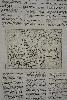
A map of northern Scotland first printed in Tommaso Porcacchi's 'L'Isole piu Famose del Mondo' published in Venice 1572. This issue is from Lasor a Varea's 'Universus Terrarum Orbis Scriptorum' published in 1713. His real name was Raffaello Savonarola and the two volume work was a compilation of plates and views from numerous earlier sources. Moir II p. 190 & 214 (not referring to this work); Phillips 3475; Shirley 'Atlases in the British Library' T.Las 1a.
Stock number:7806.
|
|
Imprint: London, 1821
495 x 315 mm., early outline colour, in good condition.
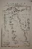
A fine map of ancient Egypt after the cartography of D'Anville. Robert Holmes Laurie succeeded to the business of Laurie and Whittle upon his father's death in 1812. In 1818 Whittle died leaving him in sole control.
Stock number:6273.
|
|
Imprint: London, Laurie & Whittle, 1786-[94]
640 x 930 mm., in good condition with very wide margins. Some light offset.
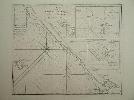
This chart is found in examples of Laurie and Whittle's "Complete East India Pilot". It shows the extreme south western shore of Sumatra leading to the Straits of Sunda. Inset plans of Cawoor Bay, Pulo Pisang and Little Fortune Island with Billimbing Bay are all by Captain Joseph Huddart. Joseph Huddart (1741-1816) was a Captain in the East India Company as a hydrographer and civil engineer. This chart was one of many of his work which are found in Laurie and Whittle's "Complete East India Pilot" which was first published in 1798. NMM 379 no. 146.
Stock number:4594.
|
|
|
Imprint: London, Robert Laurie and James Whittle, Map, Chart, and Print, Sellers, No. 53, Fleet-Street, 1810
Binding: Hardback Quarto (265 x 170 mm.), modern green cloth, gilt ruling top and bottom to the spine with gilt title, later endpapers. With typographic title page, Advertisement with Explanation on verso, Indexes, pp. 10, folding general map of England and Wales and 25 double page engraved maps all in early outline colour, complete with two blank endpapers, light browning and offsetting as often found, otherwise in good condition.
The firm of Laurie and Whittle relied heavily on the plates of Robert Sayer acquired following his death in 1794. Often thought of as mere publishers, Robert Laurie (1755-1836) was a noted craftsman. He was a talented mezzotint engraver who invented a method of mezzotint printing in colour, an achievement that won him an award from the Royal Society of Arts in 1776. In the early 1790s he entered the publishing business with James Whittle (1757-1818) as his partner. The acquisition of Sayerâs stock catapulted them into the major league. In 1806 they published a road book entitled the Laurie and Whittleâs New Travellerâs Companion which included 24 road maps. They were compiled by Nathaniel Coltman who, working for the Post Office was perfectly placed to produce them. Engraved by Joseph Bye, Edward Jones, Benjamin Smith and W. West, they covered territory as far as the Isle of Wight and Scotland. The format was a change from the past which up to now had largely followed the strip map format devised by John Ogilby in 1675. Coltman produces here, clear maps which cover larger areas for easier reference. The maps are strictly functional concentrating just on roads and distances, the earlier use of nearby features such as churches and hills are omitted. It was a success with a number of editions following and alterations were constantly made to the plates to bring them up-to-date. In 1810 two editions were published, a fourth and a fifth. For the first of these a 25th plate was engraved which extended the coverage of the west coast northwards into Scotland as far as Glasgow. For this edition the previous engraved title is replaced with a typographic one. Provenance: manuscript inscription of E. A. L. Fenner on front original free endpaper; label pasted inside front cover of 'Edwin Fenner, Chemist and Dentist, New Shoreham', he is listed in the 1881 census with that profession at 134 Clarence Place as born in 1834, Sydenham, Kent; private English collection. Beresiner (1983) pp. 136-9; Carroll (1996) Appendix no. 16; Chubb (1927) 343; Fordham (1924) p. 51.
Stock number:10223.
|
|
|
Imprint: London, 1832
Quarto (265 x 175 mm.), full contemporary limp red morocco, with locking flap (retainer missing) and marbled endpapers. With engraved title page as above, an Advertisement, Directions and Explanation, Index, Parliamentary Representation, pp. ii, 8, (4), folding general map of England and Wales and 25 double page engraved maps all in early outline colour, complete with blank endpapers, with some light offsetting, otherwise a good example.
The firm of Laurie and Whittle relied heavily on the plates of Robert Sayer which were acquired following his death in 1794. Often thought of as mere publishers Robert Laurie (1755-1836) was a noted craftsman. He was a talented mezzotint engraver who invented a method of mezzotint printing in colour, an achievement that won him an award from the Royal Society of Arts in 1776. In the early 1790s he entered the publishing business with James Whittle (1757-1818) as his partner. The acquisition of Sayerâs stock catapulted them into the major league. In 1806 they published a road book entitled the âLaurie and Whittleâs New Travellerâs Companionâ which included road maps. They were compiled by Nathaniel Coltman who working for the Post Office was perfectly placed to produce them. Engraved by Joseph Bye, Edward Jones, Benjamin Smith and W. West they covered territory as far as the Isle of Wight and Scotland. The format was a change from the past which up to now had largely followed the strip map format devised by John Ogilby in 1675. Coltman produces here clear maps which cover larger areas for easier reference. The maps are strictly functional concentrating just on roads and distances, the earlier use of nearby features such as churches and hills is omitted. It was a success with a number of editions following and alterations were constantly made to the plates to bring them up-to-date. In 1812 Robert Laurie retired and was replaced in the partnership by his son Richard Holmes Laurie and the firm changed its name to Whittle and Laurie. Then in 1818 James Whittle died and the firm became known as that of R. H. Laurie. The firm still exists today under the name Imray, Laurie, Norie & Wilson Ltd. This example from 1832 reflects those changes. A rare edition, Carroll notes that Fordham in 1924 cited in his personal copy of the work at the RGS that there was an edition in 1932, but Carroll could not report finding one. Provenance: with manuscript inscription of âGeo Stockwellâ on the title page. Beresiner (1983) pp. 136-9; Carroll (1996) Appendix no. 16; Fordham (1924) p. 51; Worms & Baynton-Williams (2011).
Stock number:10394.
|
|
|
Imprint: London, R. H. Laurie, No. 53, Fleet Street, 1838-[40]
Quarto (265 x 175 mm.), full contemporary limp red morocco, with locking flap (later?), rebacked, with pocket at the end and one later endpaper. With engraved title page, an Advertisement, Directions and Explanation leaf, Index, Parliamentary Representation, pp. ii, 8, (4), folding general map of England and Wales (with fold repair) and 25 double page engraved maps all in early outline colour, complete with blank endpapers. With some light offsetting, otherwise a good example.
The firm of Laurie and Whittle relied heavily on the plates of Robert Sayer which were acquired following his death in 1794. Often thought of as mere publishers Robert Laurie (1755-1836) was a noted craftsman. He was a talented mezzotint engraver who invented a method of mezzotint printing in colour, an achievement that won him an award from the Royal Society of Arts in 1776. In the early 1790s he entered the publishing business with James Whittle (1757-1818) as his partner. The acquisition of Sayerâs stock catapulted them into the major league. In 1806 they published a road book entitled the 'Laurie and Whittleâs New Travellerâs Companion' which included road maps. They were compiled by Nathaniel Coltman who, working for the Post Office was perfectly placed to produce them. Engraved by Joseph Bye, Edward Jones, Benjamin Smith and W. West they covered territory as far as the Isle of Wight and Scotland. The format was a change from the past which until first published had largely followed the strip map format devised by John Ogilby in 1675. Coltman produces here clear maps which cover larger areas for easier reference. The maps are strictly functional concentrating just on roads and distances, the earlier use of nearby features such as churches and hills is omitted. It was a success with a number of editions following and alterations were constantly made to the plates to bring them up-to-date. In 1812 Robert Laurie retired and was replaced in the partnership by his son Richard Holmes Laurie and the firm changed its name to Whittle and Laurie. Then in 1818 James Whittle died and the firm became known as that of R. H. Laurie. The firm still exists today under the name Imray, Laurie, Norie & Wilson Ltd. This example is the penultimate edition, the final issue being in 1846. The general map bears an imprint dated 1840. Carroll reports the same in another example. Found in the pocket at the end is a folding sheet in French with a table of routes in Germany. Provenance: with manuscript inscription of âGeo Stockwellâ on the title page. Beresiner (1983) pp. 136-9; Carroll (1996) Appendix no. 16; Fordham (1924) p. 51 (this edition not listed); Worms & Baynton-Williams (2011).
Stock number:10225.
|
|
Imprint: London, 1787
660 x 485 mm., in fine modern outline colour with light browning along the centre fold, otherwise fine.
A fine detailed chart of the waters around Batavia, or present day Jakarta in Indonesia. Jakarta can be seen lower right with the historically important port of Bantam further to the west. The Straits of Sunda are featured before the coast of Sumatra. A fascinating detail is the presence of Cracatoa in the Straits which was famously destroyed when it erupted in 1883. This chart is found in examples of Laurie and Whittle's 'Complete East India Pilot'. NMM 379 no. 154.
Stock number:4542.
|
|
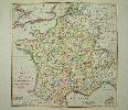
Imprint: London, 1795
55 x 56 cms., full early wash colour. In excellent condition
A fine decorative map of the whole of France as divided according to the National Assembly into eighty-three Departments in 1790. This map appeared in Laurie & Whittle's 'New and Elegant Imperial Sheet Atlas'. Shirley BL Atlases T.Lau 1a no. 18.
Stock number:3814.
|
|
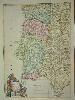
Imprint: London, 1794
59 x 41 cms., fabulous early wash colour.
A truly magnificent example of Laurie and Whittle's map of Portugal and the Algarve. A beautiful title cartouche. Shirley BL T.Lau-1a 20.
Stock number:3813.
|
|
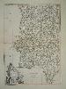
Imprint: London, 1794
590 x 410 mm., early outline colour, on fine paper and in good condition.
An example of Laurie and Whittle's map of Portugal and the Algarve. A beautiful title cartouche. Shirley BL T.Lau-1a 20.
Stock number:7017.
|
|
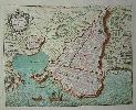
Imprint: Paris, c.1750
20 x 25 cms., in fine early wash colour
This plan of the town is from an unidentified mid-eighteenth century source. It is printed on a sheet of folio sized paper and has therefore large margins top and bottom
Stock number:3234.
|
|
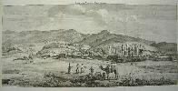
Imprint: Amsterdam, 1718
300 x 635 mm., good condition.
A fine panoramic view of the ruins of Persepolis, Persia. Cornelis Le Bruyn left the Netherlands on his second journey in 1701. He travelled first to Russia for a year before going on to Persia. He spent another year at Isfahan before a further 3 months at Persepolis recording the ruins and inscriptions. In 1705 he travelled on to the East Indies before returning home in 1708. Brunet III 911.
Stock number:5193.
|
|
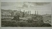
Imprint: Amsterdam, 1718
310 x 630 mm., in good condition.
A fine panoramic view of the ruins of Persepolis, Persia. Cornelis Le Bruyn left the Netherlands on his second journey in 1701. He travelled first to Russia for a year before going on to Persia. He spent another year at Isfahan before a further 3 months at Persepolis recording the ruins and inscriptions. In 1705 he travelled on to the East Indies before returning home in 1708. Brunet III 911.
Stock number:4842.
|
|
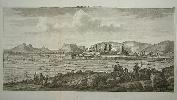
Imprint: Amsterdam, 1718
310 x 630 mm., good condition.
A fine panoramic view of the ruins of Persepolis, Persia. Cornelis Le Bruyn left the Netherlands on his second journey in 1701. He travelled first to Russia for a year before going on to Persia. He spent another year at Isfahan before a further 3 months at Persepolis recording the ruins and inscriptions. In 1705 he travelled on to the East Indies before returning home in 1708. Brunet III 911.
Stock number:4843.
|
|
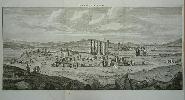
Imprint: Amsterdam, 1718
310 x 630 mm., good condition.
A fine panoramic view of the ruins of Persepolis, Persia. Cornelis Le Bruyn left the Netherlands on his second journey in 1701. He travelled first to Russia for a year before going on to Persia. He spent another year at Isfahan before a further 3 months at Persepolis recording the ruins and inscriptions. In 1705 he travelled on to the East Indies before returning home in 1708. Brunet III 911.
Stock number:5040.
|
|
Imprint: Jersey, c.1885
Binding: Hardback 390 x 645 mm., in early wash colour, lithograph backed on linen and folding into original green cloth binding, gilt title 'jersey' to upper cover, in good condition.
A fine large map of the island of Jersey with original colour delineating each of the island's parishes. All of the roads and lanes are also depicted along with churches, mills, rectories and the barracks. Distance mile stones are recorded along the routes. The key tells us that the, 'distances indicated by the various Mile-Stones, are taken from the Royal Square St. Helier's'. In 1864 the States of Jersey passed a law authorising the construction of the island's first railway. This standard gauge line was constructed, connecting St. Helier to St. Aubin, and the first train ran 25 October 1870. This railway was not a success and the company declared bankruptcy in 1874. The railway continued to operate but passed through a succession of proprietors until 1883.Meanwhile, the owner of a granite quarry near La Moye had petitioned to build a railway linking his quarry to St. Aubin. This law passed in June 1871 and the St Aubin & La Moye Railway commenced construction to the narrow gauge of 3 ft 6 in (1,067 mm). This line too, ran into financial problems and although construction trains ran on the section from La Moye to Pont Marquet, the company declared bankruptcy in 1878 before completion or opening to the public.In 1883 the Jersey Railway and the partially completed St Aubin & La Moye Railway were amalgamated into the Jersey Railways Company Limited. The St. Helier to St. Aubin line was relaid to 3 ft 6 in (1,067 mm) gauge and the railway re-opened to passengers on 15 March 1884, initially operating as two separate sections until the two lines were connected at St. Aubin in 1885 to form a complete railway. The first through service ran between St Helier and La Corbière on 5 August 1885. This railway too hit financial difficulties and in 1895 entered voluntary liquidation. In 1896 a new company, the Jersey Railways and Tramways Co. Ltd. was formed to take over the assets of the failed company. The railway was improved, with an extension to La Corbière Pavilion opening in 1899 and was successful up to the outbreak of the First World War.
Stock number:9131.
|
|
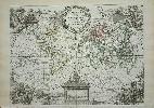
Imprint: Paris, 1748
220 x 300 mm., early outline colour. With small repair to tear in extreme lower right margin, not affecting the image.
A lovely double hemisphere world map with four ornate scenic cartouches. George Louis Le Rouge was a military engineer who took up cartography from about 1740. From the 'Atlas Nouveau Portatif a l'Usage des Militaires, et du Voyageur'.
Stock number:4581.
|
|
Imprint: Paris, 1767-[66]
Quarto (290 x 215 mm.), large paper copy, full contemporary calf, with early nineteenth century addition to enable large central gilt coats of arms, with gilt ribs to the spine, each compartment extensively decorated with gilt floral design, red calf gilt title label. With attractive engraved title page, key map and twelve double page engraved maps all with full early wash colour, engraved title in French and English Itineraraire de Toutes les Routes, Introduction (2), Table des Villes (4), Table des Routes (2), small general map of England and Wales, 101 engraved road strips with blank versos. Followed by Recueil des Villes Ports DAngleterre dated 1766, double page engraved table to the plan of London, double page engraved plan of London, engraved map of the Bouche de la Tamise and 16 engraved single page plans and views of British and Irish towns. Complete with contemporary endpapers. In very good condition.
George Louis Le Rouge was a military engineer who took up cartography from about 1740. This work is a French edition of 'An Actual Survey ... of the Principal Roads' by John Senex first published in London, 1719. This work consists of three parts all of which had been issued in earlier editions. Louis Charles Desnos (1725-1805) was a noted mapmaker, globe maker and publisher in Paris. Desnos was not the most successful of Parisian publishers, he went bankrupt in 1784. Despite being appointed globe maker to the King of Denmark he spent most of his life in Paris. He had a particular penchant for road books producing a number of France. The first part of this work consists of a general map of England and Wales in twelve sheets which is entitled 'Partie Meridionale de la Grande Bretagne
a Londres Chez T. Jefferis
1760'. The second was first published in 1759 as 'Les Routes DOgilby par lAngleterre' and comprises 101 plates of road strips preceded by an unaltered general map of England and Wales. Desnos was not known for his originality and here he just acquired the plates first issued by George Louis Le Rouge. Some minor alterations were made for instance in the first plate a note in French is added beneath. The engraved title page is reissued with alteration to the French title, it now reads 'Itineraire De Toutes Les Routes De LAngleterre
' It ends by removing the name of Le Rouge '
Ouvrage traduit de lAnglois. A Paris, Chez le Sr. Desnos
1766'. The English title is unaltered with just the imprint changed to 'For Desnos, Geographer, at the Globe St. James Street'. It is followed by the same presumably remaining preliminary leaves of text here rotated to enable viewing upright.The third and final part is entitled 'Recueil des Villes Ports DAngleterre Tire des Grands Plans de Rocque et du Portuland de lAngleterre du Sr. Belin' and is a fine work containing a series of town plans and views. The first is a double page plan of London preceded by a Table or key to it. This third part was first issued under the same title in 1759 by Le Rouge. The beautiful arms featuring a large central peacock are those of Guillaume Gabriel Pavee of Vendeuvre (1779-1870), born in Troye, a French politician and peer who served on the National Assembly for many years. His library was only dispersed at auction about ten years ago. Provenance: bearing the large ornate gilt embossed arms on the covers of Guillaume Gabriel Pavee of Vendeuvre; private English collection. Carroll (1996) Appendix no. 8; Chubb (1927) 143; Fordham (1924) p. 27 (not recognising them as a later edition of the Le Rouge); Phillips (1909-) 2918; Shirley (2004) T.Desn 3a.
Stock number:9172.
|
|
|
Imprint: Paris, Desnos Ingenieur Geographe pour les Globes et Spheres Rue St. Jacques, 1767-[66]
Binding: Hardback Quarto (285 x 205 mm.), large paper copy, contemporary quarter calf, with ornate embossed paper boards, with raised bands to the spine, each compartment with blind and gilt embossed decoration, gilt title, marbled endpapers. With attractive engraved title page, key map and twelve double page engraved maps all with full early wash colour, engraved title in French and English Itineraraire de Toutes les Routes, pp. Introduction (2), Table des Villes (4), Table des Routes (2), small general map of England and Wales, 101 engraved road strips with blank versos bound to face each other in pairs, engraved title Recueil des Villes Ports DAngleterre dated 1766, double page engraved table to the plan of London, double page engraved plan of London, engraved map of the Bouche de la Tamise and 16 engraved single page plans and views of British and Irish towns, with small ink stain to title, otherwise in good condition.
George Louis Le Rouge was a military engineer who took up cartography from about 1740. This work is a French edition of 'An Actual Survey ... of the Principal Roads' by John Senex first published in London, 1719. It consists of three parts, all of which had been issued in earlier editions. Louis Charles Desnos (1725-1805) was a noted mapmaker, globe maker and publisher in Paris. Desnos was not the most successful of Parisian publishers, he went bankrupt in 1784. Despite being appointed globe maker to the King of Denmark he spent most of his life in Paris. He had a particular penchant for road books producing a number of France. The first part of this work consists of a general map of England and Wales in twelve sheets which is entitled 'Partie Meridionale de la Grande Bretagne
a Londres Chez T. Jefferis
1760'. The second was first published in 1759 as 'Les Routes DOgilby par lAngleterre' and comprises 101 plates of road strips preceded by an unaltered general map of England and Wales. Desnos was not known for his originality and here he just acquired the plates first issued by George Louis Le Rouge. Some minor alterations were made, for instance in the first plate a note in French is added beneath. The engraved title page is reissued with alteration to the French title, it now reads 'Itineraire De Toutes Les Routes De LAngleterre
' It ends by removing the name of Le Rouge '
Ouvrage traduit de lAnglois. A Paris, Chez le Sr. Desnos
1766'. The English title is unaltered with just the imprint changed to 'For Desnos, Geographer, at the Globe St. James Street'. It is followed by the same presumably remaining preliminary leaves of text here rotated to enable viewing upright.The third and final part is entitled 'Recueil des Villes Ports DAngleterre Tire des Grands Plans de Rocque et du Portuland de lAngleterre du Sr. Belin' and is a fine work containing a series of town plans and views. The first is a double page plan of London, preceded by a Table or key to it. This third part was first issued under the same title in 1759 by Le Rouge. The beautiful arms featuring a large central peacock are those of Guillaume Gabriel Pavee of Vendeuvre (1779-1870), born in Troye, a French politician and peer who served on the National Assembly for many years. His library was only dispersed at auction about ten years ago. Provenance: acquired 2015. Carroll (1996) Appendix no. 8; Chubb (1927) 143; Fordham (1924) p. 27 (not recognising them as a later edition of the Le Rouge); Phillips (1909-) 2918; Shirley (2004) T.Desn 3a.
Stock number:9907.
|
|
|
Imprint: Paris, Chez le Sieur Desnos, 1767
Binding: Hardback Inscription: Signed, Inscribed Or Annotated Quarto (295 x 205 mm.), half modern green cloth, marbled paper boards, titles embossed on spine, later endpapers. With attractive engraved title page, general key map of England and Wales, 12 double page engraved maps to the key, all with full early wash colour, engraved title in French and English from Itineraraire de Toutes les Routes, introduction (2), Table des Villes (4), Table des Routes (2), engraved general map of England and Wales and 101 engraved road strips here with blank versos. Followed by Recueil des Villes Ports DâAngleterre dated 1766, double page engraved table to the plan of London, double page engraved plan of London, engraved map of the Bouche de la Tamise and 16 engraved single page plans and views of British and Irish towns. Complete with contemporary endpapers. Top right corner of title page repaired, not affecting plate area.
George Louis Le Rouge was a military engineer who took up cartography from about 1740. This work is a French edition of An Actual Survey ... of the Principal Roads by John Senex first published in London, 1719. First published in 1759 the French plates appear to have passed in to the hands of the publisher Louis Charles Desnos who like Le Rouge, offered them with dual language titles. Despite being appointed globe maker to the King of Denmark he spent most of his life in Paris. He had a particular penchant for road books producing a number of France. As the title of this work states it is in fact three books bound as one each with title page. The first is a general map of England and Wales, the second bears the road strips, the third entitled Recueil des Villes Ports DâAngleterre Tire des Grands Plans de Rocque et du Portuland de lâAngleterre du Sr. Belin is a fine work containing a series of town plans. The road strips are here updated with new additional notes in some cases. The introductory text leaves are rotated to enable viewing upright. Provenance: French ownership inscription with stamp nearby âMCâ dated 1791 on the title page; Professor E. G. R. Taylor with her pencil signature front flyleaf (author of carto-bibliographies); Birkbeck College (bookplate stamped sold by order); Sothebyâs 1990; private English Collection; acquired by Clive A. Burden Ltd. 1996; Adrian Almond Collection; Dominic Winter Auctions 19 June 2013 lot 62; private English collection. Carroll Appendix no. 8; Chubb 143; Fordham p. 27 (not recognising them as a later edition of the Le Rouge); Phillips 2918; Shirley BL T.Desn 3a.
Stock number:10170.
|
|