|
|

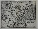
Imprint: Paris, Chez Le Rouge Jngr Georgraphe Du Roi Rue Des Grandes Augustins, 1777
760 x 1050 mm., two sheets joined as one, in fine early outline colour, printed on strong paper, light toning to joint of two sheets as often the case, otherwise in good condition.
In 1778 George Louis Le Rouge published an atlas of North America entitled Atlas Ameriquain Septentrional to rival that of Thomas Jefferys in London. It included numerous large scale maps including this one derived from Joshua Fry and Peter Jefferson magnificent map in four sheets first published c.1753. Although Le Rouge reduced the map from four sheets to two he managed to retain the original scale and faithfully copied the updated geography (Pritchard & Taliaferro). Colonel Joshua Fry (c.1700-54) was an American surveyor, mathematician and Commander of a Virginia Regiment. Peter Jefferson (d.1757) was a surveyor, planter and famously father of President Thomas Jefferson. Together they undertook several surveying missions for this map. With the outbreak of the French and Indian War there was a pressing need for accurate large-scale mapping of the American colonies. The Board of Trade in London issued instructions to the Virginia Governor to undertake the work and he turned to Fry and Jefferson. The finished map which is extremely rare in the early states was the first to map in detail the Appalachian and Allegheny Mountain ranges. The map is more usually seen in its later state and inclusion in Thomas Jefferys American Atlas first published in 1775. An uncommon map. Refer Cumming SE (1998) no. 281; Malone (1966) p. 18; Morrison (1983) fig. 42; refer Pritchard & Taliaferro (2002) no. 30; Shirley (2004) T.Ler 3a no. 18; Verner (1967) Imago Mundi 21 pp. 70-94; Wooldridge (2012) no. 110.
Stock number:8849.
|
|

Imprint: London, [c.1689-c.93]
Inscription: Signed, Inscribed Or Annotated 390 x 450 mm., early outline colour, even light toning throughout. There is no centrefold to the map indicating a separate issue however it is curiously folded horizontally two-thirds of the way down.
From an edition of Saxtons atlas by Philip Lea circa 1693, this plate did not appear in Christopher Saxtons original atlas. It is engraved by Francis Lamb and made its first appearance in the earlier 1689 edition by Philip Lea which survives in just three known examples. Here the map is found in its second state with the addition of roads, crosses, crowns and a mitre. Although the original Christopher Saxton copper plates came into the hands of Philip Lea sometime in or before 1689 the fate of two of the plates is unclear, Devon and Northumberland never reappear suggesting that they might have been lost in the Great Fire of London in 1666. They were replaced by plates engraved for Lea; that of Devon is signed by the engraver Francis Lamb. For further details of Leas issues of the Saxton atlas please see the entries for Saxton. Batten & Bennett no. 19 state 2; Skelton (1970) pp. 175 & 179.
Stock number:3839.
|
|

Imprint: London, 1693
415 x 535 mm., in early outline colour. With some light browning to the centre fold, otherwise in good condition.
In Philip Leas The Shires of England and Wales Described by Christopher Saxton, c.1693, three different maps may be found of Kent. The original Saxton plate which included the counties of Surrey and Sussex was used at first. This was replaced by the plate made available by John Ogilby in at least one known example; the Gardner copy. Finally and quite probably early on Lea commissioned his own production offered here in a later state. It is the presence of this map which helped carto-bibliographers confirm a date of 1693 on the atlas. It contains a plan of Canterbury, eight coats-of-arms and a dedication to John Tillotson as Archbishop of Canterbury a post he held from 1691-94. Provenance: private English collection. Burgess (2009) no. 26.i; Hodson (1984-97) I pp. 186-8; Skelton (1970) p. 179.
Stock number:7222.
|
|
|
Imprint: London, Samuel Leigh, 18, Strand, 1826
Edition: First Edition Binding: Hardback Sextodecimo (140 x 85 mm.), full contemporary green morocco, with gilt title to upper board, rebacked with gilt rules top and bottom, gilt title. With recent cloth to inside hinges. With frontispiece âTable of the Price of Postingâ, typographic title, Preface to the First edition, Literary opinions, Preface to the Second edition, engraved frontispiece to atlas, 55 county maps, pp. viii, (2), 476, and folding general map of England and Wales in early wash colour, in good condition.
In 1820 Samuel Leigh (fl.1812-d.31) published the New Picture of England and Wales. It included one general map only, but stated 'The proprietor has availed himself of the talents of Mr. Sidney Hall to project a series of correct county maps, the same size as this book, which may be had in a separate volume, with a complete Index of the towns, villages, etc.'. Leighâs New Pocket Atlas of England and Wales was published in the same year. It was a miniature county atlas which proved successful. Sidney Hall (1788?-1831) engraved the series of maps which were derived from those of John Cary. Hall was a prolific engraver of the period and according to Worms and Baynton-Williams 'was almost certainly the first engraver to use the new harder steel plates for map work, using plates manufactured by the Jacob Perkins process as early as 1821'. In 1825 Leigh published an accompanying New Pocket Road Book which can be found alone or bound with the atlas as here in its second edition. The extensive text provides fascinating descriptions of towns and places. Provenance: inscription of Charles Turner Lockward on title page; private English collection. Chubb (1927) 375; Fordham (1924) p. 58; Tooley's Dictionary (1999-2004); Worms & Baynton-Williams (2011).
Stock number:10257.
|
|

Imprint: Paris, c.1840
27.5 x 39.5 cms., early wash coloured lithograph on india paper
A nice birds eye view of the gardens and palace of Versailles
Stock number:3266.
|
|
Imprint: Paris, 1612
160 x 205 mm. The upper half of the fold had been split and is backed with only minor loss, left and right margins extended, lower margin with some neatline reinstated, otherwise a good example of an extremely rare map.
This very rare map of the present day Carolinas did not appear in the early editions of Lescarbot's 'Histoire de la Nouvelle France'. It was first published in the 1612 issue. It records the Huguenot inspired voyages which were commanded by Jean Ribaut and René Laudonière between 1562 and 1565. The latitudinal positions of coastal place names are more accurate, being almost 1 degree further south than on the Hondius, in almost exactly their true positions. 'La Caroline' is incorrectly shown on the north bank of the River May (St. John's River), and Charlefort is named at Port Royal. The Montagne de Palassi are described as bearing gold, silver and copper.' Burden 163; Church (1907) no. 356; Cumming (1938) pp. 476-92; Cumming (1962) no. 30 pp. 17-18; Cumming, Skelton & Quinn (1972) pp. 154-71, 181-92; Lowery (1912) no. 102; Schwartz & Ehrenberg (1980) pp. 64-7.
Stock number:2533.
|
|
|
Imprint: London, Letts, Son & Co. Limited, London Bridge, E. C., 1884
Binding: Hardback Folio (360 x 220 mm.), contemporary half calf, cloth boards gilt ruled, with gilt title and Royal Arms to upper board, spine with gilt and blind bands, gilt title, with Letts's adverts on endpapers, light wear. With title and Preface with Contents on the verso, pp. (4), 35, with 47 chromolithographic maps of England and Wales, with Omission's slip bound in before Index, some light foxing, otherwise in good condition.
The firm of Letts, Son and Co. are best remembered in English minds by their diaries first published in 1835 by John Letts (1772-1851), the founder of the firm in 1809. It was his son Thomas (1804-73) who upon taking over the business, rapidly expanded the diaries and general publishing. This series of maps began life as John and Charles Walker's 'British Atlas' in 1837. From about 1849 they were also published concurrently as lithographs in 'Hobson's Fox-Hunting Atlas' by William Colling Hobson. Charles Walker died in 1872 and John the following year. Further lithographic transfers were published as 'Letts's Popular County Atlas' in 1884 by the Letts firm. Thomas Letts had died in 1873 and by 1885 the firm was in liquidation. The rights to the diary were taken over by Cassell, Petter and Galpin who continued to publish using the Letts name. Lettsâs âPopular County Atlasâ consists of a general map, 42 maps of the English counties including the 3 Yorkshire Ridings, and maps of the four quarters of Wales. Each map is detailed and coloured. The Preface announces the detail enclosed including 'the recent earthquake in Essex'. The map itself with a 'Red Cross, thus X denotes recorded locations of Earthquake Shock, April 22nd, 1884. Size of the Cross represents comparative intensity.' Beresiner (1983) pp. 143-4. Carroll (1996) no. 105.N; Nicholson (2007); Tooley's Dictionary (1999-2004).
Stock number:10333.
|
|
|
Imprint: London, S. Lewis and Co., 13, Finsbury Place, South, 1842
Binding: Hardback Quarto (285 x 220 mm.), full contemporary green cloth, ornate blind decoration to boards, spine with blind ruling and decoration, gilt title, light wear to spine. With typographic title, with 57 maps comprising a folding general map of England and Wales, folding plan of London, 40 maps of the counties and Isle of Man, Jersey and Guernsey (Yorkshire folding), 12 maps of the Welsh Counties, of which a further 11 are smaller folding ones, all in early outline colour, in good condition.
Samuel Lewis (1782-1865) was the successful publisher of the Topographical Dictionary first published in 1831. The maps are often referred to as Creighton-Walkers. Robert Creighton was the draughtsman and Thomas Starling, John and Charles Walker were the engravers. Chubb omits listing the maps of Guernsey and Jersey present here. The large folding plan of London is of particular note. That of Hampshire is filed alphabetically under its title Southampton. The 'Topographical Dictionary' was issued in four volumes with later editions in 1842, 1844, 1845, 1848 and 1849. In later editions, the maps were often put together as a separate fifth volume or atlas as here. Lewis would publish similar works on Wales in 1833, Ireland in 1837 and Scotland in 1846. He brought a successful suit against Archibald Fullarton for plagiarism with the 'New and Comprehensive Gazetteer' issued 1833-37. Beresiner (1983) pp. 144-148; Carroll (1996) 93.v; not in Chubb (1927) refer 430; Worms & Baynton-Williams (2011).
Stock number:9948.
|
|
|
Imprint: London, W. Lewis, No. 21 Finch Lane, Cornhill, [1819]
Binding: Hardback Inscription: Signed, Inscribed Or Annotated Octavo (155 x 125 mm.), contemporary half red calf, ornate blind ruling, with marbled paper boards, spine with gilt panelled title. With general map of England and Wales, engraved title page, Preface dated 1819, Contents, List of Mail-Coaches etc., 40 maps of the counties, North and South Wales as called for, in all 43 maps, each with a page of descriptive text, Yorkshire folding, all in full contemporary wash colour. Some light foxing to the text, generally clean, otherwise a good example.
This fine little series of maps was first published by James Wallis (fl.1810-25) c.1812 as 'Wallis New Pocket Edition of the English Counties or Travellers Companion'. The maps are easily distinguished by the design of the title at the top of the map. They include a wealth of information with a key in the lower margin. A further edition was published c.1814 before they were used in two works by Patrick Martin, as the extremely rare 'Sportsmans Almanack' and the 'New Travellers Guide' surviving in just the one known example. By 1819 the work was in the hands of William Lewis (fl.1796-1838) who reissued it as 'Lewis's, New Traveller's Guide'. For the work a new title page was engraved with an attractive vignette of a coach and four with postillions. Although undated the Preface is signed 16 October 1819. It was first issued with the maps still bearing the imprint of Martin below. This was understandably altered quickly; this example bears the corrected imprints of Lewis at Finch Lane. There have been some alterations to many of the maps, roads have been re-engraved, the etching to the coast lines has been removed and many new placenames added. All of them are in lovely full early wash colour. The atlas was issued for many years unaltered and here the maps of Essex and Warwickshire, Worcestershire and South Wales all bear watermarks of Whatman 1821. Provenance: private English collection. Carroll (1996) 68; Chubb (1927) 364; Worms & Baynton-Williams (2011).
Stock number:9792.
|
|
|
Imprint: London, W. Lewis, No. 21 Finch Lane, Cornhill, [1819]
Binding: Hardback Inscription: Signed, Inscribed Or Annotated Octavo (150 x 115 mm.), contemporary half red calf, paper boards, publisher's gilt calf title label affixed to upper board, spine with blind ruled compartments. With general map of England and Wales, engraved title page, Preface dated 1819, Contents, List of Mail-Coaches etc., 40 maps of the counties, North and South Wales as called for, in all 43 maps, each with a page of descriptive text, Yorkshire folding, all in full contemporary wash colour, some even toning and light foxing to the text, Gloucestershire and Oxford text torn, Oxford map with some damage, otherwise a decent example.
This fine little series of maps was first published by James Wallis (fl.1810-25) c.1812 as Wallisâ New Pocket Edition of the English Counties or Travellerâs Companion. The maps are easily distinguished by the design of the title at the top of the map. They include a wealth of information with a key in the lower margin. A further edition was published c.1814 before they were used in two works by Patrick Martin, as the extremely rare Sportsmanâs Almanack and the New Travellers Guide which survives in just the one known example. By 1819 the work was in the hands of William Lewis (fl.1796-1838) who reissued it as Lewis's, New Traveller's Guide, reusing the title with its attractive vignette of a coach and four with postillions. Although undated the Preface is signed 16 October 1819. It was first issued with the maps still bearing the imprint of Martin below. This was understandably altered quickly. This however is an early issue with 26 maps retaining the Martin imprint, the remaining being blank. There have been some alterations to many of the maps, roads have been re-engraved, the etching to the coast lines has been removed and many new place-names added. According to the label pasted on the cover it was sold for â21sâ.It appears that this atlas was on the western front during the first world war. The date on the verso of the title page detailed below would indicate the Battle of Loos, the largest british attack of 1915, which took place between the 26-28 September, 1915. It was the first time the British used poison gas. Provenance: with several ownership inscriptions including in red ink inside front cover one in Co. Cork, Ireland; stamp of S. A. Boreham and by hand Mr B Canchett?, nr. Andover, Hants on front free endpaper; on final endpaper H. S. Farmer, Dublin; verso of title 'Brian C. Boreham 33820 ?, 1st. Section, Ammunition Column, 4 Brigade ... 7th Cavalry Brigade, British Expeditionary Force Sep 27th [19]15'; private English collection. Carroll (1996) 68; Chubb (1927) 364; Worms & Baynton-Williams (2011).
Stock number:10241.
|
|
|
Imprint: London, W. Lewis, No. 21 Finch Lane, Cornhill, [1819]-[32]
Binding: Hardback Inscription: Signed, Inscribed Or Annotated Octavo (150 x 115 mm.), contemporary half red calf, with paper boards, publisher's paper title label affixed to upper board, spine with gilt tooling top and bottom and gilt title. With general map of England and Wales, engraved title page, Preface dated 1819, Contents, List of Mail-Coaches etc., 40 maps of the counties, North and South Wales as called for, in all 43 maps, each with a page of descriptive text, Yorkshire folding, all in full contemporary wash colour, first front free endpaper with upper portion torn away, some light foxing to the text, otherwise a good example.
This fine little series of maps was first published by James Wallis (fl.1810-25) c.1812 as 'Wallisâ New Pocket Edition of the English Counties or Travellerâs Companion'. The maps are easily distinguished by the design of the title at the top of the map. They include a wealth of information with a key in the lower margin. A further edition was published c.1814 before they were used in two works by Patrick Martin, as the extremely rare 'Sportsmanâs Almanack and the New Travellers Guide' which survives in just the one known example. By 1819 the work was in the hands of William Lewis (fl.1796-1838) who reissued it as 'Lewis's New Traveller's Guide', reusing the title with its attractive vignette of a coach and four with postillions. Although undated the Preface is signed 16 October 1819. It was first issued with the maps still bearing the imprint of Martin below. This was understandably altered quickly; this example bears the corrected imprints of Lewis at Finch Lane. The atlas was on sale for many years, apparently unaltered. However, the maps of Gloucestershire and Somerset are printed on paper watermarked 1827 and that of Buckinghamshire may well be 1832. The maps of Essex and Warwickshire, Worcestershire and South Wales all bear watermarks of Whatman 1821.There have been some alterations to many of the maps, roads have been re-engraved, the etching to the coast lines has been removed and many new place-names added. According to the label pasted on the cover it was sold for â£1 1s.â, unchanged from its first issue.There have been some alterations to many of the maps, roads have been re-engraved, the etching to the coast lines has been removed and many new place-names added. All of them are in lovely full early wash colour. Provenance: ownership inscription inside upper cover dated 30 August 1832?; private English collection. Carroll (1996) 68; Chubb (1927) 364; Worms & Baynton-Williams (2011).
Stock number:10242.
|
|
|
Imprint: London, S. Lewis and Co., 87, Aldersgate-Street, 1835
Edition: First Edition Binding: Hardback Quarto (280 x 225 mm.), full contemporary green cloth, marbled effect to cloth, gilt title to spine. With typographic title, pp. (2), viii, 81, (1), (2), 5, (1), with 116 engraved maps numbered in roman all in early outline colour, comprising 42 of the English counties and 74 plates of the towns and boroughs, many more than one to a page, in good condition.
FIRST EDITION. For the third edition of Samuel Lewis' 'Topographical Dictionary' a new series of maps was added. This was to reflect the Reform Bill of 1832 and the changes to local government boundaries. The draughtsman was again Robert Creighton with the plates engraved by John and Charles Walker. The maps were derived from those of Robert K. Dawson produced for the Bill. They comprise those of counties along with all the boroughs and town plans. All are collected into the fifth volume, the only one offered here. They are bound by county, many of the town and borough plans are in detail and of towns of which very little at all would have been produced prior. Hampshire is bound under S for Southampton. Provenance: With inscription of 'John Bullen 3 New Inn Strand 16th January 1836 on first free endpaper. Carroll (1996) 104; Chubb (1927) 464.
Stock number:9947.
|
|
|
Imprint: London, S. Lewis and Co., 13, Finsbury Place, South, 1851
Binding: Hardback Quarto (325 x 255 mm.), contemporary green cloth boards with ornate blind decoration, rebacked with gilt spine, decorated and red calf gilt title label. With title page, Contents and six large folding maps, all in early outline colour, some areas of wear along folds, otherwise in good condition.
A neatly engraved large scale map of Scotland which in itself is undated. It is drawn on the large scale of 5 miles to the inch by F. A Carrington and G. W. Carrington and engraved by I. Dower and T. Harwood. the title takes up nearly all of the first sheet. In the lower left hand corner is a large vignette view of Melrose Abbey. The latest railways are laid down long with is an explanation. The whole set within a 'piano key' frame. The maps are unusually large and fresh with bright colouring. Samuel Lewis (1782-1865) was a publisher whose early life is little known. He published 'A Topographical Dictionary of England' in 1831 which was followed by Wales in 1833 and Ireland in 1837. This map was first published in 1846. Tooley's Dictionary; Worms & Baynton-Williams (2011).
Stock number:9819.
|
|
|
Imprint: London, S. Lewis and Co., 87, Aldersgate-Street, 1834
Binding: Hardback Quarto, 2 volumes (325 x 250 mm. each), later half calf, cloth boards, blind ruled, spine with double gilt ruled compartments with gilt title and volume details, recent endpapers preserving the original. With typographic title pages to both volumes, Preface, List of Subscribers, unpaginated, with 13 engraved maps including folding general map of Wales and 12 maps of the counties, a good example.
Samuel Lewis (1782-1865) was the successful publisher of the Topographical Dictionary of England first published in 1831. It was expanded in 1833 with this work on Wales, Ireland in 1837 and Scotland in 1846. The maps are often referred to as Creighton-Walkers. Robert Creighton was the draughtsman and Thomas Starling, John and Charles Walker were the engravers. Lewis brought a successful suit against Archibald Fullarton for plagiarism with the 'New and Comprehensive Gazetteer' issued 1833-37. Provenance: with manuscript ownership notations of 'W. G. Edmonds 1836' and 'Thomas Lucas left him by his affectionate Uncle. 1837'; unidentified bookplate inside cover; invoice of Tom Lloyd-Roberts, Mold, Flintshire, in 1972, loosely inserted. Beresiner (1983) pp. 144-148; Booth (1977) pp. 114-5; Carroll (1996) 93; Chubb (1927) 447; Worms & Baynton-Williams (2011).
Stock number:9965.
|
|
Imprint: Rome, Michele Tramezzino, 1558
400 x 545 mm., with extended margins as usual, very slight loss or neatline upper right side, otherwise in good condition.
"During the middle of the sixteenth century in Italy many map dealers and publishers started to bind together to order collections of various separately issued maps. This preserved much of the fine early material produced that would otherwise have been lost through the years. The two main sources of printed maps were Rome and Venice" (Burden). This superb early depiction of the British Isles is derived from the two-sheet one by George Lily (c.1510-59) printed in Rome in 1546. It is the first separately published map of the British Isles and recognised as the first modern map of the region. Its sources were numerous with many up-to-date, the big improvement was in the depiction of Scotland. Lily was a son of the famous grammarian, or linguist, William Lily and was under the patronage of Reginald Pole, with whom he returned from Italy in 1556. He was a noted historian and Catholic exile in Rome. Unfortunately that map is of remarkable rarity with just 15 examples currently recorded.Of the original highly influential map there were more than a dozen later derivatives. In 1549 two woodcut maps were published in Antwerp both of which survive in just one known example. Similarly one by Matteo Pagano in Venice also a woodcut is known in just one example. The first copper plate version was published in Rome in 1556 which is unsigned and bears the newly formed Jesuit Society insignia 'IHS' lower right by which it is usually known. "Of the Tramezzino family, Francesco worked in Rome and his brother Michele in Venice" (Burden). The latter (d.1579), who is the publisher of this map, employed Sebastian de Re to engrave this version. A simple title in a scroll appears upper right, below is a large textual cartouche bearing the imprint and date. Below this the scale of miles is present. Degrees of longitude and latitude are marked and all four cardinals are named. All Cathedral cities are noted as before. Two later states of the plate exist both surviving in one known example. Provenance: private English collection since circa 1981. Burden (1996-2007) refer no. 22; Karrow (1993) p. 270; Lynam (1934); Shirley (1991) no. 63; Taylor (1968) I p. 16; Tooley (1939) no. 271; Tooley (1999-2004).
Stock number:8957.
|
|
|
Imprint: Publish'd for Lindley & Crosley. No. 10 Surrey Place Kent Road, 1793
815 x 1120 mm., two sheets, full early wash colour, dissected and laid on contemporary linen, with original marbled paper slipcase, worn.
RARE LARGE-SCALE MAP OF SURREY. This is the fourth and last map of the county illustrated on a large scale of at least one inch to a mile before the Ordnance Survey. It was undertaken by Joseph Lindley (1756-1808) and William Crosley who fortunately for us, were one of the few who left their working notes on its production in a published memoir. Lindley worked in the Time Department at Greenwich and rose to become Head of the Department. His observational skills meant that he was sent to Paris with William Roy (1726-90) to help with the triangulation between Paris and London. It was Royâs measurement of the Hounslow Heath base line in 1784, shown on the map, which formed the basis of the London-Paris triangulation.After receiving permission from Roy to use his five measurements within Surrey, he proceeded to survey the remainder of the county drawing on 85 stations or high points. Lindley then sought the partnership of the draughtsman William Crosley (d.1794). An experienced Estate Surveyor who also worked considerably on the Rochdale Canal. Crosley undertook the topographical survey. The survey was completed in 1790 and a study of the orthography followed. This was a check on the spelling of placenames. The finished work was then sent to Benjamin Baker (1766-1841), the engraver at Islington.A first undated state was issued in c.1792 of which according to Rodgers only one example survives, in the British Library. A second state, quite likely first published, was issued dated as here 15 April 1793. The map includes not only the whole county but rudimentary outlines of the suburbs of London north of the River Thames. This also enables the map to record the Hounslow Heath base line and the parallel of latitude of the Royal Observatory Greenwich.All the usual features are identified. A couple of unusual features are the inclusion of windmills in visual form and all milestones on the roads are noted with small round circles. The whole is finished with a fine architectural title cartouche and in full early wash colour. The project was not a success, hence the mapâs rarity. Harley (1965) p. 63; Rodgers (1972) 439; this edition not in Sharp (1929); Worms & Baynton-Williams (2011).
Stock number:10345.
|
|
|
Imprint: London, By [John Windet for] Iohn Wolfe printer to ye Honorable Cittie of London, [1598], 1598
Edition: First Edition Binding: Hardback Folio (290 x 190 mm.), full contemporary calf, blind panelled with ornate central blind feature to both boards, spine with raised bands, blind ruled, with later ties?, some minor repair to top and bottom of the spine. With title page laid down, complete with the exception of all folding plates, the portrait of Linschoten and the title to the third book, those in the text and other titles are all present, some light waterstaining, otherwise in good condition.
The first English edition, translated from the original 1596 Dutch. Lacking the folding plates as above. For those more interested in the text and unwilling to pay the considerable amount extra to obtain a complete copy, this is a good example. It contains smaller maps of Sumatra, Java Major, Saint Helena, Congo and Spain. The work 'Contains all the knowledge and learning related to the East and West Indies and navigations to those parts that was available at the end of the sixteenth century. It was held in such high esteem that for nearly a century a copy was given to each ship sailing to India' (Hill). Provenance: early manucript incription on the title of 'Hen. Ware'. Borba de Moraes I p. 488; Church 321; ESTC S111823; European Americana 598/57; Hill 1025; Sabin 41374.
Stock number:9984.
|
|
|
Imprint: London, c.1795
Binding: Hardback Quarto (325 x 215 mm.), modern quarter calf by Temple Bindery, marbled paper boards, gilt ruled, spine with raised bands, gilt ruled compartments, black calf gilt title label, uncut. With original publisher's typographic 'title' and index loosely inserted, 40 engraved maps of the English counties, old liquid stain to first and final few maps lower corner, otherwise in good condition.
The Political Magazine began publishing in January 1780 at the hands of John Bew, bookseller and publisher of 29 Paternoster Row, London. From the beginning, Bew was keen to continue the tradition of eighteenth century Magazines of including maps. As an engraver, he employed John Lodge ((fl.1755-96) who had previously worked for the Gentlemanâs Magazine. In April 1782, a map of Ireland was published, one of Scotland in October 1784 and finally England and Wales in November 1785. John Murray (1737-93) joined Bew in partnership in February 1785 and from April of that year was in sole control. January 1787 saw the publication of Middlesex, followed by the Isle of Wight and Kent by May. By then a plan had clearly formulated to publish a full series of the county maps as from the following issue of June 1787 the county maps were issued in alphabetical order virtually monthly. In October 1789 Robert Butters (fl.1772-1809) of Fleet Street took control and continued the work with the publication of Oxford through completion in December 1790 with that of Yorkshire. It was to be the very last issue of the work.Shortly after at an unknown date the Atlas of Great Britain and Ireland was published. This collection of maps draws on all those issued in the Political Magazine except for those of the Isle of Wight and Isle of Man. The imprints of the Political Magazine and of the engraver Lodge are removed from the plates entirely. The title and contents label found pasted to the upper cover of some examples also bears no name, here it is retained loose. So, who was the publisher or issuer of this work? It is usual that the plates would have been owned by the publisher of the Magazine, in this case Butters, unless the assets needed to be sold. Butters went on to publish the extremely rare Atlas of England in 1803. But why would he wish to remove the reference to the Political Magazine which he had owned. Perhaps it had acquired a poor reputation? If Lodge owned the plates, he would not remove his imprints, and it is under Lodge that this work is usually listed for the lack of an alternative. Pembroke College, Oxford own an atlas compiled by Cluer Dicey with several of the county maps appearing in the first state. At first, I thought this might provide useful evidence, but it appears that they are later additions pasted on the verso of the maps issued at an earlier date. Based on a lack of an alternative it would seem likely that the plates were sold to an unknown third party who either wished to remain anonymous or never intended to publish them as an atlas. They were more than likely an acquirer of loose copper plates and sold prints and maps separately. An attribution of c.1795 to John Lodge therefore remains the best judgement available.There is no date, although Fordham recorded an example with a watermark date of 1795 present. An examination of this example finds no dated watermarks. A rare work, research has only located examples in the British Library, Bodleian Library, Oxford, Cambridge University Library, Whitaker Library, Leeds and the National Library of Scotland. Carroll (1996) 51; Chubb (1927) 249; Hodson (1984-97) p. 70; Jolly (1990) I pp. 145-72; Shirley (2004) T.Lod 1a; Worms & Baynton-Williams (2011).
Stock number:10211.
|
|

Imprint: London, 1788
29 x 32.5 cm. Uncoloured. Slightly faint down left hand side of map.
This map is one of a number first published in 'The Political Magazine' between 1782 and 1790, all carry the name of the engraver, John Lodge. When re-issued in atlas form the name was removed as in this example. Chubb 250.
Stock number:2592.
|
|

Imprint: London, 1790
265 x 330 mm., in good condition.
This map of the county of Surrey is one of a series first published in 'The Political Magazine' between 1782 and 1790, all carry the name of the engraver, John Lodge (fl.1755-96). First appearing in 1780 the 'Political Magazine' was published by John Bew. However from October 1789 it was in the hands of Robert Butters. It is the imprint of Butters which appears below the map along with the published date of 30 June 1790. The magazine's last issue was in December 1791. A rare map. Chubb 249; Jolly I POL 145; Worms & Baynton-Williams (2011).
Stock number:9063.
|
|