|
|
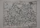
Imprint: London, 1790-[c.95]
265 x 330 mm., small margin tear upper right not affecting the image, repaired, otherwise in good condition.
This map of the county of Surrey was one of a series first published in 'The Political Magazine' between 1782 and 1790, all carried the name of the engraver, John Lodge (fl.1755-96). First appearing in 1780 the 'Political Magazine' was published by John Bew. However from October 1789 it was in the hands of Robert Butters. It is the imprint of Butters which appeared below the map along with the published date of 30 June 1790. The magazine's last issue was in December 1791 and ensuing ownership of the plates in not known. It was issued undated in the 'Atlas of Great Britain and Ireland' c.1795 by an unknown publisher. Both works are extremely rare. Chubb 250; Jolly I POL 145; Worms & Baynton-Williams (2011).
Stock number:9064.
|
|

Imprint: Oxford, 1675
Edition: First Edition 415 x 535 mm., cut close along the bottom just affecting the neatline, otherwise in good condition.
David Loggan's beautiful plan of the city of Oxford from BEN JONSON'S COPY OF THE SPEED ATLAS of 1631. Ben Jonson's (1572- 1637) library is celebrated as being the first of a major literary figure to survive in any great quantity. David McPherson in his 1974 work identifies 206 books, mostly in institutions. The Speed was his only atlas and was 'unquestionably the most luxurious and valuable book he is known to have owned' (Quaritch). The atlas was described as being rebound in the late seventeenth century at which point no doubt this plate by Loggan was inserted. It is an example of the first state of one of the earliest plans of the city as published in Loggan's magnificent 'Oxonia Illustrata' published in Oxford 1675. The book is generally considered one of the finest English engraved topographical works of the seventeenth century. The city is depicted with remarkable accuracy and bears a numbered key to churches, colleges and other major buildings.Loggan (1635-1700?) was born in Danzig and came to England about 1653. By 1665 he was living near Oxford and in 1669 was appointed engraver to the University. In the year the 'Oxonia' was published he married. The work often thought to have been printed at the Sheldonian was in fact run off at Leonard Lichfield's house in Holywell. "No records concerning Jonson's honorary degree from Cambridge or of the Oxford conferral survive, but in July 1619 Jonson was formally inducted into the Oxford degree, and, according to Anthony Wood, spent some time in residence at Christ Church at the invitation of his old friend Richard Corbett (Wood, Ath. Oxon., 1st edn, 1.518). Jonson later extended the circle of his Oxford friendships to include the learned group (of which Hobbes, Chillingworth, and Clarendon, were prominent members) which gathered at the house of Lucius Cary, Lord Falkland, at Great Tew." (ODNB).Provenance: Lord Egerton of Tatton Park, Cheshire; Sotheby's London 14 December 1953 lot 650 (the atlas) for £200 to Gledhill; Bernard Quaritch Ltd., c.1985. Griffiths 'The Print in Stuart Britain 1603-1689' pp. 201-03; McPherson, David (1974) 'Ben Jonson's Library and Marginalia: An Annotated Catalogue', in 'Studies in Philology, 71 no. 176; Shirley 'Atlases in the British Library', T.Spe 1f & 2b; Skelton (1970) 18; Upcott Oxford 34; Worms & Baynton-Williams (2011).
Stock number:8945.
|
|

Imprint: London, 1765
180 x 230 mm., modern wash colour, in good condition.
A charming little map focused on the old French Louisiana. This was due to the Treaty of Paris which ended the French and Indian War and granted Britain control westwards up to the Mississippi River. It illustrates the spread of the native Indian tribes across the middle of the continent and the position of several European settlements. Spanish territory in Texas is identified along with just at the right edge of the map Virginia. Engraved by Thomas Kitchin it appeared in the June 1765 issue of the 'London Magazine', one of the newspapers of the day. Jolly, D.C. (Brit Per) LOND-245.
Stock number:3994.
|
|

Imprint: London, 1765
180 x 230 mm., slight offsetting in the right margin not affecting the image.
A charming little map focused on the old French Louisiana. This was due to the Treaty of Paris which ended the French and Indian War and granted Britain control westwards up to the Mississippi River. It illustrates the spread of the native Indian tribes across the middle of the continent and the position of several European settlements. Spanish territory in Texas is identified along with just at the right edge of the map Virginia. Engraved by Thomas Kitchin it appeared in the June 1765 issue of the 'London Magazine', one of the newspapers of the day. Jolly, D.C. (Brit Per) LOND-245.
Stock number:4191.
|
|

Imprint: London, 1765
180 x 220 mm., in fine condition.
A fine dark impression of this map of the Florida peninsula and West Florida. The latter would later form parts of the states of Alabama and Mississippi. Florida is depicted at a time of great interest to the English as possession of it came after the Treaty of Paris only two years earlier when it was handed over by the Spanish. England was to hold it for just 20 years. It is depicted as an archipelago. Even in south Florida a number of toponyms are recognisable - 'Cayo Biscayne' and 'Boca de Ratones'. Jolly, D.C. (Brit Per) LOND-243; Seller & Van Ee #1620.
Stock number:3993.
|
|

Imprint: London, 1764
170 x 230 mm., modern wash colour, in fine condition.
This map falls in to the rich vain that is the De L'Isle - Buache De Fonte controversy. Their cartography was refuted by the important Muller map of 1754 which incorporated the new discoveries of Bering and Tschirikow. Its most recognisable feature is the alluded peninsula form of Alaska. This would be the model for the region until Cook updated the cartography. Despite this he still included the mythical Sea of the West. This version published in the 'London Magazine' in May 1764 was more probably derived from the Thomas Jefferys version of 1761. It shows the tracks of the explorers. Falk (1983) 1764.3; Jolly, D.C. (Brit Per) LOND-237; Kershaw 1121.
Stock number:3996.
|
|

Imprint: London, 1763
185 x 240 mm., in good condition.
A fine map engraved by Thomas Kitchin showing the Isle of Wight. It was published in the September 1763 issue of the 'London Magazine', a popular newspaper of the day. That issue recorded on p. 460 that 'We have obliged our readers this month with the annexed accurate and elegant Map of the Isle of Wight drawn from surveys, by Tho. Kitchin, geographer, which completes our sett of useful maps of England and Wales'. Jolly, D.C. (Brit Per) LOND-230.
Stock number:9709.
|
|
|
Imprint: New York, Drawn and Engrav'd for D. Longworth Map & Print Seller No.66 Nassau Street, c.1796-[c.98]
Inscription: Signed, Inscribed Or Annotated 410 x 555 mm., with light offsetting, good margins, uncut, with manuscript title to the verso, in good condition.
A PRESENTATION COPY OF THE FIRST FOLIO PLAN OF NEW YORK published after the American Revolution. It was presented by William Thornton, architect of the Capitol and Commissioner for the development of the city of Washington, to the Comte de Volney, author of the first book on the climate of the United States. New York post warThe City was occupied by the British throughout the American Revolution and was only officially handed over on 25 November 1783. The first US Congress met in 1785 in New York City at Federal Hall on Wall Street, number 1 in the legend of the map. In 1789, the City became the first capital of the United States under the new United States Constitution. The United States of Americas Bill of Rights was drafted and ratified there. George Washington was inaugurated at Federal Hall on 30 April 1789. New York City remained the capital but was found to be inadequate and was transferred to Philadelphia between 1790 and 1800 whilst the new capital of Washington was being constructed. New York continued to position itself for the remarkable growth of the nineteenth century. David LongworthOnly two post war plans were issued earlier than this one. A quarto sized plan of the city was published in The New-York Directory for 1789. A later reproduction of similar size was issued by William Duncan in his New-York Directory in 1791. This considerably larger one was published by David Longworth (d.1821). In 1796 he began publishing Longworths American Almanack, New-York Register, and City Directory. It would continue publishing under the auspices of his son Thomas through to the 1840s.The map is drawn by J.A. Del[ineated]. This is identified as John Anderson (d.1798), whose diaries survive in the New York Historical Society. He was an artist, lawyer and brother to Alexander Anderson the engraver. He was also a friend of Washington Irvings. The diary states in an entry on 21 April 1796 that he began to draw a plan of the city for Mr. Longworth. Quite why he turned to Anderson is not clear, no other cartographic work is known by him. On the 3 May he delivered the plan and charged him eight dollars. Longworth turned to the engraver Peter Rushton Maverick (1755-1811) to produce the map. Tooleys Dictionary describes him as a silversmith and portrait engraver and one of a family of engravers. The New York Daily Advertiser for 9 May 1796 announced A large plan of the city of New York, is now engraving for Longworths American Almanac and NEW-YORK DIRECTORY. Subscriptions for a few copies of said Plan separate from the Directory, price only four shillings, will be received by the Editor No. 66, Nassau Street. This slightly contradicts the title page of the Directory which states embellished with an accurate Map of the City. Certainly, no known example of any of the early editions includes an example of the map. Anderson died in the Yellow Fever epidemic of 1798.The PlanThis plan records the city at the beginning of this important period. A table of references on the left identifies 45 places. There are two additions here to the earliest known state. Number 44 is the Flag Staff at the old Battery constructed in 1790. The historic Battery itself was dismantled and is here replaced by Government House; a building intended as an executive house for President George Washington. Number 45 is Bunker Hill on Grand Street which has here been extended westwards. The Hill has been re-engraved and marks the sight of the popular but cruel sport of bull baiting. It was also a popular duelling ground. The area is now known as Little Italy. The area at the top of the map north of Grand Street is present day Soho. By the East River, Dover Street marks the present-day site of the Brooklyn Bridge. Further east the shoreline centred on Montgomery St. identifies the site of present-day Pier 36. Willets Wf. is named for the popular American Revolutionary figure and mayor of New York, Marinus Willett (1740-1830). North Street marks the beginning of the current numeration of streets to the north.Buttonwood AgreementThe Buttonwood Agreement took place purportedly under a Buttonwood Tree on 17 May 1792. It was an attempt to organize the trading of securities in New York. It was signed by 24 stockbrokers outside of 68 Wall Street. There were two main provisions to the agreement. Firstly, they the signatories, would only buy and sell from each other. Secondly that the commission was set at 0.25%. The following year they began conducting their business as in London, at a coffee house called Tontines. This is marked on the map as no. 38. It developed into what we now know of as the New York Stock Exchange. Known statesWheat & Brun identifies only works up to 1800 and lists two entries for this plan. Even then they could not identify any examples or even its dimensions. We now know of 5 different states of the map. Of all the issues only about a dozen examples are known in institutions. Of the first state only the New York Public Library and one recently sold by Boston Rare Maps are known. This is likely to be a proof state as it does not bear any imprint below. This therefore may well be the first published state known. An example of this issue is also found in the New York Public Library. Three later dated editions of 1803, 1804 and 1808 are known also.Comte de VolneyThis example comes from Constantin Francois de Chasseboeuf, Comte de Volney (1757-1820), who was a French philosopher and historian whose Ruins of Empires was mostly translated secretly by Thomas Jefferson. It was Jefferson who inducted him into the American Philosophical Society. On arrival in America in 1795 he was warmly received by President Washington who, like Thomas Jefferson, was an admirer of France. Their political rival John Adams however distrusted them. The French were becoming even more ruthless towards Americans at sea than had been the British no other country totally accepted the United States as a viable entity, and both Britain and France still believed they were entitled to most of North America. Many in both countries considered the American experiment would fail (Graye). Upon becoming President, John Adams suspicions about Volney increased although there is no evidence to support this. There are ten surviving letters between Thornton and Volney which relate their close friendship. Thornton aware of his position in Washington had to tread a careful line. They both shared similar enlightened ideals about universal education (Graye).Provenance: presented as part of a portfolio of maps by William Thornton to Comte Volney acquired 15 May 1984; Burden Collection. Boston Rare Maps; Graye, Michelle (2014) Thomas Jeffersons Washington Architect: William B. Thornton, Monticello West pp. 196-7; Stokes (1915-28) vol. V April 1803; Tooleys Dictionary; Wheat & Brun 391 & 395.
Stock number:9726.
|
|

Imprint: Augsburg, c.1760
500 x 570 mm., in fine early wash colour. Good condition. An excellent UNFOLDED example.
Tobias Conrad Lotter was an engraver active from the 1740s to his death in 1777. He acquired the business of his father in law Mattheus Seutter in the early 1760s. Later issue of map by Seutter. Imago Mundi 53 'Seutter, Probst and Lotter: An Eighteenth Century Map Publishing House in Germany' pp. 130-5; Shirley BL. T.Lott 1a.
Stock number:4673.
|
|

Imprint: London, 1803
Edition: First Edition 70 x 70 mm., with text below, in fine full early wash colour.
From the "New Pocket Atlas and Geography of England and Wales" by John Luffman (fl.1776-1820). He had a varied career being a publisher, engraver, goldsmith, author and geographer. This is his most noted work being distinctive in format and very desirable. This is an example of the second state which can also be found in the first edition of the atlas. Chubb 308.
Stock number:5805.
|
|

Imprint: London, 1803
Edition: First Edition 70 x 70 mm., with text below, in fine full early wash colour.
From the "New Pocket Atlas and Geography of England and Wales" by John Luffman (fl.1776-1820). He had a varied career being a publisher, engraver, goldsmith, author and geographer. This is his most noted work being distinctive in format and very desirable. This is an example of the second state which can also be found in the first edition of the atlas. Chubb 308.
Stock number:5804.
|
|

Imprint: London, Lackington, Allen & Co. Temple of the Muses Finsbury Square, 1803-[06]
Binding: Hardback Octavo (165 x 100 mm.), contemporary half red calf, marbled paper boards, gilt ruled, with gilt ruled compartments to the spine, original paper title label affixed to the upper board. With engraved title, Preface dated March 1803, half title 'England', 42 circular maps of the English counties, half title 'Wales', 12 maps of the Welsh counties, map of England and Wales, Index leaf, 54 roundel maps in total, each with typographic text below, in good condition.
John Luffman (1751-1821) had a varied career being a publisher, engraver, goldsmith, author and geographer. He also became bankrupt in 1793 but appears to have recovered. His earliest recorded work is the engraving of the road strips for Taylor and Skinner's 'Survey and Maps of the Roads of North Britain' in 1776. In 1779, he was the engraver of Prior's large scale map of Leicestershire and in 1781 he was the engraver of Armstrong's large scale map of Rutland. Later in his career he became a publisher in his own right specialising in smaller maps and atlases such as the Select Plans of the Ports and Harbours of the World (1800-1803). These curious circular engravings of the counties of England and Wales are his most noted work and accompanied a geographical text. A rare atlas that has always been desired by collectors. It was first published in 1803 by Luffman as a 'New Pocket Atlas and Geography of England and Wales'. A further issue was published in the same year, the maps in which are all in their second state, but by 1806 ownership had passed to the firm of Lackington, Allen & Co. This firm was founded in 1774 by James Lackington from Somerset as a shoemaker. From there he moved temporarily to Bristol where he first began buying books at market stalls. It is stated he was to ashamed to enter bookshops! A legacy of £10 enabled him to rent a shop in London from where he started selling both shoes and books. Soon he focused on the books and by 1803 their catalogue contained 800,000 books! Lackington retired in 1798 and died 1815. The firm finally closed when George Lackington retired in 1826. Refer Batten & Bennett (1996) 66; refer Carroll (1996) 59; Chubb (1927) 308; Worms & Baynton-Williams (2011).
Stock number:9191.
|
|
|
Imprint: London, Lackington, Allen & Co, 1803-[06]
Binding: Hardback Octavo (185 x 115 mm.), contemporary half red calf, marbled paper boards, gilt ruled, with original paper title label affixed to the upper board, later endpapers, worn, rebacked to style. With ornate engraved title, half title 'England', Preface dated March 1803, 42 circular maps of the English counties, half title 'Wales', 12 maps of the Welsh counties, all in FULL EARLY WASH COLOUR, a double page map of England and Wales in early outline colour, Index leaf, 54 early wash colour roundel maps in total, each with typographic text below, some light show through on a few maps to the versos, some offsetting to final map and Index, otherwise in good condition.
John Luffman (1751-1821) had a varied career being a publisher, engraver, goldsmith, author and geographer. He also became bankrupt in 1793 but appears to have recovered. His earliest recorded work is the engraving of the road strips for Taylor and Skinner's 'Survey and Maps of the Roads of North Britain' in 1776. In 1781 he was the engraver of Armstong's large scale map of Rutland. These curious circular engravings of the counties of England and Wales are his most noted work and accompanied a geographical text. A rare atlas that has always been desired by collectors. It was first published in 1803 by Luffman as a 'New Pocket Atlas and Geography of England and Wales'. A further issue was published in the same year, the maps in which are all in their second state, but by 1806 ownership had passed to the firm of Lackington Allen & Co. This firm was founded in 1774 by James Lackington from Somerset as a shoemaker. From there he moved temporarily to Bristol where he first began buying books at market stalls. It is stated he was to ashamed to enter bookshops! A legacy of £10 enabled him to rent a shop in London from where he started selling both shoes and books. Soon he focused on the books and by 1803 their catalogue contained 800,000 books! Lackington retired in 1798 and died 1815. The firm finally closed when George Lackington retired in 1826. Provenance: private English collection acquired 2018. Refer Batten & Bennett (1996) 66; refer Carroll (1996) 59; Chubb (1927) 308; Worms & Baynton-Williams (2011).
Stock number:9785.
|
|
|
Imprint: London, 1803
Edition: First Edition Binding: Hardback Octavo (170 x 105 mm.), in contemporary quarter paper boards with original paper title label, rebacked, uncut. With engraved title, Preface, England including a short key with attached paper label, 42 circular maps of the English counties, half title 'Wales', 12 maps of the Welsh counties, all in their FIRST STATE and each with original tissue, Index leaf, an Index map of England and Wales followed by an advert for 'New Works published by J. Luffman', plates 41 and 42 bound in opposing order, otherwise in good condition.
AN UNCUT EXAMPLE OF THE EXTREMELY RARE FIRST EDITION, FIRST STATE. No other example has been on the market since 2006. John Luffman (fl.1776-1820) had a varied career being a publisher, engraver, goldsmith, author and geographer. He was apprenticed to John Bayly in the Goldsmiths Company and made free in 1773. His earliest recorded work is the engraving some of the road strips for George Taylor and Andrew Skinnerâs Survey and Maps of the Roads of North Britain in 1776. In 1779, he was the engraver of John Priorâs large-scale map of Leicestershire and in 1781 did the same for Captain Andrew Armstrongâs large-scale map of Rutland. He visited Antigua in 1786-88 and published an account in 1789. By 1793 though, he became bankrupt but appears to have recovered. Later in his career he became a publisher in his own right specialising in smaller maps and atlases such as the Select Plans of the Ports and Harbours of the World (1800-1803).These curious circular engravings of the counties of England and Wales are his most noted work and accompanied a geographical text. A rare atlas that has always been desired by collectors. This first edition was published in 1803 by Luffman as a New Pocket Atlas and Geography of England and Wales. A further issue was issued later in the same year where the maps all appear in their second state. The difference can be found in the location of the plate numbers above the map. In the first issue they are some distance above the round borders nearer the plate edge and are often found cropped in binding. In the second issue they were re-engraved closer to the upper edge of the border. Each map contains the chief towns, roads and boundaries. No physical features are recorded at all. Pasted to the half title of this example is an attached paper label stating, 'Scotland and Ireland, to correspond with this work, will be published early in 1804'. No such work is known to have been published. Provenance: manuscript ownership inscription of R. J. Alser inside front cover; private English collection; Clive A. Burden Ltd. 1997; private English collection; Clive A. Burden Ltd. (2012) Catalogue IX item 63; private English collection. Refer Batten & Bennett (2008) no. 66; refer Carroll (1996) 59; Chubb (1927) 309; Worms & Baynton-Williams (2011).
Stock number:10220.
|
|
|
Imprint: London, 1803-[06]
Edition: First Edition Binding: Hardback Octavo (185 x 115 mm.), contemporary half red calf, marbled paper boards, gilt ruled, with original paper title label affixed to the upper board, upper board wearing loose, light wear. With ornate engraved title, Preface dated March 1803, half title 'England', 42 circular maps of the English counties, half title 'Wales', 12 maps of the Welsh counties, all in FULL EARLY WASH COLOUR, each with typographic text below, a double page map of England and Wales in early outline colour, blank leaf with manuscript table, Index leaf, some light show through on a few maps to the versos, some offsetting to final map, otherwise in good condition.
John Luffman (1751-1821) had a varied career being a publisher, engraver, goldsmith, author and geographer. He also became bankrupt in 1793 but appears to have recovered. His earliest recorded work is the engraving of the road strips for Taylor and Skinner's Survey and Maps of the Roads of North Britain in 1776. In 1781 he was the engraver of Armstrong's large scale map of Rutland. These curious circular engravings of the counties of England and Wales are his most noted work and accompanied a geographical text. A rare atlas that has always been desired by collectors. It was first published in 1803 by Luffman in two issues. The second published in the same year included all of the maps in their second state, but by 1806 ownership had passed to the firm of Lackington Allen & Co. James Lackington (1746-1815) came from Somerset and was born to a drunken father. He left home at ten and worked initially as a meat pie seller. He was apprenticed to a shoemaker in Taunton and on the side bought and sold books. He was freed in 1767 and moved to Bristol where he continued in both trades. Although at this time he was still unable to read and write he composed several songs and ballads. He moved to London and with a legacy of £10 from his recently deceased grandfather he opened his first bookshop in 1774 at 46 Chiswell Street, Moorfields, London. In 1793 he brought in Robert Allen as a partner (ODNB states Robin Allen) and renamed it Lackington, Allen & Co. In 1794 the company moved to larger premises at the âTemple of the Musesâ, Finsbury Square. The âRepository of Artsâ claimed in 1809 that a million books were on display. We do know from his accounts that he sold over 100,000 books a year. James Lackington retired in 1798 and was replaced by George Lackington (1768-1844), his third cousin. George is reported to have started in the business aged 13. It is believed his father bought him a share of the business.Exactly when Lackington, Allen & Co. acquired the rights to the New Pocket Atlas is not known. Judging by the scarcity of the first edition we might conclude it was not a financial success and when offered the opportunity to sell out, Luffman took it. Interestingly the title page remains unaltered, apart from the imprint, although that on the maps themselves remained the same. The title affixed to the upper board records the price for the atlas âPrice 7/6 Plain, or 10/6, in Colorsâ. The firm finally closed when George Lackington retired in 1826. Provenance: with original bookseller's label pasted inside upper board of 'A & I Black and H Parry, 7 Leadenhall Str.'; ownership inscription of John Hancovu? on title page; private English collection. Batten & Bennett (2008) 66; British Book Trade Index; Carroll (1996) 59; Chubb (1927) 309; Worms & Baynton-Williams (2011).
Stock number:10221.
|
|

Imprint: London, 1803
60 x 60 mm., with early wash colour and text beneath map, in good condition.
John Luffman (1751-1821) had a varied career being a publisher, engraver, goldsmith, author and geographer. He also became bankrupt in 1793 but appears to have recovered. His earliest recorded work is the engraving of the road strips for Taylor and Skinner's 'Survey and Maps of the Roads of North Britain' in 1776. In 1779, he was the engraver of Prior's large scale map of Leicestershire and in 1781 he was the engraver of Armstrong's large scale map of Rutland. Later in his career he became a publisher in his own right specialising in smaller maps and atlases such as the Select Plans of the Ports and Harbours of the World (1800-1803). These curious circular engravings of the counties of England and Wales are his most noted work and accompanied a geographical text. A rare atlas that has always been desired by collectors. It was first published in 1803 by Luffman as a 'New Pocket Atlas and Geography of England and Wales'. A further issue was published in the same year, the maps in which are all in their second state, but by 1806 ownership had passed to the firm of Lackington, Allen & Co. This firm was founded in 1774 by James Lackington from Somerset as a shoemaker. From there he moved temporarily to Bristol where he first began buying books at market stalls. It is stated he was to ashamed to enter bookshops! A legacy of £10 enabled him to rent a shop in London from where he started selling both shoes and books. Soon he focused on the books and by 1803 their catalogue contained 800,000 books! Lackington retired in 1798 and died 1815. The firm finally closed when George Lackington retired in 1826. This is an example of the second state in which the plate number is nearer the map image. Refer Batten & Bennett (1996) 66; refer Carroll (1996) 59; Chubb (1927) 308; Worms & Baynton-Williams (2011).
Stock number:9317.
|
|
|
Imprint: Paris, Depot de la Marine, 1825
630 x 450 mm., in good condition.
This detailed chart of the north coast of Cornwall and portion of Devon was surveyed originally by Lieutenant Murdoch MacKenzie the younger (1743-1829). He was a maritime surveyor to the Admiralty and nephew to Murdoch MacKenzie the elder (1712-97/99). He made numerous surveys of the south and west coasts of England including this one in 1772. It centres on Padstow on hte north coast of Cornwall and extends from St. Agnes in the south to Hartland Point in the north. The Depot des Cartes et Plans de la Marine was the government hydrographic service of France. It was founded in 1720 to provide the French Navy with accurate charts and was headed first by Jacques Nicolas Bellin. Tooleyâs Dictionary.
Stock number:10434.
|
|

Imprint: Venice, 1596
Edition: First Edition 140 x 180 mm., in good condition.
This is a 'modern' map of Egypt and the lower reaches of the Nile from the first edition of Magini's edition of Ptolemy's 'Geography'. This is distinguished by the lack of text below the map. Magini was from Padua and would later publish an atlas of Italy. The maps in this work are expertly engraved by Girolamo Porro and are particularly detailed and attractive. There were later editions in 1598 and 1622. Shirley 'Atlases in BL' T.Ptol-12a; Nordenskiold 223.
Stock number:4864.
|
|

Imprint: Cologne, 1597
135 x 175 mm., in fine condition.
From the Cologne edition of Magini's issue of Ptolemy's 'Geography'. Magini was from Padua and would later publish an atlas of Italy. The maps in this work are expertly printed by Peter Keschedt and are particularly detailed and attractive. Shirley cited them as being 'more florid than the Venice plates'. This particular map is of northern Africa. Meurer, P.H. 'Cologne' Mag 1; Shirley 'Atlases in BL' T.Ptol-13a; Nordenskiold 224.
Stock number:4550.
|
|

Imprint: Cologne, 1597
135 x 175 mm., in excellent condition.
From the Cologne edition of Magini's issue of Ptolemy's 'Geography'. Magini was from Padua and would later publish an atlas of Italy. The maps in this work are expertly printed by Peter Keschedt and are particularly detailed and attractive. Shirley cited them as being 'more florid than the Venice plates'. This particular map is of the Arabian peninsula. Meurer, P.H. 'Cologne' Mag 1; Shirley 'Atlases in BL' T.Ptol-13a; Nordenskiold 224.
Stock number:4579.
|
|