|
|

Imprint: Venice, 1596
Edition: First Edition 140 x 180 mm., in good condition.
Magini's version of Ptolemy's map of Egypt and the Nile. It is from the first edition of Magini's edition of Ptolemy's 'Geography'. This is distinguished by the lack of text below the map. Magini was from Padua and would later publish an atlas of Italy. The maps in this work are expertly engraved by Girolamo Porro and are particularly detailed and attractive. There were later editions in 1598 and 1622. Shirley 'Atlases in BL' T.Ptol-12a; Nordenskiold 223.
Stock number:4863.
|
|

Imprint: Venice, 1596
Edition: First Edition 130 x 180 mm., in good condition.
This copperplate engraving of Persia or Iran is from the first edition of Magini's edition of Ptolemy's 'Geography'. This is distinguished by the lack of text below the map. Magini was from Padua and would later publish an atlas of Italy. The maps in this work are expertly engraved by Girolamo Porro and are particularly detailed and attractive. There were later editions in 1598 and 1622. Shirley 'Atlases in BL' T.Ptol-12a; Nordenskiold 223.
Stock number:4954.
|
|

Imprint: Venice, 1596-[98]
Edition: First Edition 140 x 180 mm., in good condition.
This copperplate engraving of Persia or Iran is from the first edition of Magini's edition of Ptolemy's 'Geography'. This is distinguished by the lack of text below the map. Magini was from Padua and would later publish an atlas of Italy. The maps in this work are expertly engraved by Girolamo Porro and are particularly detailed and attractive. There were later editions in 1598 and 1622. Shirley 'Atlases in BL' T.Ptol-12a; Nordenskiold 223.
Stock number:4960.
|
|

Imprint: London, 1756
230 x 355 mm., some very light foxing, otherwise in good condition.
A copper plate engraved view of Lambeth Palace from across the River Thames. It was published in William Maitland's 'History of London' published in 1756. Adams 38 no. 118.
Stock number:7638.
|
|

Imprint: Paris, 1683
15 x 11.5cm. Uncoloured. Decorative cartouche.
ex'Description de l'Univers'.
Stock number:2635.
|
|

Imprint: Paris, 1683
150 x 110 mm., in good condition.
From the Description de L'Univers published in Paris. Pastoureau (1984) pp. 309-11, Mallet IA
Stock number:5172.
|
|

Imprint: Paris, 1683
150 x 105 mm., in good condition.
A birds-eye depiction of the Channel Islands from the Description de L'Univers published in Paris. Pastoureau (1984) pp. 309-11, Mallet IA.
Stock number:6440.
|
|

Imprint: Paris, 1683
170 x 105 mm., light paper crease in upper right, otherwise in fine condition.
Engraved in a birds-eye format this map explores the Salomon Islands which were a contemporary source of mystery. Here they are depicted with a spurious connection to the southern continent and that of New Zealand. The region between New Zealand and the Salomons is here called Terre de Qvir. The map is decorated with sailing ships, and a banner holds the title.
Stock number:7423.
|
|

Imprint: Paris, 1683
145 x 100 mm, in good condition.
This map of the west is from the fifth volume of Alain Manesson Malletâs 'Description de LâUnivers'. 'Mallet was born the son of Philippe Mallet in 1630. His father was an ingénieur ordinaire to Louis XIV, and a professor of mathematics around 1645. Allain at first carried muskets to the regiment of guards of Louis XIV and then became an engineer like his father. Later becoming a sergeant-major of artillery he travelled extensively in Spain and Portugal, supervising the fortifications there. On his return to France he was named master of mathematics. In 1671 he published the Travaux de Mars, a book on military fortifications. He followed in 1683 with the work concerned here, the Description de LâUnivers, which was a five-volume geographical text covering all aspects of the subject. It was heavily illustrated with nearly 700 prints and maps' (Burden). 'This is one of the more ornate maps in the Mallet, the title adorned by two natives and the sea bearing two ships engaging one another. Cartographically the toponyms are the same as those found on numerous maps before it, no new information having been discovered for this region in some time. There is, however, a slightly unusual depiction for the northern shore of the island of California' (Burden). Burden (2007) 569; McLaughlin & Mayo (1995) no. 87; Pastoureau (1984) pp. 309-11, Mallet IA no. 653.
Stock number:4573.
|
|

Imprint: Paris, 1823
205 x 225 mm., with two folds as issued, in good condition.
This early detailed map of the Himalayan mountains appears to have been published in 'Nouvelles Annales des Voyages' by M M Eyries and Conrad Malte-Brun. It records the voyage of exploration to the region of Alexander Gerard (1792-1839), a Scottish army officer who was one of the first surveyor's and explorer's of the region. In 1817 he set out from Sabathu and explored the Sutlej valley and in the following year with his brother James he crossed it and followed the Spiti Valley to Shipki La.
Stock number:8634.
|
|
|
Imprint: G. and W. B. Whittaker, 1822
275 x 375 mm., early outline colour, folded as issued with repair to a couple of fold splits and bookbinders tear, otherwise in good condition.
This map accompanied an account of the scientific voyage and whaling classic of the 'Baffin' by Captain William Scoresby (1789-1857) to the waters of the North Atlantic. Scoresby was an arctic scientist and clergyman, the son of William Scoresby (1760-1829) an arctic whaler. He made his first voyage to the arctic with his father when he was just ten years old. Apprenticed to his father in 1803 he made annual trips to the whale fisheries each summer until 1823. In 1806 they reached a record 81 degrees 30 minutes north. In 1806 he enrolled at Edinburgh University and spent the winters studying. The University encouraged him to undertake research during his voyages. He even received suggestions from Sir Joseph Banks. In 1810 he took command of his father's ship, the 'Resolution'.From 1813 to 1817 he was in command of the larger 'Esk' and made numerous important discoveries. He suggested to Banks that a government sponsored exploration of the arctic should occur. It did, but under the command of the navy. In 1819 he moved to Liverpool to oversee the construction of the whaler, 'Baffin', which he had designed. He had designed a new harpoon gun which proved very successful. So much so that the crew felt it was a threat to their livelihood. The 'Journal of a voyage to Greenland, in the year 1821', published in 1822 included many fine illustrations and this chart. All of them were produced by the new lithographic process and are very early examples by James Duffield Harding (1797-1863) and printed by Charles Joseph Hullmandel (1789-1850).The Journal itself is written by George William Manby (1765-1854), fellow of the Royal Society, who accompanied Scoresby on the voyage. The track of the voyage is recorded taking them first to Spitzbergen, then along the coast of Greenland, to Iceland before returning home. Manby's account of whaling is a classic providing a vivid picture of the practice. In 1822 Scoresby mapped the East coast of Greenland which brought him much acclaim. He also attracted the attention of Humphry Davy whose was interested in his research on magnetic variation. The 'Baffin' went on to sink in 1830, a year in which 19 out of 90 ships in the whaling fleet were lost to terrible weather in the Davis Strait. Arctic Bib. 10844; ODNB; Sabin 44195.
Stock number:10100.
|
|
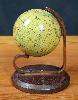
Imprint: London, 1857
A globe 65 mm. (2.5 inches) in diameter and made of papier mache with a plaster coating and 12 copper engraved printed paper gores running from north to south poles affixed, hand-coloured and varnished by the publisher. The sphere is mounted by the use of two polar metal pivots on to a plain brass meridian half-circle on a wooden stand, the whole standing 100 mm high. In good condition.
According to Elly Dekker James Manning was producing globes between 1854 and 1863. This particular one is dated 1857 and includes the new state of Victoria in Australia but was issued before the creation of Queensland. Manning published globes up to 12 inches in diameter principally for educational purposes. Dekker, Elly. (1999). 'Globes at Greenwich'.
Stock number:8184.
|
|

Imprint: New York, 1853
Binding: Hardback Octavo (230 x 145 mm.), original ornate blind embossed boards with gilt title to upper board, with two folding maps pasted to the inside of each board; 685 x 1555 mm., and 865 x 415 mm., occasional foxing, creases, a few splits, otherwise in good condition.
This portfolio was issued to accompany Captain Marcy's book 'Exploration of the Red River of Louisiana, in the Year 1852'. The two maps contained record important explorations of the region of Texas, Oklahoma, Louisiana, New Mexico, Arizona, Missouri and Arkansas. The larger map is entitled 'Map of the Country Between the Frontiers of Arkansas and New Mexico embracing the section explored in 1849, 50, 51 & 52. Also a continuation of the emigrant road from Fort Smith and Fulton down the Valley of the Gila'. It incorporates information not only from Marcy's exploration but also those of Emory, Sitgreaves and Cordova. It extends from the Mississippi River to the Colorado River in the west, mostly depicting portions of Texas. It is bound with 'Map of the Country Upon Upper Red-River, Explored in 1852 by Capt. R.B. Marcy, 5th U.S. Infantry'. The lower portion illustrates a side-profile of the Wichita Mountains. Day, Maps of Texas 900; Howes M276; Wagner-Camp 226:1; Wheat Transmississippi West 791.
Stock number:8967.
|
|

Imprint: Paris, 1653
395 x 555 mm., early outline colour, with a small rustmark upper left otherwise in good condition.
This uncommon map of Perigort in France was published in Paris by Pierre Mariette (c.1602-1658) in the 'Theatre Geographique de France'. The atlas was first published in 1650 but this map only appears in the second edition of 1653. The town of Bergerac may be seen in the centre of the map which is finished with an ornate title cartouche upper left. It is engraved by Jean Somer. Pastoureau Mariette B no. 68.
Stock number:8192.
|
|
|
Imprint: London, 1759-63
Quarto, two volumes (210 x 130 mm. each), full contemporary calf, ornate blind panels with gilt border, rebacked with raised bands, double gilt ruled compartments, red calf gilt title labels and gilt volume numbers, light wear. Volume I pp. (iv), 410, (8) with 14 county maps, 2 town plans of Bath and Hastings, 1 folding map of the environs of London (not called for); volume II pp. (2), 392, (10) and 27 further maps. Extra illustrated, light water stain at front of first volume, otherwise in good condition.
Benjamin Martin (1705-82) was baptised in Surrey and married in Chichester in 1729. There he became a schoolmaster for a short while before touring the country giving lectures. A self-educated person he spent his life following several enlightenment style subjects of interest and encouraged others through education and publishing. His school background also allied with his desire to encourage learning amongst the masses, his publications were all priced affordably. He also took over the globe-making business of James Ferguson and made optical and mathematical instruments. Reflecting his broad interests in natural philosophy he announced in November 1754 his plan for a General Magazine. The publisher was to be William Owen who was very experienced at part works. It was launched on 1 February 1755 as The General Magazine of Arts and Sciences and was issued in parts until 1764. Most of the accompanying text was written by Martin himself. Part of the work describes the counties of England and Wales and illustrates them with maps engraved by Emanuel Bowen.This is a rare two-volume topographical work on the counties of England and Wales utilising the text and plates from part of the General Magazine. The counties are described in âCamdenâ order beginning in the south west. The list of counties on the title page of volume II omits in error, those of Huntingdonshire, Leicestershire and Rutland. This example includes the folding plan of London often missing. It is extra illustrated with some early plates dating from the early 1800s. Martin was declared bankrupt 7 January 1782 and died following a suicide attempt on 9 February. Provenance: bookplate of J. Twemlow Esq. pasted inside front cover of both volumes; private English collection. Chubb (1927) 215; Hodson (1984-97) no. 230; Shirley (2004) T.Mart 1a.
Stock number:10168.
|
|
Imprint: Paris, 1839
415 x 810 mm., large folding map in early outline colour as issued, one or two light creases, some browning to upper margin and water stain to lower margins not affecting the map, otherwise in good condition with no major splits or tears.
A fine example of this very rare map which accompanied the finest colour plate book on the North American Indian ever printed entitled 'Reise in das inner Nord-America ...' It is particularly rare is it accompanied the text volumes printed to accompany the fine aquatint plates more often found. It charts one of the more remarkable voyages of exploration undertaken within the present United States. Prince Maximilian of Wied-Neuwied (1782-1867) was a noted German explorer, ethnologist and naturalist. Joining the Prussian army in 1800 he fought through the Napoleonic Wars and left at the end in 1815. An early friend of Alexander Humboldt Maximilian led his own expedition to Brazil in 1815-17. In 1832 after hiring the Swiss artist Karl Bodmer he set out again this time to the waters of the Missouri River and the Plains. The region was little known at the time. They started out from St. Louis and travelled on the Yellowstone, an American Fur Company steamboat stopping at their various forts. Changing vessels along the way they continued Fort Union, Fort Clark and Fort Mackenzie. They observed the Assiniboin, Cree, Mandan, Minatare and Crow peoples. From here they returned south reaching St. Louis in May 1834.Whilst Prince Maximilian returned to Germany to write his account Karl Bodmer travelled to Paris to prepare his famous aquatint plates from his collection of watercolours. Together their finished work would be considered one of the most sympathetic and accurate recordings of the Plains Indians issued just prior to their virtual extinction with a decade. This was ironically brought about by the very method used to document them in the first place. In The Plains Indians, the historian Paul H. Carlson states the smallpox outbreak was traced to contact between deckhands of the steamboats of the American Fur Company and the natives.Wheat records that Prince Maximilian was given a map in 1833 by Major Benjamin OFallon who was the nephew of William Clark author of the map who along with Meriwether Lewis had crossed the region to reach the Pacific Ocean earlier in the century. OFallon had joined Clark in 1808 and was also present on Stephen Longs expedition to the Rocky Mountains in 1819-20. By the time of Prince Maximilian expedition he was one of the most experienced travellers in the region. No doubt the version he passed to the Prince would have been updated considerably since the Lewis and Clark expedition. The fact that the printed map includes the route of Long is clear indication of that. The Prince is said to have completed it and removed its deficiencies. Since the publication of Wheat further research has identified that the cartographer was Lt. Col. William Thorn who used as a base map Henry Tanner's Map of the United States of America published in 1837. The map includes large insets of the Missouri River lower left and one of the source of the Mississippi River According to Schoolcraft lower right. The whole is finished with a dramatic title cartouche illustrating a buffalo hunting scene.Maximilians insisted that the text be published in a deluxe edition, which made publishers wary. The popularity of such works was waning. Maximilian persisted and in 1839 the first text and prints were ready for distribution to a disappointingly few subscribers. A French edition in 1840-42 and the English translation in 1843 were no more successful. Bodmer spent a total of eight years supervising a group of the best French and Swiss etchers to produce the aquatints. The original copperplate for the map was recently found amongst the original watercolours in the Joslyn Art Museum, Omaha, Nebraska. Provenance: private German collection; private English collection. Abbey Travel 615; Field 1036; Graff 4649; Howes M443a; Howgego (2004) 'Encyclopedia of Exploration 1800 to 1850' W30; Rumsey 3839; Sabin 47014; Wagner-Camp-Becker 76:1; Wheat Transmississippi West II no. 445 pp. 49, 166-7.
Stock number:8228.
|
|

Imprint: Philadelphia, D. Rice and A. N. Hart, 1854
Octavo (270 x 185 mm.), 3 volumes, early elaborate blind stamped full calf, blind compartments to gilt ribbed spine with gilt embossed titles. With hand-coloured lithograph frontispiece leaf and 120 coloured lithographic plates, most with tissue guards, some foxing to text and guards but the plates are generally very clean.
The Indian Tribes of North America by Thomas McKenney and James Hall first published in folio between 1836-44 is one of the great North American Indian colour plate books and the grandest published in America to date. The 120 portraits it contained were largely drawn from the paintings of the artist Charles Bird King of visiting Indian delegates to Washington D.C. They were commissioned by McKenney on behalf of the War Department. Unfortunately these were destroyed in a fire at the Smithsonian in 1865. McKenney & Halls work is therefore the only accurate record of many of the great Indian figures of the nineteenth century.McKenney was the Superintendent of Indian trade from 1816-1822 and became concerned about the future survival of the western tribes. Not afraid to speak his mind he was eventually made head of the US Bureau of Indian Affairs by President Monroe from 1824-1830. This position took him on several trips to the west to oversee treaties with the Chippewa, Menominee and Winnebago. James Hall was a banker from Cincinnati who had been a journalist in Illinois, lawyer and state treasurer. The two of them collaborated to produce this book. The text was written by Hall but drew on the knowledge of McKenney. The work contains a general history of North American Indians and 120 biographies, each accompanied by a fine lithographic plate. It was an immediate success.Between 1848 and 1850 an octavo edition was published with 120 lithographs drawn by J. T. Bowen. The quality of the plates was such that it is stated that any of the first four editions include high quality images in terms of printing and colouring. This is an example of the second octavo edition published by D. Rice and A. N. Hart. Provenance: with bookplate of Frank Henry Goodyear Library; acquired 1994 for private English collection. Horan 'The McKenney-Hall Portrait Gallery of American Indians'; Howes M129; Miles & Reese 'America Pictured to the Life' no. 53; Sabin 43411; Viola 'Thomas L. McKenney, Architect of America's Early Indian Policy: 1816-30'; Viola The Indian Legacy of Charles Bird King.
Stock number:7782.
|
|

Imprint: London, Joseph Clinton Robertson (editor), January 3, 1823
Octavo, issue no. 19, pp. 289-304, light wear to corners, last leaf detached, otherwise in good condition.
The Mechanics Magazine is one of the finest sources for material on nineteenth century mechanics. It was founded in 1829 by Joseph Clinton Robertson (1788-1852), a patent agent in Fleet Street, London, who was therefore well placed to publish it. This particular weekly number features on its front cover two fabulous images of early steam railway engines. This illustrates the first article entitled Proposition for a General Iron Rail-Way, with Steam-Engines to Supersede the Necessity of Horses in All Public Vehicles. Dated 3 January 1823 this is one of the earliest references to the railways. Indeed the first passenger line was opened in 1925 between Stockton and Darlington by Edward Pease, ancestor of Lord Wardington.
Stock number:7830.
|
|

Imprint: Amsterdam, 1767
165 x 195 mm., in very good condition.
A very rare map by Peiter Meijer published in "Algemeene Oefenschoole" which was issued in two volumes in 1763 and 1770. The work is a translation of and designed as Benjamin Martin's "Natural History of England", 1755-63. The date of Martin's issue 1757 is found in the imprint lower left. This is the first map in the first volume and curiously misspells Emanuel Bowen as the author as 'Brown'. Hodson Atlases 260; not in Quixley (1966).
Stock number:9255.
|
|
|
Imprint: Amsterdam, 1765-[70]
190 x 175 mm., in very good condition.
A very rare map by Peiter Meijer published in "Algemeene Oefenschoole" which was issued in two volumes in 1763 and 1770. The work is a translation of Benjamin Martin's 'Natural History of England', 1755-63. Similarly, it describes the counties and illustrates them with a series of county maps. Like the Martin this two volume atlas forms only part of a larger thirty-one volume work. The title 'Algemeene Oefenschoole van Konsten en Weetenschappen' is translated as 'General Academy of Arts and Sciences'. Published in parts like the Martin we can deduce the maps were published between 1757 and 1770 from their presence on each map. The open acknowledgement of Emanuel Bowen as originator of the maps might indicate some form of approval from Martin for the work. It does not appear to have been a commercial success judging by its rarity. This map appears in the second volume. The engraver of the maps is Leonard Janszoon Schenck (1732-1800) whose name appears on the maps. The titles have been almost directly translated with the addition of a credit to Bowen and date of issue.Not in Chubb; Hodson (1984-97) 260; Koeman (1967-70) Supplement Meij 2 & Meij 1; Shirley (2004) Mei 1a; Tooley's Dictionary (1999-2004).
Stock number:9755.
|
|