|
|

Imprint: Amsterdam, R & J Wetstenii & G Smith, 1578-[1730]
350 x 460 mm., a fine example in recent wash colour.
Gerard Mercator's edition of Ptolemy's 'Geography' is highly acclaimed, he spent much of his life studying the work and even engraved the plates himself. The 'Geographia' is the earliest surviving geographical treatise. Much of Mercator's efforts were spent projecting Ptolemy's geography onto the projection which bears his name. Mercator is one of the worlds greatest cartographers and the 'Claudii Ptolemaei Tabulae Geographicae Orbis Terrarum' was first published in 1578. This map is centred on Armenia and shows the Black Sea and Caspian Sea to the west and east respectively. It is in the third state with the addition of a latitude and longitude grid illustrating the projection. Koeman Me 5; Nordenskiold 234; Phillips, P.L. (Atlases) 384; Shirley BL T.Ptol-11a & 11k; Van der Krogt, P. (Atlantes) 1:501.
Stock number:6095.
|
|

Imprint: Amsterdam, R & J Wetstenii & G Smith, 1578-[1730]
360 x 460 mm., a fine example in recent wash colour.
Gerard Mercator's edition of Ptolemy's 'Geography' is highly acclaimed, he spent much of his life studying the work and even engraved the plates himself. The 'Geographia' is the earliest surviving geographical treatise. Much of Mercator's efforts were spent projecting Ptolemy's geography onto the projection which bears his name. Mercator is one of the worlds greatest cartographers and the 'Claudii Ptolemaei Tabulae Geographicae Orbis Terrarum' was first published in 1578. This map focuses on the Caucasus and modern day Russia is in the third state with the addition of a latitude and longitude grid illustrating the projection. It displays the Crimean Peninsula lower left and the Caspian Sea lower right. Koeman Me 5; Nordenskiold 234; Phillips, P.L. (Atlases) 384; Shirley BL T.Ptol-11a & 11k; Van der Krogt, P. (Atlantes) 1:501.
Stock number:6094.
|
|

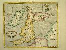
Imprint: Utrecht, Francois Halma, 1578-[c.1695]
350 x 470 mm., a fine example in modern wash colour.
From Gerard Mercator's edition of 'Claudii Ptolemaei Tabulae Geographicae Orbis Terrarum'. It was in 1578 that one of the world's greatest cartographers put out an edition of the earliest surviving geographical treatise. This map centres on India although there is not much of a peninsula. Its presence can be determined by the Indus and Ganges Rivers on the left and right respectively. Sri Lanka can be seen at the bottom of the map. Koeman Me 5; Nordenskiold 234; Phillips, P.L. (Atlases) 384; Shirley BL T.Ptol-11a & 11k; Van der Krogt, P. (Atlantes) 1:501.
Stock number:4023.
|
|

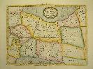
Imprint: Duisburg., 1585
Edition: First Edition 36 x 47 cms., in fine early wash colour. Good condition
This map of South West Switzerland is in fine early wash colour. Also it is from the first edition of the atlas in 1585 with Latin text to the verso. Van der Krogt, P. (Atlantes) 4920:1A.1.
Stock number:4068.
|
|

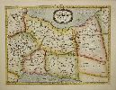
Imprint: Amsterdam, c.1620
360 x 420 mm., modern wash colour, in good condition.
Gerard Mercator's regional map of the east of England taking in the east coast including Norfolk, Lincolnshire, Yorkshire and inland Rutland, Leicestershire, Nottinghamshire, Derbyshire, and Staffordshire. The preferred first state with the more ornate title cartouche, stippled north sea and Mercator's imprint lower right. With German text to the verso. Deadman & Brooks 'Leicestershire' p. 320; Koeman II ME 12 p. 292 no. 94; Van der Krogt, P. (Atlantes) 5113:1.2.
Stock number:8308.
|
|

Imprint: Amsterdam, R & J Wetstenii & G Smith, 1578-[1730]
360 x 460 mm., a fine example in recent wash colour.
Gerard Mercator's edition of Ptolemy's 'Geography' is highly acclaimed, he spent much of his life studying the work and even engraved the plates himself. The 'Geographia' is the earliest surviving geographical treatise. Much of Mercator's efforts were spent projecting Ptolemy's geography onto the projection which bears his name. Mercator is one of the worlds greatest cartographers and the 'Claudii Ptolemaei Tabulae Geographicae Orbis Terrarum' was first published in 1578. This map of south eastern Europe is centred on the River Danube and is in the third state with the addition of a latitude and longitude grid illustrating the projection. Koeman Me 5; Nordenskiold 234; Phillips, P.L. (Atlases) 384; Shirley BL T.Ptol-11a & 11k; Van der Krogt, P. (Atlantes) 1:501.
Stock number:6086.
|
|

Imprint: Utrecht, Francois Halma., 1578-[c.1695]
330 x 465 mm., a fine example in modern wash colour.
From Gerard Mercator's edition of 'Claudii Ptolemaei Tabulae Geographicae Orbis Terrarum'. It was in 1578 that one of the worlds greatest cartographers put out an edition of the earliest surviving geographical treatise. A fine decorative map of the country from Rhaetia to Dalmatia. Koeman Me 5; Nordenskiold 234; Phillips, P.L. (Atlases) 384; Shirley BL T.Ptol-11a & 11k; Van der Krogt, P. (Atlantes) 1:501.
Stock number:4034.
|
|

Imprint: Utrecht, Francois Halma., 1578-[c.1695]
35 x 43 cms., in modern wash colour.
From Gerard Mercator's edition of 'Claudii Ptolemaei Tabulae Geographicae Orbis Terrarum'. It was in 1578 that one of the worlds greatest cartographers put out an edition of the earliest surviving geographical treatise. This map shows north eastern Europe and Russia. With an attractive scene of a camp upper right. The map extends southwards to the Black Sea. Koeman Me 5; Nordenskiold 234; Phillips, P.L. (Atlases) 384; Shirley BL T.Ptol-11a & 11k; Van der Krogt, P. (Atlantes) 1:501.
Stock number:4019.
|
|

Imprint: Amsterdam, R & J Wetstenii & G Smith, 1578-[1730]
350 x 430 mm., in recent wash colour.
Gerard Mercator's edition of Ptolemy's 'Geography' is highly acclaimed; he spent much of his life studying the work and even engraved the plates himself. The 'Geographia' is the earliest surviving geographical treatise. Much of Mercator's efforts were spent projecting Ptolemy's geography onto the projection which bears his name. Mercator is one of the world's greatest cartographers and the 'Claudii Ptolemaei Tabulae Geographicae Orbis Terrarum' was first published in 1578. This map of north eastern Europe and Russia is in the third state with the addition of a latitude and longitude grid illustrating the projection. With an attractive scene of a camp upper right. The map extends southwards to the Black Sea. Koeman Me 5; Nordenskiold 234; Phillips, P.L. (Atlases) 384; Shirley BL T.Ptol-11a & 11k; Van der Krogt, P. (Atlantes) 1:501.
Stock number:6085.
|
|

Imprint: Utrecht, Francois Halma., 1578-[c.1695]
34 x 40 cms., a fine example in modern wash colour.
From Gerard Mercator's edition of 'Claudii Ptolemaei Tabulae Geographicae Orbis Terrarum'. It was in 1578 that one of the worlds greatest cartographers put out an edition of the earliest surviving geographical treatise. Ptolemy's image of France as seen through the eyes of Mercator. Koeman Me 5; Nordenskiold 234; Phillips, P.L. (Atlases) 384; Shirley BL T.Ptol-11a & 11k; Van der Krogt, P. (Atlantes) 1:501.
Stock number:4032.
|
|

Imprint: Utrecht, Francois Halma, 1578-[c.1695]
350 x 410 mm., with recent wash colour, a fine example.
From Gerard Mercator's edition of 'Claudii Ptolemaei Tabulae Geographicae Orbis Terrarum'. It was in 1578 that one of the worlds greatest cartographers put out an edition of the earliest surviving geographical treatise. A Ptolemaic map of Germany as seen through the eyes of Mercator. Koeman Me 5; Nordenskiold 234; Phillips, P.L. (Atlases) 384; Shirley BL T.Ptol-11a & 11k; Van der Krogt, P. (Atlantes) 1:501.
Stock number:5615.
|
|

Imprint: Amsterdam, R & J Wetstenii & G Smith, 1578-[1730]
340 x 400 mm., a fine example in recent wash colour.
Gerard Mercator's edition of Ptolemy's 'Geography' is highly acclaimed, he spent much of his life studying the work and even engraved the plates himself. The 'Geographia' is the earliest surviving geographical treatise. Much of Mercator's efforts were spent projecting Ptolemy's geography onto the projection which bears his name. Mercator is one of the worlds greatest cartographers and the 'Claudii Ptolemaei Tabulae Geographicae Orbis Terrarum' was first published in 1578. This map of France is in the third state with the addition of a latitude and longitude grid illustrating the projection. Koeman Me 5; Nordenskiold 234; Phillips, P.L. (Atlases) 384; Shirley BL T.Ptol-11a & 11k; Van der Krogt, P. (Atlantes) 1:501.
Stock number:6080.
|
|

Imprint: Amsterdam, c.1610
340 x 420 mm., recent colour.
From the 'Atlas sive Cosmographicae'.
Stock number:2642.
|
|

Imprint: Duisburg, 1589-[1609]
370 x 480 mm. Lovely early wash coloured copplerplate engraving.
A nice fresh example on good paper. Van der Krogt, P. (Atlantes) 7310:1A
Stock number:2891.
|
|
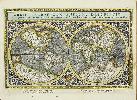
Imprint: Venice, 1596
160 x 245 mm., in outline colour, with light foxmark to right, otherwise in good condition.
For this new edition of Ptolemys Geography edited by Giovanni Antonio Magini, a noted geographer from Padua, this double hemispheric world map was engraved. it is neatly engraved by Girolamo Porro derived from the Rumold Mercator map of 1587. A tremendous amount of detail has been included with magnificent detailed engraving. The atlas contains the 27 Ptolemaic plates and a further 36 modern maps of the world. The work is often found lacking this initial Mercator world map. Provenance: The Map House 1973; private collection of Rodney Shirley. Nordenskiöld (1979) no. 223; Nordenskiöld (1889) p. 27; Phillips (1909-) no. 436; Sabin (1868) no. 66508; Shirley 'world' 194; Shirley 'Atlases in the British Library' T.Ptol 12a; Wagner (1937) no. 186.
Stock number:9480.
|
|

Imprint: Amsterdam, 1595-[c.1606]
Inscription: Signed, Inscribed Or Annotated 355 x 480 mm., recent wash colour, with Dutch text to the verso, good condition.
An attractive map of Valencia, Spain, displaying the coastline from Cartagena to Benicarlo with the west oriented to the top. With very ornate cartouches containing the title and scale of distance, finished by the inclusion of a sailing ship and sea monster. The sea is engraved in Mercator's signature moiré-pattern. Dutch text on verso. Van der Krogt, P. (Atlantes) 6155:1.1.
Stock number:6049.
|
|

Imprint: Amsterdam, 1589-[1609]
340 x 480 mm., in good modern colour, fine condition on strong paper.
This fine map of Sicily by Gerard Mercator was first issued in the second part of Mercator's 'Atlas Sive Cosmographiae' entitled 'Italiae, Sclavoniae et Graeciae' published in Duisberg, 1589. After the acquisition of Mercator's stock in 1604 by Jodocus Hondius the production of the atlas moved to Amsterdam. This edition is with French text on the verso. Koeman II ME 13A no. 66; Van der Krogt, P. (Atlantes) 7510:1A.1.
Stock number:4181.
|
|
Imprint: Amsterdam, R & J Wetstenii & G Smith, 1578-[1730]
340 x 460 mm., a fine example in recent wash colour.
Gerard Mercator's edition of Ptolemy's 'Geography' is highly acclaimed, he spent much of his life studying the work and even engraved the plates himself. The 'Geographia' is the earliest surviving geographical treatise. Much of Mercator's efforts were spent projecting Ptolemy's geography onto the projection which bears his name. Mercator is one of the worlds greatest cartographers and the 'Claudii Ptolemaei Tabulae Geographicae Orbis Terrarum' was first published in 1578. This map of Persia or modern day Iran is in the third state with the addition of a latitude and longitude grid illustrating the projection. Koeman Me 5; Nordenskiold 234; Phillips, P.L. (Atlases) 384; Shirley BL T.Ptol-11a & 11k; Van der Krogt, P. (Atlantes) 1:501.
Stock number:6096.
|
|
Imprint: Amsterdam, 1578-[1695]
340 x 460 mm., in full recent wash colour, good condition.
Gerard Mercator's edition of Ptolemy's 'Geography' is highly acclaimed; he spent much of his life studying the work and even engraved the plates himself. The 'Geographia' is the earliest surviving geographical treatise. Much of Mercator's efforts were spent projecting Ptolemy's geography onto the projection which bears his name. Mercator is one of the world's greatest cartographers and the 'Claudii Ptolemaei Tabulae Geographicae Orbis Terrarum' was first published in 1578. This map of Persia or modern day Iran is in the scond state before the addition of a latitude and longitude grid illustrating the projection. Alai, Cyrus. (2003). Mapping Persia: A brief introduction, in IMCoS Journal 94 pp. 5-22; Koeman Me 5; Nordenskiold 234; Phillips, P.L. (Atlases) 384; Shirley BL T.Ptol-11a; Van der Krogt, P. (Atlantes) 1:501.
Stock number:9641.
|
|
Imprint: Amsterdam, R & J Wetstenii & G Smith, 1578-[1730]
340 x 400 mm., recent wash colour, in good condition.
Gerard Mercator's edition of Ptolemy's 'Geography' is highly acclaimed, he spent much of his life studying the work and even engraved the plates himself. The 'Geographia' is the earliest surviving geographical treatise. Much of Mercator's efforts were spent projecting Ptolemy's geography onto the projection which bears his name. Mercator is one of the worlds greatest cartographers and the 'Claudii Ptolemaei Tabulae Geographicae Orbis Terrarum' was first published in 1578. This map of the British Isles is in the third state with the addition of a latitude and longitude grid illustrating the projection. Koeman Me 5; Nordenskiold 234; Phillips, P.L. (Atlases) 384; Shirley BI 123; Shirley BL T.Ptol-11a & 11k; Van der Krogt, P. (Atlantes) 0901:1.2.
Stock number:6078.
|
|