|
|

Imprint: Utrecht, Francois Halma, 1578-[c.1695]
350 x 455 mm., with recent wash colour, some marginal discolouration not effecting the image, otherwise a good example.
From Gerard Mercator's edition of 'Claudii Ptolemaei Tabulae Geographicae Orbis Terrarum'. It was in 1578 that one of the world's greatest cartographers put out an edition of the earliest surviving geographical treatise. Koeman Me 5; Nordenskiold 234; Shirley BL T.Ptol-11a & 11k; Zacharakis 1850.
Stock number:3784.
|
|
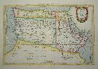
Imprint: Utrecht, Francois Halma, 1578-[c.1695]
310 x 470 mm., in fine modern wash colour and in good condition.
From Gerard Mercator's edition of 'Claudii Ptolemaei Tabulae Geographicae Orbis Terrarum'. It was in 1578 that one of the world's greatest cartographers put out an edition of the earliest surviving geographical treatise. This map shows the northern half of Africa with the equator displayed prominently. The source of the Nile River is also highlighted with a mountain range feeding two large lakes. An interesting feature is the Niger River in 'Libya' which is prominent across the map with its source in numerous lakes. During its course to the sea it disappears under a mountain range arising the other side. Although Mercator is most renowned today for the projection he popularised and for first using the term 'atlas' for a collection of maps, he devoted much of his life to his Ptolemaic maps. The maps were beautifully engraved as nearly as possible to their original form and are the most decorative of Ptolemaic maps. Koeman Me 5; Nordenskiold 234; Phillips, P.L. (Atlases) 384; Shirley BL T.Ptol-11a & 11k; Van der Krogt, P. (Atlantes) 1:501.
Stock number:5206.
|
|

Imprint: Amsterdam, R & J Wetstenii & G Smith, 1578-[1730]
310 x 460 mm., a fine example in recent wash colour.
Gerard Mercator's edition of Ptolemy's 'Geography' is highly acclaimed, he spent much of his life studying the work and even engraved the plates himself. The 'Geographia' is the earliest surviving geographical treatise. Much of Mercator's efforts were spent projecting Ptolemy's geography onto the projection which bears his name. Mercator is one of the worlds greatest cartographers and the 'Claudii Ptolemaei Tabulae Geographicae Orbis Terrarum' was first published in 1578. This map shows the northern half of Africa with the equator displayed prominently is in the third state with the addition of a latitude and longitude grid illustrating the projection. The source of the Nile River is also highlighted. Koeman Me 5; Nordenskiold 234; Phillips, P.L. (Atlases) 384; Shirley BL T.Ptol-11a & 11k; Van der Krogt, P. (Atlantes) 1:501.
Stock number:6092.
|
|
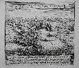
Imprint: Frankfurt, c.1660
280 x 300 mm., in good condition.
A excellent early view of the Venetian attack on Split published in Matthaus Merian's 'Theatrum Europaeum'. There were a total of 21 volumes in this huge work. The book was begun in 1635 by Matthaus Merian the Elder and continued by his son of the same name, the Younger, upon his death in 1650.
Stock number:7633.
|
|

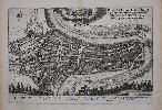
Imprint: Frankfurt, c.1655
220 x 285 mm., in good condition.
Matthaus Merian began publishing the 'Theatrum Europaeum' in 1633, it was not finished until 1738 by which time 21 volumes had been issued including some 20,000 pages of text, 720 maps, plans, views and other engravings and nearly 700 portraits. This is a birds eye view of Schloss Wiserat on the River Muldau or Vltava, now in the Czech Republic.
Stock number:9680.
|
|

Imprint: Frankfurt, c.1655
235 x 285 mm, in good condition.
Matthaus Merian began publishing the 'Theatrum Europaeum' in 1633, it was not finished until 1738 by which time 21 volumes had been issued including some 20,000 pages of text, 720 maps, plans, views and other engravings and nearly 700 portraits. This plate illustrates the Swedish invasion of Prussia by King Gustavus Adolphus in May 1626. The force consisted of 125 ships and 8,000 men.Although successful he failed to capture Dantzig.
Stock number:9682.
|
|

Imprint: Frankfurt, c.1676
325 x 400 mm., narrow margins at the top otherwise in good condition.
Matthaus Merian began publishing the 'Theatrum Europaeum' in 1633, it was not finished until 1738 by which time 21 volumes had been issued including some 20,000 pages of text, 720 maps, plans, views and other engravings and nearly 700 portraits. This image depicts the battle between the Danish and Swedish on the River Lydde one cold day in December 1676. The Swedish apparently in the weaker position managed to pull off a remarkable victory.
Stock number:8180.
|
|
|
Imprint: Frankfurt, c.1655
190 x 285 mm., in good condition.
This plan of Aix-en-Provence in southern France is from the 'Topographia Gallia' by Martin Zeiler published 1655-61. All of the plates were the work of Matthaus Merian, one of the finest engravers of the seventeenth century.
Stock number:7967.
|
|

Imprint: Frankfurt, c.1650
280 x 360 mm., with recent wash colour, in good condition.
Matthaus Merian began publishing the 'Theatrum Europaeum' in 1633, it was not finished until 1738 by which time 21 volumes had been issued including some 20,000 pages of text, 720 maps, plans, views and other engravings and nearly 700 portraits. Many of the earliest plates were issued in Johann Angel von Werdenhagen's 'De Rebus Publicis Hanseaticus' of 1644 including this fine plan of Antwerp. A keys helps to identify 32 places on the map. Fauser, A. 547; Shirley BL G.Werd 1a no. 116 & G.Meri 1a.
Stock number:4656.
|
|

Imprint: Frankfurt, c.1650
280 x 320 mm., in good condition.
A fine birds-eye view of the town of Ardebil (Ardabil) in northwestern Iran near the south west shore of the Caspian Sea. Matthaus Merian began publishing the 'Theatrum Europaeum' in 1633, it was not finished until 1738 by which time 21 volumes had been issued including some 20,000 pages of text, 720 maps, plans, views and other engravings and nearly 700 portraits. Shirley BL G.Mer 1a.
Stock number:4949.
|
|

Imprint: Frankfurt, c.1640
200 x 305 mm., in good condition.
Matthaus Merian began publishing the 'Theatrum Europaeum' in 1633, it was not finished until 1738 by which time 21 volumes had been issued including some 20,000 pages of text, 720 maps, plans, views and other engravings and nearly 700 portraits. Many of the earliest plates were issued in Johann Angel von Werdenhagen's 'De Rebus Publicis Hanseaticus' of 1644 and Johann Ludwig Gottfried's 'Neuwe Archontologia Cosmica' of 1638. The latter included this fine plan of Augsburg complete with a key to identify 29 places on the map. Shirley BL G.Gott 1a no. 20 & G.Mer 1a.
Stock number:4855.
|
|

Imprint: Paris, c.1655
270 x 350 mm., in good condition.
A plan of Basel from Werdenhagen's 'De Rebuspublicis Hanseaticus Tractatus'. Shirley 'Atlases in the British Library' G.Werd 1a no. 30.
Stock number:8629.
|
|

Imprint: Frankfurt, c.1640
280 x 360 mm., in good condition.
Matthaus Merian began publishing the 'Theatrum Europaeum' in 1633, it was not finished until 1738 by which time 21 volumes had been issued including some 20,000 pages of text, 720 maps, plans, views and other engravings and nearly 700 portraits. This view depicts the siege of Mainz in 1635 with a legend upper left identifying key features. Shirley 'Atlases in the British Library' G-Loti 1a no. 22.
Stock number:5752.
|
|

Imprint: Frankfurt, c.1674
210 x 290 mm., in good condition.
Matthaus Merian began publishing the 'Theatrum Europaeum' in 1633, it was not finished until 1738 by which time 21 volumes had been issued including some 20,000 pages of text, 720 maps, plans, views and other engravings and nearly 700 portraits. This image depicts the Battle for the Castle of Wasslen by the forces of Baron von Goltz for Brandenburg against the Swedish. It was fought on 22 October 1674.
Stock number:8186.
|
|
Imprint: Frankfurt, c.1720
490 x 620 mm., early outline colour, in good condition on thick paper.
Matthaus Merian began publishing the 'Theatrum Europaeum' in 1633, it was not finished until 1738 by which time 21 volumes had been issued including some 20,000 pages of text, 720 maps, plans, views and other engravings and nearly 700 portraits. This image depicts the city of Bern from a birds-eye perspective. Costumes figures decorate the map below..
Stock number:8122.
|
|
|
Imprint: Frankfurt, c.1656
290 x 370 mm., birds eye view in good condition.
A fine birds-eye view of the Siege of Warsaw in 1656. A major battle fought between Poland and Sweden in the Second Northern War 1655-60. Matthaus Merian (1593-1650) began publishing the 'Theatrum Europaeum' in 1633, it was not finished until 1738 by which time 21 volumes had been issued including some 20,000 pages of text, 720 maps, plans, views and other engravings and nearly 700 portraits. Shirley (2004) G.Meri 7a no. 6.
Stock number:9707.
|
|

Imprint: Frankfurt, c.1655
290 x 380 mm., in good condition.
Matthaus Merian began publishing the 'Theatrum Europaeum' in 1633, it was not finished until 1738 by which time 21 volumes had been issued including some 20,000 pages of text, 720 maps, plans, views and other engravings and nearly 700 portraits. This is a map of Brandenburg in Germany, wonderfully engraved by the talented Matthaus Merian. Berlin is situated just below the middle of the map.
Stock number:9687.
|
|
|
Imprint: Frankfurt, c.1655
185 x 335 mm., slight paper crease right side, otherwise in good condition.
This view of Chaalons is from the 'Topographia Gallia' by Martin Zeiler published 1655-61. It formed just one volume of the 'Topographiae' series which began in 1642 with a volume on Switzerland and extended to much of Europe. The final work covers Italy in 1688. All of the plates were the work of Matthaus Merian (1593-1650). Born in Basle, Switzerland, he was one of the finest engravers of the seventeenth century. He was renowned for his town plans and views. He married the daughter of Theodore de Bry. Chaalons en Champaigne is the capital of Marne in eastern France and was only officially renamed thus in 1998. Previously it was known as Chalons-sur-Marne. The River Marne flows through the foreground. Shirley (2004) G.Meri 22a.
Stock number:9692.
|
|

Imprint: Frankfurt, 1638
280 x 335 mm., in good condition.
A detailed early map of the regions of Champagne and Brie in France. From the 'Theatrum Europaeum'. Shirley BL G.Meri 1a.
Stock number:8703.
|
|

Imprint: Frankfurt, c.1655
280 x 330 mm., in good condition.
From the 'Topographia Gallia' by Martin Zeiler published 1655-61. All of the plates were the work of Matthaus Merian, one of the finest engravers of the seventeenth century. A fine detailed plan of the town of Charleville-Mezieres in the Ardenne. The key buildings are all displayed in birds eye profile.
Stock number:7961.
|
|