|
|
|
Imprint: Frankfurt, c.1655
205 x 340 mm., in good condition.
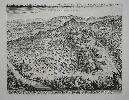
This birds-eye plan/ view of Collioure in southern France is from the 'Topographia Gallia' by Martin Zeiler published 1655-61. All of the plates were the work of Matthaus Merian, one of the finest engravers of the seventeenth century. Collioure is a town near the Spanish border at the foot of the Pyrenees.
Stock number:7964.
|
|

Imprint: Frankfurt, c.1650
280 x 360 mm., a little dirt in the lower right corner otherwise fine.
Matthaus Merian began publishing the 'Theatrum Europaeum' in 1633, it was not finished until 1738 by which time 21 volumes had been issued including some 20,000 pages of text, 720 maps, plans, views and other engravings and nearly 700 portraits. Many of the earliest plates were issued in Johann Angel von Werdenhagen's 'De Rebus Publicis Hanseaticus' of 1644 including this fine plan of Cologne. Two keys help to identify 49 places on the map. Shirley BL G.Werd 1a no. 85 & G.Mer 1a.
Stock number:4642.
|
|

Imprint: Frankfurt, 1638
250 x 365 mm., with some early outline colour, in good condition.
An early detailed map of Provence in southern France extending from the mouth of the River Rhone to San Remo in Italy. From the 'Theatrum Europaeum'. Shirley BL G.Meri 1a.
Stock number:8712.
|
|

Imprint: Frankfurt, 1658
780 x 290 mm., in good condition.
Matthaus Merian began publishing the 'Theatrum Europaeum' in 1633, it was not finished until 1738 by which time 21 volumes had been issued including some 20,000 pages of text, 720 maps, plans, views and other engravings and nearly 700 portraits. In 1655 Hungary elected Leopold as its king, in the following years so did Bohemia and Croatia. July of 1658, a year after his father's death, Leopold was elected the Emperor at Frankfurt. This despite the French minister, Cardinal Mazarin's interference. He preferred to make Ferdinand Maria, Elector of Bavaria the Emperor. This is a fine large panorama of the procession of the Emperor.
Stock number:7775.
|
|

Imprint: Frankfurt, 1638
275 x 350 mm., in fine recent wash colour and good condition.
From Johann Ludwig Gottfried's 'Neuwen Archontologia Cosmica' published in 1638. A high quality engraved map of Switzerland by Matthaus Merian. Adorned with the coats of arms of the various Canton's.
Stock number:4093.
|
|
|
Imprint: Frankfurt, c.1655
215 x 330 mm., in good condition.
This birds-eye view of Villefranche in Provence, southern France, is from the 'Topographia Gallia' by Martin Zeiler published 1655-61. All of the plates were the work of Matthaus Merian, one of the finest engravers of the seventeenth century. Part of Nice is displayed in the west. The empty promontory on the right is now the home of Saint Jean Cap Ferrat, one of the most exclusive regions of Cote D'Azur.
Stock number:7972.
|
|
|
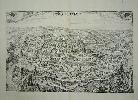
Imprint: Frankfurt, c.1655
285 x 365 mm., in good condition.
This plan of Strasbourg highlights the churches and cathedral. It is from the 'Topographia Gallia' by Martin Zeiler published 1655-61. All of the plates were the work of Matthaus Merian, one of the finest engravers of the seventeenth century.
Stock number:7968.
|
|
|
Imprint: London, 1647
295 x 370 mm., in good condition.
A birds -eye view and plan of Freiburg, just outside Dresden, during the siege of 1643. Matthaus Merian began publishing the 'Theatrum Europaeum' in 1633, it was not finished until 1738 by which time 21 volumes had been issued including some 20,000 pages of text, 720 maps, plans, views and other engravings and nearly 700 portraits. Fauser A. 4185.
Stock number:9285.
|
|

Imprint: Frankfurt, c.1650
280 x 360 mm., in good condition.
Matthaus Merian began publishing the 'Theatrum Europaeum' in 1633, it was not finished until 1738 by which time 21 volumes had been issued including some 20,000 pages of text, 720 maps, plans, views and other engravings and nearly 700 portraits. This birds-eye view is of the confluence of the River Rhine and the Moselle River. Coblenz is shown at the bottom of the print with the opposing town of Ehrenbreitstein on the other shore. Shirley 'Atlases in the British Library' G-Loti 1a no. 29.
Stock number:5750.
|
|

Imprint: Frankfurt, c.1655
235 x 305 mm., in good condition.
From the 'Topographia Gallia' by Martin Zeiler published 1655-61. All of the plates were the work of Matthaus Merian, one of the finest engravers of the seventeenth century. A fine detailed plan of the town of Dieppe in Normandy. The buildings are all displayed in birds eye profile.
Stock number:7959.
|
|

Imprint: Frankfurt, 1638
275 x 370 mm., in good condition.
A detailed early map of the environs of Paris in France. From the 'Theatrum Europaeum'. Shirley BL G.Meri 1a.
Stock number:8704.
|
|
Imprint: Frankfurt, 1648
275 x 350 mm., in good condition.
Matthaus Merian began publishing the 'Theatrum Europaeum' in 1633, it was not finished until 1738 by which time 21 volumes had been issued including some 20,000 pages of text, 720 maps, plans, views and other engravings and nearly 700 portraits. This superb birds-eye view of a battle in Alsace relates to the Thirty Years War between Spain and France. In this battle on 2 March 1634 the Swedish were defeated. The town lower left on the river is Sennen or Cernay in Alsace, France.
Stock number:8189.
|
|
Imprint: Frankfurt, c.1650
220 x 350 mm., in fine condition.
A plan of Freiburg, Switzerland, from Werdenhagen's 'De Rebuspublicis Hanseaticus Tractatus'. Shirley "Atlases in the British Library" G.Werd 1a no. 31.
Stock number:4751.
|
|

Imprint: Frankfurt, 1638
270 x 350 mm., in good condition.
Extremely decorative map of France with various coats of arms on display. From the 'Theatrum Europaeum'. Shirley BL G.Meri 1a.
Stock number:8702.
|
|

Imprint: Frankfurt, 1638
270 x 350 mm., with recent wash colour, in good condition.
Extremely decorative map of France with various coats of arms on display. From the 'Theatrum Europaeum'. Shirley BL G.Meri 1a.
Stock number:8202.
|
|

Imprint: Frankfurt, c.1650
190 x 270 mm., in fine condition.
A plan of Geneva from Werdenhagen's 'De Rebuspublicis Hanseaticus Tractatus'. Shirley Atlases in the British Library G.Werd 1a no. 37.
Stock number:4750.
|
|

Imprint: Frankfurt, 1638
280 x 370 mm., in good condition.
An early map detailing the western portions of France centred on the Loire valley. From the 'Theatrum Europaeum'. Shirley BL G.Meri 1a.
Stock number:8705.
|
|

Imprint: Frankfurt, 1638
270 x 365 mm., in good condition.
An early map detailing Gascony in France. The region is the south west of the country. Toulouse appears just upper left of the title cartouche. From the 'Theatrum Europaeum'. Shirley BL G.Meri 1a.
Stock number:8708.
|
|

Imprint: Frankfurt, 1638
275 x 360 mm., in good condition.
An early map of Languedoc in southern France extending from the Spanish Pyranees to the mouth of the Rhone river. From the 'Theatrum Europaeum'. Shirley BL G.Meri 1a.
Stock number:8710.
|
|

Imprint: Frankfurt, c.1655
190 x 285 mm., in good condition.
From the 'Topographia Gallia' by Martin Zeiler published 1655-61. All of the plates were the work of Matthaus Merian, one of the finest engravers of the seventeenth century. A fine detailed plan of the town of Honfleur in Normandy. The buildings are all displayed in birds eye profile. The town is not easily recognisable as their has been so much of the Channel reclaimed, the town is now set back from the coast.
Stock number:7965.
|
|