|
|

Imprint: London, 1772
34.5 x 41.5 cm. Uncoloured example in good condition.
Ex Edmund Gibson's edition of Camden's 'Britannia'. Gibson announced that his maps engraved by Robert Morden utilised unpublished surveys where available and the knowledge of local gentlemen who supplied corrections. Morden was an accomplished bookseller and publisher who contributed a great deal to geography and cartography. Morden's maps were very popular. 'Britannia' was first published in 1695, and subsequently in 1722, c.1730, 1753 & 1772. Refer to Skelton no. 117
Stock number:3322.
|
|

Imprint: London, 1695
345 x 415 mm. Uncoloured example in good condition.
Ex Edmund Gibson's edition of Camden's 'Britannia'. Gibson announced that his maps engraved by Robert Morden utilised unpublished surveys where available and the knowledge of local gentlemen who supplied corrections. Morden was an accomplished bookseller and publisher who contributed a great deal to geography and cartography. Morden's maps were very popular. 'Britannia' was first published in 1695, and subsequently in 1722, c.1730, 1753 & 1772. Refer to Skelton no. 117.
Stock number:5442.
|
|

Imprint: London, 1695
345 x 415 mm. Uncoloured example in good condition.
Ex Edmund Gibson's edition of Camden's 'Britannia'. Gibson announced that his maps engraved by Robert Morden utilised unpublished surveys where available and the knowledge of local gentlemen who supplied corrections. Morden was an accomplished bookseller and publisher who contributed a great deal to geography and cartography. Morden's maps were very popular. 'Britannia' was first published in 1695, and subsequently in 1722, c.1730, 1753 & 1772. Refer to Skelton no. 117.
Stock number:4841.
|
|

Imprint: London, 1695
Edition: First Edition 415 x 360 mm., with accompanying text, in good condition.
Ex Edmund Gibson's edition of Camden's 'Britannia'. Gibson announced that his maps engraved by Robert Morden utilised unpublished surveys where available and the knowledge of local gentlemen who supplied corrections. Morden was an accomplished bookseller and publisher who contributed a great deal to geography and cartography. Morden's maps were very popular. 'Britannia' was first published in 1695, and subsequently in 1722, c.1730, 1753 & 1772. This is an example from the first edition. Saunders p. 48; Skelton no. 117.
Stock number:8081.
|
|

Imprint: London, 1695
Edition: First Edition 360 x 420 mm., very light mark in part of the centrefold otherwise in good condition.
Ex Edmund Gibson's edition of Camden's 'Britannia'. Gibson announced that his maps engraved by Robert Morden utilised unpublished surveys where available and the knowledge of local gentlemen who supplied corrections. Morden was an accomplished bookseller and publisher who contributed a great deal to geography and cartography. Morden's maps were very popular. 'Britannia' was first published in 1695, and subsequently in 1722, c.1730, 1753 & 1772. This is an example from the first edition. Rawnsley 17; Skelton no. 117.
Stock number:5871.
|
|

Imprint: London, 1695
415 x 345 mm. In fine condition.
Ex Edmund Gibson's edition of Camden's 'Britannia'. Gibson announced that his maps engraved by Robert Morden utilised unpublished surveys where available and the knowledge of local gentlemen who supplied corrections. Morden was an accomplished bookseller and publisher who contributed a great deal to geography and cartography. Morden's maps were very popular. 'Britannia' was first published in 1695, and subsequently in 1722, c.1730, 1753 & 1772. Bonar Law 42; refer to Skelton no. 117.
Stock number:5361.
|
|
|
Imprint: London, Printed for Ralph Smith, at the Bible under the Piazza of the Royal-Exchange Cornhill., 1704
Binding: Hardback Inscription: Signed, Inscribed Or Annotated Octavo (195 x 130 mm.), full contemporary mottled calf, ornate blind panelled boards, ribbed spine with blind ruled compartments, calf gilt title label, original endpapers. With frontispiece engraved portrait of Queen Anne facing typographic title page, address to the reader, General Account, Contents and 55 copper engraved double page maps, pp. (4), i-[xx], 96, 89-96, 129-36, 113-128, 137-287 with 79-80 mis-numbered 78-79, despite the pagination the counties are in order. With light wear to joints, otherwise in very good condition.
Robert Morden was by 1701 a successful publisher on the London scene. His most notable cartographic contribution to date was arguably the county maps for Gibson's edition of Camden's 'Britannia' in 1695. A smaller more manageable atlas seemed to be called for and in 1701 he teamed up with Thomas Cockeril and Ralph Smith to produce 'The New Description and State of England'. Morden contributed 54 small maps known as miniature Morden's. Following the death of Robert Morden in August 1703 there would have been a distribution of shareholding. Unfortunately, no record survives of these transactions. We can see from the new list of publishers on the title page that Thomas Cockerill also disposed of his shares, Ralph Smith retained his ownership and may well have expanded it. This edition was first advertised in the 'Term Catalogues' for Hilary in 1703/4 indicating a publication early in the year. Smith alone advertised the work in the 'Daily Courant' 9 March 1703/4. The title is entirely reset including now a reference to Robert Morden. The body of text however is a reissue of left-over sheets from the 1701 printing complete with pagination errors. In this example however, pp. 129-136 and 113-128 are bound in order of pagination which although the text is not disrupted places the counties out of alphabetical order. Hodson is incorrect in stating there are no alterations apart from the title page. The âListâ of notable people bound at the end is entirely renewed and expanded by a further fifty-one pages. Provenance: signature of 'Robe: Morell'? on the title page; private English collection. References: Chubb (1927) 125; ESTC T225736; Hodson (1984-97) 125; Shirley (2004) T.Mord 4b.
Stock number:10133.
|
|

Imprint: London, 1701-[04]
175 x 220 mm., with extended margins to the sides with part of the neat line in facsimile, otherwise in good condition.
Robert Morden was by 1701 a successful publisher on the London scene. His most notable cartographic contribution to date was arguably the county maps for Gibson's edition of Camden's 'Britannia' in 1695. A smaller more manageable atlas seemed to be called for and in 1701 he teamed up with Thomas Cockeril and Ralph Smith to produce 'The New Description and State of England'. Morden contributed 54 small maps known as miniature Morden's. The work was issued in differing formats in the same year, and re-published similarly in 1704. In 1708 they appeared under the title of 'Fifty Six New and Accurate Maps' which was in fact 57! There final publication 1720-31 was by conglomerate of publishers in a six volume work entitled 'Magna Britannia', this was re-issued finally in 1739. This plate of the West Riding of Yorkshire remained unaltered. Rawnsley 17; Skelton 123.
Stock number:5903.
|
|

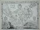
Imprint: London, 1772
360 x 420 mm., with accompanying text in good condition.
From Edmund Gibson's edition of Camden's 'Britannia'. Gibson announced that his maps engraved by Robert Morden utilised unpublished surveys where available and the knowledge of local gentlemen who supplied corrections. Morden was an accomplished bookseller and publisher who contributed a great deal to geography and cartography. Morden's maps were very popular. 'Britannia' was first published in 1695, and subsequently in 1722, c.1730, 1753 & 1772. Harvey & Thorpe 18; refer to Skelton no. 117.
Stock number:8339.
|
|

Imprint: London, 1695
Edition: First Edition 360 x 420 mm., faint mark upper right margin, otherwise in good condition.
Ex Edmund Gibson's edition of Camden's 'Britannia'. Gibson announced that his maps engraved by Robert Morden utilised unpublished surveys where available and the knowledge of local gentlemen who supplied corrections. Morden was an accomplished bookseller and publisher who contributed a great deal to geography and cartography. Morden's maps were very popular. 'Britannia' was first published in 1695, and subsequently in 1722, c.1730, 1753 & 1772. This is an example from the first edition. Skelton no. 117.
Stock number:5458.
|
|
|
Imprint: London, 1676-[1770]
95 x 60 mm., laid down as issued, in fine condition.
This pack was first announced by Robert Morden (fl.1669-1703) in the Easter Term Catalogues for 5 May 1676 and are otherwise undated. A second state was advertised in the Term Catalogues for October of the same year, 1676. This is identified by the presence of the names of neighbouring counties as here. For each county Morden displays below the map its Length, Breadth and Circumference in Old English miles. Below that he gives the chief city or town and its distance from London first in reputed and then measured miles according to John Ogilby. Lastly, he states their latitude. Each map bears the roads featured by Ogilby in his Britannia of 1675 with his leave, the main ones double lined and minor ones identified by one. Each bears a compass for bearing. In most cases, they are the first printed maps of the county to include roads, included within only six months of Ogilbys publication. This map of Worcestershire is from a rare later issue of Mordens playing cards entitled A Brief Description of England and Wales by Homan Turpin. The whereabouts of the plates since Morden last issued them is unknown, but they eventually came into Turpins possession. He was a bookseller from at least 1764 to 1787 who interestingly traded in second-hand books and buying libraries. The date of their issue is speculative as none of the six known Turpin catalogues list the cards it has been presumed to have been issued late in his career. Arber (1903-06) I. 263; Hodson no. 273; Mann & Kingsley Playing Cards, in Map Collector Series no. 87 p. 26, 3.3.
Stock number:9874.
|
|

Imprint: London, 1695
Edition: First Edition 360 x 420 mm., in good condition.
Ex Edmund Gibson's edition of Camden's 'Britannia'. Gibson announced that his maps engraved by Robert Morden utilised unpublished surveys where available and the knowledge of local gentlemen who supplied corrections. Morden was an accomplished bookseller and publisher who contributed a great deal to geography and cartography. Morden's maps were very popular. 'Britannia' was first published in 1695, and subsequently in 1722, c.1730, 1753 & 1772. This is an example from the first edition. Skelton no. 117.
Stock number:5459.
|
|

Imprint: Shrewsbury, William Morris, 1801
175 x 240 mm. Uncoloured.
Lewis Morris (1701-65) from his early twenties was employed as an estate surveyor in and around Anglesey many of which survive to this day in Bangor. In 1729 he was appointed Searcher and Customs Officer at Beaumaris and Holyhead. It is whilst employed here that he learnt of the poor quality of the charts of the island and coastline of Wales in general. At that time mariners were relying on those of Captain Greenville Collins published in the Great Britains Coasting Pilot from 1693. Although they were undoubtedly and advance at the time they were still inadequate and inaccurate. In 1735 he proposed to the Admiralty that he undertake a large scale survey of the Welsh coast. As is often the case he received little support. So he began surveying the island of Anglesey in 1737 using his own funds. With the help of his old employers influence at the Admiralty he managed to acquire the use of a vessel in 1739 to continue the work. Still his work received no official backing for publication so in 1748 he published the work privately.The Plans of Harbours, Bars, Bays and Roads in St. Georges Channel was an immediate success, there are no less than 1,247 individual subscribers listed. His son William (1758-1808) re-published the book in 1801 with entirely new engraved plates. Evans (1964). Maps of Wales and Welsh Cartographers, in Map Collectors Circle no. 13 pp. 11-12; Evans, Olwen Caradoc. (1969). Marine Plans and Charts of Wales, in Map Collectors Circle no. 54 pp. 28-31 no. 80; Morris, Rear Admiral R. O. (1998). Lewis Morris and his Plans in St. Georges Channel, in IMCoS Journal no. 74 pp. 45-50; NMM 402; Robinson (1979) 'Lewis Morris, Chartmaker Extraordinary', in The Map Collector no. 8 pp. 32-6; refer Shirley Atlases in the BL M.Morr 1a.
Stock number:2659.
|
|
|
Imprint: London, Lewis Morris, 1748
Oblong quarto (220 x 285 mm.), in original blue paper wrappers, spine worn, later box case with calf gilt title label. With ornate engraved title page, Preface, Index and Subscribers Names with Addenda, Observations, pp. iv, (8), 20, with 26 plates including the title (24 charts, 2 of which are folding).
Lewis Morris (1701-65) from his early twenties was employed as an estate surveyor in and around Anglesey many of which survive to this day in Bangor. In 1729 he was appointed Searcher and Customs Officer at Beaumaris and Holyhead. It is whilst employed here that he learnt of the poor quality of the charts of the island and coastline of Wales in general. At that time mariners were relying on those of Captain Greenville Collins published in the Great Britains Coasting Pilot from 1693. Although they were undoubtedly an advance at the time, they were still inadequate. In 1735 he proposed to the Admiralty that he undertake a large scale survey of the Welsh coast. As is often the case he received little support. So he began surveying the island of Anglesey in 1737 using his own funds. With the help of his old employer's influence at the Admiralty he managed to acquire the use of a vessel in 1739 to continue the work. Still his work received no official backing for publication, so in 1748 he published the work privately.The Plans of Harbours, Bars, Bays and Roads in St. Georges Channel was an immediate success, there are no less than 1,247 individual subscribers listed. The charts were considered a great improvement. The elaborate title is flanked either side by merchant and sailor, below are images of a shipwreck and one under safe passage in close quarters. The imprint below is dated 29 September 1748 and accompanied by a Psalm in Welsh. The plates were all engraved by Nathaniel Hill (fl. 1742-68).Booth (1977) pp. 94-5; Evans (1964). Maps of Wales and Welsh Cartographers, in Map Collectors Circle no. 13 pp. 11-12; Evans, Olwen Caradoc. (1969). Marine Plans and Charts of Wales, in Map Collectors Circle no. 54 pp. 28-29; Morris, Rear Admiral R. O. (1998). Lewis Morris and his Plans in St. Georges Channel, in IMCoS Journal no. 74 pp. 45-50; NMM 400; Robinson (1979) 'Lewis Morris, Chartmaker Extraordinary', in The Map Collector no. 8 pp. 32-6; Shirley Atlases in the BL M.Morr 1a; Worms & Baynton-Williams (2011).
Stock number:9763.
|
|
|
Imprint: Shrewsbury, 1801
Quarto (305 x 220 mm.), later quarter calf, embossed titles to spine, protecting the original blue paper wrappers, with typographic title page, Dedication, Preface and List of Subscribers followed by a list of Officers in His Majesty's Navy, Observations, pp. xii, 21, and 32 engraved charts consisting of one large folding one and 3 other folding charts, uncut, some light dampstaining, otherwise in good condition.
Lewis Morris (1701-65) from his early twenties was employed as an estate surveyor in and around Anglesey, many of which survive to this day in Bangor. In 1729 he was appointed Searcher and Customs Officer at Beaumaris and Holyhead. It is whilst employed here that he learnt of the poor quality of the charts of the island and coastline of Wales in general. At that time mariners were relying on those of Captain Greenville Collins published in the Great Britains Coasting Pilot from 1693. Although they were undoubtedly an advance at the time, they were still inadequate and inaccurate. In 1735 he proposed to the Admiralty that he undertake a large scale survey of the Welsh coast. As is often the case he received little support. So he began surveying the island of Anglesey in 1737 using his own funds. With the help of his old employer's influence at the Admiralty he managed to acquire the use of a vessel in 1739 to continue the work. Still his work received no official backing for publication so, in 1748 he published the work privately.The Plans of Harbours, Bars, Bays and Roads in St. Georges Channel was an immediate success, there are no less than 1,247 individual subscribers listed. His son William (1758-1808) re-published the book offered here in 1801 with entirely new engraved plates. There are also some entirely new plates including one large folding one of Liverpool and Chester, and another of Dublin. The dedication to the Lords Commissioners is dated Aberystwith, 1 June 1801. Notable names listed amongst the subscribers is Alexander Dalrymple and William Faden, the publisher who ordered 20 copies, Evans (1964). Maps of Wales and Welsh Cartographers, in 'Map Collectors Circle' no. 13 pp. 11-12; Evans, Olwen Caradoc. (1969). Marine Plans and Charts of Wales, in 'Map Collectors Circle' no. 54 pp. 28-31 no. 102; Morris, Rear Admiral R. O. (1998). Lewis Morris and his Plans in St. Georges Channel, in 'IMCoS Journal' no. 74 pp. 45-50; NMM 402; Robinson (1979) 'Lewis Morris, Chartmaker Extraordinary', in 'The Map Collector' no. 8 pp. 32-6; refer Shirley Atlases in the BL M.Morr 1a.
Stock number:9764.
|
|

Imprint: London, John Stockdale, 1792
Octavo (220 x 145 mm.), full modern calf, gilt ruled ribbed spine with calf gilt title label. With two large folding maps and a folding table, in good condition. xvi, 536 pp.
This is the second edition published in London of a work first published in Elizabethtown in 1789. Jedidiah Morse (1761-1826) was born in Woodstock, Connecticut, and became a Congregational Minister and geographer in New Haven. His book The American Geography was first published in 1784 with text only and its success earned him the title of the father of American geography. The two engraved maps depict the northern and southern parts of the fledgling United States of America. That of the northern parts is entitled A Map of the Northern and Middle States; comprehending the Western Territory and the British Dominions in North America from the best Authorities. The map of the southern parts is entitled A Map of the States of Virginia, North Carolina, South Carolina and Georgia; Comprehending the Spanish Provinces of East and West Florida ... and is by Joseph Purcell of particular interest including as it does a reference to the New State of Franklin. This State existed effectively as a Republic for four years or more from 1784 and was intended as part payment to the Federal Government of debts accrued by North Carolina during the American War of Independence. The map also interestingly outlines the locations of the Indian nations at the time. Provenance: acquired in Texas 1999. Howes (1962) M840; Ristow (1985) p. 71; Sabin (1868) 50926; Schwartz & Ehrenberg (1980) p. 209.
Stock number:7142.
|
|
|
Imprint: Elizabeth Town, Printed by Shepard Kollock, for the Author, 1789
Octavo (200 x 120 mm.), full contemporary tree calf, gilt ruled ribbed spine with ornate gilt red calf title label. With typographic title page, pp. xii, 534, (4), with two large folding maps, the second map with some early closed tears to fold, some general toning as is usual, otherwise in good condition.
The FIRST AMERICAN GEOGRAPHIC WORK TO CONTAIN MAPS. Jedidiah Morse (1761-1826) was born in Woodstock, Connecticut, and became a Congregational Minister and geographer in New Haven. His book The American Geography was first published in 1784 with text only and its success earned him the title of the father of American geography.Prior to the Revolution, atlases were made in Europe and most of those used in the United States were published in England or France, although some of the individual maps, especially of the states, were drawn by local cartographers. This situation was due in part to the lack of skilled craftsmen and limited tools and equipment. Even locally produced paper in the colonial period was of poor quality. By the end of the Revolution the situation had changed and a number of elements had combined which permitted American commercial atlas publishing to develop and flourish (Tyner). She went on to identify five reasons; Independence, Exploration, Development of statistics as a field, National censuses and the Rise of thematic cartography.Early American cartographic works were geographical texts, only some of which contained any maps. One of the first to do so was this work by Morse published in 1789. It should be pointed out that in the same year Christopher Colles published his Survey of the Roads of the United States of which according to Schwartz and Ehrenberg only 15 copies survive. The American Geography covered the western hemisphere. In 1793 a second volume covering the eastern hemisphere was published. The two were then issued as the American Universal Geography in 1793. The premise of the book was laid out in the Preface where he states So imperfect are all the accounts of America hitherto published, even by those who once exclusively possessed the best means of information
But since the United State[sic] have become an independent nation, and have risen into Empire, it would be reproachful for them to suffer this ignorance to continue
To furnish this has been the design of the author. The two final leaves contain the errata and Corrections respecting France.To illustrate the work are two important maps. The Preface introduces them; It is to be regretted, that so few Maps could be introduced into the work; but the author hopes to be enabled to increase the number in future editions. The Map of the southern states, was compiled from original and authentic documents, by Mr. joseph Purcell, of Charleston, South Carolina, a Gentleman fully equal to the undertaking
The Map of the northern states was compiled principally by the Engraver [Amos Doolittle]. Both maps were engraved by Doolittle (1754-1832), like many engravers of his day he was apprenticed to a silversmith. He is most famous for his series of engravings of the battles of Lexington and Concord in 1775. The southern map is of interest as it includes a reference to the New State of Franklin. This State has a curious history. It was first offered as compensation to Congress by North Carolina in 1784 to help pay off debts from the American War of Independence. When the offer was not taken up it effectively seceded from the state on 23 August 1784 at a meeting held in Jonesborough. The idea was to eventually become the fourteenth state of the Union. It was effectively a Republic for four and a half years until early in 1789 North Carolina assumed control again. Provenance: Manuscript ownership of Isaac Lathrops 1789 on the title page; Robert Rulon-Miller, 1998; private collection. ADNB; Brown, Ralph (1941) The American Geographies of Jedidiah Morse; ESTC W31207; Evans 21978; Howes (1962) M840; Ristow (1985) p. 71; Sabin (1868) 50924; Schwartz & Ehrenberg (1980) p. 209; Tyner, Judith (1989) Development of the American Atlas: 1790-1980 pp. 1-2; Wheat & Brun 1985) nos. 149 & 491.
Stock number:9896.
|
|
Imprint: London, c.1840
19 x 25.5 cms. Uncoloured. Light foxmark upper left.
ex 'Barclay's Dictionary'. Moule (1784-1851) was a noted historian, map seller and publisher. His finest work is the 'English Counties Delineated' first published in 1837. The publisher was George Virtue who used the same beautiful plates in his publication of Rev. James Barclay's 'Dictionary'. The maps are considered the most attractive of all the later English county maps.
Stock number:2545.
|
|

Imprint: London, 1840
245 x 185 mm., one or two light foxmarks otherwise in good condition.
From 'Barclay's Dictionary'. Moule (1784-1851) was a noted historian, map seller and publisher. His finest work is the 'English Counties Delineated' first published in 1837. The publisher was George Virtue who used the same beautiful plates in his publication of Rev. James Barclay's 'Dictionary'. The maps are considered the most attractive of all the later English county maps. This plan of Oxford is engraved by James Bingley is attractively decorated with heraldic arms of the city, and the various University Colleges along with views of Christchurch College and Oxford itself.
Stock number:8920.
|
|

Imprint: London, 1840
245 x 185 mm., in attractive recent colour, in good condition.
From 'Barclay's Dictionary'. Moule (1784-1851) was a noted historian, map seller and publisher. His finest work is the 'English Counties Delineated' first published in 1837. The publisher was George Virtue who used the same beautiful plates in his publication of Rev. James Barclay's 'Dictionary'. The maps are considered the most attractive of all the later English county maps. This plan of Oxford is engraved by James Bingley is attractively decorated with heraldic arms of the city, and the various University Colleges along with views of Christchurch College and Oxford itself.
Stock number:8940.
|
|