|
|

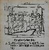
Imprint: London, c.1840
19 x 25.5 cm. Uncoloured
ex 'Barclay's Dictionary'. Moule (1784-1851) was a noted historian, map seller and publisher. His finest work is the 'English Counties Delineated' first published in 1837. The publisher was George Virtue who used the same beautiful plates in his publication of Rev. James Barclay's 'Dictionary'. The maps are considered the most attractive of all the later English county maps.
Stock number:2554.
|
|

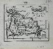
Imprint: London, 1831
20 x 25.5 cms. In modern outline colour? With two mild paper creases, and a marginal tear repaired just effecting the image
First state. Thomas Moule (1784-1851) was a noted historian, map seller and publisher. His finest work is the "English Counties Delineated" first published in 1837. The publisher was George Virtue who used the same beautiful plates in his publication of Rev. James Barclay's "Dictionary". The maps are considered the most attractive of all the later English county maps. Here in its first state with the imprint of the engraver W. Schmollinger, before the hundreds panel gets shaded. Hodson 94.1
Stock number:3516.
|
|

Imprint: London, 1837
205 x 260 mm., in full early wash colour, in very good condition.
Thomas Moule (1784-1851) was a noted historian, mapseller and publisher. His finest work is the 'English Counties Delineated' first published in 1837 following its issue in parts from May 1830 to the spring of 1836. The publisher was George Virtue who used the same beautiful plates later in his publication of Rev. James Barclays 'Dictionary'. The maps are considered the most attractive of all the later English county maps. They are embellished with topographical views, coats of arms and decorative borders. They were engraved by James Bingley (1796-1869), John Crane Dower (1791?-1847) and William Schmollinger (fl.1830-37). Bingley was born in Leicester and was in London by 1820 when he married in Chelsea. He was imprisoned for debt in 1833 at which time he was in partnership with Schmollinger. Thomas Moule wrote books on heraldry and antiquities. From 1816-23 he was a bookseller in Duke Street, Grosvenor Square, London. He was then employed in the General Post Office to 'interpret illegible addresses' (BBTI) whilst also working as Chamber-Keeper in the Lord Chamberlain's Department. The last position gave him a residence at St. James's Palace where he died in 1851. After the completion of the parts issue sometime in 1836 the 'English Counties Delineated' appeared as a two-volume book in 1837 with subsequent editions in 1838 and 1839. This second state of the map of Surrey bears the imprint of Bingley below, it is rare. British Book Trade Index; Campbell (1985b); Carroll (1996) 95; Chubb (1927) 472; Worms & Baynton-Williams (2011).
Stock number:9328.
|
|
|
Imprint: London, George Virtue, 26, Ivy Lane Paternoster Row, 1839
Edition: First Edition Binding: Hardback Quarto, 2 volumes (275 x 220 mm. each), contemporary half calf, marbled paper boards, blind ruled, spine with raised bands, each compartment with ornate gilt panelling and central feature, calf gilt title and volume labels, lower board of first volume loose, marbled endpapers. With engraved frontispiece of Queen Victoria bearing title, further engraved title page with vignette of Greenwich Hospital, typographic title page, pp. xxiv, 484; typographic title, pp. (2), 582, with 56 maps on 59 plates (comprising 2 general on 5 plates, 42 counties, 7 town plans, 3 islands and 2 of London) of which 2 are folding and 2 engravings, some maps trimmed slightly and light foxing as is always the case, otherwise a good example.
FIRST EDITION. Thomas Moule (1784-1851) was a noted historian, mapseller and publisher. His finest work is this, the English Counties Delineated, first published in 1837 following its issue in parts from May 1830 to the spring of 1836. The publisher was George Virtue (1793-1868) who used the same beautiful plates later in his publication of Rev. James Barclayâs Dictionary. The maps are considered the most attractive of all the later English county maps. They are embellished with topographical views, coats of arms and decorative borders. They were engraved by James Bingley (1796-1869), John Crane Dower (1791?-1847) and William Schmollinger (fl.1830-37). Bingley was born in Leicester and was in London by 1820, when he married in Chelsea. He was imprisoned for debt in 1833 at which time he was in partnership with Schmollinger. Dower was born in London and left a son John James Dower who was also an engraver. Schmollinger was also declared bankrupt in 1856. 'One of the earliest atlases to show the beginnings of the railway network that was to cover Great Britain' (Wardington Catalogue).Thomas Moule wrote books on heraldry and antiquities. From 1816-23 he was a bookseller in Duke Street, Grosvenor Square, London. He was then employed in the General Post Office to 'interpret illegible addresses' (BBTI), whilst also working as Chamber-Keeper in the Lord Chamberlain's Department. The last position gave him a residence at St. James's Palace where he died in 1851. After the completion of the parts issue sometime in 1836, the English Counties Delineated appeared as a two-volume book in 1837, with subsequent editions in 1838 and 1839 (as here). The first edition included a frontispiece portrait of William IV, indicating its most likely publication before his death on 20 June 1837. This includes the portrait of the young Queen Victoria. Several pages of descriptive text accompany each county map. A large index ends volume two. British Book Trade Index; Campbell (1985b); Carroll (1996) 95; Chubb (1927) 472; Sotheby's Wardington sale 10 October 2006 lot 308; Worms & Baynton-Williams (2011).
Stock number:10298.
|
|
|
Imprint: London, 1837
Edition: First Edition Binding: Hardback Quarto, 2 volumes (265 x 210 mm. each), full contemporary diced russia calf, rebacked with raised bands, blind ruled compartments and dark green calf labels bearing gilt volume numbers and titles. With engraved frontispiece of King William IV bearing title, further engraved title page with vignette of Greenwich Hospital, typographic title page, pp. xxiv, 484; typographic title, pp. (2), 582, with 1 steel engraved view of Canterbury Cathedral and 58 maps mostly of English counties, all in EARLY WASH COLOUR, England trimmed and backed on cloth, Inland navigation consisting of 4 plates, Metropolitan Boroughs backed on linen, Norfolk with small tear repaired, Suffolk with binders tear repaired, Somerset folding, Yorkshire North Riding folding. Some maps trimmed slightly as is always the case, otherwise a very good example.
FIRST EDITION. Thomas Moule (1784-1851) was a noted historian, mapseller and publisher. His finest work is this, the English Counties Delineated, first published in 1837 following its issue in parts from May 1830 to the spring of 1836. The publisher was George Virtue (1793-1868) who used the same beautiful plates later in his publication of Rev. James Barclayâs Dictionary. The maps are considered the most attractive of all the later English county maps. They are embellished with topographical views, coats of arms and decorative borders. They were engraved by James Bingley (1796-1869), John Crane Dower (1791?-1847) and William Schmollinger (fl.1830-37). Bingley was born in Leicester and was in London by 1820, when he married in Chelsea. He was imprisoned for debt in 1833 at which time he was in partnership with Schmollinger. Dower was born in London and left a son John James Dower who was also an engraver. Schmollinger was also declared bankrupt in 1856. 'One of the earliest atlases to show the beginnings of the railway network that was to cover Great Britain' (Wardington Catalogue).Thomas Moule wrote books on heraldry and antiquities. From 1816-23 he was a bookseller in Duke Street, Grosvenor Square, London. He was then employed in the General Post Office to 'interpret illegible addresses' (BBTI), whilst also working as Chamber-Keeper in the Lord Chamberlain's Department. The last position gave him a residence at St. James's Palace where he died in 1851. After the completion of the parts issue sometime in 1836, the English Counties Delineated appeared as a two-volume book in 1837, with subsequent editions in 1838 and 1839. The first edition offered here includes a frontispiece portrait of William IV, indicating its most likely publication before his death on 20 June 1837. Later issues include a portrait of the young Queen Victoria. Several pages of descriptive text accompany each county map. A large index ends volume two. A fine example of the work with all the maps in the preferred early wash colour state. Provenance: 'Ex Libris Thomae Rymer' bookplate pasted inside covers; Doreen Green collection; Clive A. Burden Ltd. Catalogue 14 (2017) item 67; private English Collection. British Book Trade Index; Campbell (1985); Carroll (1996) 95; Chubb (1927) 472; Sotheby's Wardington sale 10 October 2006 lot 308; Worms & Baynton-Williams (2011).
Stock number:10297.
|
|

Imprint: London, c.1730
430 x 520 mm., modern outline colour, a light fox mark in the sea otherwise in very good condition.
A fine early chart depicting the south west coast of the Iberian peninsula. It extends from Cape St. Vincent in Portugal along the Algarve region to Spain taking in Cadiz and Cape Trafalger. A large scale inset depicts the Bay of Cadiz and details the town. It appeared in the 'English Pilot Southern Navigation'. The title is set within a hung drape below the scale of Leagues. Shirley BL M.M&P-1a 26.
Stock number:5386.
|
|

Imprint: London, W & J Mount and T. Page at the Postern on Tower Hill, 1749
515 x 1035 mm., two sheets joined as one, minor margin repair at the outer edge of upper centre fold, not affecting the map, otherwise in good condition.
This chart of the east coast of England extending from Newcastle to the Thames Estuary. It focuses on the Newcastle Trade or the shipment of coal from the north east to the city of London and the south east. Insets illustrate the Falmouth Sands, Harwich and a more detailed coastal chart of the area from Sunderland to Blyth. It was published in Mount & Page's 'English Pilot First Part' covering the Southern Navigation and was included from at least 1729. Shirley 'Atlases in the BL' M.M&P 1b no. 2.
Stock number:8556.
|
|

Imprint: London, W & J Mount and T. Page at the Postern on Tower Hill, 1729-[49]
445 x 545 mm., in good condition.
A sea chart of the Cape Verde Islands first published by William Mount and Thomas Page from at least 1729 in the 'English Pilot First Part, Southern Navigation'. It's earlier issue was actually by John Seller. This handsome chart illustrates an important location to the Atlantic trade routes. The chart is embellished with a decorative title cartouche, large central compass rose and rhumb lines. Shirley (BL Atlases) M.M&P-1b no. 24.
Stock number:8573.
|
|

Imprint: London, W & J Mount and T. Page at the Postern on Tower Hill, c.1736-[47]
405 x 525 mm., in very good condition.
This very rare English sea chart was possibly first published in Mount and Page's 'English Pilot Third Part' covering the Mediterranean Sea from 1736. This example was issued in 1747. It focuses on the Mediterranean islands of Corsica and Sardinia and draws on the cartography of Henri Michelot and Laurent Bremond as stated in the title. Michelot was a hydrographer and pilot and Bremond a hydrographer, both at Marseilles. They worked together on 'Recueil de plusiers Plans des ports et Rades de la Mer Mediterranee' published in Marseilles 1721. NMM 425 no. 150?; Shirley 'Atlases in the BL' M.M&P 7c no. 11.
Stock number:8583.
|
|

Imprint: London, W & J Mount and T. Page at the Postern on Tower Hill, 1715-[49]
470 x 530 mm., with a double fold as issued in the atlas, upper corner repairs and margins of second folds all superbly restored, otherwise in excellent condition.
A rare sea chart of Scotland first published by Mount and Page in the 'English Pilot First Part, Southern Navigation' in 1715. It extends to the north to include the Outer Hebrides, the Orkney Islands and the Shetland Islands. An inset features 'A Plan of Holy Island and the Staples'. All of the major ports, harbours and castles are featured along the coasts, with as might be expected no inland details given. Soundings are shown along the east coast in the Firth of Forth north to Dundee along with a few others. The title helps to fill the blank area of the mainland. A later second state exists with a new title cartouche in the sea upper right. Moir (1983) II p. 12; NMM 423 no. 89; Shirley 'Atlases in the BL' M.M&P 1b no. 3.
Stock number:8557.
|
|

Imprint: London, c.1735
410 x 520 mm. Small split lower centrefold just affecting the image, repaired. In good condition.
A fine uncommon sea chart of the Mediterranean waters of southern France. They extend from the Spanish border to San Remo in Italy. An inset features the Bay of Toulon. Shirley BL M.M&P-3b 14.
Stock number:3864.
|
|

Imprint: London, W & J Mount and T. Page at the Postern on Tower Hill, 1727-[47]
410 x 520 mm., with a couple of small marks on the right side, otherwise okay.
This very rare chart is quite probably the work of the engraver Samuel Parker. It depicts southern France and includes part of Spain and Italy including San Remo. It displays an inset of the Bay of Toulon and appears in Mount & Page's 'English Pilot Part Three' covering the Mediterranean Sea in 1747. Shirley 'Atlases in the BL' M.M&P 3b no. 14.
Stock number:8582.
|
|

Imprint: London, W & J Mount and T. Page at the Postern on Tower Hill, 1729-[49]
375 x 480 mm., in very good condition.
A sea chart of the Western Isles first published by William Mount and Thomas Page from at least 1729 in the 'English Pilot First Part, Southern Navigation'. A sea chart focusing on the Azores. The title and distance scales enclosed in simple cartouches and two compass roses make it a handsome chart. Phillips (A) #5179-29; Shirley 'Atlases in the BL' M.M&P 1b no. 23.
Stock number:8572.
|
|

Imprint: Ulm, 1692-[c.1703]
80 x 65 mm., in fine condition on thick paper.
In 1692 Johann Ulrich Müller (1633-1715) published a small geographical work entitled 'Geographia Totius Orbis Compendiaria'. It appears the maps were engraved by a member of the Bodenehr family. This example is from the virtually unrecorded smaller format edition published by Gabriel Bodenehr entitled 'Atlas Minor sive Orbis Terrae'. No date is to be found on the title but c.1703 is presumed. The map depicts Egypt and the River Nile. Refer to King (2003) pp. 25 & 160B1; Phillips (1909-) no. 512; Shirley (2004) T.Mull-1a no. 74.
Stock number:4852.
|
|

Imprint: Ulm, 1692-[c.1703]
65 x 80 mm., with mild waterstain in left margin, otherwise in fine condition on thick paper.
In 1692 Johann Ulrich Müller (1633-1715) published a small geographical work entitled 'Geographia Totius Orbis Compendiaria'. It appears the maps were engraved by a member of the Bodenehr family. This example is from the virtually unrecorded smaller format edition published by Gabriel Bodenehr entitled 'Atlas Minor sive Orbis Terrae'. No date is to be found on the title but c.1703 is presumed. The map depicts Upper Egypt, Nubia and the Upper River Nile. Refer to King (2003) pp. 25 & 160B1; Phillips (1909-) no. 512; Shirley (2004) T.Mull-1a no. 74.
Stock number:7664.
|
|

Imprint: Ulm, 1692-[1702]
70 x 80 mm., in good condition.
In 1692 Johann Ulrich Müller (1633-1715) published a small geographical work entitled "Geographia Totius Orbis Compendiaria". To illustrate both works Müller provided a new series of 103 maps. Mostly unsigned, it would seem that the engraver was one of the Bodenehr family. G. C. Bodenehr signs the engraved frontispiece. Tooley's 'Dictionary of Mapmakers' declares the relationships between the various Bodenehrs of the period have not been determined and identifies three G. Bodenehrs. Gabriel, elder and younger, and Georg Conrad (1663-1710), who may well be our engraver. Other authorities assign them to one of the Gabriels.A further expanded edition was published in 1702, under the title 'Neu=aussgefertiger Kleiner Atlas' in Ulm by Georg W. Kuehnen offered here, and in Frankfurt by Johann Philipp Andrea. These later expanded editions are rare, only the Wardington example has been recorded at auction since 1993. The map depicts Egypt and the River Nile. Gabriel Bodenehr is entitled Atlas Minor sive Orbis Terrae. Refer to King (2003) pp. 25 & 160B1; Phillips (1909-) no. 512; Shirley (2004) T.Mull-1a; Tooleys 'Dictionary'.
Stock number:7666.
|
|

Imprint: Ulm, 1692-[1702]
70 x 80 mm., in good condition.
In 1692 Johann Ulrich Müller (1633-1715) published a small geographical work entitled "Geographia Totius Orbis Compendiaria". To illustrate both works Müller provided a new series of 103 maps. Mostly unsigned, it would seem that the engraver was one of the Bodenehr family. G. C. Bodenehr signs the engraved frontispiece. Tooley's 'Dictionary of Mapmakers' declares the relationships between the various Bodenehrs of the period have not been determined and identifies three G. Bodenehrs. Gabriel, elder and younger, and Georg Conrad (1663-1710), who may well be our engraver. Other authorities assign them to one of the Gabriels.A further expanded edition was published in 1702, under the title 'Neu=aussgefertiger Kleiner Atlas' in Ulm by Georg W. Kuehnen offered here, and in Frankfurt by Johann Philipp Andrea. These later expanded editions are rare, only the Wardington example has been recorded at auction since 1993. The map depicts Upper Egypt, Nubia and the Upper River Nile. Gabriel Bodenehr is entitled Atlas Minor sive Orbis Terrae. Refer to King (2003) pp. 25 & 160B1; Phillips (1909-) no. 512; Shirley (2004) T.Mull-1a; Tooleys 'Dictionary'.
Stock number:7667.
|
|

Imprint: Ulm, 1692-[c.1703]
80 x 65 mm., with mild waterstain in the lower margin, otherwise in fine condition on thick paper.
In 1692 Johann Ulrich Müller (1633-1715) published a small geographical work entitled 'Geographia Totius Orbis Compendiaria'. It appears the maps were engraved by a member of the Bodenehr family. This example is from the virtually unrecorded smaller format edition published by Gabriel Bodenehr entitled 'Atlas Minor sive Orbis Terrae'. No date is to be found on the title but c.1703 is presumed. The map depicts Egypt and the River Nile. Refer to King (2003) pp. 25 & 160B1; Phillips (1909-) no. 512; Shirley (2004) T.Mull-1a no. 74.
Stock number:7665.
|
|
Imprint: Ulm, 1692-[1702]
70 x 80 mm., in good condition.
In 1692 Johann Ulrich Müller (1633-1715) published a small geographical work entitled "Geographia Totius Orbis Compendiaria". To illustrate both works Müller provided a new series of 103 maps. Mostly unsigned, it would seem that the engraver was one of the Bodenehr family. G. C. Bodenehr signs the engraved frontispiece. Tooley's 'Dictionary of Mapmakers' declares the relationships between the various Bodenehrs of the period have not been determined and identifies three G. Bodenehrs. Gabriel, elder and younger, and Georg Conrad (1663-1710), who may well be our engraver. Other authorities assign them to one of the Gabriels.A further expanded edition was published in 1702, under the title 'Neu=aussgefertiger Kleiner Atlas' in Ulm by Georg W. Kuehnen offered here, and in Frankfurt by Johann Philipp Andrea. These later expanded editions are rare, only the Wardington example has been recorded at auction since 1993. The map depicts Egypt and the River Nile. Gabriel Bodenehr is entitled Atlas Minor sive Orbis Terrae. Refer to King (2003) pp. 25 & 160B1; Phillips (1909-) no. 512; Shirley (2004) T.Mull-1a; Tooleys 'Dictionary'.
Stock number:7668.
|
|
Imprint: Ulm, 1692-[c.1703]
65 x 80 mm., light waterstain upper left margin, otherwise in good condition on thick paper.
In 1692 Johann Ulrich Müller (1633-1715) published a small geographical work entitled 'Geographia Totius Orbis Compendiaria'. It appears the maps were engraved by a member of the Bodenehr family. This example is from the virtually unrecorded smaller format edition without text on the page published by Gabriel Bodenehr entitled 'Atlas Minor sive Orbis Terrae'. No date is to be found on the title but c.1703 is presumed. The map depicts Dutch Guiana in South America. Refer to King (2003) pp. 25 & 160B1; refer Phillips (1909-) no. 512; refer Shirley (2004) T.Mull-1a.
Stock number:7891.
|
|