|
|

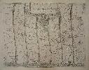
Imprint: London, 1675
345 x 445 mm. Uncoloured. Some creasing along centrefold, and some foxing.
John Ogilby's seminal work was entitled 'Britannia, Volume the First. Or An Illustration of the Kingdom of England and Dominion of Wales: by A Geographical and Historical Description of the Principal Roads Thereof'. It was the first national road-atlas of any country in Western Europe and a landmark in the mapping of England and Wales. Ogilby (16001676) had a remarkable life and arguably its finest achievement published just before his death the following year is the 'Britannia'. The 100 double-page engraved road maps were composed of maps of seventy-three major roads and cross-roads, presented in a continuous strip-form. For the first time in England, the atlas was prepared on a uniform scale, at one inch to a mile, based on the statute mile of 1,760 yards to the mile. Ogilby claimed that 26,600 miles of roads were surveyed in the course of preparing the atlas, but only about 7,500 were actually depicted in print. "In its comprehensiveness, its incorporation of new devices of computation and delineation, and its opulence of paper, design and decoration, it immediately set a new standard for map-making in England ... this volume was an attempt at a scientific study not only of the roads but also the terrain and habitations on either side of the roads" (K.S. Eerde, John Ogilby and the Taste of his Times, 1976, p.137). This sheet is plate 75 in its numbered state with ornate title cartouche. The map shows the road from Kings Lynn in Norfolk to Harwich in Suffolk and includes the city of Ipswich lower right. Chubb C; Shirley, British Library T.OGIL-4a; Wing O168.
Stock number:2689.
|
|

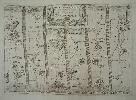
Imprint: London, 1675
330 x 445 mm., light print offset extreme lower right corner, otherwise in good condition.
John Ogilby's seminal work was entitled 'Britannia, Volume the First. Or An Illustration of the Kingdom of England and Dominion of Wales: by A Geographical and Historical Description of the Principal Roads Thereof'. It was the first national road-atlas of any country in Western Europe and a landmark in the mapping of England and Wales. Ogilby (16001676) had a remarkable life and arguably its finest achievement published just before his death the following year is the 'Britannia'. The 100 double-page engraved road maps were composed of maps of seventy-three major roads and cross-roads, presented in a continuous strip-form. For the first time in England, the atlas was prepared on a uniform scale, at one inch to a mile, based on the statute mile of 1,760 yards to the mile. Ogilby claimed that 26,600 miles of roads were surveyed in the course of preparing the atlas, but only about 7,500 were actually depicted in print. "In its comprehensiveness, its incorporation of new devices of computation and delineation, and its opulence of paper, design and decoration, it immediately set a new standard for map-making in England ... this volume was an attempt at a scientific study not only of the roads but also the terrain and habitations on either side of the roads" (K.S. Eerde, 'John Ogilby and the Taste of his Times', 1976, p.137). This sheet is plate 16 in its numbered state with ornate title cartouche. The map shows Monmouth, Newport and Cardiff. Chubb C; Shirley, British Library T.OGIL-4a; Wing O168.
Stock number:6025.
|
|

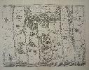
Imprint: London, 1675
350 x 460 mm., a fine engraving in good condition.
John Ogilby's seminal work was entitled 'Britannia, Volume the First. Or An Illustration of the Kingdom of England and Dominion of Wales: by A Geographical and Historical Description of the Principal Roads Thereof'. It was the first national road-atlas of any country in Western Europe and a landmark in the mapping of England and Wales. Ogilby (16001676) had a remarkable life and arguably its finest achievement published just before his death the following year is the 'Britannia'. The 100 double-page engraved road maps were composed of maps of seventy-three major roads and cross-roads, presented in a continuous strip-form. For the first time in England, the atlas was prepared on a uniform scale, at one inch to a mile, based on the statute mile of 1,760 yards to the mile. Ogilby claimed that 26,600 miles of roads were surveyed in the course of preparing the atlas, but only about 7,500 were actually depicted in print. "In its comprehensiveness, its incorporation of new devices of computation and delineation, and its opulence of paper, design and decoration, it immediately set a new standard for map-making in England ... this volume was an attempt at a scientific study not only of the roads but also the terrain and habitations on either side of the roads" (K.S. Eerde, 'John Ogilby and the Taste of his Times', 1976, p.137). This sheet is plate 24 in its numbered state with ornate title cartouche. The map shows Chester in the lower left corner, Denbigh, Conway and Holy=head. Chubb C; Shirley, British Library T.OGIL-4a; Wing O168.
Stock number:6026.
|
|

Imprint: London, 1675
345 x 450 mm., a fine engraving in good condition.
John Ogilby's seminal work was entitled 'Britannia, Volume the First. Or An Illustration of the Kingdom of England and Dominion of Wales: by A Geographical and Historical Description of the Principal Roads Thereof'. It was the first national road-atlas of any country in Western Europe and a landmark in the mapping of England and Wales. Ogilby (16001676) had a remarkable life and arguably its finest achievement published just before his death the following year is the 'Britannia'. The 100 double-page engraved road maps were composed of maps of seventy-three major roads and cross-roads, presented in a continuous strip-form. For the first time in England, the atlas was prepared on a uniform scale, at one inch to a mile, based on the statute mile of 1,760 yards to the mile. Ogilby claimed that 26,600 miles of roads were surveyed in the course of preparing the atlas, but only about 7,500 were actually depicted in print. "In its comprehensiveness, its incorporation of new devices of computation and delineation, and its opulence of paper, design and decoration, it immediately set a new standard for map-making in England ... this volume was an attempt at a scientific study not only of the roads but also the terrain and habitations on either side of the roads" (K.S. Eerde, 'John Ogilby and the Taste of his Times', 1976, p.137). This sheet is plate 34 in its numbered state with ornate title cartouche. The map shows both Padstow and Truro. Chubb C; Shirley, British Library T.OGIL-4a; Wing O168.
Stock number:6028.
|
|

Imprint: London, 1675
350 x 445 mm., small hole repair on lower left neatline otherwise in good condition.
John Ogilby's seminal work was entitled 'Britannia, Volume the First. Or An Illustration of the Kingdom of England and Dominion of Wales: by A Geographical and Historical Description of the Principal Roads Thereof'. It was the first national road-atlas of any country in Western Europe and a landmark in the mapping of England and Wales. Ogilby (16001676) had a remarkable life and arguably its finest achievement published just before his death the following year is the 'Britannia'. The 100 double-page engraved road maps were composed of maps of seventy-three major roads and cross-roads, presented in a continuous strip-form. For the first time in England, the atlas was prepared on a uniform scale, at one inch to a mile, based on the statute mile of 1,760 yards to the mile. Ogilby claimed that 26,600 miles of roads were surveyed in the course of preparing the atlas, but only about 7,500 were actually depicted in print. "In its comprehensiveness, its incorporation of new devices of computation and delineation, and its opulence of paper, design and decoration, it immediately set a new standard for map-making in England ... this volume was an attempt at a scientific study not only of the roads but also the terrain and habitations on either side of the roads" (K.S. Eerde, 'John Ogilby and the Taste of his Times', 1976, p.137). This sheet is plate 67 in its numbered state with ornate title cartouche.Chubb C; Shirley, British Library T.OGIL-4a; Wing O168.
Stock number:6030.
|
|

Imprint: London, 1675
31 x 43 cms., later wash colour on lightly toned paper
John Ogilby's seminal work was entitled 'Britannia, Volume the First. Or An Illustration of the Kingdom of England and Dominion of Wales: by A Geographical and Historical Description of the Principal Roads Thereof'. It was the first national road-atlas of any country in Western Europe and a landmark in the mapping of England and Wales. Ogilby (16001676) had a remarkable life and arguably its finest achievement published just before his death the following year is the 'Britannia'. The 100 double-page engraved road maps were composed of maps of seventy-three major roads and cross-roads, presented in a continuous strip-form. For the first time in England, the atlas was prepared on a uniform scale, at one inch to a mile, based on the statute mile of 1,760 yards to the mile. Ogilby claimed that 26,600 miles of roads were surveyed in the course of preparing the atlas, but only about 7,500 were actually depicted in print. In its comprehensiveness, its incorporation of new devices of computation and delineation, and its opulence of paper, design and decoration, it immediately set a new standard for map-making in England ... this volume was an attempt at a scientific study not only of the roads but also the terrain and habitations on either side of the roads (K.S. Eerde, John Ogilby and the Taste of his Times, 1976, p.137). This sheet is plate 1 in its numbered state and one of just four desirable images depicting a waywiser in the title cartouche. The map shows the road from London to Islip and Oxford. Chubb C; Shirley, British Library T.OGIL-4a; Wing O168.
Stock number:3570.
|
|

Imprint: London, 1675
345 x 455 mm., in modern outline colour but in fine early red ruling, in good condition.
John Ogilby's seminal work was entitled 'Britannia, Volume the First. Or An Illustration of the Kingdom of England and Dominion of Wales: by A Geographical and Historical Description of the Principal Roads Thereof'. It was the first national road-atlas of any country in Western Europe and a landmark in the mapping of England and Wales. Ogilby (16001676) had a remarkable life and arguably its finest achievement published just before his death the following year is the 'Britannia'. The 100 double-page engraved road maps were composed of maps of seventy-three major roads and cross-roads, presented in a continuous strip-form. For the first time in England, the atlas was prepared on a uniform scale, at one inch to a mile, based on the statute mile of 1,760 yards to the mile. Ogilby claimed that 26,600 miles of roads were surveyed in the course of preparing the atlas, but only about 7,500 were actually depicted in print. "In its comprehensiveness, its incorporation of new devices of computation and delineation, and its opulence of paper, design and decoration, it immediately set a new standard for map-making in England ... this volume was an attempt at a scientific study not only of the roads but also the terrain and habitations on either side of the roads" (K.S. Eerde, 'John Ogilby and the Taste of his Times', 1976, p.137). This sheet is plate 95 in its unnumbered state with ornate title cartouche. The map displays Rippon and Richmond. Chubb C; Shirley, British Library T.OGIL-4a; Wing O168.
Stock number:5883.
|
|

Imprint: London, 1675
330 x 445 mm., small foxmark otherwise in good condition.
John Ogilby's seminal work was entitled 'Britannia, Volume the First. Or An Illustration of the Kingdom of England and Dominion of Wales: by A Geographical and Historical Description of the Principal Roads Thereof'. It was the first national road-atlas of any country in Western Europe and a landmark in the mapping of England and Wales. Ogilby (16001676) had a remarkable life and arguably its finest achievement published just before his death the following year is the 'Britannia'. The 100 double-page engraved road maps were composed of maps of seventy-three major roads and cross-roads, presented in a continuous strip-form. For the first time in England, the atlas was prepared on a uniform scale, at one inch to a mile, based on the statute mile of 1,760 yards to the mile. Ogilby claimed that 26,600 miles of roads were surveyed in the course of preparing the atlas, but only about 7,500 were actually depicted in print. "In its comprehensiveness, its incorporation of new devices of computation and delineation, and its opulence of paper, design and decoration, it immediately set a new standard for map-making in England ... this volume was an attempt at a scientific study not only of the roads but also the terrain and habitations on either side of the roads" (K.S. Eerde, 'John Ogilby and the Taste of his Times', 1976, p.137). This sheet is plate 91 in its numbered state with ornate title cartouche. The map shows Carmarthen, Cardigan and Aberistwith. Chubb C; Shirley, British Library T.OGIL-4a; Wing O168.
Stock number:5886.
|
|
Imprint: London, 1675
340 x 440 mm., some reinforcement to extreme edges of the side margins, one light crease otherwise in good condition.
John Ogilby's seminal work was entitled 'Britannia, Volume the First. Or An Illustration of the Kingdom of England and Dominion of Wales: by A Geographical and Historical Description of the Principal Roads Thereof'. It was the first national road-atlas of any country in Western Europe and a landmark in the mapping of England and Wales. Ogilby (16001676) had a remarkable life and arguably its finest achievement published just before his death the following year is the 'Britannia'. The 100 double-page engraved road maps were composed of maps of seventy-three major roads and cross-roads, presented in a continuous strip-form. For the first time in England, the atlas was prepared on a uniform scale, at one inch to a mile, based on the statute mile of 1,760 yards to the mile. Ogilby claimed that 26,600 miles of roads were surveyed in the course of preparing the atlas, but only about 7,500 were actually depicted in print. "In its comprehensiveness, its incorporation of new devices of computation and delineation, and its opulence of paper, design and decoration, it immediately set a new standard for map-making in England ... this volume was an attempt at a scientific study not only of the roads but also the terrain and habitations on either side of the roads" (K.S. Eerde, 'John Ogilby and the Taste of his Times', 1976, p.137). This sheet is plate 89 in its numbered state with ornate title cartouche. The map shows the road from York to Warington displaying Leeds, Rochdale and Manchester. Chubb C; Shirley, British Library T.OGIL-4a; Wing O168.
Stock number:5887.
|
|

Imprint: London, 1675
330 x 420 mm., with small wax mark near bottom, otherwise in good condition.
John Ogilby's seminal work was entitled 'Britannia, Volume the First. Or An Illustration of the Kingdom of England and Dominion of Wales: by A Geographical and Historical Description of the Principal Roads Thereof'. It was the first national road-atlas of any country in Western Europe and a landmark in the mapping of England and Wales. Ogilby (16001676) had a remarkable life and arguably its finest achievement published just before his death the following year is the 'Britannia'. The 100 double-page engraved road maps were composed of maps of seventy-three major roads and cross-roads, presented in a continuous strip-form. For the first time in England, the atlas was prepared on a uniform scale, at one inch to a mile, based on the statute mile of 1,760 yards to the mile. Ogilby claimed that 26,600 miles of roads were surveyed in the course of preparing the atlas, but only about 7,500 were actually depicted in print. "In its comprehensiveness, its incorporation of new devices of computation and delineation, and its opulence of paper, design and decoration, it immediately set a new standard for map-making in England ... this volume was an attempt at a scientific study not only of the roads but also the terrain and habitations on either side of the roads" (K.S. Eerde, 'John Ogilby and the Taste of his Times', 1976, p.137). This sheet is plate 87 in its numbered state with ornate title cartouche. The map shows the complete road from Welshpool to Caernarvon displaying Montgomeryshire, Merionith and Caernarvon. Chubb C; Shirley, British Library T.OGIL-4a; Wing O168.
Stock number:5888.
|
|
Imprint: London, 1675
310 x 440 mm., with some margin edges backed for support, otherwise in good condition.
John Ogilby's seminal work was entitled 'Britannia, Volume the First. Or An Illustration of the Kingdom of England and Dominion of Wales: by A Geographical and Historical Description of the Principal Roads Thereof'. It was the first national road-atlas of any country in Western Europe and a landmark in the mapping of England and Wales. Ogilby (16001676) had a remarkable life and arguably its finest achievement published just before his death the following year is the 'Britannia'. The 100 double-page engraved road maps were composed of maps of seventy-three major roads and cross-roads, presented in a continuous strip-form. For the first time in England, the atlas was prepared on a uniform scale, at one inch to a mile, based on the statute mile of 1,760 yards to the mile. Ogilby claimed that 26,600 miles of roads were surveyed in the course of preparing the atlas, but only about 7,500 were actually depicted in print. "In its comprehensiveness, its incorporation of new devices of computation and delineation, and its opulence of paper, design and decoration, it immediately set a new standard for map-making in England ... this volume was an attempt at a scientific study not only of the roads but also the terrain and habitations on either side of the roads" (K.S. Eerde, 'John Ogilby and the Taste of his Times', 1976, p.137). This sheet is plate 84 in its numbered state with ornate title cartouche. The map shows the complete road from Presteigne to Carmarthen taking in Radnor, Brecknock and Carmarthen in Wales. Chubb C; Shirley, British Library T.OGIL-4a; Wing O168.
Stock number:5889.
|
|

Imprint: London, 1675
340 x 450 mm., with some very light toning otherwise in good condition.
John Ogilby's seminal work was entitled 'Britannia, Volume the First. Or An Illustration of the Kingdom of England and Dominion of Wales: by A Geographical and Historical Description of the Principal Roads Thereof'. It was the first national road-atlas of any country in Western Europe and a landmark in the mapping of England and Wales. Ogilby (16001676) had a remarkable life and arguably its finest achievement published just before his death the following year is the 'Britannia'. The 100 double-page engraved road maps were composed of maps of seventy-three major roads and cross-roads, presented in a continuous strip-form. For the first time in England, the atlas was prepared on a uniform scale, at one inch to a mile, based on the statute mile of 1,760 yards to the mile. Ogilby claimed that 26,600 miles of roads were surveyed in the course of preparing the atlas, but only about 7,500 were actually depicted in print. "In its comprehensiveness, its incorporation of new devices of computation and delineation, and its opulence of paper, design and decoration, it immediately set a new standard for map-making in England ... this volume was an attempt at a scientific study not only of the roads but also the terrain and habitations on either side of the roads" (K.S. Eerde, 'John Ogilby and the Taste of his Times', 1976, p.137). This sheet is plate 72 in its numbered state with ornate title cartouche. The map shows the complete road from Hereford to Leicester displaying Worcester, Droitwich, Bromsgrove, Solihull and Coventry also. Chubb C; Shirley, British Library T.OGIL-4a; ; Smith Hereford pp. 72-3; Wing O168.
Stock number:5890.
|
|

Imprint: London, 1675
345 x 465 mm., in good condition.
John Ogilby's seminal work was entitled 'Britannia, Volume the First. Or An Illustration of the Kingdom of England and Dominion of Wales: by A Geographical and Historical Description of the Principal Roads Thereof'. It was the first national road-atlas of any country in Western Europe and a landmark in the mapping of England and Wales. Ogilby (16001676) had a remarkable life and arguably its finest achievement published just before his death the following year is the 'Britannia'. The 100 double-page engraved road maps were composed of maps of seventy-three major roads and cross-roads, presented in a continuous strip-form. For the first time in England, the atlas was prepared on a uniform scale, at one inch to a mile, based on the statute mile of 1,760 yards to the mile. Ogilby claimed that 26,600 miles of roads were surveyed in the course of preparing the atlas, but only about 7,500 were actually depicted in print. "In its comprehensiveness, its incorporation of new devices of computation and delineation, and its opulence of paper, design and decoration, it immediately set a new standard for map-making in England ... this volume was an attempt at a scientific study not only of the roads but also the terrain and habitations on either side of the roads" (K.S. Eerde, 'John Ogilby and the Taste of his Times', 1976, p.137). This sheet is plate 69 in its numbered state with ornate title cartouche. The map shows the complete road from Exeter to Truro displaying Tavistock along the way. Chubb C; Shirley, British Library T.OGIL-4a; Wing O168.
Stock number:5891.
|
|

Imprint: London, 1675
330 x 460 mm., some light surface soiling, otherwise a fine impression in good condition.
John Ogilby's seminal work was entitled 'Britannia, Volume the First. Or An Illustration of the Kingdom of England and Dominion of Wales: by A Geographical and Historical Description of the Principal Roads Thereof'. It was the first national road-atlas of any country in Western Europe and a landmark in the mapping of England and Wales. Ogilby (16001676) had a remarkable life and arguably its finest achievement published just before his death the following year is the 'Britannia'. The 100 double-page engraved road maps were composed of maps of seventy-three major roads and cross-roads, presented in a continuous strip-form. For the first time in England, the atlas was prepared on a uniform scale, at one inch to a mile, based on the statute mile of 1,760 yards to the mile. Ogilby claimed that 26,600 miles of roads were surveyed in the course of preparing the atlas, but only about 7,500 were actually depicted in print. "In its comprehensiveness, its incorporation of new devices of computation and delineation, and its opulence of paper, design and decoration, it immediately set a new standard for map-making in England ... this volume was an attempt at a scientific study not only of the roads but also the terrain and habitations on either side of the roads" (K.S. Eerde, 'John Ogilby and the Taste of his Times', 1976, p.137). This sheet is plate 44 in its numbered state with ornate title cartouche. The map shows the complete road from Darnton to Montgomery and displays Worceseter and Ludlow before reaching Wales. Chubb C; Shirley, British Library T.OGIL-4a; Wing O168.
Stock number:5895.
|
|

Imprint: London, 1675
350 x 450 mm., small mark lower margin otherwise in good condition.
John Ogilby's seminal work was entitled 'Britannia, Volume the First. Or An Illustration of the Kingdom of England and Dominion of Wales: by A Geographical and Historical Description of the Principal Roads Thereof'. It was the first national road-atlas of any country in Western Europe and a landmark in the mapping of England and Wales. Ogilby (16001676) had a remarkable life and arguably its finest achievement published just before his death the following year is the 'Britannia'. The 100 double-page engraved road maps were composed of maps of seventy-three major roads and cross-roads, presented in a continuous strip-form. For the first time in England, the atlas was prepared on a uniform scale, at one inch to a mile, based on the statute mile of 1,760 yards to the mile. Ogilby claimed that 26,600 miles of roads were surveyed in the course of preparing the atlas, but only about 7,500 were actually depicted in print. "In its comprehensiveness, its incorporation of new devices of computation and delineation, and its opulence of paper, design and decoration, it immediately set a new standard for map-making in England ... this volume was an attempt at a scientific study not only of the roads but also the terrain and habitations on either side of the roads" (K.S. Eerde, 'John Ogilby and the Taste of his Times', 1976, p.137). This sheet is plate 41 in its numbered state with ornate title cartouche. The map shows the complete road from Temsford to Lincoln taking in Peterborough, Market Deeping, Bourne and Sleaford. Carroll App 1; Chubb C; Shirley, British Library T.OGIL-4a; Wing O168.
Stock number:5896.
|
|

Imprint: London, 1675
335 x 440 mm., in good condition.
John Ogilby's seminal work was entitled 'Britannia, Volume the First. Or An Illustration of the Kingdom of England and Dominion of Wales: by A Geographical and Historical Description of the Principal Roads Thereof'. It was the first national road-atlas of any country in Western Europe and a landmark in the mapping of England and Wales. Ogilby (16001676) had a remarkable life and arguably its finest achievement published just before his death the following year is the 'Britannia'. The 100 double-page engraved road maps were composed of maps of seventy-three major roads and cross-roads, presented in a continuous strip-form. For the first time in England, the atlas was prepared on a uniform scale, at one inch to a mile, based on the statute mile of 1,760 yards to the mile. Ogilby claimed that 26,600 miles of roads were surveyed in the course of preparing the atlas, but only about 7,500 were actually depicted in print. "In its comprehensiveness, its incorporation of new devices of computation and delineation, and its opulence of paper, design and decoration, it immediately set a new standard for map-making in England ... this volume was an attempt at a scientific study not only of the roads but also the terrain and habitations on either side of the roads" (K.S. Eerde, 'John Ogilby and the Taste of his Times', 1976, p.137). This sheet is plate 36 in its numbered state with ornate title cartouche. The map shows the complete road from near Peterborough to Boston and Lincoln. Carroll App 1; Chubb C; Shirley, British Library T.OGIL-4a; Wing O168.
Stock number:5898.
|
|

Imprint: London, 1675
310 x 430 mm., later wash colour in good condition.
John Ogilby's seminal work was entitled 'Britannia, Volume the First. Or An Illustration of the Kingdom of England and Dominion of Wales: by A Geographical and Historical Description of the Principal Roads Thereof'. It was the first national road-atlas of any country in Western Europe and a landmark in the mapping of England and Wales. Ogilby (16001676) had a remarkable life and arguably its finest achievement published just before his death the following year is the 'Britannia'. The 100 double-page engraved road maps were composed of maps of seventy-three major roads and cross-roads, presented in a continuous strip-form. For the first time in England, the atlas was prepared on a uniform scale, at one inch to a mile, based on the statute mile of 1,760 yards to the mile. Ogilby claimed that 26,600 miles of roads were surveyed in the course of preparing the atlas, but only about 7,500 were actually depicted in print. "In its comprehensiveness, its incorporation of new devices of computation and delineation, and its opulence of paper, design and decoration, it immediately set a new standard for map-making in England ... this volume was an attempt at a scientific study not only of the roads but also the terrain and habitations on either side of the roads" (K.S. Eerde, John Ogilby and the Taste of his Times, 1976, p.137). This sheet is plate 30 in its numbered state with ornate title cartouche. The map shows the complete road from London to Portsmouth in Hampshire. Chubb C; Shirley, British Library T.OGIL-4a; Wing O168.
Stock number:9279.
|
|
|
Imprint: London, 1675
340 x 440 mm., light paper wrinkle to left and lower margins, otherwise in good condition.
John Ogilby's seminal work was entitled 'Britannia, Volume the First. Or An Illustration of the Kingdom of England and Dominion of Wales: by A Geographical and Historical Description of the Principal Roads Thereof'. It was the first national road-atlas of any country in Western Europe and a landmark in the mapping of England and Wales. Ogilby (1600â1676) had a remarkable life and arguably its finest achievement published just before his death the following year is the 'Britannia'. The 100 double-page engraved road maps were composed of maps of seventy-three major roads and cross-roads, presented in a continuous strip-form. For the first time in England, the atlas was prepared on a uniform scale, at one inch to a mile, based on the statute mile of 1,760 yards to the mile. Ogilby claimed that 26,600 miles of roads were surveyed in the course of preparing the atlas, but only about 7,500 were actually depicted in print. "In its comprehensiveness, its incorporation of new devices of computation and delineation, and its opulence of paper, design and decoration, it immediately set a new standard for map-making in England ... this volume was an attempt at a scientific study not only of the roads but also the terrain and habitations on either side of the roads" (K.S. Eerde, 'John Ogilby and the Taste of his Times', 1976, p.137). This sheet is plate 89 in its numbered state with ornate title cartouche. The map shows the road from York to Warington displaying Leeds, Rochdale and Manchester. Chubb C; Shirley, British Library T.OGIL-4a; Wing O168.
Stock number:10435.
|
|
Imprint: London, 1675
340 x 440 mm., in good condition.
John Ogilby's seminal work was entitled 'Britannia, Volume the First. Or An Illustration of the Kingdom of England and Dominion of Wales: by A Geographical and Historical Description of the Principal Roads Thereof'. It was the first national road-atlas of any country in Western Europe and a landmark in the mapping of England and Wales. Ogilby (16001676) had a remarkable life and arguably its finest achievement published just before his death the following year is the 'Britannia'. The 100 double-page engraved road maps were composed of maps of seventy-three major roads and cross-roads, presented in a continuous strip-form. For the first time in England, the atlas was prepared on a uniform scale, at one inch to a mile, based on the statute mile of 1,760 yards to the mile. Ogilby claimed that 26,600 miles of roads were surveyed in the course of preparing the atlas, but only about 7,500 were actually depicted in print. "In its comprehensiveness, its incorporation of new devices of computation and delineation, and its opulence of paper, design and decoration, it immediately set a new standard for map-making in England ... this volume was an attempt at a scientific study not only of the roads but also the terrain and habitations on either side of the roads" (K.S. Eerde, 'John Ogilby and the Taste of his Times', 1976, p.137). This sheet is plate 98 in its numbered state and one of just four desirable images depicting a waywiser in the title cartouche. The map shows the road from York to Scarborough displaying Pickering, Whitby and New Malton. Chubb C; Shirley, British Library T.OGIL-4a; Wing O168. Waywiser
Stock number:5881.
|
|

Imprint: London, 1675
345 x 450 mm., in good condition.
John Ogilby's seminal work was entitled 'Britannia, Volume the First. Or An Illustration of the Kingdom of England and Dominion of Wales: by A Geographical and Historical Description of the Principal Roads Thereof'. It was the first national road-atlas of any country in Western Europe and a landmark in the mapping of England and Wales. Ogilby (16001676) had a remarkable life and arguably its finest achievement published just before his death the following year is the 'Britannia'. The 100 double-page engraved road maps were composed of maps of seventy-three major roads and cross-roads, presented in a continuous strip-form. For the first time in England, the atlas was prepared on a uniform scale, at one inch to a mile, based on the statute mile of 1,760 yards to the mile. Ogilby claimed that 26,600 miles of roads were surveyed in the course of preparing the atlas, but only about 7,500 were actually depicted in print. "In its comprehensiveness, its incorporation of new devices of computation and delineation, and its opulence of paper, design and decoration, it immediately set a new standard for map-making in England ... this volume was an attempt at a scientific study not only of the roads but also the terrain and habitations on either side of the roads" (K.S. Eerde, 'John Ogilby and the Taste of his Times', 1976, p.137). This sheet is plate 98 in its numbered state with ornate title cartouche. The map shows the road from Shrewsbury to Holywell displaying Wrexham, Holywell and Chester also. Chubb C; Shirley, British Library T.OGIL-4a; Wing O168.
Stock number:5882.
|
|