|
|

Imprint: London, 1675
320 x 460 mm., small mark otherwise in good condition.
John Ogilby's seminal work was entitled 'Britannia, Volume the First. Or An Illustration of the Kingdom of England and Dominion of Wales: by A Geographical and Historical Description of the Principal Roads Thereof'. It was the first national road-atlas of any country in Western Europe and a landmark in the mapping of England and Wales. Ogilby (16001676) had a remarkable life and arguably its finest achievement published just before his death the following year is the 'Britannia'. The 100 double-page engraved road maps were composed of maps of seventy-three major roads and cross-roads, presented in a continuous strip-form. For the first time in England, the atlas was prepared on a uniform scale, at one inch to a mile, based on the statute mile of 1,760 yards to the mile. Ogilby claimed that 26,600 miles of roads were surveyed in the course of preparing the atlas, but only about 7,500 were actually depicted in print. "In its comprehensiveness, its incorporation of new devices of computation and delineation, and its opulence of paper, design and decoration, it immediately set a new standard for map-making in England ... this volume was an attempt at a scientific study not only of the roads but also the terrain and habitations on either side of the roads" (K.S. Eerde, 'John Ogilby and the Taste of his Times', 1976, p.137). This sheet is plate 94 in its numbered state with ornate title cartouche. The map displayis Exeter Lime (Lyme Regis), Bridport, Dorchester, Plimouth and Dartmouth. Chubb C; Shirley, British Library T.OGIL-4a; Wing O168.
Stock number:5885.
|
|

Imprint: London, 1675
325 x 465 mm., with modern wash colour in good condition.
John Ogilby's seminal work was entitled 'Britannia, Volume the First. Or An Illustration of the Kingdom of England and Dominion of Wales: by A Geographical and Historical Description of the Principal Roads Thereof'. It was the first national road-atlas of any country in Western Europe and a landmark in the mapping of England and Wales. Ogilby (16001676) had a remarkable life and arguably its finest achievement published just before his death the following year is the 'Britannia'. The 100 double-page engraved road maps were composed of maps of seventy-three major roads and cross-roads, presented in a continuous strip-form. For the first time in England, the atlas was prepared on a uniform scale, at one inch to a mile, based on the statute mile of 1,760 yards to the mile. Ogilby claimed that 26,600 miles of roads were surveyed in the course of preparing the atlas, but only about 7,500 were actually depicted in print. "In its comprehensiveness, its incorporation of new devices of computation and delineation, and its opulence of paper, design and decoration, it immediately set a new standard for map-making in England ... this volume was an attempt at a scientific study not only of the roads but also the terrain and habitations on either side of the roads" (K.S. Eerde, 'John Ogilby and the Taste of his Times', 1976, p.137). This sheet is plate 12 in its numbered state with ornate title cartouche. The map shows a large London lower left and travels through Uxbridge, Amersham, Great Missenden, Wendover, Alesbury, Buckingham and Banbury. Chubb C; Shirley, British Library T.OGIL-4a; Wing O168.
Stock number:6301.
|
|

Imprint: London, John Seller and John Hill, c.1676
445 x 590 mm., with some loss of engraved area upper and lower right and lower left, trimmed close to the engraved border, the double folds are generally in good condition with some light reinforcement on the verso only, otherwise okay for an extremely rare map.
ONLY THREE RECORDED EXAMPLES. Following the destruction of much of London by the Great Fire of 1666 a number of surveyors were appointed to map the ruins in 1668. One of these was John Oliver (1616?-1701) described by Worms and Baynton-Williams as a 'Builder, architect, glass-painter, mapmaker, surveyor, printseller and engraver'. His earliest recorded works were for John Seller in 1675. He married Susanna Speed a grand-daughter of John Speed. He was described once by Robert Hooke as 'a rascal, a villain, a dog and a devil'. He does however mention him on several occasions and helped him in the production of this map. The date given for the original publication of this plan is derived from the list of known address of John Seller as published by Tyacke. In 1676 Seller was using Hills' shop which it seems would provide a more accurate date than that given by Darlington and Howgego. As Campbell states in the Douwma catalogue this 'places it in the same year as Ogilby and Morgan's, considered to be the first of the reconstruction plans'. About Seller we know quite a lot, however of John Hills little is known. His brief period of cartographic activity is almost entirely in partnership with John Seller and occurred in the late 1670s. In 1676 they published the extremely rare 'A Mapp of New England' and in 1679 they issued Proposals for an 'Atlas Anglicanus' which never came to fruition. The plan extends from St. James's Park and Westminster in the west to Stepney in the east. This is one of the earliest of these reconstruction plans. The river is still only crossed by the one bridge down river from which the Thames is crowded with vessels plying their trade highlighting the trading nature of the city. There are three numbered key to places of note, that upper left is flanked by two figures carrying the Mace and a sword, upper right the arms of the City bear the legend 'Insignia Londini'. A further smaller key is placed in Southwark. The ornate cartouche upper centre illustrates the acquired wealth, trading and knowledge of the city. Darlington & Howgego identify three states of the map, this is an example of the first with the imprints of Seller and Hill. Examples are recorded in the Guildhall Library and in what is believed to be the 'mock-up' of Seller's 'Atlas Anglicanus' at the British Library. The location of that sold by Douwma in the 1980s is unknown. Provenance: private English collection since c.1985. Darlington & Howgego 31 state 1; Douwma catalogue 23 no. 21; Shirley (2004) T.Sell 6a no. 4; Tyacke (1978) p. 139; Worms & Baynton-Williams (2011).
Stock number:8176.
|
|
|
Imprint: Edinburgh, Oliver & Boyd High Street, c.1825
Binding: Hardback Octavo (170 x 115 mm.), contemporary half calf, marbled paper boards, blind ruled, with publisher's paper title affixed to the upper cover, spine with gilt ruled compartments. With engraved title page, References & Contents, pp. 10, (2), Index map and 53 sectional maps numbered 3-56, all in early outline colour, in good condition.
Peter Hill (1755-1837) was a well-known bookseller of the old town of Edinburgh. He counted amongst his customers Robert Burns. He had a flourishing business as his catalogue of 1793 records 5,372 items over 205 pages! In 1820 Peter Hill published a small volume of 53 sectional maps of Scotland. They were engraved by W. H. Lizars. It was re-issued here by the firm of Oliver & Boyd with a revised title priced nine shillings. For this edition the text listing the roads is accompanied by a population table referring to the 1821 census and comparing the date to that of the previous one in 1811.Thomas Oliver is found in the Edinburgh Directory for 1799 as a printer at North Richmond Street. He was joined in partnership by George Boyd around 1808. By 1820 they were established publishers in Tweeddale Court, High Street. The sectiontal plates began with number 4, a glance at the index map shows that the first lower left squares represent open water. Moir (1973) I pp. 127-8 & 142, II p. 40.
Stock number:9818.
|
|

150 x 233 cms.
Engraved to a scale of six-inches to the mile
Stock number:3544.
|
|
Imprint: London, 1 August 1822
630 x 920 mm., some minor damage along the lower border, a couple of tears on the upper border, otherwise the map itself is in decent condition.
The map is drawn to the scale of 2 inches to the mile and extends from London in the east south to Streatham, west to Wargrave, Shiplake and Prices Risborough. In the north east it extends to North Mimms and Enfield.
Stock number:8334.
|
|
|
Imprint: London, c.1825
1215 x 930 mm., dissected and laid on contemporary linen, green silk edged, sheet 'VIII' upper right margin, one fold section split, in contemporary green morocco slipcase, ornate blind panelled, lacking flap, otherwise in good condition.
An early printing of the Ordnance Survey maps extending from Wokingham, Kingston and Croydon in the north to the south coast extending from Selsea to Brighton. Provenance: manuscript inscription of I. P. Fearon. Temple, in upper margin. Rodgers (1972) nos. 442 & 462.
Stock number:10348.
|
|
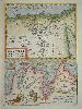
Imprint: Antwerp, 1570-[79]
Edition: First Edition 325 x 230 mm., in good modern wash colour, in good condition.
This is the right side only from a double page map sheet that contained one of Asia Minor to the left. This half features a well engraved map of Egypt drawn from one published by Paolo Forlani in Venice 1566. The lower map is of the ancient city of Carthage again drawn from an Italian source which although unidentified can be dated to 1535. It was published in the first edition of Abraham Ortelius' 'Theatrum Orbis Terrarum' in 1570, the first modern atlas. This example was issued in the Latin text edition of 1579. Van den Broecke 174b & c; refer Woodward 'The Maps and Prints of Paolo Forlani' 49.
Stock number:6996.
|
|

Imprint: Venice, 1598-[1655]
80 x 100 mm., in good condition.
This edition of the miniature Ortelius atlas entitled 'Il Theatro del Mondo' was first published in Brescia in 1598. The map is derived directly from that in the 1577 miniature Ortelius atlas, itself a reduced version of the folio by Ortelius in 1570. Shirley Atlases in the BL T.Bot 1a.
Stock number:5788.
|
|

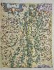
Imprint: Antwerp, 1579-[80]
360 x 510 mm., early wash colour, in very good condition.
This is Abraham Ortelius' fine map of the region of Cremona from the 'Theatrum Orbis Terrarum'. It was first published in 1579, this example with German text to the verso is from an edition issued the following year. Cartographically it is derived from a manuscript map of the area by Antonio Campi which was not finally published until 1583. The map extends from Mantua in the east to Cremona, Piacenza and Crema in the west. The inset map of Crema is after a printed map by Paolo Forlani issued in 1570. Van den Broecke no. 127.
Stock number:7030.
|
|

Imprint: Antwerp, 1570-[87]
345 x 500 mm., in fine modern wash colour, a small wormhole by the cartouche lower right repaired, otherwise in good condition.
This is one of the most recognisable of all the early maps of the British Isles. It was published by Abraham Ortelius in his 'Theatrum Orbis Terrarum' first published in 1570, the first modern atlas. This example was issued in the French text edition of 1587 with the pagination 9 to the verso. The map is derived from Gerard Mercator's eight sheet wall map of 1564. It is a beautifully designed plate with a nice balance between accurate cartographic information and ornate decoration. The map is orientated with north to the right and the Royal Coat of Arms are depicted upper left. Shirley speculates that the engraver was Frans Hogenberg. Van Den Broecke 16; Shirley British Isles no. 86.
Stock number:6982.
|
|

Imprint: Antwerp, 1573-[95]
Edition: First Edition 380 x 470 mm., an excellent dark impression in very good condition.
This classic ornate map of England and Wales was first published in the 1573 edition of Abraham Ortelius' 'Theatrum Orbis Terrarum', the first modern atlas. This map improved on the earlier Ortelius map of the British Isles published in 1570. This is particularly noticeable in the depiction of South Wales, Devon, the Wash and Humber River. The source for much of this new information is the Welsh historian and topographer Humphrey Lhuyd. He died in 1568 so the manuscript must have been finished by that date. It is possible it did not reach the hands of Ortelius until sometime after his death, most likely post 1570. This example is from a Latin text edition with pagination that matches the 1595, 1601 and 1603 editions. This is an example of the third state, stippled sea, and as this is such a sharp fresh example we have made the assumption that it is from the 1595 edition, the first edition in which this state appeared. Van der Broecke, M. 19.2; North, F. J. 'Humphrey Lhuyd's Maps of England and of Wales', Cardiff 1937; Shirley, R.W. (BI to 1650) 98.
Stock number:7307.
|
|

Imprint: London, 1605-[09]
435 x 570 mm., in full early wash colour, trimmed close to the side margins as is often the case, with no apparent loss, otherwise in very good condition.
The second state with Latin text of Jan Baptiste Vrients classic map of England, Wales and Scotland issued to celebrate the recent accession of James I to the throne. It first appeared in the English text edition of Abraham Ortelius' Theatre of the World published in 1606. On the death of Queen Elizabeth I in March 1603, James VI of Scotland inherited the throne. Along with uniting the Scottish and English thrones he claimed historical rights to the throne of France. The dedication of the English edition of the atlas is to James by the grace of God, King of Great Britaine, France and Ireland and was clearly made to cultivate sales. A similar claim appears on this map upper right on the first state.In 1608 Vrients published an Italian edition dedicated to the Pope. The Catholic Church did not recognize James I, a protestant, as King of France then ruled by Henry IV. This was also the case for Ireland. Therefore Vrients issued variants of the map in which a pasted label re-written would be placed over the offending part of the map; this did however still leave one further reference to the claim still visible in almost all known examples. These are known as variants of the first state. For the Latin edition of 1609 offered here Vrients was clearly prepared having had time to alter the plates themselves. All references to James I being King of France and Ireland are removed creating the second state. Below these references in the upper right is an attractive family tree of the English royal family from William the Conqueror. The map itself is derived from the Anonymous map printed in London 1594 which itself is derived from that of Jodocus Hondius of 1592. The engravers are believed to the Arsenius brothers who have produced a magnificent map, one of the finest ever produced for the atlas. Its desirability along with the fact that it only appears in a handful of editions makes this one of the rarest. Shirley (1991) no. 275, see also 164 & 177; Kelly (2007); Van den Broecke, M. no. 17.
Stock number:7752.
|
|

Imprint: Antwerp, 1570-[c.79]
345 x 500 mm., in fine recent wash colour, in good condition.
This is one of the most recognisable of all the early maps of the British Isles. It was published by Abraham Ortelius in his 'Theatrum Orbis Terrarum' first published in 1570, the first modern atlas. This example was issued following some touching up to the engraving which occurred in 1579 and is therefore in its second state. The map is derived from Gerard Mercator's eight sheet wall map of 1564. It is a beautifully designed plate with a nice balance between accurate cartographic information and ornate decoration. The map is orientated with north to the right and the Royal Coat of Arms are depicted upper left. Shirley speculates that the engraver was Frans Hogenberg. Van Den Broecke 16; Shirley British Isles no. 86.
Stock number:7710.
|
|

Imprint: Antwerp, 1605-[09]
435 x 570 mm., in full wash colour, trimmed close to the side margins as is often the case, with small neat line loss on the right, old fold lower right, old lower centrefold restoration in the margin, margin support to verso of upper margin, otherwise in good condition.
The second state with Latin text of Jan Baptiste Vrientsâ classic map of England, Wales and Ireland issued to celebrate the recent accession of James I to the throne. It first appeared in the English text edition of Abraham Ortelius' âTheatre of the Worldâ published in 1606. On the death of Queen Elizabeth I in March 1603, James VI of Scotland inherited the throne. Along with uniting the Scottish and English thrones he claimed historical rights to the throne of France. The dedication of the English edition of the atlas is to 'James by the grace of God, King of Great Britaine, France and Ireland' and was clearly made to cultivate sales. A similar claim appears on this map upper right on the first state.In 1608 Vrients published an Italian edition dedicated to the Pope. The Catholic Church did not recognise James I, a Protestant, as King of France then ruled by Henry IV. This was also the case for Ireland. Therefore, Vrients issued variants of the map in which a pasted label re-written would be placed over the offending part of the map; this did however still leave one further reference to the claim still visible in almost all known examples. These are known as variants of the first state. For the Latin edition of 1609 offered here Vrients was clearly prepared having had time to alter the plates themselves. All references to James I being King of France and Ireland are removed creating the second state. Below these references in the upper right is an attractive family tree of the English royal family from William the Conqueror. The map itself is derived from the Anonymous map printed in London 1594 which itself is derived from that of Jodocus Hondius of 1592. The engravers are believed to the Arsenius brothers who have produced a magnificent map, one of the finest ever produced for the atlas. Its desirability along with the fact that it only appears in a handful of editions makes this one of the rarest. Van den Broecke (1996) M. no. 17; Shirley (1991) no. 275, see also 164 & 177; Kelly (2007).
Stock number:9133.
|
|

Imprint: Antwerp, 1590-[98]
330 x 425 mm., recent wash colour. Good condition.
The map is derived from that of Natale Bonifacio (1538-92) which was published in Rome in 1587. Three years later Abraham Ortelius used the map for his 'Theatrum'. This example with French text to the verso comes from the 1598 edition. Van den Broecke no. 138; Meurer p. 118.
Stock number:4709.
|
|
|
Imprint: Antwerp, 1590-[98]
330 x 425 mm., recent wash colour, in good condition.
The map is derived from that of Natale Bonifacio (1538-92) which was published in Rome in 1587. Three years later Abraham Ortelius used the map for his 'Theatrum'. This example with Spanish text to the verso comes from the 1612 edition. Van den Broecke no. 138; Meurer p. 118.
Stock number:10379.
|
|
Imprint: Antwerp, c.1584
305 x 245 mm. in fine early wash colour, narrow margins to left where detached from accompanying plate, otherwise in good condition.
According to Meurer the source for this map is Daniel Speckel's three-sheet map of Elsas. Speckel (1536-89) is identified on the map as the source. He was a native of Strasbourg and an engraver by profession. He was also a fortress engineer and architect. He travelled extensively building various fortresses in Hungary, Vienna and The Netherlands. Abraham Ortelius here employs him to produce a map of the region around Strasbourg for the 'Theatrum Orbis Terrarum' which was first issued in 1584. Van den Broecke, M. 112b; Karrow 1/132; Meurer pp. 243-4; Norton 'Daniel Speklin: map-maker and architect', in 'Mapline' 21 pp. 1-2.
Stock number:5174.
|
|

Imprint: Antwerp, 1584-[1608]
305 x 205 mm., in fine modern wash colour, narrow margins to left where detached from accompanying plate, otherwise in good condition.
According to Meurer the source for this map is Daniel Speckel's three-sheet map of Elsas. Speckel (1536-89) is identified on the map as the source. He was a native of Strasbourg and an engraver by profession. He was also a fortress engineer and architect. He travelled extensively building various fortresses in Hungary, Vienna and The Netherlands. Abraham Ortelius here employs him to produce a map of the region around Strasbourg for the 'Theatrum Orbis Terrarum' which was first issued in 1584. Van den Broecke, M. 112b; Karrow 1/132; Meurer pp. 243-4; Norton 'Daniel Speklin: map-maker and architect', in 'Mapline' 21 pp. 1-2.
Stock number:5593.
|
|

Imprint: Antwerp, 1587-[88]
375 x 485 mm., in recent wash colour, small lower margin split professionally repaired just outside the image, otherwise in good condition.
An attractive uncommon map depicting the region of Artesia in France. This map was first published in the French edition of 1587 of Abraham Ortelius' 'Theatrum Orbis Terrarum', the first modern atlas of the world. It is derived from a manuscript map of Jacques Surhon made in 1554. Van der Broecke notes that he was paid 36 Livres for his work. It was however not printed due to the conflicts in the border region at the time. It was only later when Antwerp had been independent of the Catholic influences for a short time that Ortelius published it. This example bears Spanish text to the verso and appeared in the 1588 edition. Indeed the map only appears in four editions of the atlas, it was replaced by a new plate in 1595. Van den Broecke, M. 73; Meurer pp. 250-1.
Stock number:8326.
|
|