|
|
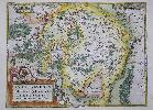
Imprint: Antwerp, 1579-[80]
370 x 500 mm., in fine wash colour, good condition.
This is the only map of Luxembourg in the famous Abraham Ortelius "Theatrum Orbis Terrarum". It first appeared in the 1579 edition and this example comes from the German edition published the following year. The map was originally drawn by Jacques Surhon for which he received 500 Livres in payment from Charles V in 1551. It was however never published. Van den Broecke, M. 60.1; Van der Vekene 102A.
Stock number:8328.
|
|

Imprint: Antwerp, 1573-[1602]
370 x 420 mm., early wash colour, in good condition.
The map centres on Mansfeld in Saxony, to the west is the city of Halle. It is derived from the work of Stella in 1561 and was published in Abraham Ortelius' 'Theatrum Orbis Terrarum', the first modern atlas, from 1573. This example with Spanish text to the verso was published in 1602 and is in the second state of three. Karrow 72/7.2 & 55/2; Van der Broecke 39.
Stock number:5581.
|
|

Imprint: Antwerp, 1573-[88]
Edition: First Edition 360 x 470 mm., modern wash colour, in very good condition.
An attractive map of Moravia covering the region of present day eastern Czech Republic centred on the town of Brin. Originally drawn by Paul Fabritius in 1569 the map was reworked by Johann Krafft in 1570. First edition with Spanish text paginated 55 on the verso. Van den Broecke, M. 104.
Stock number:4725.
|
|

Imprint: Antwerp, 1570-[79]
Edition: First Edition 325 x 230 mm., in good modern wash colour, in good condition.
This is the left side only from a double page map sheet that contained two smaller maps at the right. This half features a well engraved map of Turkey which is oriented with the north to the left. The map is derived from the extremely rare map of Giacomo Gastaldi as published by Paolo Forlani in Venice 1564. It depicts the whole of Asia Minor or present day Turkey in excellent detail and includes the important islands of Cyprus, Rhodes and Crete. It was published in the first edition of Abraham Ortelius' 'Theatrum Orbis Terrarum' in 1570, the first modern atlas. This example was issued in the Latin text edition of 1579 with the pagination 88 to the verso. Van den Broecke 174a; refer Woodward 'The Maps and Prints of Paolo Forlani' 26.01; Zacharakis, C. 1613.
Stock number:6997.
|
|

Imprint: Antwerp, 1570-[80]
Edition: First Edition 325 x 230 mm., in fine modern wash colour, in good condition.
This is the left side only from a double page map sheet that contained two smaller maps at the right. This half features a well engraved map of Turkey which is oriented with the north to the left. The map is derived from the extremely rare map of Giacomo Gastaldi as published by Paolo Forlani in Venice 1564. It depicts the whole of Asia Minor or present day Turkey in excellent detail and includes the important islands of Cyprus, Rhodes and Crete. It was published in the first edition of Abraham Ortelius' 'Theatrum Orbis Terrarum' in 1570, the first modern atlas. This example was issued in the German text edition of 1580 with the pagination 88 to the verso. Van den Broecke 174a; refer Woodward 'The Maps and Prints of Paolo Forlani' 26.01; Zacharakis, C. 1613.
Stock number:8306.
|
|
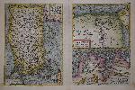
Imprint: Antwerp, 1570-[74]
Edition: First Edition 325 x 495 mm., in fine modern wash colour, in good condition.
This map was published in the first edition of Abraham Ortelius' 'Theatrum Orbis Terrarum' in 1570, the first modern atlas of the world. This example was issued in the Latin text edition of 1574 with the pagination 67 to the verso. The left side of the map sheet features a well engraved map of Turkey which is oriented with the north to the left. It is derived from the extremely rare map of Giacomo Gastaldi as published by Paolo Forlani in Venice 1564. It depicts the whole of Asia Minor or present day Turkey in excellent detail and includes the important islands of Cyprus, Rhodes and Crete. The two smaller maps at the right feature the Lower Nile region of Egypt and the region of ancient Carthage. Van den Broecke 174; refer Woodward 'The Maps and Prints of Paolo Forlani' 26.01; Zacharakis, C. 1613.
Stock number:8320.
|
|

Imprint: Antwerp, 1584-[1608]
305 x 240 mm., full recent wash colour, in good condition.
The second of two single page maps of Bavaria, Germany published by Abraham Ortelius in the 'Theatrum Orbis Terrarum'. This one is distinguished by the title being at the bottom of the map. It is derived from the map by Erhart Reich published in woodcut in 4 sheets in 1540. Regensberg is easily identified near the centre with 'Nurnberg' to the left of the map. Van den Broecke 112a; Karrow 63.
Stock number:8203.
|
|
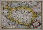
Imprint: Antwerp, 1584-[98]
305 x 490 mm., recent full wash colour, in good condition.
The second of two single page maps of Bavaria, Germany published by Abraham Ortelius in the 'Theatrum Orbis Terrarum'. This one is distinguished by the title being at the bottom of the map. It is derived from the map by Erhart Reich published in woodcut in 4 sheets in 1540. Regensberg is easily identified near the centre with 'Nurnberg' to the left of the map. Paired with it is a map of the region surrounding Strasbourg. It is derived from Daniel Specklin's three-sheet map of the Alsace issued in 1576. This French text issue was published in 1598. Van den Broecke 112; Karrow 63.
Stock number:8614.
|
|

Imprint: Amsterdam, 1601-[09]
80 x 120 mm., with Latin text to the verso, good condition.
Van der Krogt, P. (Atlantes) 8200:333. This little map comes from the Coignet edition of Abraham Ortelius' 'Epitome' first published in 1601. It is engraved by the Arsenius brothers. With Latin text to the verso. Koeman Ort 65; Phillips 3407; Van der Krogt, P. (Atlantes) 8200:333.
Stock number:4951.
|
|

Imprint: Amsterdam, 1595
80 x 110 mm., in good condition.
This map is from the rarer first series of plates to Abraham Ortelius' miniature edition of his folio .Theatrum Orbis Terrarum'. It was first published in 1577. This is a map of Persia or present day Iran.
Stock number:4953.
|
|
Imprint: Antwerp, 1570-[80]
Edition: First Edition 360 x 500 mm., with modern wash colour in good condition.
This map was published in the first edition of Abraham Ortelius' Theatrum Orbis Terrarum' in 1570, the first modern atlas. This example was issued in the German text edition of 1580 with the pagination 85 on the verso. It is derived from Giacomo Gastaldi's fabulous map entitled 'Asia Minor' published in 1564 and Ortelius' own wall map of Asia, 1567. Al Qasimi p. 19; Karrow p. 246; Meurer p. 151; Van den Broecke, M. 167.
Stock number:8319.
|
|

Imprint: Antwerp, 1579-[88]
360 x 510 mm., in fine recent wash colour, slight loss to lower corners, repaired, otherwise in good condition.
This map of the Poitou region of western France is derived from the lost original by Pierre Rogier published in Paris by Francois Desprez. Meurer p. 224; Van den Broecke, M. 38.1.
Stock number:5619.
|
|

Imprint: Antwerp, 1587-[92]
34 x 51 cms., in fine modern wash colour. In excellent condition.
The map is derived from a two-sheet map by Fernando Alvarez Secco which was published by Michele Tramezzino in 1561. This is an early issue of the second of two plates by Ortelius of Portugal. There are only subtle differences in engraving between them. Van den Broecke, M. #27, state 1; 'Cartografia Impressa dos Seculos XVI e XVII Imagens de Portugal ...' Exhibition Catalogue no. 22; Koeman Ort no. 8 (not realising the two plates existed); 'Olhar o Mundo ler o Territorio' Exhibition Catalogue p. 144.
Stock number:4183.
|
|

Imprint: Antwerp, 1570-[1602]
310 x 480 mm., early wash colour, in good condition.
The majority of the map displays the region of central France to the west of Nevers centred on the town of Bourges. An inset to the right details the region immediately to the north of Lyon. It is derived from the work of Gabriel Symeoni (1509-70) in 1561 and was published in Abraham Ortelius' 'Theatrum Orbis Terrarum', the first modern atlas, from 1573. This example with Spanish text to the verso was published in 1602. Karrow p. 114-15; Van der Broecke 39.
Stock number:5580.
|
|

Imprint: Antwerp, 1573-[98]
345 x 260 mm., fine modern wash colour, in good condition.
A beautifully engraved map of Rhaetiae and the Tirol published by Abraham Ortelius in his 'Theatrum Orbis Terrarum', the first uniform world atlas to be published. This map first appeared in the edition of 1573, this example with French text to the verso appeared in the 1598 edition. The cartography is derived from Wolfgang Lazius in 1561. Karrow 49/21; Van der Broecke 116.
Stock number:8305.
|
|

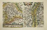
Imprint: Amsterdam, 1573-[88]
340 x 500 mm., in recent full wash colour, early manuscript in left margin, finger marks in lower corners, otherwise in good condition.
The left side of this map bears a beautifully engraved map of Rhaetiae and the Tirol. The right side one of the Istrian peninsula. It is published by Abraham Ortelius in his 'Theatrum Orbis Terrarum', the first uniform world atlas to be published. This map first appeared in the edition of 1573, this example with Spanish text to the verso appeared in the 1588 edition. The cartography is derived from Wolfgang Lazius in 1561. Karrow 49/21; Van der Broecke 116.
Stock number:8630.
|
|

Imprint: Antwerp, 1584-[88]
305 x 200 mm., in recent wash colour, otherwise in good condition.
An attractive decorated map depicting the region of Rugen and the nearby mainland in Germany and modern day Poland including the modern city of Szczecin. This map was first published in Abraham Ortelius' 'Theatrum Orbis Terrarum' in 1584, the first modern atlas of the world. This example with plain back was issued in 1588. It is derived from a manuscript map sent by Petrus von Edeling (1521-1602) to Ortelius on the island of Rugen. Van den Broecke, M. 89b; Meurer pp. 132-3.
Stock number:9345.
|
|

Imprint: Antwerp, 1570-[87]
340 x 440 mm., in fine early wash colour.
This is the earlier prefered plate of Salzburg in Abraham Ortelius' 'Theatrum Orbis Terrarum'. It includes a fine birds-eye view of the town. Van den Broecke, M. #107; Karrow 68/1 pp. 475-7.
Stock number:4085.
|
|

Imprint: Antwerp, 1570-[89]
Edition: First Edition 350 x 510 mm., in recent wash colour, otherwise in good condition.
An attractive bordered map depicting the region of Saxony, Germany, with the city of Leipzig near the centre. This map was published in the first edition of Abraham Ortelius' 'Theatrum Orbis Terrarum' in 1570, the first modern atlas of the world. This example with German text on the verso is from the 1589 edition. It is derived from a map by Johann Criginger (1521-71). Van den Broecke, M. 93; Karrow 22/1; Meurer pp. 132-3.
Stock number:8327.
|
|

Imprint: Antwerp, 1570-[88]
Edition: First Edition 350 x 510 mm., in recent wash colour, otherwise in good condition.
An attractive bordered map depicting the region of Saxony, Germany, with the city of Leipzig near the centre. This map was published in the first edition of Abraham Ortelius' 'Theatrum Orbis Terrarum' in 1570, the first modern atlas of the world. This example with Spanish text on the verso is from the 1588 edition. It is derived from a map by Johann Criginger (1521-71). Van den Broecke, M. 93; Karrow 22/1; Meurer pp. 132-3.
Stock number:9342.
|
|