|
|
|
Imprint: Antwerp, 1570-[98]
Edition: First Edition 350 x 510 mm., in recent wash colour, otherwise in good condition.
An attractive bordered map depicting the region of Saxony, Germany, with the city of Leipzig near the centre. This map was published in the first edition of Abraham Ortelius' 'Theatrum Orbis Terrarum' in 1570, the first modern atlas of the world. This example with French text on the verso is from the 1598 edition. It is derived from a map by Johann Criginger (1521-71). Van den Broecke, M. 93; Karrow 22/1; Meurer pp. 132-3.
Stock number:10375.
|
|

Imprint: Antwerp, 1573-[88]
330 x 490 mm., in early wash colour. Small dark ink mark in sides.
One half of a map depicting the region of Siena in Italy. This map was first published in the Latin edition of Abraham Ortelius' 'Theatrum Orbis Terrarum' in 1573, the first modern atlas of the world. It is derived from the map of Cesare Orlandi in 1573, which in itself if probably drawn from Claudio Duchetti's undated earlier map. This example bears Spanish text to the verso and appeared in the 1588 edition. Van den Broecke, M. 137; Meurer pp. 210-11.
Stock number:8325.
|
|

Imprint: London, 1573-[1602]
330 x 490 mm., with recent wash colour, in good condition.
One half of this map depicts the region of Siena in Italy. The other half is split between a map of Corsica and one of Ancona. This map was first published in the Latin edition of Abraham Ortelius' 'Theatrum Orbis Terrarum' in 1573, the first modern atlas of the world. That of Siena is derived from the map of Cesare Orlandi in 1573, which in itself if probably drawn from Claudio Duchetti's undated earlier map. This example bears Spanish text to the verso and appeared in the 1602 edition. Van den Broecke, M. 137; Meurer pp. 210-11.
Stock number:8612.
|
|

Imprint: Antwerp, 1570-[88]
280 x 390 mm., modern wash colour, in good condition.
This map of Silesia is derived from that of Martin Helwig (1516-74) published in 1561 as stated in the title. It survives in just the one known example at the Badische Landesbibliothek, Karlsruhe, Germany. Helwig was a native of Silesia being born in Neisse, his diary survives in the University Library of Wroclaw. It is present day south western Poland and displays both Crakaw(Krakow) in the east and Breslaw (Wroclaw) in the centre. This Abraham Ortelius version was first published in the initial edition of the 'Theatrum Orbis Terrarum' in 1570. This example was issued in the Spanish text edition of 1588 with the pagination 54 to the verso. Karrow p. 38.1; Meurer p. 163; Van den Broecke, M. #102.
Stock number:4706.
|
|
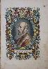
Imprint: 1579
325 x 220 mm., later wash colour, with some marginal light waterstain and minor crease, neither affecting the image, otherwise in good condition.
This is one of the most famous portraits of a cartographer. Engraved by Philip Galle, it is of Abraham Ortelius (1527-98) at the age of about 50. It was first published in his atlas the 'Theatrum Orbis Terrarum' in 1579. A fine ornate portrait likely taken from the painting by Paul Rubens currently displayed in the Plantin-Moretus Museum. Hind I p. 157. pl. 91; Van den Broecke (1996) pp. 14-15.
Stock number:8818.
|
|

Imprint: Antwerp, 1575-[80]
310 x 430 mm., in fine early wash colour, in very good condition.
This map of Transilvania is derived from that of Sambucus 1566 itself drawn from Honter in 1532. This example with Latin text to the verso is from the first 1580 edition. Within five years of first publication Ortelius had to replace the plate with this one. This is a fine example of the first state of four. The map extends to cover parts of Poland, Slovakia, Romania & Hungary. Karrow 65/1 pp. 459-60; Meurer p. 226; Van den Broecke, M. #153.1.
Stock number:7028.
|
|
|
Imprint: Antwerp, 1573-[1602]
295 x 210 mm., early wash colour, in good condition.
The map is orientated with north to the left. Upper centre is the town of Naumberg to the east but the map is centred on the city of 'Erfurdt'. According to Van der Broecke 'Magdeburg complained to Ortelius (Hessels 1887, 110) that Mellinger had plagiarised his map of Thuringen and that Scultetus had done the same for his Meissen map. Meurer considers this complaint unfounded. Ortelius never acted on it'. It was published in Abraham Ortelius' 'Theatrum Orbis Terrarum', the first modern atlas, from 1573. This example bears Spanish text on the verso and is from the edition of 1602. Karrow 1/83 & 55/1.1; Van der Broecke 96a.
Stock number:8623.
|
|

Imprint: Antwerp, 1584
345 x 495 mm., early wash colour. Some very minor foxing, margins have been trimmed slightly but are good. A fine example of a rare map.
In 1584 Abraham Ortelius introduced a new map to his ‘Theatrum Orbis Terrarum’. It was his first of the Spanish region of Valencia in recognition of its importance in Mediterranean trade. Van den Broecke states that at the time he published his work in 1996, only three examples from this plate were known! However, since he drew attention to it a few more have surfaced. He now concludes that it was in print for the editions through that in Latin in 1592. This is an example of its very first issue in the 1584 Latin edition without pagination on the verso. It was replaced by an entirely new plate for the 1595 edition with flourishing lettering for the Mediterranean Sea. The map is engraved in the typical style of Ortelius with ornate strapwork cartouches and stipple engraved sea. Numerous villages and towns are identified with an extensive network of rivers. The whole is embellished with a sailing ship and a galley. The map is oriented with north to the right. Van den Broecke (1996) no. 29; not in Karrow, Koeman or Meurer.
Stock number:5380.
|
|

Imprint: Antwerp, c.1580
315 x 225 mm., in recent wash colour, good condition.
This map was first published in the Latin edition of Abraham Ortelius' 'Theatrum Orbis Terrarum' in 1579, the first modern atlas of the world. This is the right half of a folio sheet map which depicts the region of Waldeck, derived from Justus Meurs' six-sheet map of the region published in 1572. Van den Broecke 98b; Meurer p. 202.
Stock number:8324.
|
|

Imprint: Antwerp, 1579-[80]
Edition: First Edition 350 x 505 mm., in recent wash colour, otherwise in good condition.
FIRST GERMAN EDITION. An attractive bordered map depicting the region of Westphalia, Germany, extending from Cologne in the right to Bremen and Emden in the left or north. This map was first published in Abraham Ortelius' 'Theatrum Orbis Terrarum' in 1579, the first modern atlas of the world. This example with German text is from the first edition in that language published in 1580. It is derived from a manuscript map by Christian Sgroten from 1565. Van den Broecke, M. 91; Meurer pp. 132-3.
Stock number:9344.
|
|
|
Imprint: London, Printed for T. Osborne. J. Robinson. D. Browne. W. Johnston. J. Hodges. P. Davey & A. Millar. B. Law, 1748-[c.56]
Binding: Hardback Inscription: Signed, Inscribed Or Annotated Quarto (175 x 105 mm.), nineteenth century half calf, marbled paper boards, blind ruled, spine with raised bands, red calf gilt title and date labels. With engraved title page, pp. 39, (27), (2), with 61 double page maps numbered to 60, the folding general map at the beginning being unnumbered. There are two maps numbered 19 and two 56. There are no maps numbered 22 or 50, each map identified in contemporary hand on verso, light waterstain to index leaves, one or two maps trimmed close, otherwise in good condition.
In the �London Evening Post� for 21-23 July 1747 was an advert stating that 'Now Engraving, In a beautiful Manner, and of proper Size to carry in the Pocket, or to bind with the Tour � A Complete Set of Maps of all the Counties in England, Scotland, and Wales � on a larger Scale than any Pocket Map hitherto publish�d'. The �Tour� referred to the well known book by Daniel Defoe of the period, it was partly owned by the same publishers. There appears to have been a minor delay in the first issue as it was not advertised as being complete until the �General Evening Post� of 8-10 November 1748. Despite naming Scotland the two were made available separately and we may normally find England and Wales together, as in this example which was originally priced at 6s. Numerous adverts were placed in the ensuing months and no doubt this was due to the competition of Thomas Badeslade & William Toms� �Chorographia Britanniae� and the Thomas Kitchin and Thomas Jeffery�s �Small English Atlas�.This second and final edition of the 'Geographia Magnae Britanniae' was issued utilising the original letterpress material. The date of 1748 remains on the title page which has otherwise been retouched and had its imprint altered to reflect the new partners. John Osborne had left the trade by November 1751 and Samuel Birt had died in November 1755. The transfer of their shareholding is not recorded but the revised title records the new shareholders are William Johnston and P. Davey and Bedwell Law. No advert has been located for this edition, it is presumed that it was issued shortly after and the date of circa 1756 is generally accepted. Evidence for this date also comes from the fact that the companion atlas of Scotland was issued dated 1756. The maps are unaltered including the errors of numeration and in this example the letterpress follows them. The leaf containing the Tables and unaltered advert is placed at the end of the atlas. The maps of England and Wales and Gloucestershire in the atlas are signed by Thomas Hutchinson as engraver and although there are similarities in style with the remainder of the maps, Hodson does not believe he was responsible for them all. Provenance: Brian Kentish Catalogue 2008 item 45Chubb (1927) 189; ESTC N18304; Hodson (1984-97) 206.
Stock number:9905.
|
|
|
Imprint: London, Printed for S. Birt. T. Osborne. D. Browne. I. Hodges. I. Osborne. A. Millar. I. Robinson, 1748
Binding: Hardback Inscription: Signed, Inscribed Or Annotated Octavo (170 x 110 mm.), recent full calf, ornate blind panelled boards, spine with raised bands, ornate blind ruled compartments, each with central blind feature, green calf gilt title and date labels, later endpapers. With engraved title page, pp. 39, (27), (2), with 61 double page maps numbered to 60, the folding general map at the beginning being unnumbered. There are two maps numbered 19 and two 56. There are no maps numbered 22 or 50, Yorkshire trimmed close as often the case, otherwise in good condition.
In the London Evening Post for 21-23 July 1747 was an advert stating that 'Now Engraving, In a beautiful Manner, and of proper Size to carry in the Pocket, or to bind with the Tour … A Complete Set of Maps of all the Counties in England, Scotland, and Wales … on a larger Scale than any Pocket Map hitherto publish’d'. The ‘Tour’ referred to the well known book by Daniel Defoe of the period, it was partly owned by the same publishers. There appears to have been a minor delay in the first issue as it was not advertised as being complete until the General Evening Post of 8-10 November 1748. Despite naming Scotland the two were made available separately and we may normally find England and Wales together, as in this example which was originally priced at 6s. Numerous adverts were placed in the ensuing months and no doubt this was due to the competition of Thomas Badeslade & William Toms’ Chorographia Britanniae and the Thomas Kitchin and Thomas Jeffery’s Small English Atlas.Traditionally the atlas has been ascribed to Thomas Osborne. Although the names of seven publishers appear on the title page, no clear attribution is made. Often the size of the share in the work indicated their principal listing in the order of names. The first named is Samuel Birt who died in November 1755. A second edition appeared soon after in which the first named is Thomas Osborne who appeared as the second named in this edition. Therefore the work has commonly been called Osborne’s. He was also ‘the most celebrated bookseller of his day’ (Dibdin). Osborne had inherited a considerable booksellers and publishers business from his father of the same name in Gray’s Inn. It appears though that this brought with it an unfortunate air. Marston wrote that ‘to his inferiors he generally spoke with an authoritative and insolent manner’.The maps of England and Wales and Gloucestershire in the atlas are signed by Thomas Hutchinson (fl.1733-54) as engraver and although there are similarities in style with the remainder of the maps, Hodson does not believe he was responsible for them all. Chubb (1927) 190; ESTC T151875; Hodson (1984-97) 205; Shirley (2004) T.Hut 1a; Worms & Baynton-Williams (2011).
Stock number:10162.
|
|
|
Imprint: London, Printed for S. Birt. T. Osborne. D. Browne. I. Hodges. I. Osborne. A. Millar. I. Robinson, 1748
Binding: Hardback Inscription: Signed, Inscribed Or Annotated Octavo (170 x 110 mm.), contemporary quarter calf, marbled paper boards, spine with raised bands, worn. With engraved title page, pp. 39, (27), (2), with 61 double page maps numbered to 60, the folding general map at the beginning being unnumbered. There are two maps numbered 19 and two 56. There are no maps numbered 22 or 50, light water stain to index leaves, otherwise in good condition.
In the 'London Evening Post' for 21-23 July 1747 was an advert stating that 'Now Engraving, In a beautiful Manner, and of proper Size to carry in the Pocket, or to bind with the Tour … A Complete Set of Maps of all the Counties in England, Scotland, and Wales … on a larger Scale than any Pocket Map hitherto publish’d'. The ‘Tour’ referred to the well known book by Daniel Defoe of the period, it was partly owned by the same publishers. There appears to have been a minor delay in the first issue as it was not advertised as being complete until the 'General Evening Post' of 8-10 November 1748. Despite naming Scotland, the two were made available separately and we may normally find England and Wales together, as in this example which was originally priced at 6s. Numerous adverts were placed in the ensuing months and no doubt this was due to the competition of Thomas Badeslade & William Toms’ 'Chorographia Britanniae' and the Thomas Kitchin and Thomas Jeffery’s 'Small English Atlas'.Traditionally the atlas has been ascribed to Thomas Osborne. Although the names of seven publishers appear on the title page, no clear attribution is made. Often the size of the share in the work indicated their principal listing in the order of names. The first named is Samuel Birt who died in November 1755. A second edition appeared soon after in which the first named is Thomas Osborne who appeared as the second named in this edition. Therefore, the work has commonly been called Osborne’s. He was also ‘the most celebrated bookseller of his day’ (Dibdin). Osborne had inherited a considerable bookseller and publishing business from his father of the same name in Gray’s Inn. It appears though that this brought with it an unfortunate air. Marston wrote that ‘to his inferiors he generally spoke with an authoritative and insolent manner’. The maps of England and Wales and Gloucestershire in the atlas are signed by Thomas Hutchinson (fl.1733-54) as engraver and although there are similarities in style with the remainder of the maps, Hodson does not believe he was responsible for them all. Chubb (1927) 190; ESTC T151875; Hodson (1984-97) 205; Shirley (2004) T.Hut 1a; Worms & Baynton-Williams (2011).
Stock number:10161.
|
|

Imprint: London, 1714
350 x 495 mm., a good example with wide margins.
It is conceivable that this one final plate was already in production by Sutton Nicholls when Henry Overton acquired the John Speed plates from Christopher Browne around 1713. Dated 1714 it stands out from the balance which can be dated to 1711 and 1712. The exact reason for the delay remains speculation. A superb plan of the town of Nottingham is inserted upper left with a description of the county including a note of the roads below. Although the map is derived from the Robert Morden of 1695 the plan of Nottingham is from an unknown source. Hodson states that it is not drawn from that of Thoroton, 1677. He goes on to speculate that if it was indeed a new survey it may provide the reason for the delay.John Overton (1640-1713) was the son of a bookseller Henry Overton and married the daughter of the publisher William Garrett. He was a printseller who in 1665 acquired the stock of Peter Stent who died of the plague that year and who had arguably the largest collection of prints on the market at the time. Amongst this stock he found twelve copper plates of the English counties by William Smith. These formed the nucleus of a set of maps of the English Counties. Overton commissioned the engraving of some new plates for missing counties; amongst them is one of Berkshire by the great engraver Wenceslaus Hollar. Those counties which Overton could not provide from his own stock were supplied by the acquired maps of Speed, Blaeu or Jansson. These county atlases were an English version of a rich seam of similar Dutch composite atlases published from the mid-seventeenth century. They are exceedingly rare surviving in just four known examples. Later atlases sold by his son Henry are similarly rare, only seven survive. Until about 1711 both John and Henry Overton had been content to acquire the plates of Jansson and others to fill in the missing counties in their supply. Most of those of Blaeu had been lost in the disastrous fire of 1672. Quite probably around 1711 the plates of Jansson were acquired by David Mortier who possibly stopped supplying the Overton firm. This forced Henry to engrave maps of those missing counties. He employed the services of Sutton Nicholls who promptly produced five maps between 1711 and 1712. Production was halted when in about 1713 fortune gave Henry the opportunity to acquire the old John Speed plates from Christopher Browne.
Stock number:4996.
|
|

Imprint: London, c.1680-[c.1715]
370 x 470 mm., early outline colour, slight oxidisation of the orange colour, with no apparent centrefold, otherwise in very good condition.
A very rare map of the county of Oxfordshire in its second and only surviving state. The map was undoubtedly engraved for John Overton as it matches in style that of Devon, which does survive. John Overton (1640-1713) was the son of a bookseller Henry Overton and married the daughter of the publisher William Garrett. He was a printseller who in 1665 acquired the stock of Peter Stent who had died of the plague that year and who had arguably the largest collection of prints on the market at the time. Amongst this stock he found twelve copper plates of the English counties by William Smith. These formed the nucleus of a set of maps of the English Counties. Overton commissioned the engraving of some new plates for missing counties. Those which Overton could not provide from his own stock were supplied by the acquired maps of Speed, Blaeu or Jansson. These county atlases were an English version of a rich seam of similar Dutch composite atlases published from the mid-seventeenth century. They are exceedingly rare surviving in just five known examples. Of these to represent Oxfordshire one includes the Speed, one is missing and the last three all contain Jansson plates! There is no known example of the first state of this plate. Its source is the Jansson map of 1646. Later atlases sold by his son Henry are similarly rare, only seven survive. In 1713 fortune gave Henry the opportunity to acquire the old John Speed plates from Christopher Browne. Therefore the second state is also a rarity. Hodson (1984-97) p.63.
Stock number:6208.
|
|

Imprint: London, 1726
590 x 925 mm., early outline colour, with secondary folds as issued to facilitate binding, some to lower right fold repair work and at the double folds, light brown to right fold otherwise in good condition.
In 1715 Philip Overton published a rare two-sheet map of Oxfordshire. No other county followed until 1726 when in partnership with Thomas Bowles he published a reduction of the John Warburton, Joseph Bland and Payler Smyth survey of Middlesex and the neighbouring home counties of Essex and Hertfordshire undertaken 1721 to 1724. This had been published in the previous year 1725. It supplied a burgeoning market for more accurate maps than those of Christopher Saxton, John Norden, William Smith or John Speed which were now over a century old. Although the plate was extant until at least 1795 when it appeared in the catalogue of Bowles and Carver the fact that it was separately published accounts for the poor survival. It is mainly those examples preserved in composite atlases over the years which have survived. Despite covering three counties its size enables a good level of detail at half an inch to the mile. Upper left the map is adorned with a town plan of St. Alban’s and upper right is a fine ‘North Prospect of Colchester’. Provenance: private English collection since the 1970s. Hodson (1974) p. 227; Hodson (1984-97) I pp. 166-8; Rodger (1972) 118; Tooley Essex in ‘The Map Collector’ no. 36 p. 36 E22.
Stock number:8175.
|
|

Imprint: London, Carington Bowles, 1764
Octavo (195 x 155 mm.), full contemporary calf, rebacked with corners repaired, spine with raised bands, gilt ruled compartments and gilt red calf title label. pp. 12, 273. Internally very clean, complete with contemporary endpapers.
Emanuel Bowen was one of the most prominent figures in English cartography during the middle of the eighteenth century. Since the highly influential 'Britannia' by John Ogilby had been first published in 1675 no smaller version had been issued. Then in the period 1718-20 a flush of four projects were conceived, three of which were completed. This was unquestionably the most successful. It is the only one of the three to include a set of county maps with the road strips. The author of the text was John Owen an antiquarian who had been admitted to the Middle Temple in 1718. Although known as the Owen and Bowen atlas it was in fact published jointly by Bowen and John Bowles. It had a long life running to numerous editions; this is an example of the 1764 standard issue according to Hodson. For this issue the old engraved title page is replaced with a new typographic one. In 1762/ 63 Carington Bowles took over the business of his uncle Thomas Bowles. Apart from issuing a new title page virtually every single road strip was updated in some way or another according to Hodson. Following the title are five newly type set preliminary leaves paginated 3 to 12. Carington Bowles advertised the new work in the 'Public Advertiser' for 8 May 1764. Hodson points out that this was the usual time of year for the Bowles family to place their advertising and may not be an accurate guide to the date of publication. Provenance: Hooten Pagnell Hall, Yorkshire. Bennett (2007) pp. 40-1; Harley, J B (1970) Introduction to "Britannia Depicta"; Hodson 164; Shirley BL T.Bow 1n.
Stock number:8832.
|
|

Imprint: London, Thomas Bowles & Emanuel Bowen, 1720
Edition: First Edition Binding: Hardback Octavo (210 x 140 mm.), contemporary full calf with ornate blind panelled boards, rebacked with raised bands, each compartment with gilt rules, blue calf gilt title and gilt date. pp. (6), 273. With 273 engraved plates of road strips and county maps printed back to back. With repairs to some gutters barely noticeable, good margins throughout apart from p. 21 trimmed close, dark impressions, otherwise in good condition.
FIRST EDITION SECOND ISSUE of Emanuel Bowen�s 'Britannia Depicta'. Bowen was one of the most prominent figures in English cartography during the middle of the eighteenth century. In 1720, he co-published with John Owen the 'Britannia Depicta or Ogilby Improv�d'. It was an instant success running to numerous editions over the next 50 years. Hodson in his detailed study of the atlas concluded that there were six different editions bearing the title page dated 1720. The first can however be broken into three further variants, only two of which Hodson identified. This is an example of the second (first recorded) issue with the variant coat of arms on p. 94 altered to reflect those of Newton in Hampshire, not Newton in Lancashire. The first two both lack the numbers to the Rapes on the map of Sussex itself, they are shown in the key only. Provenance: private English collection. Bennett (1996) pp. 40-1; Harley (1970); Hodson (1984-97) 149; Kingsley (1982) 23.1; Shirley (2004) T.Bow 1a issue not cited.
Stock number:9161.
|
|
|
Imprint: London, Thomas Bowles & Emanuel Bowen, 1720
Edition: First Edition Binding: Hardback Octavo (200 x 135 mm.), full contemporary calf with ornate blind and gilt panelled boards, rebacked with raised bands, each compartment blind ruled, burgundy calf gilt title, later endpapers. With title page, pp. (6), 273 engraved plates of road strips and county maps printed back to back, engraved throughout. Dark impressions, in good condition.
FIRST EDITION, SECOND ISSUE of Emanuel Bowen’s Britannia Depicta. Bowen (1693?-1767) was one of the most prominent figures in English cartography during the middle of the eighteenth century. In 1720, he co-published with John Owen the Britannia Depicta or Ogilby Improv’d. It was an instant success running to numerous editions over the next 50 years. Hodson, in his detailed study of the atlas concluded that there were six different editions bearing a title page dated 1720. The first can however, be broken into three further variants, only two of which Hodson identified. This is an example of the second (first recorded) issue with the variant coat of arms on p. 94, altered to reflect those of Newton in Hampshire, not Newton in Lancashire. The first two variants both lack the numbers to the Rapes on the map of Sussex itself, they are shown in the key only. Provenance: manuscript notation of 'E: Bertie' dated 1720 on front free endpaper; private English collection. Bennett (1996) pp. 40-1; Harley (1970); Hodson (1984-97) 149; Kingsley (1982) 23.1; Shirley (2004) T.Bow 1a issue not cited.
Stock number:10144.
|
|
|
Imprint: London, Thomas Bowles, 1736
Octavo (195 x 135 mm.), full contemporary calf, gilt panelled, rebacked with ribbed spine, gilt ruled compartments each with ornate gilt floral feature, with green calf title label attached, marbled endpapers. With title page, pp. 5, (3), 273, with 273 engraved plates of road strips and county maps printed back-to-back. Title page with small tear, maps of Berkshire and Radnor inserted from another example, otherwise a clean example.
Emanuel Bowen (1693?-1767)was one of the most prominent figures in English cartography during the middle of the eighteenth century. Since the highly influential 'Britannia' by John Ogilby had been first published in 1675 no smaller version had been issued. Then in the period 1718-20 a flush of four projects were conceived, three of which were completed. In 1720 Owen and Bowen’s 'Britannia Depicta or Ogilby Improv'd' was published. This was unquestionably the most successful. It is the only one of the three to include a set of county maps with the road strips. The author of the text was John Owen an antiquarian who had been admitted to the Middle Temple in 1718. Although known as the Owen and Bowen atlas it was in fact published jointly by Bowen and John Bowles (1701-79). It had a long life running to numerous editions; this is an example of the 1736 issue. This edition was also available for a while. Hodson identified 3 issues, this being an example of the first with the preliminary leaves bearing signatures A and A2 with the catchword on the first of LONDON. Provenance: manuscript inscription on verso of plate 273 dated April 16, 1799; over an earlier inscription of James Forrest; private English collection. Bennett (1996) pp. 40-1; Carroll (1996) 23; Chubb (1927) 153; Harley (1970) Introduction to 'Britannia Depicta'; Hodson (1984-97) 159; Shirley (2004) T.Bow 1i.
Stock number:10145.
|
|