|
|

Imprint: London, 1724
90 x 115 mm., in early outline colour, set within a chapter title page with engraved text below, in good condition.
Emanuel Bowen was one of the most prominent figures in English cartography during the middle of the eighteenth century. Since the highly influential Britannia by John Ogilby had been first published in 1675 no smaller version had been issued. Then in the period 1718-20 a flush of four projects were conceived, three of which were completed. In 1720 Owen and Bowens Britannia Depicta or Ogilby Improvd was published. This was unquestionably the most successful. It is the only one of the three to include a set of county maps with the road strips. The author of the text was John Owen an antiquarian who had been admitted to the Middle Temple in 1718. Although known as the Owen and Bowen atlas it was in fact published jointly by Bowen and John Bowles. It had a long life running to numerous editions. Carroll (1996) 23; Chubb (1927) 152; Hodson (1984-97) 157; Shirley (2004) T.Bow 1h; Worms & Baynton-Williams (2011).
Stock number:9307.
|
|
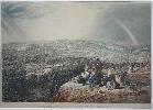
Imprint: Sheffield, Marples & Hibbert, 1844
440 x 610 mm., early hand coloured aquatint engraving, small repaired tear to sky near the rainbow, otherwise in good condition.
A very attractive large hand coloured aquatint of Sheffield engraved by J. Harris after a painting by Henry Perlee Parker (1795-1837). Printed by Brooker & Harrison it was published by Marples & Hibbert, Sheffield, April 1st 1844. Perlee was an art master at Wesley College, Sheffield and exhibited at the Royal Academy. It is a view of the burgeoning industrial city complete with smoking chimneys. The hill in the foreground bears a nice family scene including a kite about to be flown by some boys. A rainbow is placed in the right side of the image.
Stock number:7643.
|
|

Imprint: Hastings?, c.1894
410 x 610 mm. Lithographic map generally in good condition with some support to a couple of folds.
A fabulous detailed plan of the towns with all the roads named. An example of this map is found in Parsons Hastings, St. Leonards, and District Directory and Local Red Book for 1894 at the British Library. The reverse bears a small advert for Becks Compound Hop Tonic Bitters.
Stock number:3587.
|
|
|
Imprint: Peking, c.1900
295 x 635 mm., woven silk image, painted by hand, mounted and framed, in good condition.
Zhou Peichun was an artist who flourished during the Qing Dynasty (fl.1865-1910) in Peking (Beijing). His studio would come to specialise in producing albums of paintings of Chinese customs, largely for foreigners. 'Export paintings' were very popular at the time. In order to produce them in numbers he had the studio copy his originals. The image depicts a procession led by numerous attendants carrying lanterns, umbrellas, plaques and flags. They lead two palanquins accompanied by various officials. The artists name is found lower left in Chinese 'painted by Zhou Peichun in Beijing'. A search for the image has only located examples on plain beige coloured silk. We have been unable to locate one on such fine blue silk. This is likely not an original but is however due to the nature of the silk a special example. Little is known about Zhou Peichun. We do not have his date of birth or death. We do know that his shop was just outside the Shunzhimen gate. This is the west gate of the Wanping fort, a Ming Dynasty fortress, or walled city in Beijing. It was erected 1638-40. Zhou also produced a map of Beijing in 1865, examples survive at Harvard and in the MacLean Collection. References: private correspondence Richard Pegg, Maclean Collection; Victoria and Albert Museum Accession 1934 no. E.2960-1934 (watercolour on paper).
Stock number:7596.
|
|

Imprint: Gotha, 1855
210 x 175 mm., with routes lined in red as issued
This fine detailed lithographic map depicts the route to Kathmandu, the capital of present day Nepal and in the heart of the Himalayas. It was published in Gotha by J. Perthes. Petermann arrived at the Gotha in 1854 to join the published company of Perthes. He founded and produced the famous journal named after him. This is an early production. Dreyer-Eimbcke IMCoS Journal 70 pp. 19-27.
Stock number:4392.
|
|
|
Imprint: London & Liverpool, George Philip and Son, 32 Fleet Street. Liverpool: 45 yo 51 South Castle Street, c.1889
Binding: Hardback Folio (370 x 270 mm.), contemporary half calf, gilt ruled boards with ornate gilt embossed title to upper board, spine with raised bands, compartments with blind and gilt ruling, gilt titles, marbled endpapers with booksellers label of Edward Stanford inside front cover. With titlepage, Contents leaf, pp. (4), (106) and 49 wash coloured lithographic maps consisting of one general and 48 numbered counties etc., in good condition.
George Philip (1800-82) was born in Aberdeenshire and left in 1819 for Liverpool. He joined his brother who was a minister in the city. He began working with a bookseller before opening his own shop in 1834. His son George joined him in 1848. This particular series of county maps were first issued separately in the early 1860s. They were collected together for 'Philips' Atlas of the Counties of England' published in 1865. The plates for these maps were never printed in intaglio form and were used only to produce lithographic transfers. The maps themselves are derived from the one inch Ordnance Survey. Lancashire is made up of two-sheets and Yorkshire is in four.This 'New and Revised Edition' illustrates the new Parliamentary Divisions according to the Redistribution Bill of 1885. This Act redistributed the seats with the idea of equating population in each constituency. Each map had continuously been updated over time, particularly with regard to the expanding railway network. Following the maps is a 106 page index to places. Provenance: private English collection acquired 2010. Burden 119I; Carroll 123; Smith (1985) pp. 147-9.
Stock number:9811.
|
|
|
Imprint: London, George Philip and Son, 32, Fleet Street, and 51, South Castle Street, Liverpool. Edinburgh: W. P. Nimmo. Glasgow: T. Murray & Son, 1858
Edition: First Edition Binding: Hardback Octavo (160 x 105 mm.), full green cloth binding, blind embossed soft boards, central ornate gilt title, spine with blind ruling, light wear. With titlepage, Contents leaf and 28 lithographic maps consisting of one general and 27 numbered counties, in good condition.
George Philip (1800-82) was born in Aberdeenshire and left in 1819 for Liverpool. He joined his brother who was a minister in the city. He began working with a bookseller before opening his own shop in 1834. His son George joined him in 1848. This series of county maps were according to Chubb first issued as Philips Tourists Companion in 1858. The earliest edition he cites of this title is 1860. However, it appears that this atlas was issued with and without the Tourists Companion. This therefore is the first edition the atlas. There appear to be later editions of 1860, 1870 and 1882.Provenance: with ownership inscription on the title of ? Angus; private English collection acquired 2014. Chubb (1927) p. 398 no. 44; Smith (1985) pp. 147-9.
Stock number:9980.
|
|
|
Imprint: London, George Philip & Son, Ltd., London: The London Geographical Institute, 32 Fleet Street. Liverpool: Philip, Son & Nephew, 45 to 51 South Castle Street, 1885
Binding: Hardback Small folio (375 x 265 mm.), contemporary half calf, red cloth boards with gilt ruling, gilt title and vignette on upper board, spine with raised bands, gilt ruled compartments, gilt titles, marbled endpapers, light wear. With typographic title page, Contents, pp. 106, with 48 double page early wash coloured maps comprising 43 of the counties (Lancashire in 2, Leicester and Rutland combined, Yorkshire in 4), north and south Wales and 3 of islands, otherwise in good condition.
George Philip (1800-82) was born in Aberdeenshire and left in 1819 for Liverpool. He joined his brother who was a minister in the city. He began working with a bookseller before opening his own shop in 1834. His son George joined him in 1848. The maps here were first issued as loose sheets with covers but in 1865 were bound together as 'Philipsâ Atlas of the Counties of England'. They were the work of Edward Weller and derived from those in the 'Weekly Dispatch Atlas' recently published. Here he âwas more selective in the detail he showed ⦠and produced a map with perhaps greater clarityâ (Carroll). In 1885 this âNew Editionâ was published âwith a complete consulting index by John Bartholomewâ in 48 pages. Provenance: unidentified bookplate with name effaced, motto âSpernit Inertiamâ; private English collection. Carroll (1996) 123; Smith (1985) pp. 147-9; Smith (1987); Tooleyâs Dictionary (1999-2004); Worms & Baynton-Williams (2011).
Stock number:10315.
|
|

Imprint: London, Printed by William Godbid, and are to be sold at his house over against the Anchor Inne in Little Brittain, 1659
Edition: First Edition Binding: Hardback Folio (295 x 190 mm.), in full early calf corners repaired, rebacked ribbed spine with gilt ruling and ornate gilt decoration to the compartments, gilt title and date. 12 + 401, [1] pp., with large folding engraved map, and 4 text engravings. With the errors of pagination called for. The first ten leaves a little damaged at the extremities, large folding map laid on linen with one or two areas of loss due to either worming or the double folds present as issued, tipped in, otherwise in good condition.
Thomas Philipotts Villare Cantianum in its first edition of 1659 has become a rare book. A key work in the history of the county of Kent it is also renowned for bearing a later state of Philip Symonsons large two-sheet map of the county. Although the author is stated to be Thomas Philipott it is recognized that much of the work was that of his father John (1589-1645) who was born in Folkestone. He would become MP for Sandwich and was a royalist during the Civil War. He wrote The New Description of Kent which was never published and it is this which is believed to have formed much of his sons work. Thomas (d.1682) spent much of his life in Greenwich.Philip Symonsons map of Kent first published in 1596 is generally considered to be the FIRST PRINTED LARGE SCALE MAP OF AN ENGLISH COUNTY. Barber describes it as one of the most sophisticated maps to be produced in England under Elizabeth. Symonson (d.1598). The two sheet map was engraved by Charles Whitwell (fl.1593-1611) a maker of mathematical instruments who was apprenticed to Augustine Ryther in 1582. In 1590 he became a freeman of the Grocers Company. He was also the engraver of a recently discovered small silver globe, the earliest surviving made in England. When Robert Dudley fled to Italy in 1606 it is known that he took ten of his instruments. Only two complete examples of the first state are known; in the British Library and the British Museum. As did so much material of the day the copper plates ended up in the hands of Peter Stent sometime around 1645 when he at first added his imprint. Of this only three examples are recorded. A third state was prepared in 1659 for inclusion in Thomas Philipots work. For this he employed the services of the great Wenceslaus Hollar (1607-77). Pennington describes the engraver in glowing terms: Of all etchers, Hollar is certainly the most varied in subject, one of the most accomplished in technique, and with a style that is full of a charm, a humour, and a good nature that are evidently the character of the man himself. He was born in Prague and made his way to England in the party of Lord Arundel arriving in London in late December 1636. For the upper right of the map Hollar etched a panorama of Dover Castle and upper left one of Rye. The latter is after a painting by the great seventeenth century court painter Sir Anthony van Dyck (22 March 1599 9 December 1641). Pennington states that the original van Dyck painting was in the possession of Sir Bruce Ingram (1877-1963) editor of the Illustrated London News. It is now in the Pierpont Morgan Library, New York. The fourth state of eight included here erases the old date and replaces it with Stent's address and the date 1659, arguably the final version for the book. The map was of such significance in its day that it was often removed from the book, as originally here, particularly since it displayed the roads. Provenance: bookplate of John Austin Esq.; manuscript ownership inscription of 'John Austin of Broadford' in the margin of the title page & another p. 3 dated 1753; private English collection. Barber, Peter, Mapmaking in England, ca. 1470-1650 in History or Cartography vol. 3 pt. 2 p. 1631; Burgess (2009) 4.vi; DNB; ESTC R35386; Globe (1985) no. 343a; Hind (1952-55) I. pp. 223-4; Pennington (1982) no. 665; Rodger (1972) no. 209; STC 23594.5; Upcott (1968) p. 352; Worms (2007) p. 1713; Worms & Baynton-Williams (2011 p. 719.
Stock number:7292.
|
|
|
Imprint: London, Richard Phillips, Bridge-Street, Blackfriars, 1808
Edition: First Edition Binding: Hardback Octavo (210 x 130 mm.), recent half red calf, preserving original marbled paper boards,spine with gilt ruled compartments, gilt title, with original blank endpapers. With typographic title page, Contents leaf, and 46 maps, one unnumbered double page general map, 40 maps of the English counties, Wales, 2 maps comprising Scotland and 2 of Ireland (Yorkshire and all general maps double page), all in early wash colour, British Isles and northern Scotland with repaired centrefold split, light foxing affecting some maps, otherwise in good condition.
FIRST EDITION. This extremely rare atlas by Richard Phillips (1767-1840) appeared in just the one edition in 1808. It contains a series of maps engraved by Henry Cooper (fl.1804-19). The same series of maps are also found in 'A Topographical Dictionary of the United Kingdom', also published by Phillips in 1808. Phillips was born in London, although of a Leicestershire family and founded the 'Leicestershire Herald' in 1792. However, the following year he was sentenced to 18 months in gaol for selling Paines 'Rights of Man'! After his sentence his house and business burnt down and with the insurance money he moved back to London. He became Sheriff of London and Middlesex in 1807 and received a knighthood the following year. However, bad fortune struck again when he was declared bankrupt in 1811. Only the one recorded example of this work is known in the Cambridge University Library, although we have handled examples in 2008 and 2017. Provenance: acquired 2014 for a private English collection. Refer Beresiner (1983) p. 80; Carroll (1996) 64; Worms & Baynton-Williams (2011).
Stock number:9919.
|
|

Imprint: London, Richard Phillips, 6 Bridge-street, Blackfriars, c.1806
Edition: First Edition Duodecimo (160 x 95 mm.), full modern red morocco, gilt panelled, spine with raised bands, double ruled gilt compartments with gilt title, marbled endpapers. With typographic title page, pp. iv, 500, with 33 plates (including 2 folding), 20 maps (4 folding) and 1 folding chart of distances.
By the early nineteenth century it had become increasingly popular for the British people to visit seaside resorts and spas. As might be expected this market was met with works such as this to guide them in their choice. Published by Richard Phillips the author is believed to be John Feltham. The 'Guide to all the Watering and Sea-Bathing Places' was first published in 1803 with 434 pages. This expanded edition as noted in the two page advertisement includes 500 pages. It is dated 1806 from the addition of this date to the Advertisement. The price of the first edition was 12s. in boards. it must have proved popular as this second edition was increased in price to 'Price 13s. in boards; or, 14s. Bound in Red' as noted on the title page. The book is heavily illustrated and includes a large initial folding view of Bath followed by a plan of the town and a further panorama of Ramsgate. Richard Phillips (1767-1840) was an author and publisher born in London. He began business in 1790 as a stationer and bookseller. COPAC; ODNB; Smith (1985) p. 75.
Stock number:9218.
|
|

Imprint: London, 1809
210 x 245 mm., early wash colour, in good condition.
This attractive detailed map of Surrey is from the 'General View of the Agriculture of Surrey' published in 1809. It forme part of a series of 'General Views of the Agriculture ...' of different counties instigated by the Board of Agriculture in the early 1790s. That of Surrey was first published in 1794 by William Malcolm. This second edition in 1809 by William Stevenson contained this map.
Stock number:9323.
|
|
|
Imprint: London, Published by Henry Teesdale & Co. 302, High Holborn, 1st August 1832
1335 x 975 mm., four sheets dissected and laid on contemporary linen, full early wash colour, green silk edged, light wear to green silk edging, with marbled endpapers, light offsetting to the top only, otherwise a fine example.
A beautifully engraved large-scale map of the county of Staffordshire. Surveyed by John Phillips and W. F. Hutchings in 1831-32, the map was published by Henry Teesdale in only the one edition. A large detailed 'Explanation' and 'Note' appear lower left. The latter details the population of the county at 410,485 living in an area measuring 1218 square miles. Railways are also recorded, notably the first begun in 1778 between Froghall and Cauldon Low. The whole is engraved by John Dower to a scale of three quarter of an inch to one mile. A fine engraved view of Lichfield Cathedral. King 'Maps of Staffordshire' no. 90; Rodger 409.
Stock number:9975.
|
|
|
Imprint: London, J. Pigot & Co. 59, Fleet-Street, London, and Fountain-Street, Manchester, 1840
Binding: Hardback Quarto (400 x 295 mm.), contemporary half calf, cloth boards, gilt ruled, rebacked in matching calf, blind ruled compartments, red calf gilt title label, final endpaper with some tissue repair. With engraved title page, Address with Contents, double page 'Reciprocal Distance Table' with tables of routes on the verso, with 41 steel engraved maps in early outline and wash colour, including a large folding map of England & Wales dated 1840, Yorkshire and the London plate also folding, each with a leaf of descriptive text, those of Lancashire and Yorkshire with an extra leaf describing the railways, in good condition.
James Pigot (1769-1843) began as an engraver and printer in Manchester before moving to London. In 1811 he began his own business and concentrated from 1822 on publishing directories of the whole country. In 1826-27 he published one of the Home Counties which was according to the title embellished with a new series of Elegant Maps ... An advert in 1829 indicated that the full series of maps were available bound up separately in an atlas. A dated edition of 1830 was followed by one dated 1831 and undated ones. This undated issue is from 1840, the date found on the large folding general map. In the interim the maps were constantly updated with Polling Stations data relating to the Reform Act of 1832 and of course the expanding railway network. The counties of Lancashire and Yorkshire even have a separate leaf of text describing the network. Some interesting information is given, for instance on the Liverpool and Manchester Railway detailing passenger numbers and costs. The maps were based on those of John Cary published in 1809. They are believed to be the first engraved on steel and each contains attractive vignette scenes of the county. The title records the Price, Bound, with Coloured Maps, Two Guineas and a Half. Beresiner (1983) pp. 177-80; Carroll (1996) 88; Chubb (1927) 427; Darlington & Howgego (1964) no. 341.(3); Smith (1982) pp. 187-9; Worms & Baynton-Williams (2011).
Stock number:9932.
|
|
|
Imprint: London, J. Pigot & Co. Basing Lane, London, and Fountain-Street, Manchester, 1830
Binding: Hardback Large quarto (415 x 300 mm.), modern half calf by Dunn & Wilson, marbled paper boards, blind ruled, publisher's paper title label affixed to upper board, spine with blind ruled compartments, gilt title, later endpapers. With typographic title page, Address with Contents, double page 'Reciprocal Distance Table' with tables of routes on the recto and verso, with 41 steel engraved maps including a large folding map of England & Wales dated 1830, Yorkshire and the London plate also folding, all in early outline and wash colour, each backed in fine cloth, each with a leaf of descriptive text, in good condition.
James Pigot (1769-1843) was born in Macclesfield and is first recorded in 1794 as an engraver and printer in Manchester. He engraved the map of Manchester for R. & W. Deanâs 'Manchester Directory' of 1804. In 1811 he began his own business but continued to issue the 'Manchester Directory' every two years in partnership with Dean. Moving to London, he opened premises at 24 Basing Lane and began publishing directories of the whole country. At this point he was trading as Pigot & Co. in partnership with the bookseller Charles Elkins of London. The partnershipâs first directory was the 'London and Provincial New Directory' for 1822-23. The third edition of 1826-27 was according to the title âembellished with a new series of Elegant Maps ...â however, it only contained those of the six home counties. Three parts were issued covering the whole country. An advert in 1829 indicated that the full series of maps were available bound up separately in an atlas. The is an example of the first dated edition, October 1830. The maps are believed to be derived from the folio maps of John Cary published in 1809. They are the first engraved on steel and each contains attractive vignette scenes of the county. Steel is a much harder metal than copper which enabled greater detail to be recorded on the map. It was also feasible to print in greater numbers without showing signs of wear. Beresiner (1983) pp. 177-80; Carroll (1996) 88; Chubb (1927) 427; Darlington & Howgego (1964) no. 341.(3); Smith (1982) pp. 187-9; Worms & Baynton-Williams (2011).
Stock number:10270.
|
|
|
Imprint: London & Manchester, J. Pigot & Co. 59 Fleet-Street, London, and Fountain-Street, Manchester, 1839
Binding: Hardback Octavo (245 x 145 mm.), full contemporary green cloth, joints renewed, spine with worn paper title label affixed. With general typographic title, pp. 718, (12), 3-266, (116), 2, 2, 3-97, and 6 further leaves of advertisements, with 11 accompanying folding county maps, most with light offsetting, otherwise in good condition.
James Pigot (1769-1843) was born in Macclesfield and is first recorded in 1794 as an engraver and printer in Manchester. He engraved the map of Manchester for R. & W. Deanâs 'Manchester Directory' of 1804. In 1811 he began his own business but continued to issue the 'Manchester Directory' every two years in partnership with Dean. Moving to London, he opened premises at 24 Basing Lane and began publishing directories of the whole country. At this point he was trading as Pigot & Co. in partnership with the bookseller Charles Elkins of London. The partnershipâs first directory was the 'London and Provincial New Directory' for 1822-23. The third edition of 1826-27 was according to the title âembellished with a new series of Elegant Maps ...â however, it only contained those of the six home counties. The firm went on to cover the whole of the country. This regional volume contains eleven counties of the south east and binds them together with that for London itself. Between the two sections are ten pages of the current Post Office Regulations outlining all of the receiving houses and rates etc. There follows 116 pages of lists. These include those conveying by Royal Mail, Post Coach, Railway and Water. Further lists include Public Carriers and the Inns at which they stop, âWharfs and Quaysâ, also public buildings, companies, baths, markets, hackney coach rates, an extensive list of banks, newspapers and insurance companies. This is fold by over 100 pages of advertisements. A fascinating record of the workings of early Victorian England. Beresiner (1983) pp. 177-80; Carroll (1996) 88; Smith (1982) pp. 187-9; Worms & Baynton-Williams (2011).
Stock number:10340.
|
|
|
Imprint: London, Pigot & Co. Fleet Street; Longman & Co. and Sherwood & Co. Paternoster-Row, and Simpkin and Marshall, Stationer's-Court; and Pigot and Slater, Fountain-Street, Manchester, c.1841
Binding: Hardback Octavo, 2 volumes (205 x 125 mm. each), full contemporary green cloth, rebacked preserving original spine and printed paper label, later endpapers. With title pages to each volume, pp. xii, 502; x, 484, with 40 maps comprising 1 general and 39 county maps in early outline colour, with 39 plates illustrating the text, otherwise in good condition.
James Pigot (1769-1843) began as an engraver and printer in Manchester before moving to London. In 1811, he began his own business and concentrated from 1822 on publishing directories of the whole country. In 1826-27 he published one of the Home Counties which was according to the title âembellished with a new series of Elegant Maps ...â. An advert in 1829 indicated that the full series of maps were available bound up separately as the 'British Atlas'. Perhaps following his partnership with Isaac Slater in 1839, this set of reduced sized maps was issued in fortnightly parts. The final work was issued as 'A Pocket Topography' and is undated. However, there are numerous references to events and data from 1841 and the last part issued was in August of that year. The Preface outlines the reasoning for the binding order âthe publishers of the Pocket Topography, deemed it more convenient for travellers, to prevent the necessity of taking both volumes with them on a journey, to divide the Kingdom into two nearly equal portions, and to place the Northern and Midland Counties in one Volume; and the Southern, South-eastern, and South-western in the otherâ. In each they are bound in alphabetical order, Leicestershire and Rutland appearing in one map. The title supports this stating âPrice, each Volume, 12s. 6d. Beresiner (1983) pp. 177-80; Burden, E. (2000); Carroll (1996) 108; refer Chubb (1927) 462.
Stock number:10305.
|
|

Imprint: London, 1814
71 x 51 cms., early wash colour
A lovely detailed chart of some of the more remote British Islands. Pinkerton (1758-1826) was born in Edinburgh but moved to London in 1781. He was the publisher of several works on geography and cartography but his largest atlas was the 'Modern Atlas' of 1815. Phillips 724.
Stock number:3489.
|
|
|
Imprint: London, 1833-36
Binding: Hardback Quarto (270 x 195 mm.), 17 monthly Parts with paper wrappers, bound as one, full contemporary half calf, marbled paper boards, spine with four ornate gilt bands, ornate gilt vellum title label affixed, light wear. With about 47 maps and plans consisting of 30 county maps, and many woodcut illustrations, in very good condition.
William Pinnock (1782-1843) was baptised in Alton, Hampshire, on 3 February 1782 and began his career as a schoolmaster. He then became a bookseller in Alton and wrote his first book in 1810. At the time, levels of literacy in the nation were rising rapidly, creating a large new market for educational material. He moved his business to Newbury, Berkshire, in 1811 and in December 1814 married Ann Maunder, sister to Samuel Maunder (1785-1849) from Devon. In 1817 the pair went into partnership and moved to London acquiring the âpremises of the Literary Gazette at 267 Strand and took shares in that publicationâ (ODNB). They began to publish a series of highly successful catechisms in Pinnockâs name, constructed in the manner of questions and answers. From about 1819 he began a series entitled Pinnockâs County Catechisms. The first part of the Guide to Knowledge was published 7 July 1832. It was to be issued in weekly parts at one penny each and it was recommended that it be acquired by 'the numbers as they are published, or in Monthly Parts, in order to bind them together in a Volume'. Such is the case here with the first seventeen monthly parts including parts 1 to 87.The Address states 'its pages are chiefly devoted to the practical or speculative Sciences: Ethics and Physics, or Moral and Natural Philosophy'. The last part was dated 26 December 1835, a total of 209 numbers. Included with the series were many maps, 32 of countries of the world, a complete celestial atlas and a full set of county maps accompanied by 15 plans of British towns. On top of this are hundreds of further engravings.The maps engraved for the Guide to Knowledge are unique amongst English county atlases in that they are incised into the woodblock, so that upon printing the image is white on a black background. The maps were the work of Joshua Archer (1792?-1863) and Selena Hall (fl.1831-53, the widow of the engraver Sidney Hall). Provenance: with French annotations to front free endpaper on the book's cost and binding; private English collection; Beresiner (1983) p. 181; Burden, Webb & Burgess (1991); Carroll (1996) 98; not in Chubb (1927).
Stock number:10290.
|
|
|
Imprint: London, W. Edwards, (Late Scatcherd and Letterman,) 12, Ave-Maria-Lane, Ludgate-Hill, 1833-35
Binding: Hardback Quarto (270 x 190 mm.), volumes bound in two, second volume slightly larger, contemporary half calf, marbled paper boards, triple lined gilt bands to spines, gilt titles and volume numbers, light wear. Typographic title (to each volume), Address, Index, List of Maps with advert on verso, pp. (8), 720; (8), 464; (8), 464, with a complete set of the 63 British maps, 32 maps of the rest of the world, a complete set of the celestial maps and a large number of further woodcut illustrations, in very good condition.
William Pinnock (1782-1843) was baptized in Alton, Hampshire, on 3 February 1782 and began his career as a schoolmaster. He then became a bookseller in Alton and wrote his first book in 1810. At the time, levels of literacy in the nation were rising rapidly, creating a large new market for educational material. He moved his business to Newbury, Berkshire, in 1811 and in December 1814 married Ann Maunder, sister to Samuel Maunder (1785-1849) from Devon. In 1817 the pair went into partnership and moved to London acquiring the âpremises of the 'Literary Gazette' at 267 Strand and took shares in that publicationâ (ODNB). They began to publish a series of highly successful catechisms in Pinnockâs name, constructed in the manner of questions and answers. From about 1819 he began a series entitled 'Pinnockâs County Catechisms'. The first part of the 'Guide to Knowledge' was published 7 July 1832. It was to be issued in weekly parts at one penny each and it was recommended that it be acquired by 'the numbers as they are published, or in Monthly Parts, in order to bind them together in a Volume'. The Address states 'its pages are chiefly devoted to the practical or speculative Sciences: Ethics and Physics, or Moral and Natural Philosophy'. The last part was dated 26 December 1835, a total of 209 numbers. Included with the series were many maps, 32 of countries of the world, a complete celestial atlas and a full set of county maps accompanied by 15 plans of British towns. On top of this are hundreds of further engravings.The maps engraved for the 'Guide to Knowledge' are unique amongst English county atlases in that they are incised into the woodblock, so that upon printing the image is white on a black background. The maps were the work of Joshua Archer (1792?-1863) and Selena Hall (fl.1831-53, the widow of the engraver Sidney Hall). Beresiner (1983) p. 181; Burden, Webb & Burgess (1989); Carroll (1996) 98; not in Chubb (1927).
Stock number:10291.
|
|