|
|
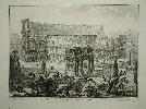
Imprint: Rome, c.1750
41 x 54 cms., with the usual paper crease along the middle where the paper was originally dried.
A classic Piranesi engraving of the Colosseum. Hind 56 st. 3 (of 6), a Rome edition
Stock number:2927.
ISBN:r
|
|
Imprint: Oxford, 1682-[86]
640 x 540 mm., trimmed close, with folds as issued, in good condition.
FIRST STATE. Robert Plot (1640-96) was the first keeper of the Ashmolean Museum in Oxford and official historiographer to James II. Following the success of Plot's first published work, the 'Natural History of Oxford', published in Oxford in 1677 he issued a work on Staffordshire. It has been described as being better written than that of Oxfordshire. Both were accompanied by large and extremely attractive maps of the counties. This map of Staffordshire is by Gregory King (1648-1712), engraved by Joseph Browne (fl.1678-82) and dated 1682. King (1648-1712) from Lichfield was a surveyor, draughtsman and engraver who went to London in 1672. There through the great engraver Wenceslaus Hollar he met John Ogilby and helped produce many of the road strips for his 'Britannia' in 1675. It is known from his autobiography that he had worked on a map of the county early on. It is an extremely ornate map decorated by numerous coats of arms of the subscribers. This is a good example of the FIRST STATE of five known, a very fine dark engraving. Provenance: private English collection. King (1988) pp. 25 & 66-8; Tooley Dictionary; Worms & Baynton-Williams (2011).
Stock number:7308.
|
|

Imprint: Oxford, 1677
500 x 480 mm., with very good modern outline colour to the map with wash to the coats or arms, with old folds as issued for inclusion in the book, with pinholes at double folds only visible when held to the light., short printers crease, one short repaired tear to right side 30 mm., repaired, otherwise in good condition.
This fine map is considered the most decorative ever published of the county of Oxfordshire. What makes it particularly striking are the 172 coats of arms surrounding the map. Those along the top border represent the eighteen University Colleges, the City of Oxford along with the University and four further towns within the county. The remainder belong to the gentry in the county. A few roads are shown which makes the map notable for being one of the earliest English county maps to depict any. It is engraved by Michael Burghers, who is noted for engraving the plates for David Loggans Oxonia Illustrata published two years earlier. The map illustrates Robert Plots The Natural History of Oxford-Shire a work noted for being one of the first to depict fossils. Plot was a Professor of Chemistry at the University and later would become the first Keeper of the Ashmolean Museum.
Stock number:6335.
|
|
|
Imprint: Oxford, 1677
495 x 480 mm., with very good modern outline colour to the map with wash to the coats or arms, with old folds as issued for inclusion in the book, in good condition.
This fine map is considered the most decorative ever published of the county of Oxfordshire. What makes it particularly striking are the 172 coats of arms surrounding the map. Those along the top border represent the eighteen University Colleges, the City of Oxford along with the University and four further towns within the county. The remainder belong to the gentry in the county. A few roads are shown which makes the map notable for being one of the earliest English county maps to depict any. It is engraved by Michael Burghers (1647?-1727), who is noted for engraving the plates for David Loggans Oxonia Illustrata published two years earlier. The map illustrates Robert Plots The Natural History of Oxford-Shire a work noted for being one of the first to depict fossils. Plot was a Professor of Chemistry at the University and later would become the first Keeper of the Ashmolean Museum. Provenance: Jonathan Potter 2008; private collection of Rodney Shirley. Worms & Baynton-Williams.
Stock number:9482.
|
|

Imprint: Venice, 1576
105 x 140 mm., on sheet with Italian text, complete with a second leaf of text describing the island. In good condition.
A lovely example of Tomaso Porcacchi's map of the island of Puerto Rico. This is one of the earliest obtainable maps of the island, one of only a handful published in the sixteenth century. The topographical detail although good is a little conceptual. It includes a decorative cartouche, four sea monsters and a compass rose upper left. St.Coix (Croce) in the Virgin Islands is depicted lower right. The map is printed by Simone Galignani and engraved by Girolamo Porro and first appeared in the enlarged second edition of 'L'Isole Piu Famose del Mondo' issued in 1576. The atlas is classed as an Isolario a term used to define an atlas of largely island maps. The tradition of the 'Isolario' began in the Mediterranean Sea and the first printed one appeared at the hands of Bartolommeo dalli Sonetti in c.1485. This was followed by the notable works of Benedetto Bordone in 1528 and Porcacchi. Phillips (1909-) 167; Sabin (1868) 64149; Shirley T.Por 1b no. 33.
Stock number:7046.
|
|

Imprint: Venice, 1572-[c.76]
105 x 140 mm., on sheet with Italian text, in good condition complete with accompanying pages of text.
A finely engraved map of the British Isles by Girolamo Porro which first appeared in Tomaso Porcacchi's 'L'Isole Piu Famose del Mondo' first published in Venice 1572. This example is from one of the following expanded editions. As might be expected for an Italian map the cartography draws more upon George Lily's exceedingly important map of 1546, rather than the more up to date Gerard Mercator wall map of 1564. Ireland though appears to derive from a third common source. In reducing the larger source map although Porro is recognised for his fine engraving here he accidentally omits London! Shirley British Isles 97; Shirley T.Por 1a no. 16.
Stock number:7045.
|
|

Imprint: Venice, Appresso Simone Galignani & Girolamo Porro, 1572
Edition: First Edition Quarto (290 x 205 mm.), in full later vellum binding, gilt panelled with gilt lettering. With engraved title page, woodcut printers device on the last leaf, woodcut head- and tailpieces and 30 engraved maps by Girolamo Porro set within the text. pp. (22), 117, (3). Light soiling to title page, gutter of first two leaves reinforced, text and border of the map of Venice coloured in red, without blank b6, some light soiling elsewhere, otherwise a good example.
The FIRST EDITION of Tomaso Porcacchis LIsole piu Famose del Mondo. It is printed by Simone Galignani and the engraver Girolamo Porro. This work is classed as an Isolario a term used to define an atlas of largely island maps. The tradition of the Isolario began in the Mediterranean Sea and the first printed one appeared at the hands of Bartolommeo dalli Sonetti in c.1485. This was followed by the notable works of Benedetto Bordone in 1528 and Porcacchi. The American section begins on page 101, which includes Porro's fine map of North America entitled Mondo Nuovo derived from the extremely rare and important Paolo Forlani map of the same printed in 1565 in Venice. It was the first printed map of North America and through this work by Porcacchi reached a wide audience. The Forlani is also the earliest map available to depict the Straits of Anian. Further interesting maps include one of Temistitan before its destruction by the Spanish. The atlas also includes a map of the East Indies Isole Molucche. The book concludes with two world maps at the end, one oval 'a finely-executed reduction of Camocios large world map of 1567 [&] a nautical map covering most of the world' (Shirley). Both depict a large southern continent. The text here provides brief details of navigation with some detail on the winds and currents of the world. Provenance: CSK.18.6.13.58. Adams P-1904; Burden (1996-2007) no. 42; Nordenskiold Collection (1981) no. 185; Phillips (1909-) 166; Sabin (1868) 64148; Shirley (1984) nos. 127-28; Shirley (2004) T.Por 1b; Tolias (2007). Isolarii, Fifteenth to Seventeenth in The History of Cartography volume 3 part 1 pp. 271-2; USTC 850883.
Stock number:9043.
|
|

Imprint: Venice, 1604
100 x 140 mm., with some light water staining to the margin, otherwise fine.
A good early map of the island of Madagascar beautifully engraved by Girolamo Porro from 'L'Isole Piu Famose del Mondo'. Shirley T.Por 1a no. 24.
Stock number:4967.
|
|
|
Imprint: Paris, c.1750
220 x 315 mm., with vertical fold as issued, in good condition.
An attractive copper engraved view of Tahiti. It appears in volume eight of the Abbe Prevost's 'Histoire Generale des Voyages'.
Stock number:9452.
|
|
|
Imprint: Paris, c.1750
220 x 315 mm., recent wash colour, with vertical fold as issued, in good condition.
An attractive copper engraved view of Tahiti. It appears in volume eight of the Abbe Prevost's 'Histoire Generale des Voyages'.
Stock number:9454.
|
|

Imprint: Boston, Printed by S. Kneeland and T. Green for D. Hencilman at the Corner Shop, the South Side of the Town-House & T. Hancock at the Bible and Three Crowns in Ann-Street, 1732
Binding: Hardback Tall 16mo (180 x 75 mm.), full contemporary calf, blind panelled, rebacked preserving original spine with blind ruled compartments. [2], vi, 220 pp., later endpapers, some occasional light foxing otherwise in good condition.
The first pocket sized road guide for the traveller in the North American colonies. This is the second edition following on from the first issued the previous year. The work is attributed to Thomas Prince because of an example of the work surviving at the Boston Public Library. The book is divided into six sections as outlined on the title page: I. Values of various commodities, II. Simple & Compound Interest, III. Names of Towns & Counties between Maine and Virginia with the times of Court sittings, IV. Times of General Meetings of Baptists & Quakers, V. Principal Roads between Kennebec (Maine) and Jamestown, Virginia, VI. Table of the Kings and Queens of England followed by various tables of Arithmetic and geography and a Directory of the streets of Boston including references to the various taverns and public houses. Provenance: Dorothy Sloan Auctions 21 November 1999 lot 56. Evans 3598; Howes P616; Sabin 98274.
Stock number:8909.
|
|
|
Imprint: London, W. Faden ... Charing Cross, 1 January 1779
c.1170 x 1270 mm., dissected and laid on contemporary linen, in fine early wash colour, with green silk edges, some of the lower edge loose or detached, with contemporary full calf slipcase, otherwise in good condition.
This map of the county of Leicestershire is the first of the county at the scale of one inch to the mile and is here offered in its FIRST STATE. It is one of the rarer of the eighteenth century surveys and is notable for the fact that unlike his major experienced competitors in this field, John Rocque and Thomas Jefferys, John Prior was a teacher, clergyman and mathematician. Despite this apparent lack of capability he was awarded the Silver Medal by the Society of Arts and 20 guineas. The survey itself was undertaken by Joseph Whyman from 1775-77 and lower right on the map we find, rather unusually, a complete triangulation of the county showing how the work progressed. It was published by Prior in 1779.On the map the parallel and meridian of Leicester are shown with the boundaries of the hundreds coloured. Turnpike roads have their Tollbars and Milestones identified. An indication of the importance of industry to this county is shown by the identification of Coal Pits, Lime Works, Wind Mills and Water Mills. The inset lower left is a detailed plan of the city of Leicester which was criticised for inaccuracies. Indeed it was excused for a lack of time to survey it properly. The whole map is engraved by John Luffman who completes it with a beautiful cartouche including both title and dedication to the Earl of Huntingdon. The apparent bucolic depiction in fact appears to bear a quantity of coal in front. Further editions were published in 1804 and 1819 and all are rare. Baum (1972) pp. 37-9; Deadman & Brooks (2010) p. 100; Harley (1965) pp. 56 & 63; Rodger (1972) no. 262.
Stock number:10396.
|
|
|
Imprint: London, William Dawson, London, I. Gregory, Leicester and Rev. John Prior, Ashby-de-la-Zouch, 1 January 1779
c.1170 x 1270 mm., dissected and laid on contemporary linen, in early wash colour, with silk edges lost, evenly toned, some light surface marks, one or two small areas of loss, with Faden's label pasted on the verso, otherwise in good condition.
This map of the county of Leicestershire is the first of the county at the scale of one inch to the mile and is here offered in its SECOND EDITION. It is one of the rarer of the eighteenth century surveys and is notable for the fact that unlike his major experienced competitors in this field, John Rocque and Thomas Jefferys, John Prior was a teacher, clergyman and mathematician. Despite this apparent lack of capability he was awarded the Silver Medal by the Society of Arts and 20 guineas. The survey itself was undertaken by Joseph Whyman from 1775-77 and lower right on the map we find, rather unusually, a complete triangulation of the county showing how the work progressed. It was published by Prior in 1779.On the map the parallel and meridian of Leicester are shown with the boundaries of the hundreds coloured. Turnpike roads have their Tollbars and Milestones identified. An indication of the importance of industry to this county is shown by the identification of Coal Pits, Lime Works, Wind Mills and Water Mills. The inset lower left is a detailed plan of the city of Leicester which was criticised for inaccuracies. Indeed it was excused for a lack of time to survey it properly. The whole map is engraved by John Luffman who completes it with a beautiful cartouche including both title and dedication to the Earl of Huntingdon. The apparent bucolic depiction in fact appears to bear a quantity of coal in front. John Prior died in 1803 and the map was acquired by Faden who issued this second edition. Further editions were published in 1804 and 1819 and all are rare. Baum (1972) pp. 37-9; Deadman & Brooks (2010) p. 100; Harley (1965) pp. 56 & 63; Rodger (1972) no. 262.
Stock number:10397.
|
|

Imprint: Augsburg, c.1765
360 x 1125 mm., two sheets joined as one, with minor margin tears and the two right side corners all professionally repaired, none effecting the image, otherwise in good condition.
During the eighteenth century the city of Augsburg became a significant centre of publishing. One of its specialities was a series of panoramic views published by the Probst family. They included engravers and publishers and began with Johann Balthasar Probst (1689-1750). He married the daughter of Jeremias Wolff an artist who published panoramic views. George Balthasar Probst (1732-1801) was one of several children who worked in the business and was also son-in-law to Mattheus Seutter the map maker. He specialised in optical views and town plans.This is a very attractive large panorama of the city of London which includes a detailed key identifying 70 notable buildings in German in the two insets in the upper corners, Latin lower right half and English in the lower left half. It extends from Somerset House in the west to the Tower of London in the east. The title above in a scrolled banner bears the Royal Arms and the City Crest either side of it. The Thames River is busy with various sized boats plying their trade. London Bridge is depicted burdened with large houses which were eventually cleared in 1756. According to Ralph Hyde this is the second state of 3 with the addition of 'No. 33 ...' lower centre. One other example is known to him at the British Library. Tooleys Dictionary.
Stock number:8226.
|
|

Imprint: Lyon, 1522-[41]
295 x 410 mm., in very good condition.
A very attractive early map of the British Isles projected in a trapezoidal style with rivers and towns noted, with Latin text on the verso. The author of the map is Laurent Fries a physician and geographer from Alsace. It is derived from that of Martin Waldseemuller published in Strasbourg in 1513. First published in 1522, by now Lorenz Fries had died. The blocks found their way into the possession of Melchoir and Gaspar Treschel. This edition was published in Lyon but printed in Vienne. Karrow, R.W. (16 c.) 28/2; Nordenskiold Collection 211 no. 1; Pastoureau Ptolemee F 1541 no. 2; Shirley 15 & 30; Shirley BL T.Ptol 7g.
Stock number:7407.
|
|

Imprint: Lyon, Melchoir and Gaspar Treschel, 1522-[35]
315 x 450 mm., with two minor stitch holes due to binding, both repaired, otherwise in good condition.
An attractive map of Ptolemaic Pakistan and Afghanistan. It is projected in a trapezoidal style with extensive rivers and mountain ranges. With Latin text on the verso. Laurent Fries produced the woodblocks for this 1535 edition of Ptolemy's Geography. By now Fries, whose maps were first issued in the 1522 edition, had died. The wood blocks found their way into the possession of Melchoir and Gaspar Treschel. For this edition published in Lyon the brothers asked Michael Servetus to re-edit the text. Karrow 28.24; Nordenskiold 209; Pastoureau Ptolemee E 1535; Shirley BL T.Ptol 7d.
Stock number:8022.
|
|

Imprint: London, 1625
300 x 340 mm., with tight margin along the left side from binding. One small split upper left with slight loss, another from a stitch lower left.
Although labelled 'Greneland' this map depicts Spitsbergen in the arctic. This reflects early English belief that the two were connected somewhere at more northern latitudes. English interest was awakened following Henry Hudson's voyage during which he noted an abundance of whales. It is flanked by whaling scenes at the sides and bottom. Samuel Purchas was a collector of records of voyages, theologian and author. The map is found in his 'Purchas His Pilgrimes .â¦' published in London by Henry Featherstone. It was a huge collection of records of voyages, many of which appear for the first time. This map accompanies the account of Robert Featherby who in 1613 accompanied the fleet of Benjamin Joseph to Spitsbergen. The following year 1614 he commanded a voyage on behalf of the Muscovy Company to nearby waters. There were a total of ten ships and two pinnaces one of which carried William Baffin. According to Purchas the map is attributed to Thomas Edge, a captain who made a number of whaling voyages to the region. The west coast depiction is derived from a similar map by Hessel Gerritsz from 1613. The images surrounding the map were most probably derived from Fotherby's watercolours, the 'Seamorses' refer to whales and walruses. Pool (2011) in IMCoS Journal no. 121 35-42; Schilder (2013) pp. 372-3; Shirley 'Atlases in the British Library' G.Pur 1a no. 43 (incorrectly identifying the map as Greenland); Wieder, F.C. (Spitsbergen) 45.
Stock number:4114.
|
|

Imprint: London, 1625
140 x 190 mm., in very good condition.
This attractive map of Persia or modern day Iran was first published in Jodocus Hondius' miniature version of Gerard Mercator's great atlas entitled the 'Atlas Minor'. Refer Van der Krogt, P. (Atlantes) 8200:351.
Stock number:4959.
|
|

Imprint: Cologne, 1600
210 x 280 mm., with some modern colour.
A fine example of the Matthias Quad map of Bavaria, Germany, engraved by Johann Bussemacher. Published in Cologne. Meurer "Atlantes Colonienses" Qua 15.
Stock number:4228.
|
|
|
Imprint: Cologne, Lambert Andreas, 1594
195 x 290 mm., in good condition.
A fine example of the Matthias Quad map of Bavaria, Germany, engraved by Johann Bussemacher. It was published in 'Europae Totius Orbis Terrarum' in 1594 and orientated with north at the top. It extends from Augsburg in the west to Passaw in the east. The city of Augsburg in the south east is also depicted. Meurer "Atlantes Colonienses" Qua 4 no. 15.
Stock number:9723.
|
|