|
|

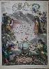
Imprint: London, 1676
55 x 90 mm., in good condition.
THE INCREDIBLY RARE REDMAYNE playing card, one of the most desirable of the early playing cards done of the English counties. There is only one recorded complete set of cards by William Redmayne's known to survive. They were published just three months after those of Robert Morden and advertised in the Trinity Term catalogue as being for sale by Redmayne at the Crown on Addle Hill; Henry Mortlock at the Phoenix, Robert Turner at the Star, in St. Pauls Church-yard; H. Cox in Holborn; and B. Billingsley at the Printing Press in Cornhill. Redmayne was a printer active between 1674 and 1719. In 1719 he was imprisoned for printing libel on the government and died in April in Newgate Prison of a fever. The maps on the Redmayne cards are smaller than those on the rival by Morden and are reminiscent of those thumb-nail maps by Matthew Simmons in 1635. Each map is accompanied by surrounding descriptive text on their respective commodities and points of interest. The Spade suit mark bears no numeration indicating it is the Ace in the suit. Provenance: collection of F. B. Swain, sold at Phillips, Norwich, 2 June 1993 lot 257; Burden Collection. Beresiner (2010) p. 18; not in Chubb; Hodson (1984) I no. 146; King (2003) p. 141; Kingsley (1982) no. 16; Mann, Sylvia and David Kingsley. (1972). 'Playing Cards Depicting maps of the British Isles, and of English and Welsh Counties', in The Map Collectors Circle, no. 87 pp. 3-4, 18-19, App. II no. 4, App. III no. 3. pl. xii (listing all the cards); Skelton 96.
Stock number:9100.
|
|
|
Imprint: London, Printed by J. Wallis, Berwick Street, Soho; and Published by W. H. Reid, Charing Cross, 1820
Binding: Hardback Octavo (120 x 80 mm.), recent full calf, ornate blind panelling to boards, spine with raised bands, blind ruled compartments, blue calf gilt title label. With engraved Contents, typographic title page with Index on verso (small paper fault), Address with Errata on the verso, two engraved divisional titles of England and Wales, pp. (4), 160, and 53 maps (1 general and 52 county maps) all in full original wash colour, omitting engraved title page and final leaf of postal charges, upper corners shaved, otherwise in good condition.
A VERY RARE CHARMING ATLAS. Little is known about William Henry Reid. A W. H. Reid is listed in 'Johnstone's London Commercial Guide' for 1818 as an 'Appraiser & auct. 32, Charing-cross'. Further research found a William Henry Reid listed in the Post Office London Commercial Directory for 1843 as 'architectural, engineering & scientific bookseller & publisher, 15 Charing Cross'. It is a reasonable assumption to conclude this is one and the same person. His name appears on the title page as publisher but many of the maps bear the imprints or James Wallis and C. Hinton. As Reids name does not appear on the maps they are often referred to as the Wallis-Reid maps. James Wallis (fl.1810-25) was born it is believed in Southampton in 1784. He was apprenticed to John Roper in 1799 and freed on 5 February 1811. It appears he started out as an engraver, becoming a bookseller, printer, stationer and publisher. He was at one point imprisoned for debt in 1835. Wallis had earlier produced the 'New British Atlas' in 1813 and 'Walliss New Pocket Edition' c.1812. His last atlas production was the plates for this work, 'The Panorama' of 1820. Several maps cite Wallis and Hinton as publisher which might indicate that towards the end of the project, they sold the rights to Reid whose imprint appears as sole publisher on the title page. Wallis retained the printing rights. We know Wallis became bankrupt later but maybe his financial difficulties began much earlier. Each map is accompanied by extensive descriptive text. A rare work, Chubb recorded 'the only copy I have seen is in the possession of Dr. F. B. Penfold'. Provenance: private English collection. Beresiner (1983) p. 234; Chubb (1927) 372; Tooley's Dictionary (1999-2004); Worms & Baynton-Williams (2011).
Stock number:9921.
|
|
|
Imprint: London, W. H. Reid, Charing Cross, 1820
Binding: Hardback Octavo (120 x 80 mm.), recent quarter calf, marbled paper boards, spine with gilt ruling top and bottom and gilt title. With engraved frontispiece title, engraved Contents, typographic title page with Index on verso, Address with Errata on the verso, two engraved divisional titles of England and Wales, pp. (4), 162, and 53 maps (1 general and 52 county maps) all in full original wash colour, tear to p. 113, water stain to Welsh half title, otherwise in good condition.
An early issue of this rare atlas. The instigators of this project appear to be James Wallis and Charles Hinton. The latter took over the address of 1 Ivy Lane in 1820, the premises of Thomas Crabb following his death in August 1819. Crabb's own set of county maps on card likely encouraged Hinton to follow suit. Here the style is very similar and many of the same errors of spelling are found in both. Little is known of Hinton beyond this one work, he is not even listed in the British Book Trade Index. To assist in the work, he brought in James Wallis (fl.1810-25). It appears he started out as an engraver, becoming a bookseller, printer, stationer and publisher. His earliest work appears to be 'Oddyâs New General Atlas of the World', published by Samuel Augustus Oddy (1779-1847) in 1811, with Wallis as the engraver. Wallis then produced the 'New British Atlas' in 1813 and 'Wallisâs New Pocket Edition' c.1812. This is his final atlas work. Twenty of the maps here include the imprints of Wallis and Hinton, in fact in equal numbers. As with earlier works, this identifies a 50-50 partnership. For some reason production struggled and a new partner was sought. As Wallisâ name is on the title page of the finished work as printer, it is unclear if he kept his share but Hinton certainly sold his. The remaining 32 maps were engraved without any imprint.The new partner was William Henry Reid and the finished maps are often referred to as those of âWallis-Reidâ. A W. H. Reid is listed in 'Johnstone's London Commercial Guide' for 1818 as an âAppraiser & auct. 32, Charing-crossâ. Further research found a William Henry Reid listed in the 'Post Office London Commercial Directory' for 1843 as âarchitectural, engineering & scientific bookseller & publisher, 15 Charing Crossâ. It is a reasonable assumption to conclude this is one and the same person. Each map has the mail coach roads coloured in red and is accompanied by extensive descriptive text. A rare work, Chubb recorded âthe only copy I have seen is in the possession of Dr. F. B. Penfoldâ. The work is undated but the latest found in the text is on p. 62 which refers to a resolution passed in the House of Commons on 12 July 1820. The Crabb plates had been acquired by Robert Miller and were issued as 'Millerâs new Miniature Atlas', without text. This gave the 'Panorama' the edge but in 1822 William Darton re-issued it with text also. Provenance: private English collection. Beresiner (1983) p. 234; Chubb (1927) 372; Tooley's Dictionary (1999-2004); Worms & Baynton-Williams (2011).
Stock number:10259.
|
|

Imprint: Valencia, Ortega, 1955
2380 x 1050 mm., printed in colour, with some holes at the double folds as might be expected otherwise in good condition.
A very large bull fighting promotional poster.
Stock number:8385.
|
|

Imprint: Vienna, 1796
590 x 730 mm., early wash colour.
Engraved by Jos. Stober. An inset of Northern Norway. From 'Grosse Deutscher Atlas'. Phillips 686; Dorflinger 'The first Austrian world atlases' in Imago Mundi 33.
Stock number:3185.
|
|
|
Imprint: Strasbourg, 1513
190 x 290 mm., woodcut, with light browning to top and bottom edges, with very minor lower fold splits repaired, otherwise in good condition.
Gregor Reisch (c.1470-1525) was an Abbot at the Carthusian Monastery in Freiburg and noted mathematician. He also studied Hebrew and geography and became Confessor to the Emperor Maximilian I. Whilst there he taught Martin Waldseemuller and Sebastian Munster. He was the author of one of the most popular books on moral and natural philosophy entitled the Margarita Philosophica first published in Freiburg in 1503. Their ensued several editions published in Freiburg, Strasbourg and Basel. Shirley identifies four different woodcut maps which appeared in these. Most of them include a Ptolemaic world map. Two of the maps are modern and include America. The first of these offered here is listed in Shirley as being a Strasbourg edition of the work printed by J. Gruninger in 1513. The earliest reference I can find is in Nordenskiolds Facsimile Atlas of 1889. Bagrow and Skelton refer to the same edition for the map in History of Cartography 1964. However, I have been unable to find a listing for this edition. Of all the maps found in Reischs Margarita, the two modern ones of 1513 and 1515 are least likely to be present and are thus the scarcest of those cited (Shirley).The map is very rare and if dated to 1513 takes on some significance as it displays both North and South America in the same year as Waldseemullers great Ptolemaic atlas was published. It is a simplified version of Waldseemullers magnificent twelve sheet wall map of the world published in 1507 surviving in just the one example. It is updated with the latest geography from the modern portion of the Ptolemy. This is particularly notable from the depiction of Asia and the presence of North America. Residing now at the Library of Congress it is famous for being the earliest to record America.The map breaks down the areas of the world with simple straight lines. Larger areas are named, smaller ones are letter keyed to a typographic table below the map. North and South America are connected by a land bridge but the only name appearing is paria seu prisilia referring to Brasilia. Provenance: private English collection for 40 years; Bagrow & Skelton (1964) p. 126; Nordenskiold (1889) Facsimile pp. 42, 70 & 92; Shirley (1993) no. 36 and 22; Shirley (2003) An Unusual Find, in IMCoS Journal 92 pp. 27-9; Tooley Dictionary.
Stock number:9149.
|
|

Imprint: London, [1819]
470 x 685 mm., this is a restrike from the original copper plate.
A very attractive detailed view of Newcastle from across the river on the Rope Walk, Gateshead. The print is engraved by the great Robert Havell. Thomas Miles Richardson (1784-1848) developed an early interest in drawing and later became a teacher of drawing at St. Andrews school in Newcastle. After six years he resigned to become an artist but struggled initially to gain work locally. Following exhibitions at the Royal Academy and the British Institution in London in 1814 his notoriety grew. He never lost his northern roots and continued to live and work in Newcastle. The first major art Exhibition in the north in 1822 was hosted at his own house at Brunswick Place. His success grew with founding of several Institutions in the north. This print was painted by Richardson from Gateshead looking across the river at the city. He employed the highly talented engraver Robert Havell to produce this fine high quality aquatint of it which Richardson published in 1819. This print is a restrike from the original copper plate produced in the 1980s on high quality paper.
Stock number:3548.
|
|
Imprint: Paris, 1757
Edition: First Edition 475 x 345 mm., in recent wash colour and in good condition.
This ornate title page is from the first edition of Robert de Vauguondy's 'Atlas Universel' published in 1757. Shirley 'Atlases in the BL' T.Robv-1b.
Stock number:8721.
|
|

Imprint: Paris, 1752
485 x 605 mm., in early outline colour, lower centrefold split repaired as often, otherwise in good condition.
A map of southern Russia by Didier Robert de Vaugondy in a state UNRECORDED by Pedley. In the first state of this map there is no inset of 'Nouvelle Servie' lower right. Pedley only refers to the one state. Refer Pedley 78.
Stock number:8895.
|
|

Imprint: London, 1849
360 x 490 mm., early wash colour, in good condition.
This image is arguably one of the most famous by David Roberts (1796-1864). It illustrates the Sphinx with a large evocative setting sun in the background. In the foreground are men with camels and an approaching caravan. It was published in Roberts' 'Egypt and Nubia' published 1846-9. He was the first British artist to sketch the monuments of Egypt. The lithographic stones were the work of Louis Haghe (1806-85) and were supposedly destroyed at the auction of final stock of prints. Abbey Travel 272.114; Tooley (1954) 402.
Stock number:8276.
|
|

Imprint: London, 1849
570 x 400 mm., with light foxing, otherwise in good condition.
David Roberts landmark 'Egypt and Nubia' was first published in parts between 1846-49. This map illustrates the route taken by Roberts on his travels through the region and appears in the second volume. Bourbon, Fabio (1996). 'Yesterday and Today. Egypt. Lithographs and Diaries by David Roberts, R. A.'.
Stock number:7618.
|
|
|
Imprint: London, c.1839
Binding: Hardback Folio (475 x 370 mm.), full recent blue cloth boards with gilt title to upper cover and spine, with original endpapers. With 43 (of 44) maps comprising three general of Ireland, Scotland and Wales (lacking that of England and Wales) and 40 maps of the English counties with that of Yorkshire being in two sheets, minor tissue repair to last two leaves, some light foxing, otherwise in good condition.
ONE OF ONLY TWO KNOWN EXAMPLES. T. Laurie Murray was a surveyor, publisher and founder member of the Royal Geographical Society. His major cartographic work was the English county atlas entitled 'An Atlas of the English Counties' first published in 1830. It contained forty-four maps engraved by Edward Hoare and James Reeves and identified Murray as the publisher. A second edition the following year involved the imprint dates being altered to each plate. The further history of the plates is murky, particularly after they left Murrays possession. William Robson is not even listed in the revised edition of 'Tooleys Dictionary of Mapmakers'. Some of the county bibliographies refer to him issuing later states of the respective county maps and one complete collection of the maps in this state exists in a private English collection. Robson issued commercial directories from 1819 to about 1842 and it appears also issued the Murray maps separately. From about 1838 he expanded into producing county directories, often bound along with that for London. According to Shaw and Tippers work on English and Welsh Directories, Robson published eight of them between the years of about 1838 and 1840. These covered all but the following counties: Leicestershire, Lincolnshire, Northamptonshire, Nottinghamshire, and Rutland in the midlands, and Cumberland, Northumberland and Westmoreland in the north. That of Lancashire is represented by Liverpool only, Staffordshire and Warwickshire by Birmingham and Yorkshire only by the West Riding and Sheffield. It is notable that the first eight counties above are the only ones lacking any imprint. This is the case in both known examples. Similarly, those of Wales, Scotland and Ireland are also omitted.His Directories were compilations of earlier publications including the Murray maps and were poorly assembled. This was a fiercely competitive arena and one in which it appears he suffered against the more professional and thorough opposition of the likes of James Pigot and Co. The most notable change to each map is the replacement of Murray's imprint with that of 'William Robson & Co Directory Office London'. Most county bibliographies do not record the imprint at all. Further revisions include those to the railway network and the addition of the poor law unions on each map. The Poor Law of 1834 brought about the grouping of local parishes to form Poor Law Unions, each with its own workhouse. No other example of this atlas could be located online, only the one example in a private collection is known. Beresiner (1983) pp. 164-5; Burgess (2009) 125/v; not in Carroll (1996); Hodson (1974) no. 90; not in Tooley's Dictionary.
Stock number:9803.
|
|
|
Imprint: London, Robson and Co., London Directory and Court Guide Office, 4 Cloak Lane, Cheapside, c.1845
Binding: Hardback Quarto (245 x 155 mm.), full contemporary cloth, ornate blind panelled boards, embossed gilt title to upper board, spine with blind ruling. With title page, pp. (2), 102, (2), 242, 30, Liverpool pagination 101-258, 301-466, with 3 large folding maps in early outline colour, each with binders' tears, otherwise in good condition.
T. Laurie Murray was a surveyor, publisher and founder member of the Royal Geographical Society. His major cartographic work was the English county atlas entitled 'An Atlas of the English Counties' first published in 1830. It contained forty-four maps engraved by Edward Hoare and James Reeves and identified Murray as the publisher. A second edition the following year involved the imprint dates being altered to each plate. The further history of the plates is murky, particularly after they left Murrays possession. William Robson is not even listed in the revised edition of 'Tooleys Dictionary of Mapmakers'. Some of the county bibliographies refer to him issuing later states of the respective county maps and one complete collection of the maps in this state exists in a private English collection. Robson issued commercial directories from 1819 to about 1842 and it appears also issued the Murray maps separately. In about 1838 he expanded into producing county directories. This was a fiercely competitive arena and one in which it appears he suffered against the more professional and thorough opposition. Hodson in his study of Hertfordshire identifies a work in the Guildhall Library entitled 'Robsons Commercial Directory of ... with a beautifully engraved map of each of the seven counties ... for 1839'. The makeup of this item appears to be similar. A search on Copac records a few Commercial Directories of individual and groups of counties. None are recorded for Cumberland, Northumberland, Westmoreland or Liverpool. The most notable change to each map is the removal of Murray's imprint. Further revisions include the addition of the poor law unions on each map. The Poor Law of 1834 brought about the grouping of local parishes to form Poor Law Unions, each with its own workhouse. The latest information however appears to be the railway network. The Maryport to Carlisle railway is illustrated which opened in 1845. Beresiner pp. 164-5; Burgess Kent 125/v; not in Carroll (1996); not in Higham (1997); Hodson (1974) no. 90; not in Tooley's Dictionary (1999-2004).
Stock number:9967.
|
|

Imprint: London, 1746-[53]
155 x 195 mm., with fine recent wash colour, light watermark upper right otherwise in good condition.
John Rocque was a Huguenot who at an early age settled in England. By 1734 he was a surveyor, engraver and publisher. His most important English county contribution was a series of maps first published in the 'English Traveller' in 1746. This is extremely rare and was followed by their inclusion in 'The Small British Atlas' , 1753. This is an example of the map of Cornwall in its second state with the incomplete erasure of the plate mark upper right as issued in the 1753 issue. Skelton-Hodson 198.
Stock number:7132.
|
|

Imprint: London, 1746-[53]
155 x 195 mm., in good condition.
John Rocque was a Huguenot who at an early age settled in England. By 1734 he was a surveyor, engraver and publisher. His most important English county contribution was a series of maps first published in the 'English Traveller' in 1746. This is extremely rare and was followed by their inclusion in 'The Small British Atlas' , 1753. This is an example of the map of Cornwall in its unnumbered state with the incomplete erasure of the plate mark upper right as issued in the 1753 issue. Quixley (1966) no. 28; Hodson 198.
Stock number:9261.
|
|

Imprint: London, John Rocque next the Duke of Grafton's Head, in Hide-Park-Road ... Printed by W. Edwards, 1746-[48]
Edition: First Edition Binding: Hardback Folio (540 x 370 mm.), recent half calf, marbled paper boards, spine with raised bands, gilt tooling to bands and compartments and red lettered title label, retaining original first blank endpaper. With title-page printed in red and black in English, Latin and French including an engraved vignette featuring the Arms of the City of London, a two-page list of subscribers and 16 double-page maps. One or two repairs in the lower margin or centrefold, some very light soiling, otherwise in good condition.
THE EARL OF ROSEBERY'S COPY OF AN EARLY STATE OF ROCQUE'S FAMOUS 16 SHEET SURVEY OF LONDON, NOT RECORDED in either Darlington & Howgego or Baynton-Williams. Jean Rocque (c.1704-62), to use his native name, was a Huguenot émigré who with his family settled in England by about 1709. By 1734 he was a surveyor, engraver and publisher and worked first in the region of Soho, a known centre for French emigrants. His next move was to the outskirts of London at the time in Piccadilly. His early work appears to be related to garden design as his brother Bartholomew was a landscape gardener. Indeed the region of Piccadilly at the time was renowned for its gardens, and suppliers of material for them. The connection to engraving possibly came about due to their cousin, also Bartholomew who worked as one in Mannheim, Germany. John Rocques earliest works reflect these beginnings many of which were of gardens or estates. The first was of Richmond Gardens, now Kew, in 1734.He progressed towards town plans as he noted these were poorly mapped, and with the burgeoning wealth of the time there was a growing demand for them. In conjunction with John Pine he began in 1737 work on a plan of London, obviously an enormous task it would be 1744 before it was finished. By then it appears that he had sold his partnership in the project to John Tinney. The finances were clearly strained; the final work in 24 sheets was published in October 1746. In 1741 Rocque began work on a further London survey this time taking in the environs. It is possible to surmise that it was about 1741 that Rocque relinquished his share in the 24 sheet plan. The environs would be of more value to Rocque as it covered many estates which would likely bring further business. The work for this map was completed in 1745 although the first sheet was published 13 February 1744. The remaining were issued over a period of months and completed around May of 1746 in 16 sheets, a few months prior to the 24 sheet map. Although this map is not to the same scale as the 24 sheet which is focused more on the city. It is in some ways more interesting as many of the present day inner suburbs are here fields and farms with small villages. These are all depicted at the large scale of five and half inches to the mile. The whole work measures 1450 x 1800 mm.'It is hard to understate Rocques importance. While other mapmakers had issued such large-scale maps before, no individual had attempted such a broad range. Perhaps more importantly, Rocque began work at a time when English mapmaking was at a low ebb, with much of the material being published being long out of date. His work made an enormous contribution to the impetus for what has been termed the Remapping of England' (Baynton-Williams).The map extends from Canonbury to Mile End, St. Georges Fields and Osterley. This state of the map is not recorded in Darlington and Howgego or Baynton-Williams. Neither reference work cites an example lacking the Latin and French titles which would later flank the English title above the map itself. However the map itself conforms to Darlington & Howgegos (D & H) second state, the first edition with the addition of Whitechapel Mount etc. This example bears a revised title dated 1748. It is not uncommon to find such a variation of content. The Earl of Rosebery (1847-1929) was a lifelong bibliophile and Prime Minister of the United Kingdom from 1894-95. A good example of one of the first and finest plans of London in the Georgian era. Provenance: with the bookplate of Archibald Philip Primrose, 5th Earl of Rosebery. He built 'one of the most remarkable book collections of his day, distributed amongst his libraries at Dalmeny, Barnbougle, Mentmore, the Durdens, Villa Rosebery, near Naples and his London residence in Berkeley Square' (Sotheby's Introduction to a catalogue of his books 29 October 2009). Barker, Felix & Jackson, Peter. (1990). The History of London in Maps pp. 54-65; Barber (2012) London pp. 110-11; Baynton-Williams, Ashley 26 (this state not listed); Darlington & Howgego (1964) no. 94 (this state not listed); ESTC N4897; ODNB; Varley, J. (1948). John Rocque: engraver, surveyor, cartographer and map-seller, in Imago Mundi, 5, 8391.
Stock number:8960.
|
|
|
Imprint: London, John Rocque [but Mary Ann Rocque], Chorographer to his Majesty, near Old Round Court in the Strand, 1764
Edition: First Edition Binding: Hardback Oblong quarto (210 x 260 mm.), full recent cloth binding, gilt embossed title to upper board. With the foreign maps from Salmon 20 (of 21), lacking England and Wales torn away; engraved title page in English and French and 53 (of 54) maps including 1 folding âParliamentary Map of England and Walesâ, a further general map of the counties, 49 maps of the counties and Ridings of England and Wales and 3 maps of the Islands, lacking Cheshire, soiling throughout, Suffolk with margin repair, final map of the islands in poor condition.
The plates for this atlas were first issued in Thomas Read's very rare English Traveller published in 1746 in only three volumes, the work was never completed. Jean Rocque (c.1704-62), to use his native name, was a Huguenot émigré who at an early age settled in England. By 1734 he was a surveyor, engraver and publisher. His work is renowned for its beauty as well as its accuracy and several important large scale maps were produced by him. Although undated there is plenty of evidence to place the first edition of John Rocqueâs Small British Atlas in 1753. Three issues of The Small British Atlas were published at this time, two of which are extremely rare. The next edition was dated 1762 and re-used the earlier engraved title page rather than a typographic one. According to Hodson this 1764 edition should retain the plate numbers but in some cases they have been erased. The final issue of these plates is in this state which was the work of P. Russell and Owen Price entitled England Displayed in 1769. This therefore may represent a late issue of the 1764. It is bound with the maps from Thomas Salmon's A New Geographical and Historical Grammar engraved by Thomas Jefferys. The Rocque atlas is advertised on the title priced at 7s. 6d. for uncoloured copies, coloured were offered for 10s. 6d. Chubb (1927) 209; not in ESTC; Hodson (1984-97) 202; not in BL refer Shirley (2004) T.Rocq 1a, G.Salm 3a (foreign atlas); Worms & Baynton-Williams (2011).
Stock number:10160.
|
|
|
Imprint: London, 1753
Edition: First Edition Binding: Hardback Small quarto (190 x 115 mm.), recent quarter calf, contemporary boards, blind ruled ribbed spine, with recent clam case box. With typographic title page in English and French and 54 maps, comprising 1 folding âParliamentary Map of England and Walesâ, a further general map of the counties, 42 maps of the counties and ridings of England, 7 Wales and 3 maps of the Islands, in good condition.
The plates for this atlas were first issued in Thomas Read's very rare English Traveller published in 1746 in only three volumes, the work was never completed. Jean Rocque (c.1704-62), to use his native name, was a Huguenot émigré who at an early age settled in England. By 1734 he was a surveyor, engraver and publisher. His work is renowned for its beauty and its accuracy and several important large scale maps were produced by him. Although undated there is plenty of evidence to place the first edition of John Rocqueâs Small British Atlas in 1753. The general parliamentary map of England is dated 1753, Rocque moved to the âOld Round Court in the Strandâ in 1753 and the ensuing edition of the work is also dated 1753. The original plates were revised by in most cases, the addition of a plate number upper right and the enhancing of one line of the double lined roads. Hodson details other revisions including some of the scale bars. Thomas Readâs large folding general map is replaced by another.Three issues of The Small British Atlas were published at this time. Of the first, just one example survives. The second edition is exceedingly rare and contained a newly engraved title page dated 1753, clearly indicating its issue later in the same year. Only three known examples survive. This 'third' edition dated 1753 includes a new typographic title page similarly worded but now including the imprint of Robert Sayer. The date for publication of the Small British Atlas may be deduced to be the summer of 1753 as Sayer placed a number of adverts commencing with the Public Advertiser on 11 June. It was priced at 7s. 6d. for uncoloured copies as stated on the title, coloured were offered for 10s. 6d. Chubb (1927) 207; ESTC T229345; Hodson (1984-97) 200; Worms & Baynton-Williams (2011).
Stock number:10155.
|
|

Imprint: Venice, Erhard Ratdolt, 1481
55 x 145 mm., set within a leaf of text measuring 270 x 195 mm., light browning upper left margin, two small wormholes, otherwise in good condition.
This is the second printed view of England, in two woodblocks. The 'Fasciculus Temporum' by Werner Rolewinck (1425-1502) was first published in Cologne, 1474. Although Shirley cites the image in the "Nuremberg Chronicle" by Hartmann Schedel he does not list this item which is of an earlier date. It was the first history of the world ever printed, published some twenty years before the better known Nuremberg Chronicle by Hartmann Schedel in 1493. Much of the history concerns itself with the biblical period but it was brought right up to date in this and later editions. It synthesises two chronological systems, that of Creation in year 1 and that of Christendom. All together there were some thirty-three incunabula editions. Indeed it is claimed that the Fasciculus is only the second printed book by a living author pre-dated only by Robertus Valturius' De Re Militari (1472). The 1474 edition includes the first view of an actual city in a printed book, that of Cologne identified by its unfinished cathedral. Most of the views in this and future editions were in fact imaginary and in some cases were used more than once. Rolewinck spent more than fifty years of his life in a Carthusian monastery in Cologne. None of the early editions contained a map. It was this same Venice edition by Erhard Ratdolt first published in 1480 which introduced a T-O map. The edition also introduced an imaginary view of "Britannia". The second edition of 1481 offered here also contained a view but printed from a different block. As elsewhere in the book the block was used to illustrate other towns. An early cataloguer remarked 'off hand I cannot think of an earlier printed book with an English view ...' The text is in 59 lines of Gothic type with red rubrication. The text on this leaf records the events between the years 194 and 224 AD. Cambell (Early Maps) believes that as printer of the T-O map of 1480 and the first illustrated edition of Pomponius Mela in 1482 Ratdolt may indeed have been the mapmaker and therefore also possibly the producer of these views. Provenance: Pickering & Chatto; private American collection. Refer Campbell nos.91 & 212 & p.221 D11; Goff R264; not in Shirley.
Stock number:8386.
|
|

Imprint: Frankfurt, 1595
Edition: First Edition 70 x 95 mm., in early wash colour.
A woodcut reduction of Braun & Hogenburg's plan of London. It is NOT RECORDED by Darlington and Howgego in their carto-bibliography of London plans. Adrien Romain (1561-1615) was born in Louvain in 1561 and became a noted mathematician, physician and priest. In 1595 he published the first edition of 'Parvum Theatrum Urbium sive Urbium Praecipuarum' a collection of town plans and birds'-eye views derived from Braun & Hogenberg's 'Civitates Orbis Terrarum' first issued in 1572. Here they are considerably reduced in size. A second edition appeared in 1608. Not in Darlington & Howgego (1964) no. 4; not in Fordham MCC 'Town Plans of the British Isles'; Phillips LC 65; Sabin 73000; Shirley BL T.Rom 1a no. 2; Tooley's Dictionary.
Stock number:8119.
|
|