|
|

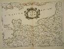
Imprint: Paris, 1654
Edition: First Edition 375 x 510 mm., early outline colour, light foxing in places, otherwise in good condition.
A fine map of northern England published in Paris by Pierre Mariette. It was first published separately in 1654 and introduced into the first edition of Nicolas Sanson's "Les Cartes Generales" in 1658. Nicolas Sanson was to bring about the rise of French cartography, although the fierce competition of the Dutch would last until the end of the century. This shift in cartographic centres shadowed the relative fortunes of the two countries; France under Louis XIV was a growing power in Europe. Born in Abbeville, in the Picardy region of France, 1600, Sanson studied history and turned to cartography as a means of recording it. In 1630 he was made Géographe Ordinaire du Roi, and was to become one of the tutors to Louis XIV. However, his future success was partly owing to the partnership he made with the publisher Pierre Mariette. In 1644 the latter had purchased the business of Melchoir Tavernier, and helped Sanson with financial support in producing the maps for the planned atlas. His atlas is the first full world atlas to be produced in France. This work had been in development for several years as the dates on the various maps attest. A fine example of the first state. Pastoureau Sanson Vb no. 23.
Stock number:7815.
|
|

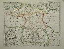
Imprint: Paris, 1652
37.5 x 53 cm. Very detailed map in original outline colour. Two wax marks.
Beautifully engraved map of Germany from Sanson's folio atlas entitled 'Cartes Generales de Toutes les Parties du Monde'. Shirley 'Atlases in the BL' T.San-2a; Pastoureau Sanson VB no. 133
Stock number:3402.
|
|

Imprint: Paris, 1648
Edition: First Edition 410 x 590 mm., early outline colour, a large map usually found with narrow margins as here, otherwise in good condition.
A lovely map of southern Italy illustrating the Straits of Messina between Sicily and the mainland. It was first published separately in 1648 as dated and introduced into the first edition of Nicolas Sanson's "Les Cartes Generales" in 1658. Sanson (1600-67) was to bring about the rise of French cartography, although the fierce competition of the Dutch would last until the end of the century. This shift in cartographic centres shadowed the relative fortunes of the two countries; France under Louis XIV was a growing power in Europe. Born in Abbeville, in the Picardy region of France, 1600, Sanson studied history and turned to cartography as a means of recording it. In 1630 he was made Géographe Ordinaire du Roi, and was to become one of the tutors to Louis XIV. However, his future success was partly owing to the partnership he made with the publisher Pierre Mariette. In 1644 the latter had purchased the business of Melchoir Tavernier, and helped Sanson with financial support in producing the maps for the planned atlas. His atlas is the first full world atlas to be produced in France. This work had been in development for several years as the dates on the various maps attest. A fine example of the first state. Pastoureau Sanson Va no. 79. Engraved by A. B. de la Plaets and published in Paris by Pierre Mariette. Pastoureau, M. Sanson V 80.
Stock number:7203.
|
|

Imprint: Paris, 1658-[79]
Edition: First Edition 370 x 440 mm., early outline colour in good condition.
This map of the Champagne and Brie region of France was published in Paris by Pierre Mariette. It appears in the first edition of Nicolas Sanson's "Les Cartes Generales" in 1658. Sanson was France's premier cartographer and helped to lift French work in this area to another level. His atlas is the first full world atlas to be produced in France. This work had been in development for several years as the dates on the various maps attest. Pastoureau Sanson Va no. 11; Phillips, P.L. (Atlases) 4260 no. 11.
Stock number:5579.
|
|

Imprint: Paris, 1665
400 x 500 mm., early outline colour in very good condition.
This map of part of Ukraine and the Crimean peninsula was published in Paris by Pierre Mariette. It appeared in Nicolas Sanson's 'Les Cartes Generales' first published in 1658. Sanson was France's premier cartographer and helped to lift French work in this area to another level. His atlas is the first full world atlas to be produced in France. This work had been in development for several years as the dates on the various maps attest. Pastoureau, M. Sanson V, 160; Phillips, P.L. (Atlases) 4260 no. 11.
Stock number:5575.
|
|
Imprint: Paris, P. Mariette, 1667
390 x 520 mm., early outline colour, light water stain lower margin, otherwise in good condition.
Engraved by R. Cordier this fine map displays the region of Normandy and the Channel Islands. ex 'Cartes Generales de Toutes les Parties du Monde'. Pastoureau Sanson V A no. 37; Shirley BL T.San-2a 21.
Stock number:3862.
|
|

Imprint: Paris, 1658-[65]
550 x 435 mm., early outline colour in good condition.
This map of the Piedmont region of Italy was published in Paris by Pierre Mariette. It centres on Turin and extends from Antibe on the French coast to Savona. Nicolas Sanson's 'Les Cartes Generales' was first published in 1658. This map was introduced in 1665, this example is a later state with the imprint altered to 'Chez l'Autheur'. Sanson was France's premier cartographer and helped to lift French work in this area to another level. His atlas is the first full world atlas to be produced in France. This work had been in development for several years as the dates on the various maps attest. Pastoureau Sanson Vb no. 147.
Stock number:8636.
|
|
Imprint: Paris, 1651
39 x 52.5 cms., early outline colour, good condition
Beautifully engraved by Jean Sommer this map is of the region around Paris. Pastoureau Sanson V B no. 127
Stock number:3135.
|
|

Imprint: Paris, P. Mariette., 1651.
42 x 55 cms., early outline colour. One small paper crease upper margin otherwise a superb example.
Engraved by R. Cordier this fine map displays the region of Languedoc in south western France extending from the Pyranees to the Rhone valley. Inland to the north west the cities of Toulouse and Cahors are displayed. From the 'Cartes Generales de Toutes les Parties du Monde'. Pastoureau Sanson V A no. 44.
Stock number:3863.
|
|

Imprint: Paris, 1693
440 x 570 mm., early outline colour, in good condition.
A particularly attractive map of France or ancient Gaul. It famously depicts the country before Louis XIV lost a third of his territory to mapmakers who concluded that the longitudinal width of the country was not as great as was depicted! Not in Pastoureau.
Stock number:6420.
|
|
Imprint: Utrecht, 1700
180 x 240 mm., in good condition.
Engraved by Antoine de Winter and published in 1700 in the Dutch edition of Sanson's 'L'Europe'. Pastoureau Sanson VIIG.
Stock number:5184.
|
|
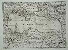
Imprint: Paris, 1655
37 x 53 cms., in early outline colour.
Engraved by Joannes Somer and published in Paris by Pierre Mariette this attractive map of central north Africa bears an ornate title cartouche top right. It is centred on Tunisia and Libya and includes the island of Malta in the Mediterranean. It comes from Sanson's 'Cartes Generales de Toutes les Parties du Monde'. Pastoureau Sanson V A no. 16.
Stock number:3952.
|
|

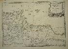
Imprint: Paris, 1665
400 x 490 mm., in fine early outline colour, in very good condition.
This map of northern Ireland was published in Paris by Pierre Mariette. It was first introduced in to a later edition of Nicolas Sanson's "Les Cartes Generales" in 1665. Nicolas Sanson was to bring about the rise of French cartography, although the fierce competition of the Dutch would last until the end of the century. This shift in cartographic centres shadowed the relative fortunes of the two countries; France under Louis XIV was a growing power in Europe. Born in Abbeville, in the Picardy region of France, 1600, Sanson studied history and turned to cartography as a means of recording it. In 1630 he was made Géographe Ordinaire du Roi, and was to become one of the tutors to Louis XIV. However, his future success was partly owing to the partnership he made with the publisher Pierre Mariette. In 1644 the latter had purchased the business of Melchoir Tavernier, and helped Sanson with financial support in producing the maps for the planned atlas. His atlas is the first full world atlas to be produced in France. This work had been in development for several years as the dates on the various maps attest. A fine example of the first state. Bonar-Law no. 11 st. 1; Pastoureau Sanson Vb no. 124.
Stock number:6991.
|
|

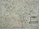
Imprint: Paris, 1658
370 x 435 mm., in fine early outline colour, good condition.
An attractive map of the whole of Wales first published in Nicolas Sanson's 'Les Cartes Generales de Toutes les Parties du Monde' in 1658. Sanson was France's premier cartographer and helped to lift the field onto another level during his career. With an attractive title cartouche lower left in a nice dark impression. The cartography is derived from that of John Speed and includes the neighbouring English counties including Herefordshire, Shropshire, Worcestershire, Cheshire, parts of Gloucestershire and Staffordshire. To the west the proximity of the Irish coast is depicted. Not in Booth; Pastoureau, M. Sanson V, 27; Roberts, Iolo & Menai Printed Maps of the whole of Wales 1573-1837 Part 1 in The Map Collector no. 68 pp. 34-9; Shirley, R.W. (BI to 1650) 506, pl. 80 st. 3.
Stock number:6460.
|
|

Imprint: Paris, 1654
Edition: First Edition 370 x 530 mm., in fine early outline colour, very good condition.
This map of the south western counties of England and South Wales was published in Paris by Pierre Mariette. It was first published separately in 1654 and introduced into the first edition of Nicolas Sanson's "Les Cartes Generales" in 1658. Nicolas Sanson was to bring about the rise of French cartography, although the fierce competition of the Dutch would last until the end of the century. This shift in cartographic centres shadowed the relative fortunes of the two countries; France under Louis XIV was a growing power in Europe. Born in Abbeville, in the Picardy region of France, 1600, Sanson studied history and turned to cartography as a means of recording it. In 1630 he was made Géographe Ordinaire du Roi, and was to become one of the tutors to Louis XIV. However, his future success was partly owing to the partnership he made with the publisher Pierre Mariette. In 1644 the latter had purchased the business of Melchoir Tavernier, and helped Sanson with financial support in producing the maps for the planned atlas. His atlas is the first full world atlas to be produced in France. This work had been in development for several years as the dates on the various maps attest. A fine example of the first state. Pastoureau Sanson Vb no. 26.
Stock number:6994.
|
|

Imprint: Paris, 1648
Edition: First Edition 410 x 590 mm., early outline colour, a large map usually found with narrow margins as here, a couple of foxmarks, otherwise in good condition.
A lovely map of southern Italy centred on the Kingdom of Naples. It was first published separately in 1648 as dated and introduced into the first edition of Nicolas Sanson's "Les Cartes Generales" in 1658. Sanson (1600-67) was to bring about the rise of French cartography, although the fierce competition of the Dutch would last until the end of the century. This shift in cartographic centres shadowed the relative fortunes of the two countries; France under Louis XIV was a growing power in Europe. Born in Abbeville, in the Picardy region of France, 1600, Sanson studied history and turned to cartography as a means of recording it. In 1630 he was made Géographe Ordinaire du Roi, and was to become one of the tutors to Louis XIV. However, his future success was partly owing to the partnership he made with the publisher Pierre Mariette. In 1644 the latter had purchased the business of Melchoir Tavernier, and helped Sanson with financial support in producing the maps for the planned atlas. His atlas is the first full world atlas to be produced in France. This work had been in development for several years as the dates on the various maps attest. A fine example of the first state. Pastoureau Sanson Va no. 79. Engraved by A. B. de la Plaets and published in Paris by Pierre Mariette. Pastoureau, M. Sanson V,79.
Stock number:7202.
|
|
Imprint: Paris, 1653
190 x 250 mm., early outline colour in good condition.
A fine attractive map of the region of present day Georgia, Armenia and Azerbaijan engraved for Nicolas Sanson's 'L'Asie'. Pastoureau Sanson IIIA no. 5.
Stock number:5391.
|
|
|
Imprint: Utrecht, 1683
190 x 230 mm., in good condition.
Engraved by Antoine de Winter and published in 1683 in the Dutch edition of Sanson's 'L'Asie'. Pastoureau Sanson IIIF no. 11.
Stock number:5400.
|
|

Imprint: Venice, 1784
480 x 580 mm., early outline colour. In very good condition. Good thick paper.
An attractive map of Russia with an ornate title cartouche. Santini was a Professor of design, an engraver and a mapmaker. The publisher is Giuseppe Antonio Remondini who re-issued Santini's original 'Atlas Universel'. The map is drawn from that of Robert de Vaugondy as stated in the title. Tooley's Dictionary.
Stock number:4076.
|
|

Imprint: Venice, 1776
475 x 590 mm., in early outline colour on strong paper with large margins.
This map of north western Spain displays the region of Galicia and Asturia and comes from Paolo Santini's 'Atlas Universel' first published in 1776. Cremonini 75; Tooley Dictionary.
Stock number:7787.
|
|