|
|

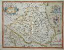
Imprint: London, 1607
Edition: First Edition 280 x 350 mm., in outline colour, with Latin text to the verso, some show through as usual, in good condition.
This map of Hertfordshire is from William Camdens 'Britannia' first published in 1586. It was the last to be published in his lifetime and the first to be illustrated with county maps although this had been contemplated since at least 1589. Camden (1551-1623) was an antiquary and historian. An academic by profession he would become the headmaster of Westminster School in 1593. He spent much of his time travelling and collecting material for his highly respected 'Britannia'. An example of the first edition first state. Chubb 18; Hodson 6.2; Shirley BL T.Camd 1a; Skelton 5; Taylor 'Late Tudor and Early Stuart Geography' pp. 9- 13.
Stock number:8090.
|
|

Imprint: London, 1607-[10]
Edition: First Edition 290 x 360 mm., in very good condition. In good modern wash colour.
The first printed map of Leicestershire from the first fully illustrated edition of William Camden's classic work, the 'Britannia'. An example of the FIRST state from the second edition. This is arguably the preferred issue as their is no text on the verso unlike the first edition which often shows through. Baum 'Leicestershire' p. 24; Skelton no. 6.
Stock number:4205.
|
|

Imprint: London, 1577-[c.1689]
Inscription: Signed, Inscribed Or Annotated 395 x 485 mm., early outline colour; short centrefold splits to upper and lower margin, small hole upper centre in the map, repaired, with very large margins, otherwise a fine example.
The original Saxton plate was prepared in 1577, the busiest year of production with twelve maps so dated. The presence of Saxtons name on the Burghley proof example led Evans and Lawrence to conclude that the Monmouth was one of those produced later in the year. The plate is unsigned and has not been attributed to any particular engraver. As explained above when Philip Lea acquired the maps he appears to have produced them in two distinct states. The earlier issue is dated to c.1689 and survives in just three known examples. This is an example of this RARE EARLIER STATE before the addition of the roads after John Ogilby and the arms of James Scott, Duke of Monmouth, which would occupy the right hand shield.Philip Lea flourished 1666-1700 as a cartographer, globe and instrument maker and map seller. His atlases were rarely uniform usually being made to order and his editions of Saxtons atlas are similarly varying in content although built around his stock of the original plates. These he acquired sometime around 1689, but from whom is unknown. The fate of some of the plates is unclear but two, Devon and Northumberland, never reappear suggesting that they might have been lost in the Fire. They were replaced by a plate engraved for Lea; that of Devon is signed by Francis Lamb and is offered here under Philip Lea. That of Essex appears to have been unavailable for reasons unknown as Lea issued another. However the original was eventually acquired as examples of Leas second edition often utilise the Saxton plate. Middlesex was first replaced by John Ogilbys plate of the county c.1673 which had been acquired by Lea. Then Lea acquired five countys published by John Seller which included a Middlesex, he tended to prefer Sellers version. Kent was not bought. Lea had acquired the county maps of Seller by 1693 as the Whitaker copy of the Saxton-Lea atlas can be securely dated to that year and contains the five maps. After acquisition of the Saxton plates Lea set about updating them for publication. This process involved extensive re-engraving of the old plates by incorporating new geographical and decorative material. However during this process some copies of the atlas were sold and two distinct issues have been identified with two different versions of the title page. The early edition dated to c.1689 survives in just three known examples. Lea gradually effected the alterations to the plates he desired which included converting the remaining Latin titles to English, the addition of crowns, crosses and mitres to represent various categories of town. Roads were added to the maps following the publication of John Ogilbys landmark 'Britannia' in 1675. Similarly Hundreds were added to the remaining maps as were town plans. The finished set of plates were completed by 1693 and represent their final cartographic form as only the imprints were altered after this date. In the finished form they also appeared in a French edition entitled 'Atlas Anglois contenant Les Cartes Nouvelles tres Exactes
' surviving in a unique example. Evans & Lawrence (1979) pp. 50-3, 61 & 160; Shirley (2004)) T.Sax 1h; Skelton (1970) nos. 110, 112 & 113.
Stock number:4265.
|
|

Imprint: London, 1574
340 x 490 mm., in early outline colour. With some light brown offsetting lower right corner, otherwise a good example with the early bunch of grapes watermark.
Saxtons map of Norfolk holds the position of being the first of the maps to be finished according to Evans and Lawrence. Only that of Oxfordshire was completed in the same year. This reflects both counties significance to Elizabethan England. They also show that the project was still in its infancy and its formula was still undergoing development. The Norfolk map includes all of the Hundreds as do four other counties including Cornwall. It is however the only one to letter them to a key upper right. This example is in the usual second state, the first being an early pre-issue. It is the only map engraved by Cornelis de Hooghe who was a pupil of Philip Galle in Antwerp and the only known work by him during his time in England. He famously claimed to be a natural son of Emperor Charles V (Charles I of Spain) and was executed in 1583 after being implicated in a plot against the life of William I, Prince of Orange (William the Silent). Christopher Saxton produced one of the earliest national surveys of any kind and the first uniformly conceived cartographic survey of England and Wales. It was begun in about 1574 and completed by 1579: in the long list of British atlases the first name is also the greatest, the name of Christopher Saxton (Chubb). Saxton (c.1542c.1610) was born in the Dunningley, West Riding of Yorkshire. While the details of his early life are sketchy, it is known that he attended Cambridge University, and in 1570 he was apprenticed as a map maker to John Rudd, vicar of Dewsbury. Saxton began work on his county maps in about 1574. In 1577 he received letters patent from Elizabeth I protecting his maps against plagiarism for the next ten years. As well as the Queens protection, Saxton also enjoyed the patronage of Thomas Seckford, Master of the Queens Requests, whose mottoes are found on the maps. Evans and Lawrence wrote that he left a legacy of maps of the counties of England and Wales from which succeeding generations of map-makers drew extensively
amazingly accurate in detail, [the atlas] survives as testimony to his expertise when surveying techniques and comprehension of the mathematical sciences were still limited. They are arguably the most highly prized by collectors of county maps. Barber Mapmaking in England, ca.1470-1650 in The History of Cartography volume 3 part 2 pp. 1623-31; Chubb (1927) I; Evans & Lawrence (1979) pp. 943; Frostick Norfolk 1.1 ; Harley, Brian The Map Collector no. 8 pp. 2-11; Hind (1952-55) vol. 1 p. 73; Lawrence, Heather Christopher Saxton in The Map Collector 27 pp. 16-18; Shirley (1980) no. 128; Shirley (2004) T.Sax 1b-e; Skelton (1970) 1.
Stock number:5052.
|
|

Imprint: London, 1607-[37]
28 x 36 cms., in fine condition
From the first fully illustrated edition of Camden's classic work, the 'Britannia'. An example of the third state. Refer to Skelton no. 5.
Stock number:3730.
|
|

Imprint: London, 1607-[10]
300 x 290 mm., in good condition.
This is from the sixth edition of William Camdens 'Britannia' first published in 1586. It was the last to be published in his lifetime and the first to be illustrated with county maps although this had been contemplated since at least 1589. Camden (1551-1623) was an antiquary and historian. An academic by profession he would become the headmaster of Westminster School in 1593. He spent much of his time traveling and collecting material for his highly respected 'Britannia'. The second printed map of Northumberland from the second fully illustrated edition of William Camden's classic work. An example of the first state without text on the verso. Chubb 18; Shirley BL T.Camd 1e; Skelton 5; STC 4508; Taylor 'Late Tudor and Early Stuart Geography' pp. 9- 13.
Stock number:5610.
|
|

Imprint: London, 1607
Edition: First Edition 260 x 310 mm., small split in lower margin, not affecting the image, with Latin text to the verso, in good condition.
The first printed map of Nottinghamshire from the first fully illustrated edition of William Camden's classic work, the 'Britannia'. An example of the FIRST STATE from the FIRST edition. Refer to Skelton no. 5.
Stock number:8217.
|
|

Imprint: London, 1607-[10]
260 x 310 mm., small split in lower margin repaired, otherwise in good condition.
The first printed map of Nottinghamshire from the first fully illustrated edition of William Camden's classic work, the 'Britannia'. An example of the FIRST STATE from the second and preferred edition of 1610 without text to the verso. Refer to Skelton no. 5.
Stock number:8218.
|
|

Imprint: London, 1578-[c.1749]
355 x 465 mm., early outline colour; signs of old folds, light water staining to the upper part of the map, not too noticeable from the front, otherwise a very good example.
Saxtons map of Pembroke was one of the last five engraved. A later edition of the map listed previously sold by George Willdey. In his possession George Willdey applied his imprint top centre; here it is removed with only faint remains by Thomas Jefferys. The impression is quite strong.Thomas Willdey successor to George Willdey died in 1748 and the business was closed as there were many creditors. It would seem logical to assume that it was sometime shortly after that Thomas Jefferys acquired them. Only two years earlier he had been appointed Geographer to the Prince of Wales and was just finding his feet. He began his esteemed career as an engraver and turned to publishing. No doubt these plates came his way at a tempting price. The atlas was not advertised and it would seem that Jefferys was content to sell the maps loose only binding a collection of the maps on request. Certainly this is supported by the fact that only FOUR EXAMPLES SURVIVE. An extremely rare edition. Evans & Lawrence (1979) pp. 53-8 & 163; Hodson (1984-97) I no. 184; Shirley (2004) T.Sax 1h.
Stock number:4266.
|
|

Imprint: London, 1578-[1645]
355 x 465 mm. Uncoloured, light age toning to the margins, a centrefold split in the lower margin and a short tear, again in the lower margin, both repaired with old paper, both short of the image, otherwise a very good example.
Evans and Lawrence speculate that the surveying of Pembroke was one of the very last counties undertaken. The majority of the Welsh counties were surveyed in 1578. It is unsigned by any engraver and it would be hard to suggest anyone. This is one county map in which Web did not anglicise the title, only the date change can be noted.William Web (fl.1629-52) was a bookseller from Oxford. In 1645 he published 'The Maps of all the Shires in England and Wales. Exactly taken and truly described by Christopher Saxton'. The imprint states 'Printed for William Web at the Globe in Cornehill, London', despite Web being a bookseller in Oxford. Quite how he came into possession of the Saxton plates is unknown. The fact that the court of Charles I was in Oxford for the duration of the Civil War (1642-46) and the atlas is dedicated to the King can be no coincidence. The war undoubtedly caused a delay as most maps bear the date of 1642 despite the title imprint being 1645. Because it did not have the same impact and no doubt because of the Civil War this edition of Saxtons atlas is one of the rarest surviving in ONLY THREE RECORDED EXAMPLES. Evans & Lawrence (1979) pp. 45-7; Shirley Atlases in the BL T.Sax 1g; Skelton (1970) 27.
Stock number:4268.
|
|
|
Imprint: London, George Willdey at the Great Toy Spectacle, China-ware, and Print Shop, ye Corner of Ludgate Street near St. Paul's, 1579-[c.1732]
Inscription: Signed, Inscribed Or Annotated 365 x 470 mm., in early outline colour, browning in the margin due to early mount, otherwise in good condition.
A fine example of one of the rarest states of the Christopher Saxton map of Radnor, Brecon, Cardigan and Caermarthen. With inset plans of Caermarthen, Breknoke, Radnor and Cardigan. Only five examples of the atlas survive. At first glance one might be inclined to think this is the Philip Lea edition however closer examination reveals the presence of George Willdey's imprint lower right. The date of the death of Philip Leas widow Anne is unknown but on 5 August 1730 the "Daily Journal" carried an advertisement announcing the sale by auction of "all the Copper Plates belonging to the Estate of Mrs. Anne Lea, deceased ... with all the County Maps of Great Britain and Ireland". From 1709 early in his career Willdey was advertising maps for sale. Willdeys first advertisement announcing the county plates was placed in the Daily Post for 3 February 1732 (illustrated in Hodson I p. 142). They were sold individually for 4d. each. In none his adverts up to his death in November 1737 does he mention the county maps be bound as an atlas with a title-page. However in 1721 when advertising his series of two sheet maps he stated that This Set of Maps may be fitted up several ways and sizes, or bound in a Book, or sold single, to fit Gentlemens Conveniency ... It can be assumed that he would be just as accommodating with the single sheet county maps and that therefore a c.1732 date is reasonable for the atlas.Willdeys last advert was placed in the 'Daily Post', 12 November 1737, which carried in its news columns the announcement that Yesterday Morning died of an Apopletick Fit, Mr. Willdey, who kept the noted great Toyshop at the Corner of Ludgate-street by St. Pauls; said to have died very rich. Curiously although all the newspapers agreed he died on 11 November his will is signed 12 November. The business was continued by Thomas Willdey although it is not clear whether this his Georges brother, or son. Thomas died in 1748 and the business was closed as there were many creditors. Hodson I no. 183; Shirley 'Atlases in the British Library', T.Sax 1j; Worms & Baynton-Williams (2011).
Stock number:10063.
|
|

Imprint: London, 1607-[10]
275 x 340 mm., in good condition.
This is from the sixth edition of William Camdens 'Britannia' first published in 1586. It was the last to be published in his lifetime and the first to be illustrated with county maps although this had been contemplated since at least 1589. Camden (1551-1623) was an antiquary and historian. An academic by profession he would become the headmaster of Westminster School in 1593. He spent much of his time travelling and collecting material for his highly respected 'Britannia'. The second printed map of Shropshire from the second fully illustrated edition of William Camden's classic work. An example of the first and only state. Chubb 18; Shirley BL T.Camd 1e; Skelton 5; STC 4508; Taylor 'Late Tudor and Early Stuart Geography' pp. 9- 13.
Stock number:7498.
|
|

Imprint: London, 1577-[1645]
390 x 505 mm., a couple of areas of minor loss to the extreme right margin, otherwise in good condition.
Surveyed in 1577 by Christopher Saxton this map remains a classic to this day. It was engraved by Remigius Hogenberg whose imprint is lower left. Hogenberg was a native of Mechelen and brother to the famous Frans Hogenberg who co-published the Civitates Orbis Terrarum. Christopher Saxton had just received his licence which encouraged him to produce 12 maps this year, the busiest. Those produced later in the year most likely after his licence was approved are only known in the one state with Saxton's name present. Those issued in the first part of the year including this one are known in 'proof' states lacking his name. Christopher Saxton produced one of the earliest national surveys of any kind and the first uniformly conceived cartographic survey of England and Wales. It was begun in about 1574 and completed by 1579: in the long list of British atlases the first name is also the greatest, the name of Christopher Saxton (Chubb). Saxton (c.1542c.1610) was born in the Dunningley, West Riding of Yorkshire. While the details of his early life are sketchy, it is known that he attended Cambridge University, and in 1570 he was apprenticed as a map maker to John Rudd, vicar of Dewsbury. Saxton began work on his county maps in about 1574. In 1577 he received letters patent from Elizabeth I protecting his maps against plagiarism for the next ten years. As well as the Queens protection, Saxton also enjoyed the patronage of Thomas Seckford, Master of the Queens Requests, whose mottoes are found on the maps. Evans and Lawrence wrote that he left a legacy of maps of the counties of England and Wales from which succeeding generations of map-makers drew extensively
amazingly accurate in detail, [the atlas] survives as testimony to his expertise when surveying techniques and comprehension of the mathematical sciences were still limited. They are arguably the most highly prized by collectors of county maps. William Web (fl.1629-52) was a bookseller from Oxford. In 1645 he published 'The Maps of all the Shires in England and Wales. Exactly taken and truly described by Christopher Saxton'. The imprint states 'Printed for William Web at the Globe in Cornehill, London', despite Web being a bookseller in Oxford. Quite how he came into possession of the Saxton plates is unknown. The fact that the court of Charles I was in Oxford for the duration of the Civil War (1642-46) and the atlas is dedicated to the King can be no coincidence. The war undoubtedly caused a delay as most maps bear the date of 1642 despite the title imprint being 1645. Because it did not have the same impact and no doubt because of the Civil War this edition of Saxtons atlas is one of the rarest surviving in ONLY THREE RECORDED EXAMPLES. Provenance: private English collection. Barber Mapmaking in England, ca.1470-1650 in The History of Cartography volume 3 part 2 pp. 1623-31; Chubb (1927) I; Evans & Lawrence (1979) pp. 943, 45-7 & 59 no. 2; Harley, Brian 'The Map Collector' no. 8 pp. 2-11; Hind (1952-55) vol. 1 p. 73; Lawrence, Heather Christopher Saxton in 'The Map Collector' 27 pp. 16-18; Shirley (1980) no. 128; Shirley (2004) T.Sax 1g; Skelton (1970) 27; Worms & Baynton-Williams (2011).
Stock number:7331.
|
|

Imprint: London, 1575-[79]
390 x 510 mm., early wash colour, very light offsetting otherwise in very good condition.
Christopher Saxtons map of the county of Somerset is one of the earliest he produced. Only two were made in 1574 and according to Evans and Lawrence this was most likely one of the last to be prepared in the year 1575. Progress was still slow at this stage operating as he was without an official licence for support. It was engraved by Lenaert Terwoort whose imprint is lower left, he was one of a number of Dutch engravers of the work and apart from the five maps he contributed and that he originated from Antwerp little is known of him. This example is in the usual finished state, the earlier one being pre-issue.Christopher Saxton produced one of the earliest national surveys of any kind and the first uniformly conceived cartographic survey of England and Wales. It was begun in about 1574 and completed by 1579: in the long list of British atlases the first name is also the greatest, the name of Christopher Saxton (Chubb). Saxton (c.1542c.1610) was born at Dunningley in the West Riding of Yorkshire. While the details of his early life are sketchy, it is known that he attended Cambridge University, and in 1570 he was apprenticed as a map maker to John Rudd, vicar of Dewsbury. Saxton began work on his county maps in about 1574. In 1577 he received letters patent from Elizabeth I protecting his maps against plagiarism for the next ten years. As well as the Queens protection, Saxton also enjoyed the patronage of Thomas Seckford, Master of the Queens Requests, whose mottoes are found on the maps. Evans and Lawrence wrote that he 'left a legacy of maps of the counties of England and Wales from which succeeding generations of map-makers drew extensively
amazingly accurate in detail, [the atlas] survives as testimony to his expertise when surveying techniques and comprehension of the mathematical sciences were still limited.' They are arguably the most highly prized by collectors of county maps. Barber (2007) pp. 1623-31; Chubb (1927) I; Evans & Lawrence (1979) pp. 943; Harley, Brian The Map Collector no. 8 pp. 2-11; Hind (1952-55) vol. 1 p. 73; Lawrence, Heather Christopher Saxton in The Map Collector 27 pp. 16-18; Needell (1995) p. 192; Shirley (1991) no. 128; Shirley (2004) T.Sax 1b-e; Skelton (1970) 1.
Stock number:9079.
|
|
|
Imprint: London, 1607-[10]
275 x 385 mm, with some discolouration to centrefold, mild paper crease lower right, otherwise in good condition.
Highly decorative, and desirable early county map. This example is from the preferred second edition of William Camden's 'Britannia' of 1610. here the text is omitted from the verso and the map is still in its first state before the addition of a plate number. Needell (1995) 23; Skelton (1970) 5.
Stock number:3075.
|
|

Imprint: London, 1575-[1693]
385 x 440 mm., with an old repair to lower centrefold split 30 mm. into the map, otherwise in good condition.
Christopher Saxtons map of the county of Hampshire is one of the earliest he produced, two were made in 1574 and according to Evans and Lawrence only two or three maps were likely to have preceded it in 1575. It was engraved by Lenaert Terwoort, he was one of a number of Dutch engravers of the work and apart from the five maps he contributed and that he originated from Antwerp little is known of him. Saxton produced one of the earliest national surveys of any kind and the first uniformly conceived cartographic survey of England and Wales. It was begun in about 1574 and completed by 1579: in the long list of British atlases the first name is also the greatest, the name of Christopher Saxton (Chubb). Evans and Lawrence wrote that he left a legacy of maps of the counties of England and Wales from which succeeding generations of map-makers drew extensively
amazingly accurate in detail, [the atlas] survives as testimony to his expertise when surveying techniques and comprehension of the mathematical sciences were still limited. They are arguably the most highly prized by collectors of county maps. Philip Lea flourished 1666-1700 as a cartographer, globe, instrument maker and mapseller. His atlases were rarely uniform usually being made to order and his editions of Saxtons atlas are similarly varying in content, although built around his stock of the original plates. These he acquired sometime around 1689, but from who is unknown. After acquisition Lea set about updating them for publication. This process involved extensive re-engraving of the old plates by incorporating new geographical and decorative material. However during this process some copies of the atlas were sold and two distinct issues have been identified with two different versions of the title page. The early edition dated c.1689 survives in just three known examples. Lea gradually effected the alterations to the plates he desired which included converting the remaining Latin titles to English, the addition of crowns, crosses and mitres to represent various categories of town. Roads were added to the maps following the publication of John Ogilbys landmark Britannia in 1675. Similarly Hundreds were added to the remaining maps as were town plans. The finished set of plates was complete by 1693 and represents their final cartographic form as only the imprints were altered after this date. In the finished form they also appeared in a French edition entitled Atlas Anglois contenant Les Cartes Nouvelles tres Exactes
surviving in a unique example. Provenance: private English collection. Barber (2007) pp. 1623-31; Chubb (1928) I; Evans & Lawrence (1979) pp. 943, 50-3, 63 & 159; Harley, Brian The Map Collector no. 8 pp. 2-11; Hind (1952-55) vol. 1 p. 73; Lawrence, Heather Christopher Saxton in The Map Collector 27 pp. 16-18; Shirley (1991) no. 128; Shirley (2004) T.Sax 1h; Skelton (1970) nos. 110, 112 & 113; Worms & Baynton-Williams (2011).
Stock number:7309.
|
|

Imprint: London, George Willdey, 1575-[c.1732]
Inscription: Signed, Inscribed Or Annotated 410 x 550 mm., early outline colour, laid down on paper, small area of loss centre left, toned overall.
Christopher Saxtons plate of the south-east, including Kent, Surrey and Sussex, was quite likely the first of the six to be produced in 1575 as he worked his way westwards along the south coast. It was the work of the engraver Remigius Hogenberg and was replaced by maps of the individual counties around 1693 by Philip Lea. The original plate however was somehow not destroyed although one would assume the sales were dramatically less and the number of surviving copies reflects this. The date of the death of Philip Leas widow Anne is unknown, but on 5 August 1730 the 'Daily Journal' carried an advertisement announcing the sale by auction of "all the Copper Plates belonging to the Estate of Mrs. Anne Lea, deceased ... with all the County Maps of Great Britain and Ireland". From 1709 early in his career Willdey was advertising maps for sale. Willdeys first advertisement announcing the county plates was placed in the 'Daily Post' for 3 February 1732 (illustrated in Hodson I p. 142). They were sold individually for 4d. each. In none his adverts, up to his death in November 1737, does he mention the county maps be bound as an atlas with a title-page. However in 1721 when advertising his series of two sheet maps he stated that This Set of Maps may be fitted up several ways and sizes, or bound in a Book, or sold single, to fit Gentlemens Conveniency ... It can be assumed that he would be just as accommodating with the single sheet county maps and therefore a c.1732 date is reasonable for the atlas.Willdeys last advert was placed in the Daily Post, 12 November 1737, which carried in its news columns the announcement that Yesterday Morning died of an Apopletick Fit, Mr. Willdey, who kept the noted great Toyshop at the Corner of Ludgate-street by St. Pauls; said to have died very rich. Curiously although all the newspapers agreed he died on 11 November his will is signed 12 November! The business was continued by Thomas Willdey although it is not clear whether this is Georges brother, or son. Thomas died in 1748 and the business was closed as there were many creditors. Burgess (2009) no. 1.viii; Evans & Lawrence (1979) pp. 12, 53-8 & 160; Hodson (1984-97) I no. 183; Kingsley 1.8; Shirley (2004) T.Sax 1j; Worms & Baynton-Williams (2011).
Stock number:7313.
|
|

Imprint: London, 1576-[1693]
400 x 525 mm., early outline colour, in excellent condition.
Christopher Saxtons map of the counties of Northamptonshire, Bedfordshire, Huntingdonshire and Rutland. These counties were surveyed early in 1576 according to Evans and Lawrence but the engraver is unknown. Saxton produced one of the earliest national surveys of any kind and the first uniformly conceived cartographic survey of England and Wales. It was begun in about 1574 and completed by 1579: in the long list of British atlases the first name is also the greatest, the name of Christopher Saxton (Chubb). Evans and Lawrence wrote that he left a legacy of maps of the counties of England and Wales from which succeeding generations of map-makers drew extensively
amazingly accurate in detail, [the atlas] survives as testimony to his expertise when surveying techniques and comprehension of the mathematical sciences were still limited. They are arguably the most highly prized by collectors of county maps. Philip Lea flourished 1666-1700 as a cartographer, globe, instrument maker and mapseller. His atlases were rarely uniform usually being made to order and his editions of Saxtons atlas are similarly varying in content although built around his stock of the original plates. These he acquired sometime around 1689, but from who is unknown. After acquisition Lea set about updating them for publication. This process involved extensive re-engraving of the old plates by incorporating new geographical and decorative material. However during this process some copies of the atlas were sold and two distinct issues have been identified with two different versions of the title page. The early edition dated to c.1689 survives in just three known examples. Over the years the plate had been updated. For the ill-fated c.1665 edition town plans of Northampton, 'Oukham', Huntington, 'Bedforde' and 'Peterburgh' were added, all after those of John Speed. For the final Lea edition roads have been added. Lea gradually effected the alterations to the plates he desired which included converting the remaining Latin titles to English, the addition of crowns, crosses and mitres to represent various categories of town. Roads were added to the maps following the publication of John Ogilbys landmark Britannia in 1675. Similarly Hundreds were added to the remaining maps as were town plans. The finished set of plates was complete by 1693 and represents their final cartographic form as only the imprints were altered after this date. In the finished form they also appeared in a French edition entitled Atlas Anglois contenant Les Cartes Nouvelles tres Exactes
surviving in a unique example. Chubb (1928); Evans & Lawrence (1979) pp. 13, 50-3, 63 & 160; Shirley (2004) T.Sax 1h; Skelton (1970) nos. 110, 112 & 113; Worms & Baynton-Williams (2011).
Stock number:7303.
|
|
Imprint: London, 1576-[1645]
Inscription: Signed, Inscribed Or Annotated 375 x 680 mm., old but not early wash colour, small split along the green colour on left side, the whole backed with paper.
The map of Durham is one of the five signed by Augustine Ryther as engraver and was surveyed during 1576 along with the other northern counties. Speculation surrounds the origins of Ryther. Ralph Thoresby stated in 1715 that he was probably of Leeds and may well indeed be related to the ennobled family of that name from Yorkshire. He was one of the earliest English born copper plate engravers and signed five of Saxtons maps. It is quite likely he was the author of others. He went on to collaborate on the sale of the Saxtons atlas. Certainly there is evidence to show that he continued to sell it after the Saxtons ten-year privilege expired. His finest works are the plates for Robert Adams depicting the Spanish Armada published in 1590. Ryther was however in debtors prison for the winter of 1594-95 and thereafter there is no record. This map is one of a handful for which Web altered the title from Latin to English. Both the arms and cipher of Elizabeth I are replaced by those of Charles I and the gryphon is replaced by a unicorn. William Web (fl.1629-52) was a bookseller from Oxford. In 1645 he published 'The Maps of all the Shires in England and Wales. Exactly taken and truly described by Christopher Saxton'. The imprint states 'Printed for William Web at the Globe in Cornehill, London', despite Web being a bookseller in Oxford. Quite how he came into possession of the Saxton plates is unknown. The fact that the court of Charles I was in Oxford for the duration of the Civil War (1642-46) and the atlas is dedicated to the King can be no coincidence. The war undoubtedly caused a delay as most maps bear the date of 1642 despite the title imprint being 1645. Because it did not have the same impact and no doubt because of the Civil War this edition of Saxtons atlas is one of the rarest surviving in ONLY THREE RECORDED EXAMPLES. Evans & Lawrence (1979) pp. 45-7; Shirley Atlases in the BL T.Sax 1g; Skelton (1970) 27; Worms & Baynton-Williams (2011).
Stock number:3022.
|
|

Imprint: London, 1607-[10]
285 x 315 mm., outline colour with wash colour to the cartouche, small area of loss repaired in upper margin not affecting the image, otherwise in good condition.
From the first fully illustrated edition of William Camden's classic work, the 'Britannia'. An example of the first state from the second edition. Refer to Skelton no. 5.
Stock number:5984.
|
|