|
|
Imprint: London, Robert Sayer, 1731-[74]
310 x 800 mm., margins trimmed but still ample.
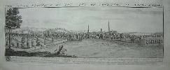
The second state as usual with the plate number 18 engraved top right. The brothers Samuel and Nathaniel Buck were born in Richmond, North Yorkshire and became interested in sketching town prospects because of Ralph Thoresby, a local antiquary. From 1719 they produced and published a series of views of towns in the north of England. Each was available to subscribers for between 2 and 5 shillings each. They soon outgrew the north and moved south to London. Their tours to sketch were prepared well in advance, potential subscribers being contacted before hand usually through local press. The following summer season would be when the view was prepared. On occasions other artists were employed to enhance the foreground image and bring it to life. Infrequently two prospects were designed to pair together such as those of Deptford and Greenwich and Chatham and Rochester. This created a longer panorama with greater impact. At the end of the season they would return to London and began the process of engraving. Nathaniel Buck died in 1756 and in 1774 Robert Sayer acquired the copper plates from Samuel and published them as 'Buck's Antiquities', a magnificent three volume work. In 1779 Samuel Buck died. Their perspective panoramic views have never been surpassed and are a very valuable record of a pre-industrial Britain. No other series of views ever published was as extensive or detailed. They provided the model for numerous derivatives including the inset views to Emanuel Bowen and Thomas Kitchin's 'Large English Atlas' c.1755, Robert and James Dodsley's 'England Illustrated' 1764, Nathaniel Spencer's 'Complete English Traveller' 1773, George Walpoole's 'new & Complete English Traveller' 1784 and the European, London and Universal Magazines from the 1750s. The second state as usual with the plate number 18 engraved top right. Hyde 'A Prospect of Britain'.
Stock number:3648.
|
|
Imprint: London, Robert Sayer, 1746-[74]
310 x 800 mm., margins trimmed slightly but still ample, very light paper crease to left of centre, otherwise in very good condition.
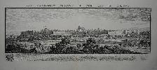
The second state as usual with the plate number 12 engraved top right. The brothers Samuel and Nathaniel Buck were born in Richmond, North Yorkshire and became interested in sketching town prospects because of Ralph Thoresby, a local antiquary. From 1719 they produced and published a series of views of towns in the north of England. Each was available to subscribers for between 2 and 5 shillings each. They soon outgrew the north and moved south to London. Their tours to sketch were prepared well in advance, potential subscribers being contacted before hand usually through local press. The following summer season would be when the view was prepared. On occasions other artists were employed to enhance the foreground image and bring it to life. Infrequently two prospects were designed to pair together such as those of Deptford and Greenwich and Chatham and Rochester. This created a longer panorama with greater impact. At the end of the season they would return to London and began the process of engraving. Nathaniel Buck died in 1756 and in 1774 Robert Sayer acquired the copper plates from Samuel and published them as 'Buck's Antiquities', a magnificent three volume work. In 1779 Samuel Buck died. Their perspective panoramic views have never been surpassed and are a very valuable record of a pre-industrial Britain. No other series of views ever published was as extensive or detailed. They provided the model for numerous derivatives including the inset views to Emanuel Bowen and Thomas Kitchin's 'Large English Atlas' c.1755, Robert and James Dodsley's 'England Illustrated' 1764, Nathaniel Spencer's 'Complete English Traveller' 1773, George Walpoole's 'new & Complete English Traveller' 1784 and the European, London and Universal Magazines from the 1750s. The second state as usual with the plate number 12 engraved top right. Hyde 'A Prospect of Britain'.
Stock number:3649.
|
|
Imprint: Paris, c.1775
560 x 550 mm., with folds as issued, printed on thick paper, in good condition.
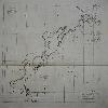
A chart of the North west Pacific Ocean showing the declinations of the compass from George Louis Leclerc Buffon's 'Histoire Naturelle, Generale et Particulaire' 1749-1804.
Stock number:7789.
|
|
Imprint: Paris, 1788
510 x 580 mm. light toning to centrefold, with folds as issued, on good thick paper.
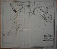
A chart of the Indian Ocean showing the declinations of the compass from George Louis Leclerc Buffon's 'Histoire Naturelle, Generale et Particulaire' 1749-04. This map appears in the Minereaux volume of 1788. It shows the waters from South Africa to Borneo including Arabia, Indian and South East Asia. The measurements are the work of La Perouse during his fateful voyage supplemented by those of the eminent scientist Jean-Charles Borda.
Stock number:7838.
|
|
|
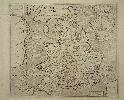
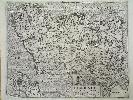
Imprint: London, R. Wilkinson, No. 58 Cornhill, 7 September 1786
735 x 525 mm., in fine early wash colour, cut and dissected, laid on contemporary linen, with original marbled paper slipcase in excellent condition, paper label with manuscript 'Derby' on one side, very good condition.
This is a reduction of a large-scale map drawn by Peter Perez Burdett (c.1734-93), a surveyor, mapmaker, draughtsman and engraver although he was not responsible for producing this plate. He began his career in Derbyshire before moving to Liverpool in 1771. It is not so well known that Burdett produced the first aquatint published in England and sold the process to Thomas Sandby. He was part of a circle of friends who met in Derby to discuss advances in the arts and sciences. Amongst the group was the artist Joseph Wright. Burdett produced just two large scale county maps, one of Derbyshire in 6 sheets c.1767 and one of Cheshire c. 1777.The Society for the Encouragement of the Arts launched an award of £100 for the best large-scale map in 1762. Out of a total of eleven applicants in the first years of the Societys initiative, only two were eventually judged to be worthy
Benjamin Donn, for his map of Devon, and Peter Burdett for his map of Derbyshire (Delano-Smith). Although the engraver of this map is not identified it seems probable that it was Thomas Kitchin.The map is published by Robert Wilkinson (1752?-1825) who took over the business of John Bowles following his death in 1779. Despite being a reduction the map accurately depicts an extensive road network with mileage markers recorded. An interesting aspect of the map is its early geological content. Beds of limestone and coal are recorded pricked and solid lines accordingly according to the notation upper right. Delano-Smith (1997) pp. 120-22; Delano-Smith & Kain (1999) pp. 94-5; ODNB; Rodger (1972) no. 78; not in Tooley 'Large Scale English County Maps and Plans of Cities not Printed in Atlases', Map Collector 27 pp. 36-8; Tooley (1999-2004); Worms & Baynton-Williams (2011).
Stock number:9888.
|
|
Imprint: London, Printed for John White at the holy lambe in Litle Brittaine near unto Aldersgate Street, [1622]
Edition: First Edition Quarto (280 x 195 mm.), full eighteenth century ornate blind panelled calf, gilt ruled, rebacked ribbed spine with gilt ruled compartments, preserving original gilt dragon emblazoned calf label, gilt title. (x) 320 (xii) pp. with Roman and Italic type with printed side notes. Errors of pagination as called for. With engraved frontispiece portrait laid down, beautifully engraved title page, large folding map inserted and 109 woodcut coats of arms in the text. An excellent example.
A very good example of the first edition of one of the earliest county histories and one of the best by the Leicestershire antiquary and topographer William Burton (1575-1645). He was the brother to the English scholar Robert Burton (1577-1640) best known as the author of 'The Anatomy of Melancholy'. This example bears instead of the usual William Kip map of the county a very rare one by WILLIAM SMITH with which this book has a SPECIAL CONNECTION. The work was originally written for Burton's private use but with the insistence of his patron George, Marquis of Buckingham, it was published. He began work on it in 1597 and had probably completed it by about 1604. If it is criticised for anything it is usually that too much was spent on recording various family genealogies. The plates however are highly rated. The portrait of Burton at the front aged 47 is by the great portrait engraver Francis Delaram. The beautifully engraved title page displays figures of Fame (winged) and Truth (naked), the left side bears a woman representing Leicestershire whilst on the right a woman representing 'Antiquitye'. At the bottom is a plan of Lindley, Burton's seat. The text consists of an alphabetical list of the towns and villages each followed by short descriptive text including details of notable buildings and families. Apart from the fact that this example is in particularly fine condition the most interesting feature is the inclusion of William Smith's map of Leicestershire and Rutland. The usual map is that of William Kip originally published in the 1607 edition of William Camden's 'Britannia'. The map is drawn from that of Christopher Saxton but as we are told on the third page of the address to the reader Burton provided 80 new place names for a map engraved by Jodocus Hondius in Amsterdam, "at the request of a friend of mine [such a shame he didn't name Smith here!] I rectified (certain yeres passed, Christopher Saxtons mappe of this Countie) with an addition of 80 townes, which was graven at Amsterdam by Jodocus Hondius 1602 and since imitated by M. Speed" (Burton). It was from this map that William Kip drew his. This is one of the few contemporary references to an incomplete series of English County maps which had been known popularly as those of the Anonymous mapmaker. Recent research identified them to be the work of William Smith. This superb example of the map was clearly inserted at a later date most likely commensurate with its publication by John Overton, c.1670. This is the third state of the map; the first two are of great rarity. Provenance: bookplate of The Right Honourable Washington Sewallis Earl Ferrers dated by hand 'Staunton Hants 1848'; Old Hall Bookshop; private English collection. Anderson (1881) p.164; Deadman & Brooks (2010) p. 20; ESTC S107138; Lowndes (1864) 330; STC (1986) 4179; Taylor (1968) II 1237; Upcott (1968) pp. 481-2.
Stock number:7280.
|
|
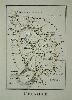
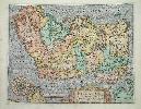
Imprint: London, 1804
120 x 90 mm., early outline colour. In good condition.
This charming map of Cheshire orientated with east at the top is from William Green's 'Picture of England' printed in 1804. It was first issued in Robert Butters' 'An Atlas of England' the previous year. Butters (fl. 1785-1808) was a printer in London and this is his only atlas work although he was involved in the 'Political Magazine'. The 'Picture of England' was published by John Hatchard (1769-1849), founder of the bookshop which still bears his name. Refer Carroll 58.
Stock number:4972.
|
|
|
Imprint: London, 1782-90
Binding: Hardback Inscription: Signed, Inscribed Or Annotated Quarto (280 x 195 mm.), recent half calf preserving original marbled paper boards, spine with raised bands, gilt ruled compartments each with ornate blind central feature. With 40 (of 41) engraved maps, including 3 general and the English counties, lacking Derby, the following with some trimming into the imprints; Cheshire, Cornwall, Essex, Hampshire, Leicester, Middlesex (in poor condition), with some traces of old folds, some light offsetting, otherwise in good condition.
There is ONLY KNOWN BOUND COLLECTION OF FIRST STATE MAPS. The Political Magazine began publishing in January 1780 at the hands of John Bew, bookseller and publisher of 29 Paternoster Row, London. From the beginning, Bew was keen to continue the tradition of eighteenth century Magazines of including maps. As an engraver, he employed John Lodge ((fl.1755-96) who had previously worked for the Gentlemans Magazine. In April 1782, a map of Ireland was published, one of Scotland in October 1784 and finally England and Wales in November 1785. John Murray (1737-93) joined Bew in partnership in February 1785 and from April of that year was in sole control. January 1787 saw the publication of Middlesex, followed by the Isle of Wight and Kent by May. By then a plan had clearly formulated to publish a full series of the county maps as from the following issue of June 1787 the county maps were issued in alphabetical order virtually monthly. In October 1789 Robert Butters (fl.1772-1809) of Fleet Street took control and continued the work with the publication of Oxford through completion in December 1790 with that of Yorkshire. It was to be the very last issue of the work.The county maps up to Northamptonshire with the sole excetpion of Nottingham are all in the very rare first state bearing reference to the Political Magazine and date of issue in the upper right corner. The name of Lodge as engraver appears lower right along with the publishers imprint below and a further date. The imprints on the maps reflect the change of ownership with the counties. The ensuing maps are all made up from the second state in which the imprints are removed. Traces of old folds on the earlier maps indicate this example is made up of magazine issues of the maps. The three general maps published some time before the counties were started are included. The atlas is very rare but is always found in a state where all imprints are removed from the plates. None of the known examples provide any publisher information, all lack a title page but one or two examples bear a title label affixed to the upper board reading Atlas of Great Britain and Ireland. There is no date although Fordham recorded an example with a watermark date of 1795 present.The references to Cluer Dicey in some carto-bibliographies refer to a copy of the last composite Henry Overton atlas held at Pembroke College, Cambridge. In this example, several of the Lodge plates are pasted in, which of course provides no further bibliographical information to us. It is unlikely to be John Lodge who was most likely employed to engrave the plates for the publishers and who died 1796. The most likely candidate for issuing the bound collections is Robert Butters. He was the final publisher of the Political Magazine and therefore the most likely owner of the plates at this point. Why though, were the imprints removed for the second issue?Provenance: the following all inscribed on first front free endpaper, 'Amelia Gillman from Grandma Gillman 1854', 'W. Gray family map book', Henry Gray, 32 Dean St. Soho West, London ', August 19 1877 Given to him by his affectionate father'. Carroll (1996) 51; Chubb (1927) 249; Harris, F. J. T. & Angel, J. L., A History of Paper Making in and Near Winchcombe, Gloucestershire, England, in Gloucestershire Society for Industrial Archaeology Journal for 1975 pages 9-65; Hodson (1984-97) p. 70; Jolly (1990) I pp. 145-72; refer Shirley (2004) T.Lod 1a (second edition); Worms & Baynton-Williams (2011).
Stock number:9395.
|
|
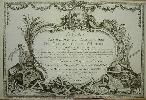
Imprint: Paris, 1790
320 x 470 mm., small wormhole at the bottom.
Title page to the 'Atlas Methodique et Elementaire' by Claude Buy de Mornas published in 1790. Shirley 'Atlases in the BL' T.Buy-1b.
Stock number:3460.
|
|
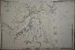
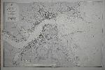
Imprint: London, Admiralty Office, 1849
Edition: First Edition 635 x 955 mm., with some light foxing, otherwise in good condition.
The first edition first state of E. Killwick Calver's survey of the entrance to the River Tyne featuring in great detail the city of Newcastle. The city is depicted before any bridges had been built but the Stanhope and Tyne Railway is depicted. The Newcastle and Tynemouth Railway is also illustrated. The Jarrow Slake in the south west is shown before the Tyne Dock's were built. On the north side of the Tyne the Northumberland Dock is similarly lacking.
Stock number:7742.
|
|
Imprint: London, Admiralty Office, 1849-[83]
635 x 955 mm., with some light offsetting, otherwise in good condition.
The E. Killwick Calver's survey of the entrance to the River Tyne with major corrections to 1883 featuring in great detail the city of Newcastle. The recently built Tyne Dock is shown to the south west built on the Jarrow Slake. The north side of the Tyne shows the Northumberland and Coble Dean Docks and neighbouring railways. The new Howdon Road runs north of this area. The other notable addition are the Channel works extending into the North Sea protecting the flow of traffic in and out of the river. This whole area is now dredged to a much greater depth.
Stock number:7743.
|
|
Imprint: London, 1753.
Edition: First Edition Binding: Hardback Folio (400 x 250 mm.), two volumes, full contemporary calf. Spine ribbed with 7 compartments, gilt lined, calf labels for title and volume. Volume 1; with engraved portrait of Camden by R. White, typographic title page within double rule border, 36 double page county maps by Robert Morden, 9 engraved plates. Volume 2; typographic title page within double ruled border, 15 double page county maps by Robert Morden. pp. (64), cclxvii, 696 (numbered columns, actually 348); (2), 829 (numbered columns paginated in continuation 697-1526); (176). With some light browning and occasional offsetting, generally a fine looking example.
Robert Morden is arguably best known for the series of maps he produced for the first edition of Dr. Edmund Gibsons translation of William Camdens 'Britannia'. Gibson (1669-1748) had first projected the work in 1692 when a Fellow of Queens College, Oxford. He turned to Morden (d.1703) to provide the maps. His sources are varied and are analysed by Skelton. The atlas was published in later editions in 1722, c.1730, 1753 and 1772. The availability of text leaves printed for the edition of 1722 had by now been exhausted and the book was out of print. This 1753 edition has had the text entirely reset word for word. The plates have been retouched in a number of instances and there are even some revisions made. During this time the ownership had changed too. Originally published by Awnsham Churchill it was in the hands of ten publishers in 1730 and the present 14 publishers by 1753. Hodson goes into great detail about the various changes of shareholdings. Records survive recording the print run as being 500 copies. A lovely example. Provenance: bookplates of Thomas Wright Esqr. of Santon Downham, Suffolk 1767 and Frank Cubitt; public auction. Beresiner pp. 157-60; Chubb 116; Hodson 171; Shirley BL T.Camd 5d; Skelton 117.
Stock number:1852.
|
|
|
Imprint: London, J. Nichols, for T. Payne & Son, G.G.J. & J. Robinson, 1789
Edition: First Edition Binding: Hardback Folio, three volumes (435 x 265 mm. each), full contemporary tree calf, ornate gilt panelled boards, spine with raised bands, extremely ornate gilt decorated compartments, ornate gilt calf title and volume labels to each, marbled endpapers, light wear. With frontispiece engraved portrait of William Camden in the first volume, typographic title pages to each volume, pp. viii, [2], xxii, [4], viii, cxlix [with cx*-cxv* inserted in sequence], [1, blank], 351, [1, blank], [36]; [6], 598 [with 161*-166* inserted in sequence], [42]; [6], 760, [54], with 154 engraved plates and maps, of these 97 are engraved plates of which 8 are double page and 57 are engraved maps, of which 52 are double page, all in early outline colour, further additional engraved illustrations within the text, includes a folding letterpress on the genealogy of Oliver Cromwell in volume 2, some foxing and offsetting as is often found in this work, extensive to Wiltshire, otherwise in good condition.
The first edition of Richard Gough's translation of William Camdenâs original classic work. Gough (1735-1809) was a noted antiquarian and collector and Director of the Society of Antiquaries from 1771-97. His collection survives today at the Bodleian Library in Oxford and it is considered one of the premier sources of British cartographic material. The âGoughâ map is its most noted possession. In 1768 he published Anecdotes of British Topography, followed by the considerably expanded British Topography in 1780, both highly important compendiums of British maps and topographical material known at the time. Sir John Cullum of Hardwick House wrote to Gough in 1782 stating that 'next to the Bible' his text was the work he most consulted. 'Map collectors at least should recognize British Topography as the first comprehensive inventory of British maps and associated topographical literature. There has not been a work of comparable scope in the 200 years since it was written and although it may be dated it has not been replaced' (Walters). Robert Mordenâs publication of William Camden's Britannia first issued in 1695 had last been issued in 1772 and a fresh translation from the original Latin text was deemed essential by Gough. The undertaking began in 1773 and it took him seven years to translate and assimilate his own research. âAs well as visiting every county himself, he called upon a network of antiquarian friends and correspondents to seek out information, check proofs, and offer suggestionsâ (ODNB).For a set of maps to illustrate the work he turned to the John Cary (1755-1835) who was having success with the New and Correct English Atlas of 1787. Cary did not rely on any one particular source and appears to have utilised many of the prior large-scale county maps which had been published. A proof copy is found in the Gough Collection at the Bodleian Library, the maps are marked with annotations in Goughâs own hand. Chubb (1927) 271; Fordham (1925) p. 30; ODNB; Shirley (2004) T.Camd 7a; Walters (1978) 'Richard Gough's Map Collecting for the 'British Topography'', in The Map Collector no. 2 pp. 26-8; Worms & Baynton-Williams (2011).
Stock number:10207.
|
|
|
Imprint: London, 1722
Edition: First Edition Binding: Hardback Folio, two volumes (380 x 240 mm. each), early half calf, marbled paper boards, ribbed spines, gilt ruled, gilt titles and volumes numbers, later endpapers watermarked 1804. Volume 1 with engraved portrait of Camden by R. White, typographic title printed in red and black within double ruled border to both volumes and 51 engraved maps including 3 engraved general maps, 42 double-page county maps and general maps of North and South Wales, North and South Scotland, Ireland and the Smaller Islands by Robert Morden, 9 engraved plates of coins, 4 engraved illustrations in the text, one full-page, pp. (66), cclxviii (double column numeration), (2), 696 (double column numeration); (2), 697-1526 (double column numeration), (175), Hampshire, Derby, Worcestershire and Stafford trimmed close, Surrey repaired tear lower right, Hertfordshire tight as usual, otherwise in good condition.
Robert Morden is arguably best known for the series of maps he produced for the first edition of Dr. Edmund Gibsonâs translation of William Camdenâs Britannia. Gibson (1669-1748) had first projected the work in 1692 when a Fellow of Queenâs College, Oxford. He turned to Morden (d.1703) to provide the maps. His sources are varied and are analysed by Skelton. This second edition of Edmund Gibsonâs version of William Camdenâs Britannia was some years in the making as evidenced by the Preface where he states that âabout twelve Years since, I turnâd my Thoughts in earnest, towards the farther Improvement and Perfecting of this Workâ. This included new information received from a variety of correspondents he goes on to name. It appears the delays were largely due to the pressure of his diocesan career. He became Bishop of Lincoln (1716-20) and of London (1720-48). The Churchill brothers Awnsham and John had become in the interim one of the most successful booksellers in London. Indeed, Awnsham having made his fortune bought an estate in Dorset and became M.P. for Dorchester 1705-10. John Churchill died in 1716 as indeed had Robert Morden in 1703. The third partner Abel Swale was out of business having fallen on desperate times. Despite closing his shop in 1719 and selling most of his stock to William Taylor it appears Churchill had retained the rights to the Britannia. For this edition, he arranged for Taylor to be the distributor. In answer to some of the original criticism about the accuracy of the maps, Churchill had all but eleven of the plates amended. Hodson in his remarkable bibliography, details some of the alterations to each plate. On the county map this was possibly due to there being no suitable correspondent to supply the necessary information. That of the smaller Islands was altered during the issue of this edition and provides a later variant. In this example, the map is in the earlier state. Of the original fifty plates two were replaced, that of North Wales is one. That of Scotland is replaced by two separate maps of North and South Scotland derived from that by John Senex published in the New General Atlas, 1721. The text underwent a large printing, enough to supply the following edition c.1730. Provenance: private English collection acquired after 2012. Carroll (1996) no. 19; Chubb (1927) 115; ESTC T144701; Hodson (1984-97) 169; Shirley (2004) T.Camb 5c.
Stock number:10141.
|
|
Imprint: London, 1607-[37]
270 x 320 mm., in good condition.
This map of England and Wales engraved by William Hole is derived from that of Gerard Mercator published in 1595. This is from the first fully illustrated edition of Camden's great work 'Britannia'. There were three editions in 1607, 1610 and 1637, this example being from the last. Shirley, R.W. (BI to 1650) no. 280; Skelton 5.
Stock number:6230.
|
|
Imprint: London, 1607-[10]
280 x 350 mm., with fine modern wash colour, in good condition.
This map of Ireland is derived from Baptista Boazio's map of Ireland dating from 1595 of which only a few examples survive. This is the first available printed map following the improved cartography from the first fully illustrated edition of Camden's great work 'Britannia'. There were three editions in 1607, 1610 and 1637, this example being from the second with no text on the verso. The map appears in only the one state. Bonar-Law p. 36-7; Skelton 5.
Stock number:4991.
|
|
Imprint: London, 1607-[10]
280 x 350 mm., in good condition.
This map of Ireland is derived from Baptista Boazio's map of Ireland dating from 1595 of which only a few examples survive. This is the first available printed map following the improved cartography from the first fully illustrated edition of Camden's great work 'Britannia'. There were three editions in 1607, 1610 and 1637, this example being from the second. It appears in only the one state. Bonar-Law p. 36-7; Skelton 5.
Stock number:4983.
|
|
Imprint: London, 1607-[37]
27 x 38 cms., light mark to lower margin and small split nearby, both short of the image
From the first fully illustrated edition of Camden's classic work, the 'Britannia'. An example of the second state from the third edition. Refer to Skelton no. 5
Stock number:3728.
|
|
|
Imprint: London, Richard Phillips, Bridge-Street, Blackfriars, 1808
Edition: First Edition Octavo, two volumes (215 x 130 mm. each), full contemporary mottled calf, gilt panelled, spines with gilt ruled compartments, each with gilt central feature, red and blue calf gilt title and volume numbers, marbled endpapers. With typographic title page, pp. xiv, (2), unpaginated signatures B8-Ll2; Ll3-3X2, with 46 engraved maps comprising general map of the British Isles (folding), 40 single sheet English county maps, Wales (folding) and 2 sheet maps of Ireland and Scotland, all folding, all in fine early wash colour, some light spotting to text at the beginning of volume one, otherwise in good condition.
FIRST EDITION. Benjamin Pitts Capper produced just this one work but it proved to be a successful one. It was first published by Richard Phillips (1767-1840) in 1808. Capper worked in the Secretary of States office. The Introduction states that the compiler having assisted in preparing the abstracts of the answer and returns made to the Population Act, as well as in arranging the returns of the Cultivation of the Kingdom, which were laid before Parliament, in 1802, he has been enabled to correct in this Work every error which appeared in the account printed for the Parliament.Phillips was born in London to a Leicestershire family. He founded the Leicester Herald in 1792. He was sentenced to 18 months in gaol for selling Thomas Paine's 'Rights of Man' the following year. In 1795 his premised burnt to the ground and with the insurance money he returned to London where he founded 'The Antiquarians' Magazine and Monthly Magazine'. He became Sheriff of London and Middlesex in 1807 and was knighted in 1808.To accompany the work, Phillips employed Henry Cooper (fl.1804-19) to engrave a series of plates. They are loosely drawn on those of Cary. Wales is described in the list of maps as consisting of two plates when in fact it is just one. The title page announces the work is available Price 24s. complete in boards although the work can be acquired without maps for 18s. Similarly, the maps may be bound alone for 9s. or with colour for 12s. and entitled Atlas of the British Islands, a very rare work. Phillips was bankrupted in 1811 and sold the rights in the book to the new publishers Longman, Hurst, Rees and Co. Provenance: private English collection. Carroll (1996) no. 64; Chubb (1927) 327; Worms & Baynton-Williams (2011).
Stock number:9937.
|
|
|
Imprint: Philadelphia, Mathew Carey, No. 121, Chesnut Street, 1814
Duodecimo (180 x 110 mm.), full contemporary marbled calf, gilt ruled compartments to spine, red calf gilt title label affixed. With typographic title page, pp. iv, 168, with 23 (20 listed) maps & 2 folding tables, in good condition.
Following the American Revolution there was a burgeoning domestic production of cartography. Up to this point the market had been dominated by British published material with very little locally produced. One of the first American pioneers in this new market was Matthew Carey (1760-1839). Born in Dublin, Ireland, he was dropped at just a year old by his nurse and sustained lifelong injuries as a result. Possibly therefore he became a shy child and hid himself in books. From an early age he wanted to be a book printer and publisher. He wrote his first piece, against duelling, when he was 17 years old. He wrote a tract anonymously in support of the Catholics which brought about a reward of £40 for his arrest by a conservative group. He left for Paris where he was introduced to Benjamin Franklin. He worked with Franklin at his press in Passy before returning to Ireland where he set up a newspaper. Within a year, he had incurred the wrath of the government and was committed to Newgate Prison for a short while. With a new prosecution impending he fled following his release for America on 7 September 1784 by dressing as a woman. He arrived in Philadelphia with just 12 guineas to his name. He received a summons from General Lafayette who gave him $400. On 25 January 1785, he published the first issue of the Pennsylvania Herald which supported the conservative party. It proved to be a success. However, it drew him in to a bitter dispute ending in a duel with Colonel Oswald, the editor of the Independent Gazetteer in January 1786 which left him badly wounded. In the thigh. He was one of the founders of the Columbia Magazine and then published the American Museum.Geographical texts were being published in the newly formed United States, the first was by Jedidiah Morse whose American Geography in 1789 contained 2 maps. This was followed by Benjamin Workmans Elements of Geography with 3 maps. Collections of sea charts were available by Matthew Clark in 1790 and John Norman in 1791. The idea of a small America atlas or gazetteer was first demonstrated by Joseph Scott in 1795[94]. Carey prepared his own American Pocket Atlas the following year. Issued with 19 maps of the United States there was a second edition in 1801. The edition of 1805 was expanded with a map to illustrate the Louisiana Purchase of 1803. In this 1814 edition three further new maps were introduced; those of the Upper Territories, Mississippi Territory and Missouri Territory. The latter incorporates information from the Lewis & Clark expedition (Schwartz). There does exist in the Library of Congress an extremely rare 1813 edition which may have suffered during the War of 1812. It contains the same maps, but only one other example could be traced at auction in the last 40 years, lacking all maps. The folding tables at the end include population statistics from the Census of 1810 and Export figures for each state.A good example with a fine frontier provenance. In 1818 Louisville was growing rapidly, within 10 years it would have a population of 7,000. It is interesting to see from the text that even in 1810 Kentucky had 2,000 distilleries! Provenance: with manuscript notation at the back of Paul Jaminiere, Louisville Kentucky 5 December 1818; Andrew Cumming, January 2000; Burden collection. Howes C137; Phillips 1372 & 4523; Ristow 151; Sabin 10856; Schwartz & Ehrenberg (1980) p. 231.
Stock number:9897.
|
|