|
|
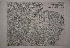
Imprint: London, 1644-[88]
390 x 520 mm., early outline colour, with good sized margins, upper left corner reinstated, otherwise in good condition.
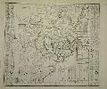
This map is part of the great Quartermasters Map. It is known as this because of the general title referring to its usefulness to all Comanders for Quarteringe of Souldiers, & all sorts of Persons, that would be informed, Where the Armies be; never so Commodiously drawne before this. 1644. It was as stated used widely during the English Civil War, particularly by the Parliamentarians with whom the publisher Thomas Jenners sympathies lay. Jenner (fl. c.1618-73, d.1673) was a print and mapseller who set up in business at the White Bear in Cornhill about 1618. Until the impending Civil War Jenner was not known for cartographic material. Then in 1643 he published a revised edition of the 'Direction for the English Traviller' whose plates he had acquired from his printer Matthew Simmons. Jenner had timed his move perfectly. Demand for maps and tools to help the large numbers of people moving about the country at the time of the Civil War was on the increase. The market for the little atlas clearly proved so great that he was attracted to do more. He engaged the services of the noted engraver Wenceslaus Hollar to etch a reduction of Christopher Saxtons great wall map of 1583. This would enable his customers to have a more detailed and yet still portable map of England and Wales.Hollar (1607-77) is described by Pennington in glowing terms: Of all etchers, Hollar is certainly the most varied in subject, one of the most accomplished in technique, and with a style that is full of a charm, a humour, and a good nature that are evidently the character of the man himself. He was born in Prague and made his way to England in the party of Lord Arundel arriving in London in late December 1636. By 1644 Hollar had already done some work for Jenner which included working on at least two of the re-engraved plates for the 'Direction for the English Traviller' published in 1643. The published history of the Quartermasters Map is long and complicated extending to 1824. Its earliest form is that which bears the date 1644 on the title. The plates were then acquired by John Garrett who issued the third edition in 1675. It was revised almost immediately in to a fourth edition the following year. In 1688 single line roads were added to those double-lined which had only just been introduced. It is this edition from which this plate comes. It is the fourth state of this particular plate which covers East Anglia and much of the midlands. Harley & Skelton (1972); Pennington (1982) 652-7; Shirley (1980) no. 537; Wing H2447.
Stock number:8956.
|
|
Imprint: London, E. Cave, at St. John's Gate, 1753
Inscription: Signed, Inscribed Or Annotated Octavo (210 x 135 mm.), full contemporary calf, gilt ruled, raised bands with very ornate gilt compartments and gilt title label. [2], ii, [296], 4 pp. including 4 front & final blank endpapers, in good condition.
This very rare work is an index to the first twenty volumes of the Gentleman's Magazine. It was published by Edward Cave who gave the then struggling SAMUEL JOHNSON (1709-84) his first major break. Johnson was a regular contributor particularly of political material. Indeed at a time when the reporting of the proceedings of the Houses of Parliament was banned he found a way around it. He called the reports "Debates of the Senate of Magna Lilliputia". They were allegedly written by the hand of Lemuel Gulliver's grandson. These accounts began in June 1738 following the House of Commons resolution banning reporting of proceedings and ran to 1745. Although the words were his own they were an accurate representation of the participants. They cover Robert Walpole's rise and the period leading up to the War of Jenkins's Ear in North America. 'Columbia', the poetic name for America first coined and used by Johnson in the Magazine in 1738. It has its own entry in the Index. "Johnson and his collaborators evolved a complex code to record the debates, mixing allegorical byplay in the manner of Swift with studied Ciceronian oratory: speeches were put into the mouths of characters whose names transparently revealed their real identity (as Walelop or Ptit)" (ODNB). Indeed they are held in such high regard that they are taken as an accurate record of the proceedings. This work was published two years before Johnson seminal 'Dictionary of the English Language' and it is most likely he had a hand in its construction. The Preface is written by Johnson and the contents include a list of his own contributions. The final four pages of advertisements are here placed at the end of the work. Bookplate of Sir Charles Henry Frankland (1716-68)- of Great Thirkleby Hall, Thirsk, to front pastedown, contemporary ownership signature to verso of front blank. Provenance: bookplate of Frankland. ESTC N30705; Fleeman, J.D. Johnson, 53.2GM/1.
Stock number:7818.
|
|
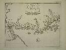
Imprint: Manchester, Thos. Johnson, 1847
Binding: Hardback Quarto (280 x 215 mm.), full contemporary green cloth binding, blind tooled panels with ornate blind corner decoration, gilt vignette and title to upper board, gilt title to spine dated 1849, light wear. With title page, contents leaf and 42 full fresh early wash coloured maps, each interleaved, last half dozen leaves with water damage to upper edge, otherwise in good condition.
The plates for this VERY RARE atlas are by Joshua Archer (1792?-1863) and were first published in William Pinnocks Guide to Knowledge, 1833. Archer was declared bankrupt shortly after in 1835 and was in prison for debt again in 1845. What is unusual about the plates for this period is that they were produced using woodblocks and printed directly resulting in a map which is white on black. The process of lithographic transfer was used for Thomas Johnsons atlas offered here. This preserves the original block or plate from excessive wear and allows an extended life. A Thomas Johnson is recorded as being a bookseller, stationer, bookbinder, printer and publisher in Liverpool between 1833-43. This is possibly the same Johnson as our publisher after a move to Manchester. For this atlas, the existence of some of the early railways is recorded. One further edition appeared in 1863 surviving in just two known examples. Provenance: manuscript annotation on front endpaper 'Stephen James Adams 1850'; private English collection. Carroll (1996) no. 98; Chubb (1927) no. 523; Worms & Baynton-Williams (2011).
Stock number:9247.
|
|
|
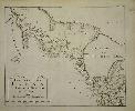
Imprint: Manchester, Thos. Johnson, 1847
Binding: Hardback Quarto (280 x 215 mm.), recent full cloth binding, preserving original cover gilt title label, gilt titles to the spine. With title page, contents leaf and 42 full early wash coloured maps, each interleaved, with some minor foxing as usual, otherwise in good condition.
The plates for this VERY RARE atlas are by Joshua Archer (1792?-1863) and were first published in William Pinnocks Guide to Knowledge, 1833. Archer was declared bankrupt shortly after in 1835 and was in prison for debt again in 1845. What is unusual about the plates for this period is that they were produced using woodblocks and printed directly, resulting in a map which is white on black. The process of lithographic transfer was used for Thomas Johnsons atlas offered here. This preserves the original block or plate from excessive wear and allows an extended life. A Thomas Johnson is recorded as being a bookseller, stationer, bookbinder, printer and publisher in Liverpool between 1833-43. This is possibly the same Johnson as our publisher after a move to Manchester. For this atlas, the existence of some of the early railways is recorded. One further edition appeared in 1863 surviving in just two known examples. Provenance: private English collection. Carroll (1996) no. 98; Chubb (1927) no. 523; Worms & Baynton-Williams (2011).
Stock number:9801.
|
|
|
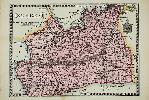
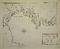
Imprint: Manchester, 1847
Binding: Hardback Quarto (275 x 215 mm.), full contemporary cloth binding, ornate blind panelling, central gilt title set within gilt vignette, partially rebacked retaining original spine with gilt title dated 1849, light wear. With lithographic title page, contents leaf and 42 full bold early wash coloured maps, interleaved, in good condition.
The plates for this VERY RARE atlas are by Joshua Archer (1792?-1863) and were first published in William Pinnockâs Guide to Knowledge, 1833. What is unusual about them for this period is that they were produced using woodblocks. The maps were the work of Joshua Archer (1792?-1863) and Selena Hall (fl.1831-53, the widow of the engraver Sidney Hall). Archer was declared bankrupt shortly after in 1835 and was in prison for debt again in 1845. Here the process used by Thomas Johnson for the Atlas of England, published in Manchester in 1847, is a lithographic transfer. A Thomas Johnson is recorded as being a bookseller, stationer, bookbinder, printer and publisher in Liverpool between 1833-43. This is possibly the same Johnson as our publisher after a move to Manchester. Lithography preserves the original block or plate from excessive wear and allows an extended life. For this atlas the existence of some of the early railways is recorded. One further edition appeared in 1863 surviving in just two known examples. Provenance: William and Victoria Dailey, Los Angeles; Bernard Quaritch Ltd (pencil collation inscription on final free endpaper, 1984); private English collection; Clive A. Burden Ltd. Catalogue V (2010) item 43; private English collection. Carroll (1996) no. 98; Chubb (1927) no. 523; Worms & Baynton-Williams (2011).
Stock number:10292.
|
|
|
Imprint: Manchester, 1863
Binding: Hardback Quarto (265 x 210 mm.), contemporary half calf, cloth boards, blind embossed title and globe on upper board, rebacked retaining original spine, blind ruled compartments and blind title, light wear. With lithographic title page and 42 full bold early wash coloured maps, interleaved, in good condition.
ONE OF ONLY TWO KNOWN EXAMPLES. The plates for this VERY RARE atlas are by Joshua Archer (1792?-1863) and were first published in William Pinnockâs Guide to Knowledge, 1833. What is unusual about them for this period is that they were produced using woodblocks. The maps were the work of Joshua Archer (1792?-1863) and Selena Hall (fl.1831-53, the widow of the engraver Sidney Hall). Archer was declared bankrupt shortly after in 1835 and was in prison for debt again in 1845. Here the process used by Thomas Johnson for the Atlas of England, published in Manchester in 1847, is a lithographic transfer. A Thomas Johnson is recorded as being a bookseller, stationer, bookbinder, printer and publisher in Liverpool between 1833-43. This is possibly the same Johnson as our publisher after a move to Manchester. Lithography preserves the original block or plate from excessive wear and allows an extended life. For this atlas the existence of some of the early railways is recorded. This is an example of the one further edition which appeared in 1863. It survives in just one other known example. The same lithographic title is used although the date is applied typographically. One item omitted in this edition is the contents leaf, it is not present in either example. Carroll (1996) no. 98; Chubb (1927) no. 523; Worms & Baynton-Williams (2011).
Stock number:10293.
|
|
Imprint: Manchester, 1863
165 x 230 mm., early wash colour, light brown stain to lower margin, otherwise in good condition.
The map for this VERY RARE edition is by Joshua Archer (1792?-1863) and was first published in William Pinnocks Guide to Knowledge, 1833. Archer was declared bankrupt shortly after in 1835 and was in prison for debt again in 1845. What is unusual about the plates for this period is that they were produced using woodblocks and printed directly resulting in a map which is white on black. The process of lithographic transfer was used by Thomas Johnson for the map offered here. This preserves the original block or plate from excessive wear and allows an extended life. A Thomas Johnson is recorded as being a bookseller, stationer, bookbinder, printer and publisher in Liverpool between 1833-43. This is possibly the same Johnson as our publisher after a move to Manchester. The existence of some of the early railways is recorded. One further edition appeared in 1863 surviving in just two known examples. It is from this extremely rare last edition that this plate derives. Carroll (1996) no. 98; Chubb (1927) no. 523; Worms & Baynton-Williams (2011).
Stock number:9330.
|
|
Imprint: Edinburgh & London, 1848
Edition: First Edition Binding: Hardback Imperial folio (560 x 360 mm.), later half calf, green cloth boards, gilt ruled, rebacked preserving original spine, raised bands to the spine with gilt and blind ruled compartments, gilt title, marbled endpapers. With engraved title, Dedication to Baron Alexander von Humboldt, Preface, Contents and Index, with 30 engraved maps with early outline and wash colour, in very good condition.
THE FIRST EDITION OF THE FIRST BRITISH ATLAS ON PHYSICAL GEOGRAPHY. The successful firm of W. & A. K. Johnston was founded by Sir William Johnston (1802-88) and was based in Edinburgh from 1825. The following year he was joined by his brother Alexander Keith Johnston (1804-74). The 'Physical Atlas' offered here is the 'first British atlas to give a synoptic view of physical geography' (Tooley). It is arranged in four distinct sections: Meteorology including 5 maps, Hydrology with 6 maps, Geology with 10 maps and Phytology and Zoology with 9 maps. Each section is accompanied by descriptive text. In 1842 Johnston visited Europe and met Doctor Heinrich Carl Wilhelm Berghaus (1797-1884) who was an engineer and geographer from Cleve, now in Germany. After his studies Berghaus worked in the Prussian Land Survey Office and then became a teacher of geodesy and a pioneer in the field of scientific and thematic cartography. He worked closely with the publisher Justus Perthes, who published the first edition of the Physikalischer Atlas in 1836. As the title to the 'Physical Atlas' states this work is based on Berghaus' 'Physikalischer Atlas'. Dreyer-Eimbcke, Oswald (1997) Heinrich Berghaus and August Petermann in IMCoS Journal 70 pp. 19-27; Shirley (2000) 'Berghaus and Johnston: Pioneers of the Thematic Atlas', in IMCoS Journal no. 83 pp. 31-5; Smith, D. (2000) 'The Business of 'W. & A. K. Johnston' 1826-1901', in IMCoS Journal 82 pp. 9-19; Smith, David. (2001). 'The Cartography of 'W. & A. K. Johnston' 1826-1901', in IMCoS Journal no. 86 pp. 5-16; Worms & Baynton-Williams (2011).
Stock number:9275.
|
|
|
Imprint: Edinburgh, W. & A. K. Johnston, 1882
Binding: Hardback Folio (510 x 35 mm), contemporary half calf, red cloth boards, gilt ruled, with gilt title on upper board, rebacked with gilt ruled compartments, each with central gilt feature, gilt title, light wear at corners repaired, marbled endpapers. With half title, full title printed in black and red, Preface, Contents, pp. (8), 75, (7), with 45 maps of England and Wales, Scotland and Ireland, those of England Wales being double page, all in original wash colour, otherwise in good condition.
The successful firm of W. & A. K. Johnston was founded by Sir William Johnston and was based in Edinburgh from 1825. The following year he was joined by his brother Alexander Keith Johnston. This fascinating atlas provides statistics about the Educational Condition of the People, Industrial Condition, Criminal Condition, Pauper Condition, Military and Naval etc. Shirley (2000) 'Berghaus and Johnston: Pioneers of the Thematic Atlas', in IMCoS Journal no. 83 pp. 31-5; Smith (2000); Smith (2001).
Stock number:10331.
|
|
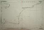
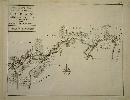
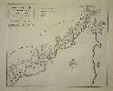
Imprint: Paris, 1822
625 x 950 mm. Very slight offsetting upper right.
This detailed chart of the Kent coastline was surveyed by Capt. Johnstone and M. Tapper according to the title. It extends from Dover westwards to Winchelsea, Sussex.The Depot des Cartes et Plans de la Marine was the government hydrographic service of France. It was founded in 1720 to provide the French Navy with accurate charts and was headed first by Jacques Nicolas Bellin. Tooleys Dictionary.
Stock number:2709.
|
|
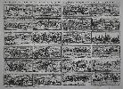
Imprint: Paris, A lenfent Jesus, c.1690
360 x 485 mm., with old folds after being bound in a book, some very minor restoration to folds but otherwise in very good condition.
Francois Gerard Jollain (1660-c.1735) was an engraver and printseller in Paris. He was part of a family of engravers, map and printsellers. He was the son of Gerard Jollain (d.1683). Beneath the title of this rare work is written 'par Gaspard Powell ingenieur dans larmee du Roy dangleterre et mis au jour en 1689'. This type of print whereby rows of topographical images are displayed is extremely rare but not unknown at the time. Peter Stent's Catalogue of 1653 refers to 'All the Cities of England in small'. It is only known by one example of a second state by John Overton which is bound into another work at the Ashmolean Library, Oxford. These complemented the fashion at the time for 'carte et figures', or maps with decorative illustrated borders.The title here alludes to the artist, one Gaspard Powell, and engineer in the Royal army in 1689. The claim is that he drew all the images on location himself. Two rows each are devoted to images of England, Scotland and Ireland. Tooley's Dictionary records the existence of a 'Carte des Isles Britanniques' by the same Jollain issued in the same year. There is only one recorded example of the map. Its dimensions are not dissimilar and it does not bear any surrounding views. It could be seen that the two plates were complimentary. The general map states that it was the work of 'L. de Pontigny', geographer to the King. It is interestingly dedicated to the Prince of Wales who would later become known as the Old Pretender in the first Jacobite Rebellion of 1715. It was his birth on 10 June 1688 which largely triggered the Glorious Revolution which overthrew James II in favour of the Protestant William III. They were no doubt issued to mark the attempt invasion of James II of Ireland Ireland from France. Francois Jollain (1641-1704), who is likely in some way related, also published a general map of the British Isles in the same year 1689. This one does contain several town views, all unrelated, and is similarly extremely rare, surviving in just three known examples. Provenance: private English collection since c.1990. Globe p.229 & no. 361-2; Griffiths (1998) p. 191; Tooley's Dictionary (1999-2004).
Stock number:7652.
|
|
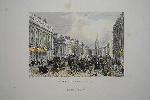
Imprint: London, Mary Read & Co., c.1855
195 x 230 mm., early coloured steel engravings, good margins, light foxing in the margins, otherwise in good condition.
One of the more desirable plates from Mary Read's 'Mighty London' published in parts from 1851-55. Usually published uncoloured, as Adams states "colour has been added to the steel engravings and lithotints in rare instances only". Adams no. 213 no. 14.
Stock number:7734.
|
|
|
Imprint: Paris, Louis Billaine, dans la Grand' Salle du Palais, au second Pillier, au grand Cesar, 1674
Quarto (240 x 175 mm.), full contemporary calf, blind panelled, with extremely ornate ribbed spine, each compartment with gilt decorative panels and central floral feature, red calf gilt title label affixed, marbled endpapers. With typographic title page, pp. (16), 262, 35, (1), 23, (7), 49, (2), 81, with 5 folding maps, 9 plates of which 3 are folding, with light waterstain to lower gutter near the beginning, otherwise in good condition.
The Recueil de Divers Voyages is a compilation of travel works translated by Henri Justel (1620-93). A rare work it comprised accounts not seen in print before with translations of five key English ones. A French Protestant, scholar and book collector, Justel was the secretary to Louis XIV. He left France for England in 1681 before the revocation of the Edict of Nantes in 1685. He was given the position of Keeper of the Kings Library at St. Jamess Palace by Charles II. The book includes accounts of Africa and America and the order in which these are found often varies. The following is a list of those included, each with its own half title:1 - Richard Ligon, 'Histoire de l'isle des Barbades', first published 1657.2 - Baltasar Telles, 'Extrait de l'histoire d'Ethiopie', first published in Lisbon in 1660Jeromyno Lobo, 'Relation de la riviere du Nil', first published 1669.3 - Antonio d'Almeyda, 'Description de l'Empire du Prete-Jean', 4 - 'Relation du voyage fait sur les costes d'Afrique aux mois de Novembre & Decembre de l'année 1670. Janvier & Février 1671. commençant au Cap Verd'.5 - De la Borde, 'Relation de l'origine, moeurs, coustumes religion, guerres et voyages des Caraibes, sauvages des isles Antilles de l'Amerique faite par le sieur De la Borde'.6 - 'Relation de la Guiane'.7 - Richard BLOME, Description de l'isle de la Jamaique' first published in London, 1672.8 - 'Relation de l'isle des Barbades'.9 - 'Colonies Angloises'.Of these accounts of de la Borde in the Caribbean and Guaine are published for the first time. There is a translation of Richard Ligons Barbados first published in 1657. Settled by the English in 1625 it exploded with 44,000 settlers by 1650, nearly four times that in Virginia and twice that of New England. The account includes a fine folding map of the island with large inset of the south east and the Caribbean engraved by Michault. Richard Blomes Description of the Island of Jamaica first published around Easter 1673, is also present. To illustrate it he included a map that is drawn directly from the first state of the Blome and engraved by René Michault who is known to have worked for Pierre Duval and Nicolas Sanson. The only difference being the addition of a few French translations of English nomenclature (Burden). The island is depicted just 18 years before the disastrous earthquake at Port Royal in 1692 which destroyed the town. The English work was supported by the Governor of Jamaica and Thomas Modyford, owner of large amounts of land on the island.The final section with the half title Colonies Angloises includes a fine map of the English colonies in North America stretching from Cape Henry in the south to Port Royal in Nova Scotia. To illustrate it he included a map that is drawn directly from the first state of the Blome and engraved by René Michault. The only difference being the addition of a few French translations of English nomenclature
There was a second edition published by the widow of A. Cellier in 1684. It, too, contained this map in an identical state. Provenance: Le Bail-Weissert, May 2001; private English collection. Atabey 527; Baer (1949) nos. 78 & 111; Blackmer 750; Burden (2007) nos. 439 & 440; McCorkle (2001) no. 674.1; The A. E. Nordenskiöld Collection no. 642; Sabin (1868) 36944.
Stock number:9892.
|
|
Imprint: Amsterdam, c.1730
340 x 390 mm., one small margin tear just in to the image, repaired.
Engelbert Kaempfer's 'History of Japan' was originally written in German. Kaempfer was a physician in Japan at the Dutch post of Dejima between the years 1690 and 1692. Shirley BL G.Kaem 1a.
Stock number:4041.
|
|
Imprint: Amsterdam, c.1730
310 x 460 mm., 2 brown small marks and small thinning of paper bottom off centre.
Engelbert Kaempfer's 'History of Japan' was originally written in German. Kaempfer was a physician in Japan at the Dutch post of Dejima between the years 1690 and 1692. Shirley BL G.Kaem 1a.
Stock number:4037.
|
|
Imprint: Amsterdam, c.1730
295 x 370 mm. Good condition.
Engelbert Kaempfer's 'History of Japan' was originally written in German. Kaempfer was a physician in Japan at the Dutch post of Dejima between the years 1690 and 1692. Shirley BL G.Kaem 1a.
Stock number:4038.
|
|
Imprint: Amsterdam, c.1730
305 x 375 mm. Good condition.
Engelbert Kaempfer's 'History of Japan' was originally written in German. Kaempfer was a physician in Japan at the Dutch post of Dejima between the years 1690 and 1692. Shirley BL G.Kaem 1a.
Stock number:4039.
|
|
Imprint: Amsterdam, c.1730
310 x 380 mm., in fine condition.
Engelbert Kaempfer's 'History of Japan' was originally written in German. Kaempfer was a physician in Japan at the Dutch post of Dejima between the years 1690 and 1692. Shirley BL G.Kaem 1a.
Stock number:4042.
|
|
Imprint: Amsterdam, c.1730
305 x 370 mm., in fine condition.
Engelbert Kaempfer's 'History of Japan' was originally written in German. Kaempfer was a physician in Japan at the Dutch post of Dejima between the years 1690 and 1692. Shirley BL G.Kaem 1a.
Stock number:4043.
|
|
Imprint: Amsterdam, c.1730
305 x 380 mm., in fine condition.
Engelbert Kaempfer's 'History of Japan' was originally written in German. Kaempfer was a physician in Japan at the Dutch post of Dejima between the years 1690 and 1692. Shirley BL G.Kaem 1a.
Stock number:4044.
|
|