|
|
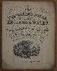
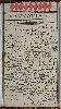
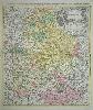
Imprint: London, c.1881
Small quarto (240 x 195 mm.), original paper wrappers with title. With 45 lithographic maps back to back, including a large folding map of England and Wales. Light wear, generally in good condition.
This series of plates was first published by John Teesdale as the rare New Travelling Atlas in 1830. An even rarer edition of 1843 ensued. Lithographed derivatives were published by John Heywood from 1860. This example can be dated to c.1881 according to the railways depicted and each bears population figures derived from the 1871 census. Provenance: Dr. Adrian Almond collection. Carroll (1996) 92.K; Not in Chubb.
Stock number:7502.
|
|
|
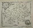
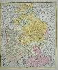
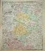
Imprint: Manchester, John Heywood, 141 & 143, Deansgate, c.1868
Binding: Hardback Small quarto (225 x 175 mm.), original paper wrappers with title and contents on upper cover, adverts on the back cover, cloth tape spine, advertisement of Heywood printed inside upper cover, waterstain to lower spine. With lithographic title page, folding map of England and Wales, regional maps of South and North Wales and 42 county maps, general map folding with old binder's tear repaired, otherwise in good condition.
Henry Teesdale (1776-1855) was a successful publisher in London is best known for two English County atlases. In 1829, he acquired the county plates to Robert Roweâs exceedingly rare English Atlas and after revision published them as the New British Atlas. Encouraged by its undoubted success he embarked on a reduced sized county atlas which he published the following year entitled A New Travelling Atlas. In this work, the roads are made the principal feature. For some reason, it was not a great success, at least judging from the fact that only five known examples survive. For the second edition in 1843 plate numbers were added as were railways in the counties where they had been introduced. Both series of copper plates became the property of Henry George Collins (fl.1832-58) and the Travelling Atlas was re-issued with his imprint about 1849. By 1857 the business had failed and ownership of the atlas had passed to William Somerville Orr, whose one edition is given the date of c.1852 although possibly later. Then they passed in to the hands of John Heywood who would issue a number of editions. This issue dates from 1868 which is generally accepted based on the state of the railway network depicted. Provenance: Doreen Green Collection; Clive A. Burden Ltd Catalogue XIV (2017) item 39; private English collection. Burgess (2004) no. 124; Carroll (1996) no. 92; refer Chubb (1927) no. 531; Tooley's Dictionary (1999-2004); Worms & Baynton-Williams (2011).
Stock number:10274.
|
|
Imprint: London, 1751
19 x 20.5 cms., with original folds as issued. Mild paper crease, otherwise good condition
The Universal Magazine of Knowledge and Pleasure was issued from 1747 to 1799. The founder John Hinton was a bookseller with a number of cartographic interests including the Large English Atlas. Publication of the Universal Magazine began in July 1747 and from the start included maps. There were many magazines issued during the eighteenth century, a lot included maps but only three contained a series of county maps - the London Magazine, 1747-60, the Political Magazine, 1782-90, and this one. All are rare. Three different engravers were employed by Hinton, Thomas Kitchin provided the first four maps until being poached by the rival London Magazine, his father-in-law Emanuel Bowen from then until that of Suffolk issued in 1759, then finally R. W. Seale. Hodson 38; Skelton - Hodson 253
Stock number:3510.
|
|
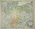
Imprint: London, J. & C. Walker., 1843.
Four sheets in all 129 x 163 cm., uncoloured. With some marginal repairs otherwise in fine condition.
This is a reduction in four large sheets of Greenwood's nine sheet map of 1828. This is the second state according to Rodger issued in the same year. The first bears the date July 1843, this the second bears September 1843 and the publishers address is added. There were four further editions to some time after 1847. Rodger 531.
Stock number:3835.
|
|
|
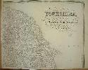
Imprint: London, 9 Castle Street Holborn, 1843
Binding: Hardback 1255 x 1585 mm., four sheets dissected and laid on contemporary linen in two halves, in early wash colour, with endpapers, laid into folio book, full cloth with ornate blind and gilt decoration to the boards, gilt title to upper cover, rebacked preserving original spine with ornate gilt title, with original metal clasp in working order, some light foxing, otherwise in good condition.
This large-scale map of Yorkshire is published by William Colling Hobson (d.c.1878). Amongst his works are several engraved by J. & C. Walker including this. The most recognisable is probably 'Walker's Fox Hunting Atlas'. The Walkers were part of an extensive family, many of whom were in the map business. John Walker (fl.1813-73) was a brother to Charles Walker (1799?-1872) and in about 1827 they formed the partnership of J. & C. Walker. The map is considered a reduction of the Christopher Greenwood's extremely large 9 sheet map in its second edition of 1828 by Henry Teesdale. This map was first published in 1843, this is an example of the third edition according to Rodger. There were two in 1843, the first bears the date July 1843, the second September 1843 and a publisher's address is added. Three further editions were to appear. The railways are here coloured in red. Rodger 532; Tooley's Dictionary (1999-2004); Worms & Baynton-Williams (2011).
Stock number:9855.
|
|
|
Imprint: London, Thos. Malby and Son, at the Globe Manufactory Parker Street, Little Queen Street, Lincoln's Inn Fields, 1839
Edition: First Edition 790 x 1010 mm., dissected laid on contemporary linen, in full early wash colour, marbled endpapers, with light soiling, publisher's burgundy calf slipcase with ornate blind panelling and gilt title, light wear, in good condition.
FIRST EDITION. We know little about William Colling Hobson who died c.1878. Amongst his works are several engraved by John & Charles Walker including this. The most recognisable of their collaborations is probably 'Walker's Fox Hunting Atlas'. The Walker's were part of an extensive family, many of whom were in the map business. John Walker (fl.1813-73) was a brother to Charles Walker (1799?-1872) and in about 1827 they formed the partnership of J. & C. Walker.This large-scale map of Durham is drawn at the scale of three quarters of an inch to a mile. It was first published here c.1839. Two ensuing issues were published in 1840 both dated. There are only three earlier large-scale printed maps of the county; the exceedingly rare Christopher Maire of 1711, Andrew Armstrong in 1768 and Christopher Greenwoods in 1820. This map was published by Thomas Malby (1781-1854) who were largely globemakers and chart publishers for the Admiralty. The map details all of the railways and tram ways. A rare map in its first state. Rodger (1972) 105; Tooley (1986) refer no. DV18; Worms & Baynton-Williams (2011).
Stock number:9972.
|
|
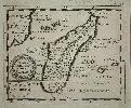
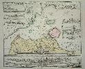
Imprint: London, c.1827
90 x 60 mm., in full early wash colour, in good condition.
EXTREMELY RARE. The origin of this series of copper plate county maps was until 1983 unknown. Joseph Allen was a publisher and engraver of 3 Hampden Str., Sommerstown, London. When originally uncovered, Yasha Beresiner identified the author as John Allen. It was in 1993 that Eugene Burden reported in private correspondence that he looked up the 1811 Directory and identified him as Joseph Allen (fl.1798-1821). Robert Rowe (c.1775-1843) had already engraved one series of county cards as a game for John Fairburn in 1798. Clearly encouraged, he persuaded Joseph Allen to produce another. Indeed, it appears from the second example of Fairburn cards, that Allen may already have been a partner or owner of that series. The maps are derived from the 1806 issue of John Carys 'Travellers Companion'. There are now three known examples of the first state. Only two known examples of the second state survive.The ensuing history is even rarer. Only two examples are recorded of John Thomson's 'New English Atlas' 1823. These reside in the Bodleian Library and a private collection. Their final issue is this exceedingly rare work by Orlando Hodgson, the plates were unaltered. Undated, the work is now believed to have been published between 1826 and 1828, the years during which Hodgson is recorded at the Maiden Lane address in the Post Office London Directory. Orlando Hodgson was a part of the family firm of Hodgson and Company at 10 Newgate Street, London, in 1825. It seems he then operated under his own name from 21 Maiden Lane, London, from where he published this work. Only three institutional examples are known. The British Library (Maps 2.aa.4), Aberdeen University (Lib R 912(42) Hod) and the Bodleian Library (C.17.f.9) which lacks the title page and preliminaries. Provenance: Private English collection. Carroll (1996) 67; Chubb (1927) 371; Smith, David (1991d); Tooleys Dictionary (1999-2004).
Stock number:9357.
|
|
|
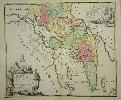
Imprint: London, c.1827
Binding: Hardback Small octavo (135 x 85 mm.), full contemporary green diced morocco, gilt panelled boards with gilt title 'Pocket Tourist' to upper cover, skilfully rebacked with gilt ruled compartments. With engraved title page, Explanation and Contents on 1 leaf, general map of England and Wales in early wash colour and 42 maps of the English counties and North and South Wales in early outline colour, in very good condition.
The origin of this series of copper plate county maps was unknown until 1983. Joseph Allen was a publisher and engraver of 3 Hampden Str., Sommerstown, London. When originally uncovered, Yasha Beresiner identified the author as John Allen. It was in 1993 that Eugene Burden reported in private correspondence that he had looked up the 1811 Directory and identified him as Joseph Allen (fl.1798-1821). His major work appears to be the co-engraving with Robert Rowe (c.1775-1843) of a plan of London entitled â⦠London, Westminster and Southwarkâ, first published in 1804. Allen was apprenticed to William Palmer in 1791, as was interestingly Robert Rowe (apprenticed 1789). Allen was identified as being the son of a farmer from Wallop, Hampshire.Rowe had already engraved one series of county cards as a game for John Fairburn in 1798. Clearly encouraged, he persuaded Joseph Allen to produce another. Indeed, it appears from the second example of Fairburn cards, that Allen may already have been a partner or owner of that series. It is worth noting that the wording of the rules on the cover of the case are identical to that found on the cover of the second set of Fairburn cards in the Burden Collection. The maps are derived from the 1806 issue of John Caryâs Travellerâs Companion. There are now three known examples of the first state. Only two known examples of the second state survive.The ensuing history is even rarer. Only two examples are recorded of John Thomson's New English Atlas 1823. These reside in the Bodleian Library and a private collection. Their final issue is this exceedingly rare work by Orlando Hodgson and it is engraved throughout. The plates were unaltered, and the title is very similarly worded. The main difference is that here the title calls for a âCopious Topographical Accountâ. None of the surviving examples bears any text so the likelihood is that it was a separate publication for which this was an accompaniment. Undated, the work is now believed to have been published between 1826 and 1828, the years during which Hodgson is recorded at the Maiden Lane address in the Post Office London Directory. Orlando Hodgson was a part of the family firm of Hodgson and Company at 10 Newgate Street, London, in 1825. It seems he then operated under his own name from 21 Maiden Lane, London, from where he published this work. Only three institutional examples are known. The British Library (Maps 2.aa.4), Aberdeen University (Lib R 912(42) Hod) and the Bodleian Library (C.17.f.9) which lacks the title page and preliminaries. Provenance: manuscript inscription inside upper cover of J? Briggs; private English collection. Carroll (1996); Chubb (1927) 371; Smith, D. (1991d); Tooleyâs Dictionary (1999-2004).
Stock number:10239.
|
|
Imprint: Nuremberg, c.1678
65 x 125 mm., backed on original marbled paper to make a playing card.
Hoffman published two sets of playing cards, one of the world, the other of Europe. This card of Hannonia in present day Belgium is from the Europe which was entitled 'Europeisch-Geographisches Spiel-Charte' and represents the nine of diamonds. It is extremely rare. The world map in the set bears the imprints of 'J.H. Seyfrid, delineavit' and 'Wilhelm Pfann. sculpsit', probably those responsible for all the cards. The date 1678 comes from the accompanying text volume which resides in the Willshire Collection at the British Museum. Hoffman was born in Frankenberg, Sachsen, 17 March 1629. He was often in trouble with the authorities in Nuremberg for various illegal activities including plagiarism. He died 27 March 1698. S. Mann & D. Kingsley Map Collector Series no. 87 p. 22 no. 5; C. P. Hargrave 'A History of Playing Cards' p. 109; van der Krogt 'The Europaeisch-Geographische Spiel-Charte by Franz Nigrinus and Johann Seyfried, 1678' in 'The Map Forum' no. 9 pp. 56-60; van der Krogt 'The Europaeisch-Geographische Spiel-Charte by Franz Nigrinus and Johann Seyfried, 1678', in 'Map Forum' no. 9 pp. 56-60.
Stock number:7771.
|
|
Imprint: Nuremberg, 1678-[94]
100 x 120 mm., with even light toning, otherwise in good condition.
'In 1678 Johann Christoph Beer translated into German Pierre Duval's highly successful little atlas entitled 'Le Monde Terreste, ou la Geographie Universelle', first published in Paris, 1660. An English edition of the atlas was also produced but only this Nuremberg issue bore maps. It was published by Johann Hoffman who employed the local engraver Sigismund Hipschmann to render the plates. The atlas was republished in the years 1679, 1681, 1690 and 1694.' Burden 'North America' no. 499.
Stock number:4970.
|
|
Imprint: London, c.1644-[c.55].
145 x 255 mm., trimmed to plate mark, light foxing otherwise in good condition.
He was born in Prague 13 July 1607 as Václav Hollar which he would later anglicise. His childhood was a life of some privilege which enabled him access to some of the finest art works of the era including that of the principal court engraver Aegidius Sadeler with whom it is believed Hollar learnt to engrave. Hollars early work was in Prague but the turmoil at home encouraged him to go to Stuttgart, Germany in 1627. Two years later he appears to have moved further west to Strasbourg. His natural talent flourished alongside the likes of Jan van de Velde and shortly after Matthaus Merian in Frankfurt. He worked all along the River Rhine including the Dutch towns.It was in 1636 that a fortuitous meeting occurred with the English envoy Thomas Howard, the Earl of Arundel. Hollar joined the entourage and was employed to record their travels. At the end of the year the Earl of Arundel returned to England and was joined by Hollar. For the next six years he worked closely alongside him. The Earl and his circle were fervent Royalists which it appears matched Hollars own sympathies. According to the eighteenth century engraver George Vertue he fought during the Civil War being present at the garrison of Basing House in 1644 with other notable artists such as Inigo Jones and William Faithorne. During this period some of his engravings were published by the largest printseller at the time Peter Stent.The Arundels had left London for Holland just before the outbreak of the Civil War. Sometime later in 1644 Hollar joined them. He would spend the next eight years in Antwerp about which we know relatively little. Life in Antwerp became difficult and he was enticed back to England. Two reasons for this are believed to be the Act of Pardon of 1652 removing the threat of prosecution of Royalists and quite possible the offer of work by William Dugdale, the Antiquary. Some of his most important work was done prior to the Great Fire of London as he is one of the very few visual sources of the buildings before their destruction. A fine view of the square in front of St. Peters Church with many people. Griffiths & Kesnerová (1983) 98c; Hind (1922) no. 79; Pennington (1982) 909.ii.
Stock number:7733.
|
|
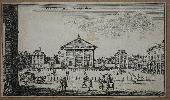
Imprint: London, Henry Overton at the White Horse without Newgate, c.1672-[c.1710]
365 x 560 mm., in excellent condition with good margins.
This plate is undated but the dedication to Gilbert Sheldon the Archbishop of Canterbury narrows the dates to 1663-77. It is published by John Ogilby who bears the title Royal Cosmographer which he was appointed in 1671, he died in 1676. Hence the best guess would be the early 1670s. The fine panorama of Canterbury from a distance is typical of Hollars finest work. Thomas Johnson (fl/ 1634-76) was the artist for the view along with that of the Cathedral below. Johnson, a native of Canterbury, was a noted landscape painter of the day. The plan of the city is derived from that of John Speed first published in 1612. This work is believed to date from the early days of preparation for his ambitious atlas of the English counties. Money and his own health caught up with him, but fortunately he did indeed manage to publish the immensely important Britannia in 1675. The first state is incredibly rare; this example is the second by Henry Overton whose imprint appears lower right. Second state of three. Hyde Gilded Scenes no.12; Pennington 961.2; Worms & Baynton-Williams (2011).
Stock number:7228.
|
|
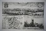
Imprint: Nuremberg, c.1720
490 x 570 mm., in fine early wash colour. Small area of browning lower right in margin, otherwise a good example.
A fine plan of the Sound with a lovely panoramic prospect of the city of Copenhagen below. Upper left are three smaller views of Helsingborg, Landskrona and Malmo. On the right side is a further inset with a view of Kronenburg Castle. Fauser, A. 6888.
Stock number:4681.
|
|
Imprint: Nuremberg, c.1710
500 x 590 mm., in fine early wash colour. With some extremely light centrefold browning, otherwise a good example.
FIRST STATE. A superb detailed map of the Attica peninsula containing Athens. This is an example of the first state before the addition of the privilege. The map is drawn by George Wheeler about whom little is known, he appears to have recorded a number of ancient texts during the seventeenth century. Zacharakis, C. 1084.
Stock number:4175.
|
|
Agri Parisiensis Tabula particularis, qua maxima Pars Insulae Franciae, seu Regiae celeberrimaeq ...
Imprint: Nuremberg, c.1720
575 x 485 mm., early outline colour, in good condition.
A detailed map of the region about 40 kilometres around Paris and Versailles. It was published by Johann Baptist Homann in his 'Grosser Atlas'. The map extends to Mantes, Senlis, Melun and Rambouillet. It is decorated with a fine figurative cartouche. The map contains a lot of compressed detail including small villages, forests, farmland, walled cities and more. Paris is central to the map and includes its ancient walls and nearby gardens of Vincennes and the Bois de Boulogne. Further west the grounds of Versailles extend in equal size to the city of Paris itself. The title is retained in a beautiful cartouche with several putti. Shirley (BL Atlases) T.HOM-1c, no.11.
Stock number:8628.
|
|
Imprint: Nuremberg, 1707
Edition: First Edition 60 x 50 cms., early wash colour. In good condition
The famous German firm of cartographic publishers was founded by Johann Baptist Homann in 1702 in Nuremberg. In 1707 he published the "Neuer Atlas" whose success continued for many years. This fine map of Bavaria in southern Germany was issued in the first edition. It bears an elaborate ornate title cartouche. Heinz "A Programme for Map Publishing: the Homann Firm of the Eighteenth Century", in "Imago Mundi" no. 49 pp. 104-115; Shirley, BL Atlases, T.HOM-1a, 27.
Stock number:4221.
|
|
Imprint: Nuremberg, c.1715
Edition: First Edition 60 x 50 cms., early wash colour. In good condition
The famous German firm of cartographic publishers was founded by Johann Baptist Homann in 1702 in Nuremberg. In 1707 he published the "Neuer Atlas" whose success continued for many years. This fine map of Bavaria in southern Germany was issued in the first edition. It bears an elaborate ornate title cartouche. Heinz "A Programme for Map Publishing: the Homann Firm of the Eighteenth Century", in "Imago Mundi" no. 49 pp. 104-115; Shirley, BL Atlases, T.HOM-1a, 27.
Stock number:4223.
|
|
Imprint: Nuremberg, c.1730
570 x 480 mm., in fine early outline colour. With good margins all round.
This fine detailed map of the Straits of Gibraltar is often listed as being by Johann Baptiste Homann after one drawn by the engineer J. de Petit and published by J.F. Weidler. It is engraved by R.A. Schneider with a fine decorative title cartouche and three fine ships in the Atlantic Ocean. It shows the Spanish coastline and interior in some detail from Malaga in the east to and beyond Cadiz in the west. Although listed as a Homann map the name is not written in the usual way. Stylistically it is just like a Nicolas de Fer map with similar paper being used and even the large margins, something Homann's maps never had. A curious item.
Stock number:4229.
|
|
Imprint: Nuremberg, 1761
570 x 500 mm., in early wash colour, good condition.
An ornate detailed map of the region of Westphalia in Germany. The map extends from Emden, Bremen and Hamburg in the north to Cologne, Bonn and Dusseldorf in the south. It takes in the Dutch towns of Maastricht, Nijmegen and Arnhem. To the east the city of Hannover is found. It is finished with an ornate title cartouche upper left. The famous German firm of cartographic publishers was founded by Johann Baptist Homann in 1702 in Nuremberg. In 1707 he published the "Neuer Atlas" whose success continued for many years. In recognition of his success Homann was elected to the Berlin Academy of Sciences. In 1715 Homann was appointed Geographer to the Emperor. Homann died in 1724 and was succeeded by his son Johann Christoph (1703-30) who died shortly after. Henceforth the firm was run by various family members under the title of Homann Heirs until the late 1770s. Homann's map are generally well engraved in a detailed style.
Stock number:7010.
|
|
Imprint: Nuremberg, c.1720
480 x 570 mm., in early wash colour, good condition.
The famous German firm of cartographic publishers was founded by Johann Baptist Homann in 1702 in Nuremberg. In 1707 he published the "Neuer Atlas" whose success continued for many years. In recognition of his success Homann was elected to the Berlin Academy of Sciences. In 1715 Homann was appointed Geographer to the Emperor. Homann died in 1724 and was succeeded by his son Johann Christoph (1703-30) who died shortly after. This large scale detailed map covers Lower Saxony and extends from Bremen in the north west through Hamburg, Lubeck, Wismar and Rostock to the Island of Rugen. The city of Berlin is displayed just above the title cartouche with Gottingen shown lower left.
Stock number:7012.
|
|