|
|
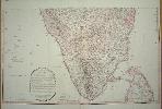
Imprint: London, 1792-[1800]
500 x 830 mm., one sheet of two, in fine early wash colour, in good condition.
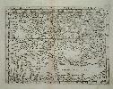
This fine detailed large scale map on 2 separate sheets depicts the southern Indian peninsula from Bombay to Ceylon. The several colours distinguish the various powers. This is identified as the third edition and is updated with the outcome of the recent acquisitions of Great Britain and her 'Allies the Nizam and the Marhattas' in the Partition Treaties of 1792 and 1799. Gole no. 97; refer Shirley BL T.Fad 4a no. 42.
Stock number:6381.
|
|
|
Imprint: London, 1799
570 x 770 mm., early outline colour, in good condition.
This detailed map of southern France was published to accompany William Faden's 'General Atlas'. Faden took over the business of Thomas Jefferys after his death in 1777. He went on to produce many fine large maps of all parts of the world. The map extends from Perpignan to San Remo in Italy.
Stock number:8627.
|
|
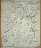
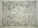
Imprint: Sheffield, 1771
305 x 255 mm., with old folds repaired with minimal loss, otherwise in good condition.
William Fairbank was part of a four generation family of local surveyors. The companys papers, maps, plans, books and letters are in the Sheffield City Archives. The tradition was begun by his father William Fairbank I, born 1687/88. He was a schoolmaster from a family of Quakers said to be from Halifax. He practiced surveying from Sheffield and died in 1759 leaving a son William Fairbank II (1730-1801), also a schoolmaster and surveyor. It is this Fairbank who is the author of this very rare plan of Sheffield. It is engraved by Thomas Jefferys and is important because in the following year, 1772, Jefferys would include a version of this plan in his large scale map of Yorkshire (see below). This therefore is the important survey first separately published. Provenance: private English collection. Eden (1975); Leader, R. E. (1903) Surveyors and Architects of the Past in Sheffield, Sheffield; Tooley (1999-2004).
Stock number:6325.
|
|
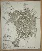
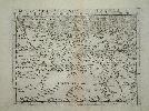
Imprint: Sheffield, 1797
235 x 285 mm., trimmed close with no loss of engraved surface, otherwise in good condition.
This plan of the town was printed to accompany John Robinsons A Directory of Sheffield published in that town, 1797. The plan was engraved by Thomas Harris and now includes 21 points of reference. In comparison with the earlier Fairbank plans offered above its coverage is extended slightly further south along the Chesterfield Road and westward to include Radford Street. See the earlier Fairbank entry for further details.
Stock number:6371.
|
|
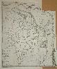
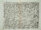
Imprint: London, 1772
Edition: First Edition 320 x 270 mm., cut from the large scale county map and pasted on to paper, otherwise in good condition.
The first edition of Thomas Jefferys great map of the county of Yorkshire contained an inset plan of Sheffield derived from the survey of William Fairbank published a year earlier. The county survey was undertaken by J. Ainslie, T. Donald and J. Hodskinson between 1767 and 1770. Rawnsley (1970) 27; Rodger (1972) 536, Whitaker (1933) 240.
Stock number:6372.
|
|
|
Imprint: London, Fisher, Son, & Co, [1845]
Edition: First Edition Binding: Hardback Folio (370 x 310 mm.), contemporary half calf, cloth boards blind ruled, spine with gilt ruled compartments, gilt title, light wear. With title page, preface and contents leaf and 96 pages of descriptive text interspersed with 48 maps consisting of 1 folding general map of England and Wales, 39 maps of the counties (Leicestershire and Rutland together) and Wales made up of 6 sheets, those of Lincolnshire and Devon are double page, all in early wash colour, general map with tear repaired, Gloucestershire with old tear repair, otherwise in good condition.
FIRST EDITION. This work by Fisher, Son and Co. was first issued in parts from 1842 to 1845, it is the only such atlas produced by them. The first nine county maps bear the imprint of 'Gilberts County Atlas' suggesting that it may have been begun by James Gilbert. These early plates were engraved by Joshua Archer, five of them are dated between April and June 1842. These suggest a publication rate of one or two maps per month. The last two of Oxford and Gloucestershire both have a change of imprint to Fisher indicating a change in publisher. Gilbert was an active publisher of cartographic items from the mid-1820s. The Fisher firm was founded by Henry Fisher (d.1837) and became Fisher, Son & Co. when his son Robert joined the firm in 1825. The remainder of the maps are engraved by F. P. Becker & Co. They all bear a resemblance to those of Walker's 'British Atlas' of 1837. The date of the general map is 1845, suggesting the date of completion. The atlas bears two double page county maps in Lincolnshire and Devonshire. Quite why these two are depicted so is unclear. The binding order is also curious starting with those of Leicestershire and Rutland combined, they reflect the order in which the part issues were published. Roman numerals on most of the plates confirm this. From here they jump geographically and alphabetically. Provenance: bookplate of Harold Egan pasted inside front cover; Brian Kentish catalogue 2012 item 23; private English collection. Beresiner (1983) p. 101; Carroll (1996) 111; Chubb (1927) 504; Smith (1985) pp. 136-7.
Stock number:9804.
|
|
|
Imprint: London, Fisher, Son, & Co., c.1845
Edition: First Edition Binding: Hardback Folio (370 x 300 mm.), modern burgundy quarter calf, red cloth boards, ornate blind ruled, spine with gilt ruled spine, gilt title, marbled endpapers. With typographic title page, preface and contents leaf, pp. (4), 96, with 48 maps consisting of 1 folding general, 41 county and Wales in 6 sheets, Gloucestershire with some margin repair, otherwise in good condition.
FIRST EDITION. The imprint of Henry Fisher (d.1837) is first seen on a map of ancient Europe in 1816. By the end of 1818 Fisher had established the Caxton Press. It was destroyed by fire on 7 February 1821. Fisher decided to move to London where he soon began again under the same Press. His son Robert joined the firm in 1825 when it became known as Fisher, Son & Co. James Gilbert first comes to our attention with a guide to London published c.1824 and became an active publisher of cartographic items. From his address at Paternoster Row, he began a county atlas in 1842. The first nine county maps numbered in roman, bear the imprint of 'Gilbertâs County Atlas'. These early plates were engraved by Joshua Archer, the first two are undated and are published by Gratton & Gilbert. The next five are dated between April and June 1842 are published by M. Alleis. These suggest a publication rate of one or two maps per month. The last two of Oxford and Gloucestershire both have a change of imprint to Fisher indicating a further change in publisher. The remaining maps are engraved by F. P. Becker & Co. and roman numeration is dropped. The date of the general map is 1845, suggesting the date of completion. They all bear a resemblance to those of Walker's 'British Atlas' of 1837. The atlas bears two double page county maps in Lincolnshire and Devonshire. Quite why these two are depicted so is unclear. The binding order is also curious starting with those of Leicestershire and Rutland combined, they reflect the order in which the part issues were published. Provenance: private English collection; Clive A. Burden Ltd. (2008); Dr. Adrian Almond collection; Dominic Winter auction 6 March 2013 lot 83; private English collection. Beresiner (1983) p. 101; Carroll (1996) 111; Chubb (1927) 504; Gardiner (1973); Nicholson (2007); Smith (1985) pp. 136-7; Tooley's Dictionary (1999-2004).
Stock number:10309.
|
|
|
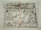
Imprint: Venice, c.1562
Inscription: Signed, Inscribed Or Annotated 580 x 370 mm., in good condition.
The first printed large-scale map of South America and the only Lafreri school map of the region. We know little about the engraver Paolo Forlani. David Woodward expanded considerable effort to catalogue his works. Forlani, or Furlani, came from Verona and died it is assumed in Venice in the mid-1570s, quite possible in one of the outbreaks of the plague which claimed thirty percent of the population. Caraci claimed his career began in 1558 without providing supporting evidence. The earliest dated map he signed is 1560, one of the world for Giovanni Camocio. Along with Giacomo Gastaldi he worked in Venice and produced some of the most attractive maps of the period. This work is one of the most important in his opus. It extends from Tierra del Fuego in the south to Florida and the Caribbean in the north taking in the whole of South America. The Italian title translates as the Description of all of Peru. In 1542, the Vice-royalty of Peru was created, establishing control over much of Spanish-ruled South America i.e. all but Portuguese-controlled Brazil. In 1531, after crossing into the Pacific Ocean, the Spanish reached Peru and the Inca Empire, which extended over a huge area. The following year, Francisco Pizarro arrived. The Empire had already been weakened by the arrival of smallpox, introduced in Panama. By 1534, the Incan city of Cuzco had been named as the new Spanish capital. In 1542, the Viceroyalty of Peru was created. Potosi was originally a small Incan outpost and in 1545 it was made a mining town to support the removal of vast amounts of silver from its mountain, becoming legendary. At an altitude of 4,000 metres, it would become the fourth largest city in the Christian world (pop. 200,000) within a short period of time. The economic effects of the silver supply were felt around the world. Chile was first visited by Ferdinand Magellan when passing through the Straits bearing his name in 1520. However, it is usually Diego de Almagro who is credited with first visiting the region in 1537. He found nothing to compare to the riches of the north and returned. It was Pedro de Valdivia who, with Pizarros permission, invaded the country and recognised its agricultural potential. In 1541, he founded Santiago de Chile. In outline the map bears similarities to Gastaldi magnificent nine-sheet woodcut world map c.1561, surviving in the one known example at the British Library (Maps C.18.n.1). It is, however, dissimilar to the Diego Gutierrez published in 1562. David Woodward who studied Forlani at length, suggested an estimated date of publication of 1562. This was based on his study of the watermarks of several examples. This example is a tree in a circle under a star. For comparison this watermark is only found in the first state of the companion map of North America. One of the more immediate features noted is the lack of any allegorical embellishments with no monsters or cannibals present. Considering the size of the continent and the extent to which it had not been explored at the time, great effort was made to accurately portray the interior.Arguably the most dominant feature in South America is the exaggerated mouth of the Rio Plata. As might be expected the proportions internally are not so accurate. To its west is Lago Titicacha with a nearby Potosi, the famous silver mine, depicted to the south east. Lake Titicaca discovered by Aleixo Garcia in 1525 and Potosi was mined from 1545. Potosi is in fact far to the north of the lake, as is Cusco which is placed too close to the northern shore. Although not depicted Tierra del Fuego is clearly indicated as being part of the southern continent. It was not until 1616 when a Willem Schouten rounded Cape Horn for the first time. The original name Maragon for the Amazon is provided as is that we now know it by. It was given the name Amazon by Francesco de Orellana who in 1542 was the first European to descend the river from the west coast. Settlements on the coast of Brasil include Pernambuco, one of the more important Hereditary Captaincies created by King John III of Portugal and granted to Duarte Coelho in 1535. Notable also is a prominently named Benezuela Reg: The equator is marked with a longitude scale drawn west from a Prime Meridian at the westernmost point of the Canary Islands. The so-called Ferro Meridian had been used since the time of Ptolemy. It was at the time the furthest point west in the known world.The key town of Nombre de Dios in central America, founded in 1510, became the port through which Peruvian silver flowed to Europe. Many recognisable places are found in the West Indies. At the tip of Florida are the Martires, or Florida Keys. Many of the names in the Bahamas are also familiar. Along the Atlantic coast of North America is C. d S. Ellena, the site of the circa 1520 attempted settlement of the Carolina coast by Lucas Vaìsquez Aylloìn on the island which still bears the same name.This is a landmark map of South America and the only Lafreri school map or the region. It has been noted that there are two different states. A state marks a definitive change to the plate, usually by hand. In this plate it is the wear to the upper left corner which alters its appearance. In early issues R de Nieve' is clearly legible. Later printed examples are worn to the extent that the placename has all but disappeared. The map bears a beautifully engraved ornate compass rose in the Pacific and is dedicated to Gio. Pietro Contarini, a member of the Council of Venice and one of the major Venetian families of the day. Bifolco & Ronca (2018) vol. 1 p. 358; Buisseret (2007) Spanish Colonial Cartography, 1450-1700, in The History of Cartography, vol. 3, pt. 1, pp. 1143-71; Burden (1996) no. 33 (North America); Meurer (2004) Strabo Illustratus Atlas no. 190; Shirley (1993) World no. 107; Tooley (1939) no. 93; Woodward (1990) Maps and Prints of Paolo Forlani no. 11; Woodward (1992) Paolo Forlani, Compiler, Engraver, Printer or Publisher, in Imago Mundi 44, pp. 45-64; Woodward (1994) The Forlani Map of North America, in Imago Mundi 46, pp. 29-40.
Stock number:8754.
|
|

Imprint: Brussels, 1712
42 x 56 cms., backed on linen and folded, but not cut.
Eugene Henri Fricx (1644-1730) is best known for his maps of the military campaigns of the War of the Spanish Succession 1701-14. He was a bookseller and publisher in Brussels. One sheet of a 24 sheet map "Table des cartes des Pays Bas et des Frontieres de France". A rare map of Kent. Engraved by Harrewyn. Tooley's Dictionary of Mapmakers. Koeman II pp. 109-10.
Stock number:3961.
|
|
|
Imprint: London, A. Fullarton and Co., 1847
Binding: Hardback Quarto, 4 volumes (245 x 170 mm. each), modern quarter calf, marbled paper boards, spines with gilt calf title labels affixed, later endpapers. With typographic title page, pp. xlix, 648; (2), 616; (2), 656; (2), 640,(2), 80, with 47 steel engraved maps comprising large folding map of Englnd & Wales, 42 maps of the English counties (Yorkshire in 3 Ridings), 4 folding of Wales and 3 steel engraved plates, with light foxing, otherwise in good condition.
In 1833-34 James Bell published A New and Comprehensive Gazetteer in parts. Much of its source material was drawn from Samuel Lewisâ Topographical Dictionary of England. In 1839 Lewis managed to obtain an injunction against Bell. The maps engraved for the work were later retained by Archibald Fullarton & Co. who utilised them in the Parliamentary Gazetteer with new text, first issued in 1840. The Fullarton maps each contain a decorative vignette, these later issues bear railways. The plates were constantly updated as the rapidly expanding railway network grew. The maps are filed alphabetically except for Hampshire which is filed under its alternative name Southampton. Beresiner (1983) p. 102; Carroll (1996) 99; refer Chubb (1927) 510.
Stock number:10289.
|
|
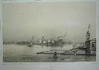
Imprint: Paris, 1842-55
31 x 38 cms., uncoloured lithographic view
Ex 'Voyages de la Commission Scientifique du Nord en Scandinavie, en Laponie au Spitzberg et aux Feroe pendant les annees 1838, 1839, 1840'. This survey was commissioned by the French government. Nissen ZBI 1469
Stock number:3189.
|
|
Imprint: Paris, 1842-55
33 x 46 cms., uncoloured lithographic view
Ex 'Voyages de la Commission Scientifique du Nord en Scandinavie, en Laponie au Spitzberg et aux Feroe pendant les annees 1838, 1839, 1840'. This survey was commissioned by the French government. Nissen ZBI 1469
Stock number:3187.
|
|
Imprint: Paris, 1842-55
31 x 45 cms., uncoloured lithographic view
Ex 'Voyages de la Commission Scientifique du Nord en Scandinavie, en Laponie au Spitzberg et aux Feroe pendant les annees 1838, 1839, 1840'. This survey was commissioned by the French government. Nissen ZBI 1469
Stock number:3188.
|
|
|
Imprint: London, Jacob Tonson & John Watts, 1719
Binding: Hardback Inscription: Signed, Inscribed Or Annotated Quarto (185 x 155 mm.), full contemporary calf, ornate blind panelled boards, rebacked with ribbed spine with gilt calf title label affixed. With typographic title page printed in red & black, Preface and index pp. (4), 8, and 100 engraved road strip plates, some trimmed close at the lower edge, otherwise in good condition.
Gardner is described as an engraver in Tooleys 'Dictionary of Mapmakers' but the recent work of Worms and Baynton-Williams casts doubt on that. Indeed, this is his only known cartographic work. In the period 1718-20 there were no less than four reduced versions of John Ogilby's landmark Britannia first published in 1675. The attempt of Herman Moll was publicised first but was never completed. One of the reasons for this may well have been the impending competition of Gardner, arguably the most desirable of the published works. The 'Pocket-Guide to the English Traveller' is in fact the first of the versions to reach the market being advertised 30 December 1718 in the 'Daily Courant'. The publishers were Jacob Tonson and John Watts. Tonson (1656-1736) was a well-known publisher who earlier in his career had worked with Abel Swall, the last publisher of the folio Ogilby 'Britannia' c.1705. Watts (c.1678-1763) was renowned for the quality of his typesetting and at one point counted amongst his compositors one Benjamin Franklin.The Preface best describes the aim of the work The [Britannia]
has been done with so much Care and Exactness, and esteemd a Work so useful, that it wanted only to be reducd to a portable Volume, to render it of general Advantage to an English Traveller. As the original Plates are in large Sheets, the general Use of them has been hitherto lost, and the Book rather an Entertainment for a Traveller within Doors, than a Guide to him upon the Road ... Just two days after the announcement of its publication John Senex announced 'An Actual Survey Of all the Principal Roads of England and Wales'. This undoubtedly hurt sales but the biggest threat was yet to arrive in the name of Emanuel Bowens 'Britannia Depicta'. A battle took place in the press at this time for the new market between the published works of Gardner and Senex and the impending work of Bowen. Tonson retired about 1720 which may also explain the lack of another edition, his business being handed to his nephew. Harley stated that Gardner had signed four plates although I couldnt identify them, plate number 33 is signed by W. Caslon (1693-1766) who most likely engraved others. He is described as A celebrated typefounder', 'the Elzevir of England' (Worms & Baynton-Williams). Provenance: private English collection. Bennett (1996) pp. 36-7; Carroll (1996) Appendix 3; Chubb (1927) 137; ESTC T154207; Fordham (1924) p. 18; Harley (1970); Hodson (1984-97) I p. 80; Shirley (2004) T.Gard 1a; Worms & Baynton-Williams (2011).
Stock number:9824.
|
|
|
Imprint: London, 1719
Binding: Hardback Inscription: Signed, Inscribed Or Annotated Quarto (180 x 165 mm.), full contemporary calf, ornate blind panelled boards, ribbed spine with blind ruled compartments and gilt calf title label affixed. With typographic title page printed in red & black, Preface and index pp. (4), 8, and 100 engraved road strip plates, some trimmed close at the lower edge, some centrefold repairs in the third quartile with some light worming in the gutter, otherwise in good condition.
Gardner is described as an engraver in Tooleyâs Dictionary of Mapmakers but the recent work of Worms and Baynton-Williams casts doubt on that. Indeed, this is his only known cartographic work. In the period 1718-20 there were no less than four reduced versions of John Ogilby's landmark Britannia first published in 1675. The attempt of Herman Moll was publicised first and although eleven plates exist, it was never completed. One of the reasons for this may well have been the impending competition of Gardner, arguably the most desirable of the published works. The Pocket-Guide to the English Traveller is in fact the first of the versions to reach the market being advertised 30 December 1718 in the Daily Courant. The publishers were Jacob Tonson and John Watts. Tonson (1656-1736) was a well-known publisher who earlier in his career had worked with Abel Swall, the last publisher of the folio Ogilby Britannia c.1705. Watts (c.1678-1763) was renowned for the quality of his typesetting and at one point counted amongst his compositors one Benjamin Franklin.The Preface best describes the aim of the work âThe [Britannia] ⦠has been done with so much Care and Exactness, and esteemâd a Work so useful, that it wanted only to be reducâd to a portable Volume, to render it of general Advantage to an English Traveller. As the original Plates are in large Sheets, the general Use of them has been hitherto lost, and the Book rather an Entertainment for a Traveller within Doors, than a Guide to him upon the Road ...â Just two days after the announcement of its publication, John Senex announced An Actual Survey Of all the Principal Roads of England and Wales. This undoubtedly hurt sales but the biggest threat was yet to arrive in the name of Emanuel Bowenâs Britannia Depicta. A battle took place in the press at this time for the new market between the published works of Gardner and Senex and the impending work of Bowen. Tonson retired about 1720 which may also explain the lack of another edition, his business being handed to his nephew. Harley stated that Gardner had signed four plates although I couldnât identify them, plate number 33 is signed by W. Caslon (1693-1766) who most likely engraved others. He is described as âA celebrated typefounder', 'the Elzevir of England' (Worms & Baynton-Williams). Provenance: manuscript inscription on front free endpaper 'Harriet J. Roundell Gledstone 1804'; title page with inscription 'Charles Nice Davies 1825' (1794-1842); bookplate of Roger Noel Heaton affixed inside upper cover dated '14.1.1949'; Dominic Winter 11 December 2013 lot 64; private English collection. Bennett (1996) pp. 36-7; Carroll (1996) Appendix 3; Chubb (1927) 137; ESTC T154207; Fordham (1924) p. 18; Harley (1970); Hodson (1984-97) I p. 80; Shirley (2004) T.Gard 1a; Worms & Baynton-Williams (2011).
Stock number:10143.
|
|
Imprint: Venice, 1548
135 x 175 mm., with two tiny holes in the centrefold repaired, otherwise in fine condition.
A rare modern map of northern Africa extending to the Atlantic Ocean in the lower left. It was published in Giacomo Gastaldi's influential edition of Ptolemy's "Geographia". Gastaldi was arguably the greatest Italian cartographer of the sixteenth century. It is also the world's first printed pocket atlas, and the first to use a mechanism to hold the plates in position so that the impression was good and level. Karrow, R.W. (16 c.) 30/33; Nordenskiold Collection 214; Phillips, P.L. (Atlases) 369; Shirley "Atlases in the BL" T.Ptol 9a.
Stock number:4401.
|
|
Imprint: Venice, 1548
130 x 170 mm. Uncoloured early map, in good condition.
A rare modern map of Germany published in Giacomo Gastaldi's influential edition of Ptolemy's "Geographia". Gastaldi was arguably the greatest Italian cartographer of the sixteenth century. It is also the world's first printed pocket atlas, and the first to use a mechanism to hold the plates in position so that the impression was good and level. Karrow, R.W. (16 c.) 30/13; Nordenskiold Collection 214; Phillips, P.L. (Atlases) 369; Shirley "Atlases in the BL" T.Ptol 9a.
Stock number:3041.
|
|
Imprint: Venice, 1548
135 x 175 mm., in fine condition.
A rare modern map of Egypt published in Giacomo Gastaldi's influential edition of Ptolemy's "Geographia". Gastaldi was arguably the greatest Italian cartographer of the sixteenth century. It is also the world's first printed pocket atlas, and the first to use a mechanism to hold the plates in position so that the impression was good and level. Karrow, R.W. (16 c.) 30/35; Nordenskiold Collection 214; Phillips, P.L. (Atlases) 369; Shirley "Atlases in the BL" T.Ptol 9a.
Stock number:4400.
|
|
Imprint: Venice, 1548
135 x 170 mm., in good condition.
A very rare modern map of Russia showing the region between the Black Sea with a recognisable Crimean peninsula to the Caspian Sea in the east. One of the earliest modern maps of Russia. It extends northwards encompassing all of European Russia. Bagrow praised the map considerably and discusses the maps origins as "an unpublished sketch by Paulus Giovio". It appears to be related to that of Dmitriy Gerasimov in the atlases of Battista Agnese. It was published in Giacomo Gastaldi's influential edition of Ptolemy's 'Geographia'. Gastaldi was arguably the greatest Italian cartographer of the sixteenth century. It is also the world's first printed pocket atlas, and the first to use a mechanism to hold the plates in position so that the impression was good and level. Bagrow pp. 64 & 86-8; Karrow, R.W. (16 c.) 30/41; Nordenskiold Collection 214; Phillips, P.L. (Atlases) 369; Shirley 'Atlases in the BL' T.Ptol 9a.
Stock number:4982.
|
|
Imprint: Venice, 1548
130 x 175 mm., light brown in part of the centrefold otherwise fine condition.
A rare Ptolemaic map of Egypt published in Giacomo Gastaldi's influential edition of Ptolemy's "Geographia". It is adorned with a winged Phoenix lower left. Gastaldi was arguably the greatest Italian cartographer of the sixteenth century. It is also the world's first printed pocket atlas, and the first to use a mechanism to hold the plates in position so that the impression was good and level. Karrow, R.W. (16 c.) 30/34; Nordenskiold Collection 214; Phillips, P.L. (Atlases) 369; Shirley "Atlases in the BL" T.Ptol 9a.
Stock number:4402.
|
|