|
|
Imprint: Venice, 1548
130 x 170 mm., in fine condition.
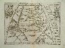
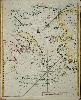
A rare map of central Asia published in Giacomo Gastaldi's influential edition of Ptolemy's "Geographia". Gastaldi was arguably the greatest Italian cartographer of the sixteenth century. It is also the world's first printed pocket atlas, and the first to use a mechanism to hold the plates in position so that the impression was good and level. The map is adorned with a cannibal scene upper right within the map and two further images in the upper corners. Karrow, R.W. (16 c.) 30/51; Nordenskiold Collection 214; Phillips, P.L. (Atlases) 369; Shirley "Atlases in the BL" T.Ptol 9a.
Stock number:4393.
|
|
Imprint: Venice, 1548
130 x 175 mm., in fine condition.
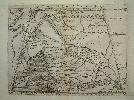
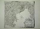
A rare Ptolemaic map of central Russia showing the region between the Black Sea with a recognisable Crimean peninsula to the Caspian Sea. It was published in Giacomo Gastaldi's influential edition of Ptolemy's "Geographia". It is adorned with two birds on the left and an apparent shipwreck points to dangerous waters. Gastaldi was arguably the greatest Italian cartographer of the sixteenth century. It is also the world's first printed pocket atlas, and the first to use a mechanism to hold the plates in position so that the impression was good and level. Karrow, R.W. (16 c.) 30/41; Nordenskiold Collection 214; Phillips, P.L. (Atlases) 369; Shirley "Atlases in the BL" T.Ptol 9a.
Stock number:4429.
|
|
Imprint: Venice, 1548
130 x 180 mm., in good condition.
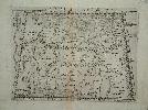
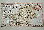
Ptolemy's depiction of Persia or Iran as published in Giacomo Gastaldi's influential edition of Ptolemy's "Geographia". Gastaldi was arguably the greatest Italian cartographer of the sixteenth century. It is also the world's first printed pocket atlas, and the first to use a mechanism to hold the plates in position so that the impression was good and level. Karrow, R.W. (16 c.) 30/64; Nordenskiold Collection 214; Phillips, P.L. (Atlases) 369; Shirley World no. 88; Shirley "Atlases in the BL" T.Ptol 9a.
Stock number:4957.
|
|
Imprint: London, W & J Mount and T. Page at the Postern on Tower Hill, 1716-[47]
400 x 530 mm., minor restoration to lower margin and corners, otherwise in good condition.
A sea chart of the eastern Mediterranean Sea featuring Cyprus by John Gaudy and engraved by Samuel Parker. It extends westward to include part of the island of Crete. The nearby island of Rhodes is also displayed and it extends into the Aegean Sea as far as Patmos. It was published in Mount & Page's 'English Pilot First Part' covering the Southern Navigation and was included from at least 1716. Shirley, R.W. (BL Atlases) M.M&P-3b no. 29; Zacharakis, C. 2159.
Stock number:8590.
|
|
Imprint: London, W & J Mount and T. Page at the Postern on Tower Hill, 1716-[47]
535 x 440 mm., in fine recent outline colour, in good condition.
This fine rare sea chart of the Aegean Sea was first published in Mount & Page's 'English Pilot Part Three' in 1716. Engraved by Samuel Parker this example is from the 1747 edition. Dotted or 'Prickt Lines shows The best Passage up the Arches'. The 'Arches' were the colloquial name for the Archipelago. There is a fascinating depiction of Sentorim (Santorini) with a nearby 'Burning I' showing an erupting volcano. NMM 425 no. 146; Shirley 'Atlases in the BL' M.M&P 3b no. 24; Sphyroeras, Avramea and Asdrahas 'Maps and Map-Makers of the Aegean' fig. 127 (incorrectly attributing the map to Seller); Zacharakis 2162.
Stock number:8589.
|
|
Imprint: Naples, 1754
435 x 480 mm., in fine recent wash colour, in excellent condition.
Pierre-Jacques Gaultier is not listed in Tooley's "Dictionary of Mapmakers" but has been traced in Benezit. He is recorded as an engraver born in Paris who worked in Naples. He worked normally on historical subjects and died in Parma. Benezit "Dictionnaire des Peintres Sculpteurs Dessinateurs et Graveurs.
Stock number:5081.
|
|
|
Imprint: London, c.1759
65 x 115 mm., in outline colour and good condition.
This small map of Cornwall is from one of the rarest of the English County atlases. John Gibson (fl.1750-1787) was an engraver who worked for several of the cartographers of the day. Published and advertised extensively in May of 1759 by John Newbery (1713-67), the New and Accurate Maps ... was most probably intended for children. Newbery was the first to provide educational books for children. His name is honoured in America with the annual award of a medal since 1922 for the most distinguished contribution to childrens literature by an American resident. Chubb (1927) no. 213; Hodson 40; Hodson (1984-97) 219-20; Quixley (1966) 36 & (2018) 45; Shirley (2004) T.Gib 2a.
Stock number:9143.
|
|
Imprint: London, c.1759
6.5 x 11 cms., modern? wash colour, fine example
From one of the rarest of the English County atlases. Cartographically derived from John Warburton's map issued c.1724. Gibson published the little county atlas entitled "New and Accurate Maps of the Counties of England and Wales" it is believed in 1759. Although undated an advert for May of that year identifies it. It is published by John Newbery who was the first to specialise in miniature books. A second unaltered edition was published by his successor Thomas Carnan c.1779. Hodson 40; Skelton - Hodson 219-20
Stock number:3507.
|
|
Imprint: London, T. Carnan in St. Paul's Church Yard, [1759]-[c.79]
Binding: Hardback Duodecimo (135 x 85 mm.), original quarter calf, marbled paper boards, spine with blind ruled compartments, front free endpaper with upper corner torn away slightly. With engraved title and 53 numbered maps. With light water stain to first two maps, engraved throughout, otherwise in good condition.
John Gibson (fl.1750-1787) was an engraver who worked for several of the cartographers of the day. This atlas was first published and advertised extensively in May of 1759 by John Newbery (1713-67), it was most probably intended for children. Newbery was the first to provide educational books for children. His name is honoured in America with the annual award of a medal since 1922 for the most distinguished contribution to childrenâs literature by an American resident. There were two editions of this pretty county atlas, both of which are very rare. Newbery died on 22 December 1767 and the business was continued by his son, Francis Newbery, and his stepson, Thomas Carnan. As half-brothers, they continued in business for a while but somewhere around 1779 or 1780 Newbery left to sell âquackâ medicines. As the imprint is for the remaining Thomas Carnan alone it might be presumed that this edition followed shortly after. Certainly, before his own death on 29 July 1788. The business was continued by John Newberyâs grandson Francis Power until about 1792. It is likely he continued to sell the little atlas during this period but no evidence of this has been found and certainly there is no later edition of the work noted. Provenance: manuscript ownership inscription repeated twice inside cover 'Ann Thompson's Book Sepr. 23d Winlaton 1825', Winlaton is in the county of Durham; private English collection. This edition not in the British Library. Chubb (1927) 214 (only one copy seen); ESTC T301091; Hodson (1984-97) 220; refer Shirley (2004) T.Gib 2a.
Stock number:9178.
|
|
|
Imprint: London, J. Newbery at the Bible and Sun in St. Pauls Church Yard, [1759]
Edition: 1 Duodecimo (130 x 85 mm.), full contemporary calf, gilt panelled, rebacked with raised bands, gilt red calf title label, later endpapers. With engraved title and 53 maps, engraved throughout, title and general map with professional repair to lower edge, otherwise in good condition.
The FIRST EDITION of Gibsons highly desirable little atlas. John Gibson (fl.1750-1787) was an engraver who worked for several of the cartographers of the day. Published and advertised extensively in May of 1759 by John Newbery (1713-67), the New and Accurate Maps ... was most probably intended for children. Newbery had married the widow of William Carnan in 1740, the owner and publisher of 'The Reading Mercury and Oxford Gazette' and at first he continued to run business. It was one of the earliest papers outside of London. Then in 1744 he moved to London. Newbery was the first publisher to focus on the market for childrens books most of which he priced around 6d. or 1s. So this work was one of his most expensive items on offer at 4s. and 5s.6d. coloured. In 1758 Newberry had published the Atlas Minimus, with plates engraved by Gibson, a similar sized world atlas. It is Newbery who is depicted in Oliver Goldsmiths 'The Vicar of Wakefield' as the philanthropic bookseller. He also published 'Goody Two Shoes', the first in his series of the Juvenile Library. Newbery is name is honoured in America with the annual award of a medal since 1922 for the most distinguished contribution to childrens literature by an American resident.At the bottom of the title below is a brief explanation of the symbols used on the maps. The maps themselves contain some brief topographical and statistical notes. Cartographically the majority of the maps are drawn from Morden although Hodson identifies some more recent sources for some maps, usually large scale county surveys which were beginning to appear on the market at the time. There were two editions of this pretty county atlas, both of which are very rare. On Newberys death, the business was taken over by his son, Francis Newbery, and his stepson, Thomas Carnan. Provenance: private English collection. Chubb (1927) no. 213; not in ESTC; Hodson (1984-97) no. 219; Shirley (2004) T.Gib 2a.
Stock number:9780.
|
|
|
Imprint: London, [1759]
Edition: First Edition Duodecimo (135 x 85 mm.), full contemporary calf, gilt panelled, rebacked with gilt ruled raised bands, gilt red calf title label, preserving contemporary endpapers. With engraved title and 53 maps, engraved throughout, title and final map with darkened margins from binding, otherwise in good condition.
The FIRST EDITION of Gibsonâs highly desirable little atlas. John Gibson (fl.1750-1787) was an engraver who worked for several of the cartographers of the day. Published and advertised extensively in May of 1759 by John Newbery (1713-67), the New and Accurate Maps ... was most probably intended for children. Newbery had married the widow of William Carnan in 1740, the owner and publisher of The Reading Mercury and Oxford Gazette and at first' he continued to run the business. It was one of the earliest papers outside of London to which he moved in 1744. Newbery was the first publisher to focus on the market for childrenâs books, most of which he priced around 6d. or 1s. So this work was one of his most expensive items on offer at 4s. and 5s. 6d. coloured. In 1758, Newberry had published the Atlas Minimus, with plates engraved by Gibson, a similar sized world atlas. It is Newbery who is depicted in Oliver Goldsmithâs The Vicar of Wakefield as the philanthropic bookseller. He also published Goody Two Shoes, the first in his series of the Juvenile Library. Newbery's name is honoured in America with the annual award of a medal since 1922 for the most distinguished contribution to childrenâs literature by an American resident.Below the title is a brief explanation of the symbols used on the maps. They themselves contain some brief topographical and statistical notes. Most of the maps are drawn from Morden, although Hodson identifies more recent sources for some maps. These are usually large scale county surveys which were beginning to appear on the market at the time. There were two editions of this pretty county atlas, both of which are very rare. On Newberyâs death, the business was taken over by his son, Francis Newbery, and his stepson, Thomas Carnan. Provenance: manuscript inscription above title of Hannah Donnellan; manuscript inscription on front free endpaper of 'Roger ? Mainwaring? 1817'; and 'Daphne M. Wells August 1943'; and 'Nicholas James Garlick July 1954'; private English collection. Chubb (1927) no. 213; not in ESTC; Hodson (1984-97) no. 219; Shirley (2004) T.Gib 2a.
Stock number:10165.
|
|
|
Imprint: London, [1759]-[c.79]
Binding: Hardback Duodecimo (130 x 80 mm.), contemporary quarter calf, rebacked preserving original marbled paper boards, spine with double gilt ruled bands, with red calf gilt title label. With engraved title and 53 numbered maps, engraved throughout, in good condition.
John Gibson (fl.1750-1787) was an engraver who worked for several of the cartographers of the day. This atlas was first published and advertised extensively in May of 1759 by John Newbery (1713-67), it was most probably intended for children. Newbery was the first to provide educational books for children. His name is honoured in America with the annual award of a medal since 1922 for the most distinguished contribution to childrenâs literature by an American resident. There were two editions of this pretty county atlas, both of which are very rare. Newbery died on 22 December 1767 and the business was continued by his son, Francis Newbery, and his stepson, Thomas Carnan. As half-brothers, they continued in business for a while but somewhere around 1779 or 1780, Newbery left to sell âquackâ medicines. As the imprint is for the remaining Thomas Carnan alone, it might be presumed that this edition followed shortly after. Certainly, before his own death on 29 July 1788. The business was continued by John Newberyâs grandson Francis Power until about 1792. It is likely he continued to sell the little atlas during this period but no evidence of this has been found and certainly there is no later edition of the work noted. Provenance: manuscript inscription on the title reading '? Fothergill to ? 1815'; private English collection. This edition only recently acquired by the British Library. Chubb (1927) 214 (only one copy seen); ESTC T301091; Hodson (1984-97) 220; refer Shirley (2004) T.Gib 2a.
Stock number:10167.
|
|

Imprint: 1842
175 x 210 mm., aquatint engraving in early wash colour, with light folds just perceptible to the sides otherwise in good condition.
A fine aquatint engraving of North Street, Bishops Stortford, published in the year in which the railway arrived in town.
Stock number:8114.
|
|
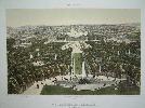
Imprint: Paris, c.1860
17 x 26.5 cms., early wash colour
A nice birds eye view of the gardens and palace of Versailles
Stock number:3268.
|
|
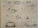
Imprint: Amsterdam, 1666
Edition: First Edition 430 x 530 mm., early outline colour, even light toning not offensive, in good condition.
This is a rare and desirable sea chart of the Canary Islands. It shows La Palma, Gomera, Tenerife, Gran Canaria, Forteventura and Lanzarote. An inset upper right features the harbour of Lanzerote. It was published in the first edition of Pieter Goos Zee-Atlas, a highly influential and regarded work. Koeman (1967-70) IV Goos IB no. 22; Phillips (1909-) 5690-22.
Stock number:5975.
|
|
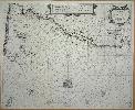
Imprint: Amsterdam, c.1650
430 x 530 mm., centre fold split, excellent restored. Fine condition, dark impression, with decent margins all the way around.
A very fine sea chart of the coasts of Brittany with dark engraving by Pieter Goos. Orientated with south at the top it displays prominently the Channel Islands. The French coastline from the Cherbourg Peninsula to Brest is also depicted. These treacherous waters are amply illustrated with anchorages, reefs and harbours. Englands Portland Bill is in the lower left. This chart lacks any imprint and as other Dutch sea charts of the period are very similar identifying it can be problematic. By comparing images of known maps I have I can rule out it being by Jansson or Lootsman. This leaves Pieter Goos or Theunisz Jacobsz. Jacobsz published the Lichtende Columne, ofte Zee-Spiegel in 1644; Goos published his version in 1652. The collations of both first editions in Koeman give the charts pagination 37; our chart is numbered 38. Koeman records that for the 1669 English edition the pagination was altered to 38 and the assumption is therefore that this is our example. The main area of difference on the map between the versions appears to be the nomenclature of Portland Bill. Koeman (1967-70) Goos 17 no. 43 & Goos 35 see note at the end.
Stock number:3967.
|
|
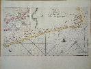
Imprint: Amsterdam, c.1666
295 x 530 mm., recent outline colour, small lower centrefold split, repaired, well away from the image as there are very large margins top and bottom, otherwise in good condition.
A rare early sea chart of the south western coastline of Africa extending from the Cape of Good Hope to Cabo Negro at 16 degrees south of the equator. This beautifully engraved chart displays critical waters in the Dutch East India Companies trade with the East Indies where all its vessels had to pass through. The map is derived from one by Jodocus Hondius which appears in a very rare pamphlet published in 1652. It described South Africa when Jan Van Riebeeck (1619-77) landed in Table Bay. Norwich described the chart as a fine, decisive copperplate engraved map with a great deal of detail of the coastline. There are two insets of which the smaller depicts Vlees Bay to the east of the Cape. The larger provides a detailed map and chart of the Cape of Good Hope including Table Mountain. Two ships adorn the sea with a compass rose orientating the map with north to the left. It was published in the Zee-Atlas one of the finest Dutch sea atlases of the time. Goos marine charts were held in high esteem in the seventeenth century. Koeman (1967-70) IV Goos 1B no. 24; Norwich (1983) 243.
Stock number:5382.
|
|
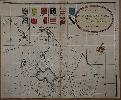
Imprint: London, 1731
495 x 595 mm., in early outline colour, with a couple of small holes along the centrefold all professionally restored, otherwise in good condition.
This is one sheet only from the first large scale map of the county of Huntingdon. The only other issued in the eighteenth century was by Thomas Jefferys in 1768. Gordon's map in 6 sheets is one of only a dozen produced in the eighteenth century on the very large scale of 2 inches to the mile. Indeed it is one of the very first multi-sheet map of any English county ever published. Engraved by Emanuel Bowen this sheet includes the title with Bowen's imprint beneath. It depicts the region south of Peterborough displayed beneath the coats of arms. It includes Woodstone, Atanground, Fletton, Overton Longville, Farcet, Yaxley and Whittlesey. Rodgers 196.
Stock number:7440.
|
|
|
Imprint: London, Chapman & Hall, 186, Strand, 1833
Binding: Hardback Inscription: Signed, Inscribed Or Annotated Octavo, three volumes (215 x 135 mm. each), contemporary half calf, marbled paper boards, blind ruled, spine with raised bands each gilt ruled, ornate blind diced compartment, gilt calf title and volume labels to each, upper board and spine detached from volume 3. With typographic half title and title to each volume, Preface, Population Return, List of Maps, pp. xx, (2), 110, (4), 760; (4), 876; (4), 875, (3), 20, 45, (1), 88, with 54 double page maps by Sidney Hall, some with light print offset, early outline colour, some minor offsetting, otherwise a good example.
Sidney Hall (1788?-1831) began his career as an engraver for the Arrowsmith family. Hall was a prolific engraver of the period and according to Worms and Baynton-Williams 'was almost certainly the first engraver to use the new harder steel plates for map work, using plates manufactured by the Jacob Perkins process as early as 1821'. His first county maps were those published by Samuel Leigh in 1820 in Leighâs New Picture of England and Wales, a miniature county atlas which proved a success. This series of maps was engraved for John Gorton's Topographical Dictionary issued in parts from 1831-32 and published by Chapman and Hall. There is no known familial link between the two Hall's. We cannot conclude for sure that Sidney Hall engraved all of the plates, as his will was proved 26 March 1831. The dates on the maps vary between 1830 and 1832. His widow Selina Hall was also an engraver and as she signed hers 'S. Hall', it is difficult to tell. The maps are bound alphabetically with those of Yorkshire, Ireland, Scotland and Wales consisting of two plates. A further general map of Inland Navigation is bound alphabetically. Population statistics are given from the Census for 1831. Provenance: Sir Willm. Bowyer Smyth, Bart. (1814-83), English cricketer and MP; Sotheby's sale of Shadwell Park, Thetford, Norfolk, 22 October 1992; private English collection. Carroll (1996) 94; Chubb (1927) 451; Worms & Baynton-Williams (2011).
Stock number:10280.
|
|
Imprint: London, T. Payne and Son, and J. Nichols, 1780
Binding: Hardback Quarto, 2 volumes (275 x 215 mm. each), full contemporary calf, ornate gilt ruled boards, rebacked preserving original spine, ribbed with gilt ruled compartments, each with ornate central gilt feature, gilt calf title and volume labels, title pages with engraved vignettes, pp. lii, 792, [57]; 822, [59], with 9 folding maps and plans, with light water stain along the spine of the first ten leaves, otherwise in good condition.
The eighteenth century topographer Richard Gough (1735-1809) once owned the map now famously named after him residing in the Bodleian Library. He was Director of the Society of Antiquaries from 1771-97 and bequeathed much of his private collection of medieval material to the Bodleian. This work is a compendium of British maps and topographical material known at the time. Sir John Cullum of Hardwick House wrote to Gough in 1782 stating that 'next to the Bible' his text was the work he most consulted. 'Map collectors at least should recognize 'British Topography' as the first comprehensive inventory of British maps and associated topographical literature. There has not been a work of comparable scope in the 200 years since it was written and although it may be dated it has not been replaced' (Walters). Provenance: private collection of Rodney Shirley. Shirley (1991) pp. vi-viii; Walters (1978) 'Richard Gough's Map Collecting for the 'British Topography'', in the 'Map Collector' no. 2 pp. 26-8.
Stock number:9409.
|
|