|
|
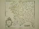
Imprint: Paris, 1751
485 x 520 mm., early outline colour. Large margins, fine condition.
With an attractive baroque cartouche housing the title. Pedley 321.
Stock number:4616.
|
|
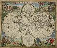
Imprint: Amsterdam, c.1670
480 x 570 mm., in fine early wash colour, remnants of mounting tape to the verso, otherwise in good condition.
De Wits map is one of the most attractive of its time (Shirley). Accurate dating of the publication of Frederick de Wits double-hemisphere world map is not possible as his atlases are undated and we have no further concrete knowledge. Shirley suggests that based on the cartographic depictions of Hudsons Bay that this map might even pre-date his maritime world map of 1668. De Wit (1630-1706) was one of the most successful Dutch engravers and map publishers of the second half of the seventeenth century. He had already published three wall maps of the world by 1670, in twelve, four and eight sheets. This attractive double-hemisphere map is renowned for its decoration. It bears two polar projection insets top and bottom and the surrounds are filled with allegorical designs incorporating the four elements, four seasons and the signs of the zodiac. This second state bears cherubs in the cusps between the hemispheres. The map was included in the composite de Wit atlases of the period and can also be found in those of other rival Dutch publishers such as Nicolas Visscher, the heirs of Jansson. A good clean example of a classic Dutch piece of cartographic art which was much copied by later cartographers. Provenance: private English collection since 1985. Koeman (1967-70) Wit 1; Shirley (1984) 451 st. 2.
Stock number:6213.
|
|
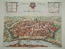
Imprint: Amsterdam, c.1695
390 x 500 mm. Magnificent early wash coloured copperplate engraving.
A very attractive birds-eye view of the city of Vienna bu Frederick de Wit with his imprint lower right. It was published in his Theatrum Praecipuarum Totius Europae Urbium and is the second state of a plate first issued by Johannes Janssonius in 1657. Koeman (1967-70) Wit 28, no. 52 p. 210; Van der Krogt (2007) Dits t oogh van Oostenrijck, het trots en machtich Weenen in Mappae Antiquae Liber Amicorum Gunter Schilder pp. 51-102 no. II 2.2.
Stock number:2881.
|
|
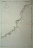
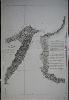
Imprint: Paris, 1860
930 x 645 mm., in good condition.
A fine detailed chart of the Italian Riviera extending from just south of present day Imperia (Porto Maurizio and Oneglia) in the south to Loano in the north.
Stock number:5135.
|
|
Imprint: Paris, 1864
625 x 925 mm., in good condtion.
A fine sea chart of the waters of Italy between Rome and Sardinia and Corsica. It extends on the mainland from Elba to Naples including Citta Vecchia and Rome.
Stock number:5141.
|
|
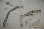
Imprint: Paris, 1860
630 x 955 mm., in fine condition.
This fine chart of the coast extends from Monaco in the west, eastwards through Menton, Ventimiglia and San Remo in the Italian Riviera. It is fascinating and sad to see how few buildings there were at the time.
Stock number:4365.
|
|
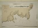
Imprint: Paris, c.1855
900 x 600 mm., in good condition.
An untitled chart of the waters approaching Dubrovnick. The town of Zaton on the right is just to the north of the city.
Stock number:5368.
|
|
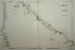
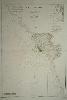
Imprint: Paris, 1861
730 x 440 mm., in good condition.
This represents the island of Birim which is off the south west corner of the Arabian peninsula in Yemen, just west of Aden.
Stock number:5512.
|
|
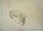
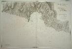
Imprint: Paris, 1868
305 x 470 mm., in very good condition.
A fine large scale plan of the harbour of Porto Praya (Praia) on Santiago, the capital of the Cape Verde Islands. It is situated on the south coast and shows wonderfully how the town has grown; the whole area to the south and west of the town is now developed. A prospect of the approach is shown above. The roads and individual buildings are shown, as are numerous soundings in the Bay. The original survey in 1834 is the work of Lieutenant William Arlett of the British Royal Navy who is duly credited in the title.
Stock number:6279.
|
|
Imprint: Paris, 1853
99 x 63.5 cms., with some light offsetting and a small repaired tear lower left otherwise in fine condtion
A fine detailed chart of Civitavecchia, Italy, the major port for entry to the capital Rome.
Stock number:4334.
|
|
Imprint: Paris, 1857
91.5 x 61 cms., with some light offsetting otherwise in fine condition
A magnificent chart of the harbour of Genoa, Italy. The topographical detail given is remarkable with buildings, roads and individual fields clearly marked.
Stock number:4341.
|
|
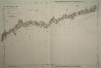
Imprint: Paris, 1864
930 x 630 mm., in good condition.
A fine large scale sea chart of the Straits of Messina between Sicily and the mainland of Italy. The town of Messina itself is at the centre of the chart with Reggio depicted on the opposite shore to the south east. To the right an explanation is given of the currents and navigation through the famous Strait.
Stock number:7200.
|
|
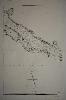
Imprint: Paris, 1862
640 x 920 mm., in good condition.
A superb large scale sea chart of the Straits of Messina between Sicily and the mainland of Italy. The town of Messina itself is shown in some detail lower left.
Stock number:7201.
|
|
|
Imprint: Paris, Chez Étienne Ledoux, Libraire, Rue Guénégaud, No. 9, 1824
Edition: First Edition Binding: Hardback Duodecimo, six volumes (160 x 110 mm. each), contemporary quarter calf, marbled boards, spines with raised bands, gilt calf titles and volume numbers, light wear to spine head and tails, retaining contemporary silk page marks. With typographic half title and title page to each volume, pp. (4), viii, 272; (4), 288; (4), 268; (4), 226; (4), 226, (2); (4), 268, with 58 early outline coloured maps (1 folding), 19 aquatint plates and three further engravings, otherwise in good condition.
This series of miniature maps were drawn it is believed by Aristide Michel Perrot (1793-1879). They accompanied a topographical description of Great Britain by George Bernard Depping (1784-1853). He was a naturalised Frenchman who was born in Münster, Germany in 1784. He became a professor of German and a member of the French Royal Society of Antiquaries. Perrot was a geographer who produced several works related to this field. The maps appear to be the work of the Parisian engraver Adrien Migneret (1786-1840). Each is adorned with what appears to be unrelated imagery. A very nice example of the first edition. Provenance: Clive A. Burden Ltd. 2011; private English collection. Carroll (1996) no. 83; not in Chubb; Tooley (1999-2004).
Stock number:9923.
|
|
|
Imprint: Paris, Chez Étienne Ledoux, Libraire, Rue Guénégaud, No. 9, 1824
Edition: First Edition Duodecimo, six volumes (150 x 90 mm. each), full contemporary mottled calf, ornate gilt panelling, spines with gilt ruled bands, gilt calf titles and volume numbers, marbled endpapers, retaining contemporary silk page marks, light wear. With typographic half title and title page, pp. (4), viii, 272; (2), 288; (4), 268; (4), 226; (4), 226, (2); (2), 268, with 58 early outline coloured maps (1 folding), 15 aquatint plates and three further engravings, otherwise in good condition.
This is the first edition of one of the very few British county atlases not published in the British Isles. It is believed that the series of miniature maps were drawn by Aristide Michel Perrot (1793-1879). Perrot was a geographer who produced several works related to this field. They accompanied a topographical description of Great Britain by George Bernard Depping (1784-1853). He was a naturalised Frenchman who was born in Münster, Germany in 1784. He became a professor of German and a member of the French Royal Society of Antiquaries. The maps appear to be the work of the Parisian engraver Adrien Migneret (1786-1840). The maps are set within a border of produce and topography reputedly related to the area. The maps themselves are quite small and bear little detail. They have volume and page numbers which are at sufficient distance from the main image that they are often trimmed in binding. Each is accompanied by several pages of descriptive text. Ten maps also bear the name Thierry. They were brothers who were also engravers in Paris specialising in maps. It appears that more than one engraver was involved. The binding order is unusual in that it commences with Wales and extends through Scotland and Ireland in the first three volumes. The final three describe England. This is likely a reflection of French leanings towards the Celtic regions. Similarly, only 19 maps illustrate English counties, 6 on Wales, 15 on Scotland and 19 on Ireland. Provenance: inscription on front free endpaper of James W. Shaw MD 9 June 1973; Dominic Winter auction 13 April 2006 lot 147; private English collection. Carroll (1996) no. 83; not in Chubb (1927); Tooley (1999-2004).
Stock number:10267.
|
|
|
Imprint: Paris, Chez Étienne Ledoux, Libraire, Rue Guénégaud, No. 9, 1835
Binding: Hardback Duodecimo, four volumes only (150 x 100 mm. each), contemporary quarter calf, marbled paper boards, spines with gilt decoration largely worn away, gilt volume numbers, retaining contemporary silk page marks, worn. With typographic half title and title page to each volume, pp. (4), viii, 272; (4), 268; (4), 226; (4), 226, (2), with 39 (of 58) early outline coloured maps (1 folding), and c.14 aquatint plates, otherwise in good condition.
This is an incomplete example of an unrecorded edition of one of the very few British county atlases not published in the British Isles. It is believed that the series of miniature maps were drawn by Aristide Michel Perrot (1793-1879). Perrot was a geographer who produced several works related to this field. They accompanied a topographical description of Great Britain by George Bernard Depping (1784-1853). He was a naturalised Frenchman who was born in Münster, Germany in 1784. He became a professor of German and a member of the French Royal Society of Antiquaries. The maps appear to be the work of the Parisian engraver Adrien Migneret (1786-1840). The maps are set within a border of produce and topography reputedly related to the area. The maps themselves are quite small and bear little detail. They have volume and page numbers which are at sufficient distance from the main image that they are often trimmed in binding. Each is accompanied by several pages of descriptive text. Ten maps also bear the name Thierry. They were brothers who were also engravers in Paris specialising in maps. It appears that more than one engraver was involved. The binding order is unusual in that it commences with Wales and extends through Scotland and Ireland in the first three volumes. The final three describe England. This is likely a reflection of French leanings towards the Celtic regions. This example includes only volumes, 1, 3, 4 and 5. Provenance: private English collection. Carroll (1996) no. 83; not in Chubb (1927); Tooley (1999-2004).
Stock number:10268.
|
|

Imprint: London, 5 August 1775
705 x 1040 mm., in 2 sheets joined, large aquatint and etched engraving, UNFOLDED AND UNCUT, with the LVG watermark. With pamphlet, quarto (280 x 230 mm.), original blue wrappers, typographic title, pp. 5-(12), there are no pages 3-4 which agrees with the John Carter Brown example.
The FIRST STATE of one of the most important Revolutionary War illustrations of Boston and its approaches. Accompanied by the VERY RARE twelve page PAMPHLET by George Callender entitled Nautical remarks and observations for the chart of the harbour of Boston. Composed from different surveys; but principally from that taken in 1769. Callendar was the Master of His Majesty's Ship the Romney. Commissioned in 1762 she served extensively in North America arriving in Boston 17 May 1768 to support the British during the enforcement of the Townsend Acts. Short of men it was the pressing of local men into service which increased tension in the town to a level which broke out in the Boston Massacre of 1770.This chart is part of a very large body of work known as the Atlantic Neptune undertaken by Des Barres It is one of the greatest hydrographic achievements of the eighteenth century. The French and Indian War highlighted the lack of accurate mapping of the vast territories now under British control in North America. Samuel Holland was entrusted with the task of accurately mapping the northern portion of these territories. He proposed using the latest accurate methods which included astronomical readings and triangulation. In 1769 he personally was still working in Canadian waters but had instructed Callendar to undertake the survey of Boston. In England Des Barres was in charge of undertaking the detailed engraving. He set about providing the British government with more accurate mapping of the entire coastline of America and Canada. They proved to be of just as much use to the American Rebel forces. Their quality and accuracy are well known and deserved. This particular chart is notable for recording Boston as it was at the outbreak of hostilities. It illustrates the British defences before the siege. The second state in particular out of the four later ones would record the progress of the siege works constructed by the Americans around the city. As the title informs us it was surveyed in the year 1769, a troubled time in Boston. Extensive soundings are provided in the harbour with numerous points marked to ease navigation through difficult waters. What separates this chart out from most others is the level of topographical detail on land. The road structure is accurately recorded as are the local towns. It even goes as far as recorded field boundaries, a remarkable body of information for historians. The high quality engraving enables surface features to be displayed especially the elevation of the terrain. An alphabetical key upper right identifies fourteen locations in the immediate area of Boston, including batteries, docks, forts, wharves, and the all important Charles-town Ferry.The accompanying pamphlet of sailing directions is rare, it was replaced soon after by a single sheet version entitled 'A Chart of the Harbour of Boston, composed from different surveys ...' which is sometimes found pasted to later states of the map. Being separately issued it is rarely found with the chart as here. Provenance: Duke of Northumberland. Boston Engineering Department, List of Maps of Boston, pp. 70-71; Cumming, British Maps of Colonial America, pp.51-56; ESTC N12343 (pamphlet); Guthorn, British Maps of the American Revolution 59/3, Holland's original manuscript; Krieger and Cobb, Mapping Boston, p. 106, plate 19; Nebenzahl, Bibliography of printed battle plans, 3; Sabin 10061 (pamphlet); Sellers & Van Ee, 945; Stevens, Bibliography of the Atlantic Neptune (unpublished) pp. 211-216; Streeter, II:706.
Stock number:8314.
|
|
Imprint: Jena, 1831-48
Volume 9 only with 326 plates. Plate numbers 2274-2599.
This large periodical by Dietrich (1799-1888) was issued in parts. This volume with 326 plates includes images of Convulvulus, Stapelia, Morning Glory and Verbena. Great Flower Books p. 55; Nissen 486.
Stock number:1885.
|
|
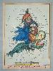
Imprint: London, c.1795
140 x 100 mm., early wash colour, in good condition.
This is a desirable caricature map of England and Wales after Robert Dighton (1752-1814), a well known eighteenth century painter of portraits and caricatures. Initially he often worked anonymously for Carington Bowles. In the 1790s his series of caricature portraits earned him praise. He achieved notoriety however when he took some Rembrandt engravings from the British Museum and replaced them with copies. They were all located in his rooms and returned. The date of issue is unknown but the first catalogue in which they appear is dated to 1795. They were so successful that the Bowles firm issued this reduced size in 1808. No specific reason has been identified for the depiction and they were merely intended for amusement. Feaver (1988) p. 60; Hill (1978) pp. 44-5; Mackenzie (1998) p. 143Worms & Baynton-Williams (2011).
Stock number:6987.
|
|
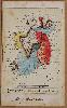
Imprint: London?, c.1870
Inscription: Signed, Inscribed Or Annotated 85 x 60 mm., each, laid on card, in printed colour, with remnants of paper to which they had been affixed on the verso, manuscript annotations on verso of all three signed 'LT'.
The England and Wales in this series was originally conceived by James Gillray and published by Hannah Humphrey in 1791, the accompanying Scotland and Ireland were designed by Robert Dighton in 1793 and published by Bowles and Carver. The initial quarto engravings were popular and soon followed by reductions in 1808. The England and Wales offered here bears at the bottom a general advertisement for the series. Below this in all three cards are manuscript notations stating 'Very Scarce & valuable', 'Very Scarce indeed', etc. This is the same hand as on the verso of each card which state 'These three cards Given to me by Mr George Crowther of Hebden Bridge 1916 L.T.' . One of the most famous cartographic caricaturist was only recently identified as Lillian Lancaster. As a girl she provided the drawings for William Harvey's 'Geographical Fun' who used the pseudonym Aleph. In his introduction he writes how the maps were drawn by a fifteen year old girl for the amusement of her sick brother, this was Lillian Lancaster. Born Eliza Jane Lancaster in 1852 in London she went on to the stage as a pantomime artist, comedy actress and singer. The idea apparently came from an earlier drawing of England represented by Punch riding on a dolphin. Their intent was not just entertainment but also educational as the introduction states no history no journal can be understood without acknowledge of maps, and good services is done when we make such information more easy and agreeable. In 1884 she married William Edward Tennant, a London tutor and landed proprietor. William died at the young age of 43 in 1897 and Lillian subsequently retired to Brighton, where she would seem to have returned to designing and producing humorous manuscript caricature maps. It is possibly no coincidence that her married initials became L.T. as inscribed here on these caricatures. Provenance: private English collection. Barron http://barronmaps.com/lilian-lancaster-1852-1939/; Slowther, Catherine The Map Collector no. 16 pp. 48-50; Worms & Baynton-Williams (2011).
Stock number:7039.
|
|