|
|
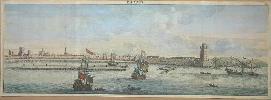
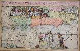
Imprint: Paris, 1714.
21 x 61 cms., in lovely early wash colour. Fine condition.
A fine panorama of Rhodes from Cornelis Le Bruyn's 'Voyage au Levant'. De Bruyn was a Dutch traveller and painter who spent the years 1678 to 1685 in the Levant. De Bruyn was primarily a landscape artist and this is manifested in the magnificent panoramas found in the book. This one of Rhodes is one of them. Blackmer 225; Cohen de Ricci 610; Nordenskiold Collection 3.358.
Stock number:3783.
|
|
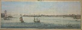
Imprint: Paris, 1714.
21 x 61 cms., in lovely early wash colour. Fine condition.
A fine panorama of Rhodes from Cornelis Le Bruyn's 'Voyage au Levant'. De Bruyn was a Dutch traveller and painter who spent the years 1678 to 1685 in the Levant. De Bruyn was primarily a landscape artist and this is manifested in the magnificent panoramas found in the book. This one of Rhodes is one of them. Blackmer 225; Cohen de Ricci 610; Nordenskiold Collection 3.358.
Stock number:3782.
|
|
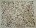
Imprint: Frankfurt, 1591
370 x 460 mm., with some professional repair to the double folds as usual, with good margins on three sides, the top cut close just affecting upper right where some facsimile of the neat line exists, otherwise in good condition.
A good example of Jacque Le Moynes iconic map of Florida originally published in the second volume of the Grand Voyages by Theodore de Bry. 'In 1562 one of the most influential Huguenots in France, Admiral Gaspard de Coligny, sent Jean Ribaut a highly talented navigator to Florida on the first voyage. He like the rest of the crew were of the same religious persuasion. They landed at the St. John's River and named it River May, F.Maij, because they arrived on the first of that month. They sailed north along the coast and upon reaching a large bay that they named Portus Regalis, they then proceeded to build a fort called Charlefort. This is the first mention on a printed map of Port Royal, unless one considers the Hondius-Le Clerc map of 1589 [1602]. Ribaut returned to France to bring further supplies, and left about thirty men to hold the fort. However, upon his return he found France was in the middle of a religious civil war. He took part in the struggle and then had to flee to England. Whilst there he became involved in a political plot and was imprisoned. In Florida, meanwhile there had been a mutiny and an attempt by the colonists to make it back to Europe. Building a small craft of their own they would have perished at sea had they not been picked up by an English ship in July 1563. In 1564, with the restoration of peace in France, Coligny sent out a second expedition. With Ribaut in prison he sent René de Laudonnière, who had been on the first voyage. Also present was Jacques le Moyne, sent to record and map as much as possible. This time they settled on the River May and built Carolina on the south bank. Laudonnière proved to be a poor leader and was soon replaced by the arrival of Ribaut who, released from prison, had been sent by Coligny to take control. Shortly after the Spanish, having heard of the French presence arrived to destroy the settlement and kill all the heretics'. Among the few survivors were Laudonnière and le Moyne. Having left in a hurry and spending a number of days in the swamp and forest, it is unlikely that any of le Moyne's original work survived with him. Le Moyne reached England where he must have proceeded to draw from his memory. He spent the rest of his life in London. De Bry travelled there about 1587 and tried to purchase these drawings, to no avail. The following year, however, le Moyne died and he bought them from his widow. The manuscript map (if there was one) has not survived and only one watercolour exists, that being in the New York Public Library.Despite the fact that this map was not very accurate its influence was considerable. This is mainly because Hondius used it for his map of the area in 1606, the atlas in which it occurred was Mercator's and his fame was enough to prolong its authority until the Blaeu VIRGINIÆ partis australis, c.1638. Latitudinally it was fairly accurate but as always it was the longitude that was incorrect. This led to a vastly extended eastward slant of the coastline. Most of the information on the map is derived from Indian sources and not French ones. Much of the nomenclature did not survive the arrival of the English, with the obvious exceptions of Port Royal and Prom. C naueral. The later colonies of Carolina were named after King Charles II of England, its presence here was purely coincidental. Several lakes are shown including what is thought to be a representation of the sea of Verrazzano, an apocryphal route through to Asia. However, with the nearby presence of a large waterfall, many believing it to represent Indian tales of Niagara Falls, it could in fact be the Great Lakes' (Burden).References: Alexander (1976) pp. 12-59 (illustrating most of the plates in the de Bry)/ Church (1907) nos. 145-7 & 179-80/ Cumming (1938) pp. 476-92/ Cumming (1962) no. 14, and pp. 12-13/ Cumming (1963) pp. 27-40 (a manuscript map contemporary with the period)/ Cumming, Skelton & Quinn (1972) pp. 154-71 & 181-92/ Faupel (1990) pp. 33-6/ Fite and Freeman (1926) pp. 68-70/ Garratt (1979) p. 5 G2/ Lorant (1946) pp. 4-119/ Lowery (1905?)/ Sabin (1868) no. 8784/ Schwartz and Ehrenberg (1980) pp. 64-7.
Stock number:8222.
|
|
|
Imprint: Frankfurt, 1599
Edition: First Edition 120 x 225 mm., in full wash colour, with repaired tear in lower right corner, not affecting the image, otherwise in good condition.
This is Theodore De Bry's reduction of Jodocus Hondius' broadside map illustrating the circumnavigation of Sir Francis Drake's in 1577-1580. It illustrates Drake's route using tiny ships along the route to denote the direction of travel. Around the map are a portrait of him at the top and illustration of his ship below. The map is further embellished with sea monsters and elegant strap work. The exact date of the original Hondius-Drake broadside is not known but believed to be the work of Jodocus Hondius, circa 1595. This particular map appeared in several editions of De Bry's 'America' Part VIII, beginning in 1599. The present example was the title page to the first edition in Latin, 1599. The work described three voyages by Sir Francis Drake, one by Henry Cavendish and two by Sir Walter Ralegh. As the Hondius broadside is virtually unobtainable, the present map is highly sought after among collectors. Church I 163 illustrated pl. 163; Shirley 219 and refer to 188.
Stock number:9411.
|
|
Imprint: Paris, 1729
450 x 570 mm., with fine recent wash colour, with folds as issued, in fine condition.
This plan of the modern Paris is from Nicholas de la Mare's 'Traite de la Police'. It includes eight plans of Paris from its foundation to the time of publication. This the eighth is the most modern of them.
Stock number:4582.
|
|
Imprint: Paris, 1705
Edition: First Edition 470 x 600 mm., early outline colour, in good condition.
A fine detailed map of south western Germany. Published in Nicolas de Fer's folio 'Atlas ou Recueil de Cartes Geographiques'. At first separately published it would appear in the first edition of 1709 and was engraved by C. Inselin. Pastoureau Fer II no. 55.
Stock number:5531.
|
|
Imprint: Paris, 1705
Edition: First Edition 575 x 425 mm., early outline colour. Light browning to the left of the centrefold otherwise fine.
This fine map of Portugal by Nicholas de Fer is engraved by P. Starckman. It was issued in the first edition of the "Atlas ou Recueil de Cartes Geographiques", 1709. Pastoureau De Fer II C no. 72.
Stock number:4614.
|
|
|
Imprint: Paris, 1705
Edition: First Edition 575 x 425 mm., early outline colour, in good condition.
This fine map of Portugal by Nicholas de Fer is engraved by P. Starckman. It was issued in the first edition of the "Atlas ou Recueil de Cartes Geographiques", 1709. Pastoureau De Fer II C no. 72.
Stock number:10370.
|
|
Imprint: Paris, 1705
59 x 47 cms., early outline colour. Some light foxing to the lower margin otherwise in fine condition
The map displays the region to the west of the lower Rhone river valley. It shows Beziers in the west and Arles at the mouth of the river. It extends north up the river to Tournon. It was published in De Fer's folio atlas entitled 'Atlas ou Recueil de Cartes Geographiques'. The atlas followed a quarto one and was first issued in 1709. With two attractive cartouches the map extends from Lyon in the south to Chatillon in the north. Pastoureau Fer II C no. 30
Stock number:4160.
|
|
Imprint: Paris, 1690
13.5 x 21cm. Uncoloured map with some age toneing.
Detailed plan of town and environs from this famous stretch of the Cote d'Azur.
Stock number:3079.
|
|
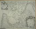
Imprint: Amsterdam, 1693
580 x 940 mm., two sheets joined, in fabulous early wash colour, royal coat of arms and cities heightened in gold, minor centrefold split just into the lower part of the image, otherwise in excellent condition.
In 1692 Pierre Mortier had published a Dutch contrefaçon of the 'Atlas Nouveau' by Alexis-Hubert Jaillot. It was issued in partnership with Pierre Huguetan, a French bookseller resident in Amsterdam, who provided considerable financial backing. Their next project was an edition of Jaillots 'Neptune François', first published in 1693. For this Mortier employed the finest engravers and extended the work with the magnificent 'Cartes Marines à lusage du Roy de la Grande Bretagne'. It contained only nine charts, eight of which were of British waters. They are engraved by Romain de Hooghe, who was in the employ of William III at the time, and are arguably the most stunning sea charts produced to date (Burden). Few great artists have turned their hands to mapmaking
Romeyn de Hooghe was an exception to the pattern. A celebrated artist from the late seventeenth century, he was responsible for a volume of nine sea charts (Campbell).This is one of only two plates that focus on the coasts of England; it extends from Kent in the east to Portland Bill in the west. The River Thames upriver to Kingston is clearly displayed. The map also extends southwards to take in the Channel Island of Alderney. A detailed inset centres on the Thames Estuary and an extremely ornate dedication cartouche to William III is flanked with fine views of Portsmouth and Rochester. It was issued just one year after the French planned invasion along the same coast. Burden (2007) p. 486; Campbell (1981) pl. 44; Koeman (1967-70) IV Mor E no. 7.
Stock number:8050.
|
|
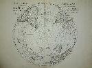
Imprint: Paris, 1714
48 x 52 cms. each, two maps, early outline colour
A pair of maps in their first state of the polar hemispheres. The northern displays California as a peninsula and a spartan northern Pacific. The south polar map depicts the routes of explorers including Tasman. These highlight one of the features that De L'Isle is most highly regarded for, that being to leave blank any area for which no knowledge was known. Earlier cartographers were wont to insert guesswork coastlines and topographical features. From the 'Atlas Nouveau'. Good impressions. Clancy 6.26; Tooley Australia no. 1512; Wagner (NW) no. 504
Stock number:3205.
|
|
Imprint: Paris, 1702
47 x 61 cm Decorative map in original outline colour, with a lovely cartouche. Some minor repairs to tears in the borders, not effecting the image. One small fox mark top right, and an ink mark lower left.
The EXTREMELY RARE FIRST STATE with the Rue des Canettes imprint. It is separately published before De LIsle began issuing regular atlases. This is the true first state before the addition of Harwich, it was the third state before the imprint was altered. It fully reflects the high standard of his work ... the map is a fine example of polished engraving, restrained decoration and pleasing balance. Shirley, R.W. (BI 1650-1750) Delisle 1, state 1.
Stock number:3345.
|
|
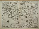
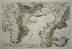
Imprint: Antwerp, 1578-[93]
Edition: First Edition 380 x 510 mm., a good impression in fine condition.
This map beautifully engraved by Jons van Deutecum is one of those which first appeared in 1578. It depicts the eastern Mediterranean Sea with special emphasis on Greece and Asia Minor. It includes also the islands of Cyprus and Crete. It is however unclear as to its exact origins. The closest we have been able to find is unsigned and survives in just three known examples most famously in the Doria Lafreri atlas. It is only identified by the imprint of Venice 1570 and is listed in Tooley as no. 37. Its coverage is slightly further west than De Jodes map extending half way up the Italian peninsula. This map is decorated with three ships in the Mediterranean and one (Noahs Ark) on top of Mount Ararat! There are two separate titles indicating that it may also have been compiled from two earlier maps. The map takes on special significance when you bear in mind that through much of the middle sixteenth century the Ottoman Empire was at war with Venice.Gerard de Jode (1509-91) was born in Nijmegen but started his career in Antwerp as a printer and engraver. He also bought and sold maps and was a frequent attendee at the Frankfurt book fair. Many of the maps he acquired formed the basis for his Speculum Orbis Terrarum of 1578. He was up against the competition of Abraham Ortelius Theatrum Orbis Terrarum which had an 8 year advantage on him. Despite the fact that De Jode was 18 years his senior and that in 1564 he had published the Ortelius world map in 8 sheets their relationship turned sour. Ortelius used his influential contacts and more aggressive marketing to promote his own work and delay that of de Jode. Correspondence survives indicating de Jodes application for a licence was rejected, probably until that of Ortelius expired. The first edition is of great rarity. Gerard de Jode died in 1591 and the business was carried on by his widow and his son, Cornelis. He was more of a publisher than an engraver but it was enough for his revised and enlarged second edition to prove more popular. Koeman (1967-70) Jod 2 no. 16; Van der Krogt (1997-2003) 8100:32; Meurer (2004) no. 94; Tooley Lafreri maps, in Imago Mundi no. 3; Zacharakis (1992) no. 1164.
Stock number:6344.
|
|
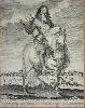
Imprint: Amsterdam, c.1660
510 x 410 mm., trimmed just into the image, with a tear running across the upper part of the engraving, professionally repaired, some other very minor restoration otherwise in good condition.
This appears to be only the SECOND KNOWN EXAMPLE of the FIRST STATE of Clement de Jonghe's portrait of Charles II. The only recorded example according to Layard is at the Sutherland Clarendon Collection at the Bodleian Library, Oxford. The engraving is an equestrian portrait of Charles II in armour with a view across the Thames to London in the distance. The print was engraved to celebrate the Restoration of Charles to the throne in 1660. The image of London in the background records the old St. Paul's Cathedral before its destruction in the Great Fire of London in 1666. It is derived from the panorama of Matthias Merian published in Frankfurt, 1638. At the bottom is a celebratory verse in four languages, the far right being English:Behold the greatest King that ever England sawNot onely born to reigne, and cald by human Law;But raised, as it were, from death: that all maight seeHis Throne a saiths reward & heavnlij Gist to beeThe British Museum Department of Prints and Drawings possess an example of a later state depicting George I dated to 1714 (Sligo Collection 1935,0413.181). The title is altered to "Georgius Ius D.G. Magn. Britann. Franc. et Hib. Rex" and the head and parts of the sky are re-engraved. For that issue there also appears to be much retouching of the engraving across the plate. Layard, George Somes, 'Catalogue Raisonné of Engraved British Portraits from Altered Plates', London, 1927. No. 25.I; Thieme & Becker (1907-50) XIX 134.
Stock number:6466.
|
|
Imprint: Leiden, 1630
275 x 350 mm., one small faint foxmark upper left near the border, otherwise in good condition.
This is one of three maps that relate to the east coast of North America in Joannes de Laet's work. "This is arguably the finest description of the Americas published in the seventeenth century. Despite the fact that he drew on a large number of sources for his information, no fresh material on the area had been forthcoming for decades. Hessel Gerritsz, the author and probable engraver of the map, drew therefore on the interpretation by Claesz, c.1602, of the Jacques le Moyne cartography of Florida. Originally thought to be taken from Jodocus Hondius' map of Virginia and Florida, 1606, this study demonstrates otherwise. One notable area of alteration is the placing of C. Francois further east into the Atlantic Ocean. Florida, as we know it today, is here called 'Tegesta provinc'. This name, applied here for the first time, is that of a tribe of Indians living on the south-west coast. 'Florida' was at this time applied to a far larger region. It came to be used solely for the peninsula as Spanish Florida was squeezed south by the expansion of the English colonies.For the rest of the map he drew upon the nomenclature of the Ortelius-Chaves map of 1584. The river delta system, however, is still confusing. The 'Bahia del Spiritu Santo' is often thought to refer to the mouth of the Mississippi River. Studies have questioned the assumption of this attribution. The map's influence was quite considerable. Blaeu, Janssonius and Sanson, all followed it. There were subsequent editions in Latin, 1633, and French, 1640. In all of these there is no text on the reverse (Burden).""Considerable effort went into making the text and maps of this work the most accurate available at the time. It is arguably the finest description of the Americas published in the seventeenth century. The exhaustive research involved de Laet reading all of the published and manuscript material that he could find. For the cartographic work he had much to call on, being a director of the recently formed Dutch West India Company in charge of all Dutch interests in America and Africa. He therefore had access to the latest geographic knowledge. He also drew upon the fine talents of Hessel Gerritsz, the official cartographer to the Dutch East India Company since 1617. This was a post he attained before Willem Blaeu under whom he was apprenticed, and who was his senior by ten years. The maps were some of the first to depart from the heavier style of the Mercator and Ortelius period (Burden)." From the 'Nieuwe Wereldt ofte Beschrijvinghe van West-Indien
' Burden 232; Cumming (1962) no. 34, pp. 5 & 17-18.
Stock number:6044.
|
|
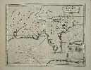
Imprint: London, 1745-[?]
625 x 795 mm., with horizontal fold near the bottom placed at some time to allow binding in a book. Some light repair to double fold as to be expected, a 100 mm. repaired tear, just to the left of the lower centrefold, the top and right folds with small repaired tear, otherwise in good condition.
This is a rare, important plan of Chester and one of the earliest large scale plans of the city. It is one of many published in the middle of the eighteenth century which importantly record cities before rapid industrialisation. The copper-engraved plan is by the surveyor Alexander De Lavaux about who little is known other than his self styled description as an Engineer. The engraving is attributed to Richard Parr (fl.1723-51) who worked especially closely with John Rocque the great publisher of many large scale maps. Quite how that is known we have been unable to find out as his imprint does not appear on the map. The plan displays clearly how the city had already grown beyond its ancient walls. It is shown before the construction of the Chester Canal in 1779. The detail is remarkable with notable town residents buildings being identified as are all of the roads including even the Maypole on Northgate Street. Each individual field is laid out according to its usage. To the left of the map the River Dee takes an apparent unnatural course which is entirely man-made. During the eighteenth century Chesters trade had diminished considerably thanks to the gradual decrease in the navigability of the river. Using engineers from the Netherlands an artificial channel was excavated 1732-36. It was paid for by local merchants and the Chester Corporation. This is an interesting example and apparently an UNRECORDED STATE because it looks like it was pulled from a plate with trimmed left and right edges. A heavy plate-mark can clearly be seen suggesting that possibly due to wear or damage the copper was trimmed to make it usable again. No neatline was introduced so we have the appearance of missing sheets. Comparison with an example of the first state indicates that about 15 mm. on the left and some 95 mm. on the right have been trimmed. When this example was printed cannot be determined but the paper can clearly be identified as eighteenth century as it bears chain lines and a water mark IV. Provenance: private American collection. Refer Tooley, Cheshire in The Map Collector no. 17 p. 25 Ch44.
Stock number:5981.
|
|
Imprint: Paris, 1753
510 x 630 mm., in early outline colour.
The first state of a finely engraved large scale map of Luxembourg published in the "Atlas Universal". Mickwitz, A. II,245; Pedley 225 Van der Vekene 3.28A.
Stock number:4679.
|
|
|
Imprint: Paris, 1772
320 x 375 mm., in good condition.
An unusual map of the northern and eastern coastline of Russia, Scandinavia and Japan. It also shows a portion of the north west of the American continent called Anian. Four insets display maps of the western part of North America. The first shows the entire western coast with Japan just offshore. The second centres on Nova Granada and the Gulf of California. The third shows the Zubgara and Tolm Regnum of North America extending south to the mythical seven cities of Cibola. The last shows Anian Regnum and Quivira Regnum, a more detailed examination of the west coast. From the 'Supplement' to Denis Diderot's 'Encyclopedie'. Pedley, M.S. #406.
Stock number:5192.
|
|
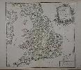
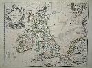
Imprint: Paris, 1753
475 x 515 mm., in early outline colour, in good condition.
An attractive map of England and Wales including the east coast of Ireland. It was published in Robert de Vaugondy's 'Atlas Universel'. There are two variants of this map refering to either 'Belfart' or 'Belfast'. It may be presumed that this 'Belfart' issue is the first. Pedley 48, state 1.
Stock number:7433.
|
|