|
|
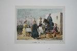
Imprint: Paris, 1841
230 x 280 mm., early coloured lithograph with large margins in good condition.
A fine view of a market scene in Lima, Peru, fom the 'Atlas Pittoresque' by Abel du Petit-Thouars's which illustrated the 'Voyage Autour du Monde sur la Fregate Venus' published in Paris, 1841. The French in the nineteenth century undertook a number of scientifically orientated voyages of discovery in the Pacific Ocean. Ferguson (1941-69) no. 2970; Hill (1974) p. 91.
Stock number:7868.
|
|
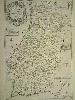
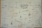
Imprint: Paris, c.1680
695 x 470 mm., early outline colour. In fine condition.
A lovely large map of Portugal published by the widow of Pierre Du Val. Not in Pastoureau or any Portuguese references.
Stock number:4613.
|
|
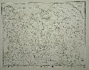
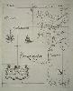
Imprint: Paris, 1677
400 x 505 mm., early outline colour, in good condition.
A rare map by Pierre Duval first published in the 'Cartes Geographiques' in 1654. Here we have the second state in which the date 1677 has been added below the Privilege. Pastoureau Duval IIA no. 10 & IID.
Stock number:4923.
|
|
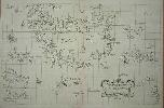
Imprint: Florence, 1646-[61]
48 x 75 cms. In excellent condition
One of the great sea charts in Dudley's 'Arcano del Mare'. It is the first printed English nautical atlas. It was superior to any previous work in that the charts illustrated the whole world, the first time any outside of Europe had been included. It was the first atlas to use Mercator's projection throughout, and the earliest to show the prevailing winds, currents and magnetic deviation. Dudley improved upon the theory of navigating by the Great Circle', the shortest distance between two points on a globe. It would be the eighteenth century before cartographers used the projection consistently. During the great Dutch period not one atlas was produced using it. This chart of Iceland includes to the south west the fictitious island of Frisland, to the south east lie the Faroe Islands. Iceland itself bears a wonderful volcano spouting lava. The chart is copies from a Dutch model, as it says on the chart itself, and the source is the map by Joris Carolus. Shirley BL Atlases M.Dud-1a no. 69.
Stock number:3710.
|
|
Imprint: Florence, 1646-[61]
470 x 380 mm., with slight fold flattened, otherwise in very good condition.
A fine sea chart of the coast of Portugal from Syntra to Figemonte in the Algarve. The harbour of Lisbon is featured in some detail with extensive notations of depths. The whole is decorated with an ornate title cartouche, a compass rose and a ship. The map was published in Sir Robert Dudleys magnificent Arcano del Mare. Lord Wardington wrote that it is ONE OF THE GREATEST ATLASES OF THE WORLD and one of the most complex ever produced: it is the first sea-atlas of the whole world; the first with all the charts constructed using Mercators new projection, as corrected by Edward Wright; the first to give magnetic declination; the first to give prevailing winds and currents; later to be further expanded by Maury and J.T. Towson in the nineteenth century; the first to expound the advantages of Great Circle Sailing; and the first sea-atlas to be compiled by an Englishman, albeit abroad in Italy (Lord Wardington, Sir Robert Dudley, in The Book Collector, I 52 (2003). Not in Cartografia Impressa dos Seculos XVI e XVII Imagens de Portugal ... Exhibition Catalogue; Conde (2003) p. 189; Shirley (2004) M.Dud-1a 36.
Stock number:3912.
|
|
Imprint: Florence, 1648-[61]
47 x 37 cms., in excellent condition.
One of the great sea charts in Dudley's 'Arcano del Mare'. It is the first printed English nautical atlas. It was superior to any previous work in that the charts illustrated the whole world, the first time any outside of Europe had been included. It was the first atlas to use Mercator's projection throughout, and the earliest to show the prevailing winds, currents and magnetic deviation. Dudley improved upon the theory of navigating by the Great Circle', the shortest distance between two points on a globe. It would be the eighteenth century before cartographers used the projection consistently. During the great Dutch period not one atlas was produced using it. This chart of part of the Azores takes in the island of Corvo and a fictitious uninhabited island nearby. 'Olhar o Mundo ler o Territorio' Exhibition Catalogue p. 208; Shirley BL Atlases M.Dud-1a no. 47.
Stock number:4380.
|
|
Imprint: Florence, 1648
480 x 750 mm., in good condition.
This sea chart displays the west coast of Africa along with the islands of St. Helena & Ascension. It is in the rarer FIRST STATE from 1648. It appeared in Sir Robert Dudleys Arcano del Mare, the first printed English nautical atlas. It was superior to any previous work in that the charts illustrated the whole world, the first time any outside of Europe had been included. It was the first atlas to use Mercators projection throughout, and the earliest to show the prevailing winds, currents and magnetic deviation. Dudley improved upon the theory of navigating by the Great Circle, the shortest distance between two points on a globe. It would be the eighteenth century before cartographers used the projection consistently. During the great Dutch period not one atlas was produced using it. This chart of part of the Azores takes in the island of Corvo and a fictitious uninhabited island nearby. Shirley (2004) Atlases M.Dud-1a no. 82.
Stock number:5833.
|
|
Imprint: Florence, 1648
Edition: First Edition 475 x 365 mm., with light backing to area of fold created when on the drying rack, otherwise in very good condition.
This magnificent chart in its FIRST STATE is of much of the east coast of England and from the first edition of Sir Robert Dudley's landmark 'Arcano del Mare' published in Florence, 1646-48. Lord Wardington wrote that it is "ONE OF THE GREATEST ATLASES OF THE WORLD and one of the most complex ever produced: it is the first sea-atlas of the whole world; the first with all the charts constructed using Mercator's new projection, as corrected by Edward Wright; the first to give magnetic declination; the first to give prevailing winds and currents; later to be further expanded by Maury and J.T. Towson in the nineteenth century; the first to expound the advantages of 'Great Circle Sailing'; and the first sea-atlas to be compiled by an Englishman, albeit abroad in Italy" (Lord Wardington). The chart extends from Orford in Suffolk to Flamborough Head in Yorkshire. Dilke 'Sir Robert Dudley's Contributions to Cartography', in 'The Map Collector' no. 19 pp. 10-14; Shirley BL Atlases M.Dud-1a no. 69; Wardington, Sir Robert Dudley, The Book Collector, 52 (2003).
Stock number:8767.
|
|
|
Imprint: London, L. Tallis, 3 Jewin Street, City, c.1846
Binding: Hardback Quarto, five volumes (215 x 135 mm. each), contemporary half calf, marbled paper boards, gilt ruled, spines with gilt decorated raised bands, ornate blind panelled compartments, calf gilt title and volume labels, light wear. With 58 steel engraved maps consisting of 2 general, 43 English county maps (Yorkshire divided into 4), Isle of Wight and 12 Welsh counties and c.200 steel engraved plates, pp. 1586, iv, 144, light foxing and offsetting, otherwise in good condition.
Thomas Dugdale was an antiquarian and responsible for this the Curiosities of Great Britain. The work was issued with two distinct sets of maps. The first utilised those maps from the George Cole and John Roper British Atlas of 1810. This second series used a new set of maps engraved by Joshua Archer (1792-1863) which were derived from those of Cole and Roper. The publishers J. & F. Tallis had acquired the Cole and Roper plates and the Dugdale text by c.1835. They continued to issue the text with the maps and then offered this new series of plates concurrently. The work was completed by 1841, page 1580 refers to an event in February 1841. Examples are found bound in anything up to eleven volumes. The fact that the pagination is contiguous though the work enables such variation. All examples lack a date of publication and must be dated from internal evidence on the plates. This one is an early issue based on the fact that the Dugdale imprints are still present. The publisher is Lucinda Tallis, widow of John Tallis who operated from 3 Jewin Street between 1842 and 1846. It is bound with as usual, Leonard Townsend's Alphabetical Chronology. Beresiner (1983) pp. 46-7; Carroll (1996) 112; Worms & Baynton-Williams (2011).
Stock number:10306.
|
|
|
Imprint: London, Tallis & Co., Green Arbour Court, Old Bailey, 1835
Binding: Hardback Quarto (215 x 135 mm. each), three volumes, contemporary half calf, marbled paper boards, blind ruled, spine with raised bands with ornate gilt decoration, compartments with ornate blind decoration, gilt calf title and volume numbers, light wear. With 59 early outline coloured steel engraved maps and 36 steel engraved prints, some light foxing, some maps with light print offset, otherwise in good condition.
Thomas Dugdale was an antiquarian and responsible for this, the Curiosities of Great Britain. The work was issued with two distinct sets of maps. The first utilised those maps from the George Cole and John Roper British Atlas of 1810 as here. The second series used a new set of maps engraved by Joshua Archer (1792-1863). The publishers J. & F. Tallis had acquired the Cole and Roper plates and the Dugdale text by c.1835. Provenance: private English collection. Beresiner (1983) pp. 88-90; Carroll (1996) no. 62; Chubb (1927) 465.
Stock number:10233.
|
|
|
Imprint: London, 1835
Binding: Hardback Quarto (220 x 140 mm. each), ten volumes, contemporary green cloth, boards with ornate blind decoration, spines with blind and gilt panelling, gilt titles. With 56 early hand coloured steel engraved maps and purportedly 11 plans and 238 views, some light foxing, some maps with light print offset, otherwise in good condition.
Thomas Dugdale was an antiquarian and responsible for this the Curiosities of Great Britain. The work was issued with two distinct sets of maps. The first utilised those maps from the George Cole and John Roper British Atlas of 1810. This second series used a new set of maps engraved by Joshua Archer (1792-1863) which were derived from those of Cole and Roper. The publishers J. & F. Tallis had acquired the Cole and Roper plates and the Dugdale text by c.1835. In 1835 the plates were used to accompany Thomas Dugdaleâs Curiosities of Great Britain. Provenance: private English collection. Beresiner (1983) pp. 88-90; Carroll (1996) no. 62; Chubb (1927) 465.
Stock number:10234.
|
|
|
Imprint: London, c.1850
Binding: Hardback Quarto, three volumes (215 x 135 mm.), contemporary half calf, cloth boards, blind ruled, very decorative gilt spines with titles. With 58 steel engraved maps consisting of 2 general, 43 English county maps (Yorkshire divided into 4), Isle of Wight and 12 Welsh counties, all in early outline colour and c.200 steel engraved plates, pp. 1586, iv, 140, light foxing and offsetting, otherwise in good condition.
Thomas Dugdale was an antiquarian and responsible for this the 'Curiosities of Great Britain'. The work was issued with two distinct sets of maps. The first utilised those maps from the George Cole and John Roper 'British Atlas' of 1810. This second series used a new set of maps engraved by Joshua Archer (1792-1863) which were derived from those of Cole and Roper. The publishers J. & F. Tallis had acquired the Cole and Roper plates and the Dugdale text by c.1835. They continued to issue the text with the maps and then offered this new series of plates concurrently. The work was completed by 1841, page 1580 refers to an event in February 1841. Examples are found bound in anything up to eleven volumes. The fact that the pagination is contiguous though the work enables such variation. All examples lack a date of publication and must be dated from internal evidence on the plates. Most appear to be second state with the removal of the imprint of Dugdale below each map. It is bound with as usual, Leonard Townsend's 'Alphabetical Chronology'. Provenance: bookplate of the Steel Collection pasted inside each volume. Beresiner (1983) pp. 46-7; Carroll (1996) 112; Worms & Baynton-Williams (2011).
Stock number:10307.
|
|
Imprint: London, 1656
Quarto (350 x 230 mm.), eighteenth century full calf, rebacked spine with gilt and blind ruling, gilt calf labels affixed. Portrait cut and laid down, title in red and black ink laid down and worn, with 63 plates, of which 17 are double-page views and maps (7 maps). In addition, illustrated with 183 engravings in the text, one further leaf of text laid down, (16), 826 (with several errors see Upcott), (14) pp. Including the plates at pp. 58 & 383 often found lacking. Coventry laid down.
This is the earliest and one of the best English county histories. It is the work of Sir William Dugdale (1605-86) who spent upwards of twenty years researching the book. Gough states "it must stand at the head and shoulders of all our county histories". The work is also notable for providing a large number of plates by the famous contemporary engraver Wenceslaus Hollar including one on page 520 of Shakespeare's monument. In preparation Dugdale traversed every inch of Warwickshire. The book describes each hundred. There is also a considerable amount of information about the pedigrees of the counties notable families, accounts of the places in the county and religious information. They are noted for the remarkable accuracy, and unusually are sourced to other authorities. Provenance: with manuscript ownership inscription of W. M. Tate-Stoate May 1903; invoice of sale to Mr & Mrs George A. Steane 8 June 1936 for £8 8s; private English collection. ESTC R4379; Lowndes (1864) III:687; Upcott (1968) 1247-59; Wing (1945-51) D2479.
Stock number:7291.
|
|
Imprint: London, J. Robins & Co. Albion Press, Ivy Lane, Paternoster Row, 1819-[20]
Edition: First Edition Binding: Hardback Quarto (270 x 210 mm.), in four volumes, each later half blue calf, cloth boards, spine with gilt ruled raised bands, each compartment with very ornate gilt floral decoration. Volume 1 with 2 opposing engraved title pages, typographic title page, pp. 4, liv, continued in arabic 5-628; volume 2 with 2 opposing engraved title pages, typographic title page, pp. 606; volume 3 with 2 opposing engraved title pages, typographic title page, pp. (2), 736; volume 4 with 2 opposing engraved title pages, typographic title page, pp. 799, (3). With 45 engraved maps and c.50 engraved plates. Large folding general map with small binders tear and minor restoration, most maps with some foxing and toning, otherwise in good condition.
FIRST EDITION. Although dated 1819 on the title pages many of the maps are dated earlier. As with many examples of the work the imprints are cropped off during binding but some are still visible, Kent for example is dated 1815. Fordham according to Chubb records the dates as early as 1812-14 by James Cundee, 1814-15 by J. & J. Cundee and J. Robins and Co. 1818 and 1820. The text for the work is James Dugdale. The maps are the work of the engraver Samuel John Neele (1758-1824) who although advanced in age at this time was engraving to the year of his death. The publishers of the work James and John Cundee who by 1820 were working in collaboration with James Robins. Each volume in this issue has three title pages, two engraved with imprints of J. & J. Cundee and J. Robins & Co. The typographic title bears the J. & J. Cundee imprint. 'Arrangement of the Plates' bound at the end of the final volume along with a page of 'New Works published by J. Robins and Co.' Chubb (1927) 363; Worms & Baynton-Williams (2011).
Stock number:9226.
|
|
|
Imprint: London, J. Robins & Co. Albion Press, Ivy Lane, Paternoster Row, 1819-[20]
Edition: First Edition Inscription: Signed, Inscribed Or Annotated Quarto (265 x 210 mm.), in four volumes, each full contemporary marbled calf, ornate blind panelled, spine with gilt ruled bands, red calf gilt titles and volume numbers, rejointed, some weak, marbled endpapers. Volume 1 with engraved frontispiece, general engraved title page and engraved volume title, typographic title page, pp. 4, liv, continued in arabic 5-628; volume 2 with engraved and typographic title pages, pp. 606; volume 3 with engraved and typographic title pages, pp. (2), 736; volume 4 with engraved and typographic title pages, pp. 789, (3). With 45 engraved maps and c.50 engraved plates, large folding general map with small binders tear and minor split at fold, most maps with some foxing and toning as usual, otherwise in good condition.
FIRST EDITION. The completed work by James Robins begun by James Cundee in 1812. The text is by James Dugdale and is extensive in nature. The work is undated but the large introduction provides some clues. Page fifty quotes the âgrand Agricultural Meeting, at Holkham (July, 1820)â in saying that an âincreased production [of grain] was strongly insisted onâ. The population data provided is drawn from the 1801 and 1811 census, but not the 1821.The work started life in the hands of James Cundee (1771-1831) as The New British Traveller and was, it appears, issued in parts. A study of the various imprints found indicates that he was joined by his brother John Cundee (1776-1842) by 1814. However, the firm was dissolved in October 1812 according to the London Gazette and finalised in May 1815. It is presumed that it is from around this date that James Robins took over the business and its premises.The first volume in this issue has three title pages, two with the imprints of J. & J. Cundee and one J. Robins & Co. The typographic title bears the J. & J. Cundee imprint. Although dated 1819 on the Robins title page, many of the maps are dated as early as 1812. As with many examples of the work the imprints are often cropped off during binding but some are still visible. Provenance: 'Maunsell' inscribed on front free endpaper; 'M. B. Jackson' inscribed on vignette title; private English collection. Beresiner (1983) p. 187; Chubb (1927) 363; Quixley (2018) p. 171; Smith (1982); Worms & Baynton-Williams (2011).
Stock number:10255.
|
|
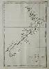
Imprint: Paris, 1835
330 x 220 mm., some very light foxing in the margin, otherwise in good condition.
"Dumont D'Urville's 1835 chart of New Zealand was the most accurate of the time" (Hooker). It was published in 'Voyage Pittoresque Autour du Monde' issued in two volumes 1834-35 and engraved by Ambroise Tardieu. It illustrates the voyage of Jean-Francois de Galoup, Comte de La Perouse who led a French scientific expedition to the Pacific in 1785-88. He was one of the most noted naval commanders and navigators in France and was selected by King Louis XVI to complete Captain James Cook's exploration of the western Pacific. In a rare moment of co-operation the British Admiralty furnished scientific equipment to measure variations in magnetic north and for determining longitude. Fortunately for us La Perouse was meticulous in sending copies of his detailed logs and surveying via other ships as well as overland. His last contact was in the spring of 1788 with a British ship in Botany Bay, Australia. The expedition was never heard from again. When the French Government realised that it had been lost they decided to publish an account as in many other ways it is regarded as one the greatest French voyages of exploration. It was not until 1827 that their fate was known. Ferguson 1771; Hill p. 88; Hooker, Brian. (1988). The French contribution to early printed charts of New Zealand, in 'The Map Collector' no. 43 pp. 18-25.
Stock number:9390.
|
|
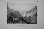
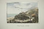
Imprint: Paris, 1830
290 x 345 mm., in good condition.
A lithographic view of a volcanic ravine on the island of Ascension in the Atlantic Ocean. It was published in Dumont D'Urville's 'Voyage de la Corvette L'Astrolabe' issued in several parts in 1830. The view represents the visit of the French Admiral and explorer, le Comte de La Pérouse in 1786. La Perouse's voyage ended in tragedy when they were lost after leaving Botany Bay in March 1788. It was not until 1827 that their fate was known, this book marks that finding. Ferguson 1341; Hill p. 88.
Stock number:6392.
|
|
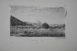
Imprint: Paris, 1830
270 x 330 mm., in later wash colour, good condition.
A lithographic view from near the summit of Green Mountain on the island of Ascension in the Atlantic Ocean. It is notable for the large scale man-made forest now present. It was published in Dumont D'Urville's 'Voyage de la Corvette L'Astrolabe' issued in several parts in 1830. The view represents the visit of the French Admiral and explorer, le Comte de La Pérouse in 1786. La Perouse's voyage ended in tragedy when they were lost after leaving Botany Bay in March 1788. It was not until 1827 that their fate was known, this book marks that finding. Ferguson 1341; Hill p. 88.
Stock number:9394.
|
|
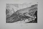
Imprint: Paris, 1830
250 x 370 mm., in good condition.
A fine lithographic view of Sandy Bay in the island of Ascension in the Atlantic Ocean. It was published in Dumont D'Urville's 'Voyage de la Corvette L'Astrolabe' issued in several parts in 1830. The view represents the visit of the French Admiral and explorer, le Comte de La Pérouse in 1786. La Perouse's voyage ended in tragedy when they were lost after leaving Botany Bay in March 1788. It was not until 1827 that their fate was known, this book marks that finding. Ferguson 1341; Hill p. 88.
Stock number:6389.
|
|
Imprint: Paris, 1830
275 x 370 mm., in good condition.
A lithographic view in the island of Ascension in the Atlantic Ocean. It was published in Dumont D'Urville's 'Voyage de la Corvette L'Astrolabe' issued in several parts in 1830. The view represents the visit of the French Admiral and explorer, le Comte de La Pérouse in 1786. La Perouse's voyage ended in tragedy when they were lost after leaving Botany Bay in March 1788. It was not until 1827 that their fate was known, this book marks that finding. Ferguson 1341; Hill p. 88.
Stock number:6390.
|
|