|
|
|
Imprint: London, J. S. Virtue & Co., Limited, City Road, 1886
Binding: Hardback Quarto (365 x 265 mm.), full contemporary publishers red cloth binding, ornate black panelling to boards with central title, decorative spine, worn. With 72 coloured maps. Otherwise in good condition.
This series of maps was first issued as The National Gazetteer in parts from 1863-68. It was then made available as a twelve volume work in 1868. Their next appearance was here in atlas form, with some accompanying descriptive text. William Hughes (1818-76) worked as a cataloguer at the British Museum on geography books from 1841-43. From 1863-75 he was a Professor of Geography at Kingâs College, London, and wrote several theoretical works on the subject. The founder of the publishing firm was George Virtue (c.1793-1868), whose company records show Hughes as a supplier of plates. The maps here are attractive and of individual counties except for Scotland where they are grouped together in regions. Those of Ireland are individual. They are all derived from the Old Series One Inch Ordnance Survey. In 1873 they were issued as A New County Atlas of Great Britain and Ireland. The map of the North Atlantic now acted as a frontispiece and the county maps began with Northumberland working their way south to Cornwall. This new atlas edited by Professor Keane is expanded to include information from the Redistribution of Seats Act of 1885. The Index now lists the map alphabetically and new plates are included displaying town plans. Provenance: ownership inscription on front free endpaper of 'Mary Rose Lee Warner, Wimpole Lodge, Arrington, Nr. Royston, Herts'; Clive A Burden Ltd. Catalogue 14 (2017) item 45; private English collection. Batten & Bennett (2010) 144; Beresiner (1983) p. 117; Carroll (1996) 126; refer Chubb (1927) 562; Tooley's Dictionary (1999-2004).
Stock number:10328.
|
|

Imprint: London, 1635-[37]
165 x 235 mm., with English text to the verso and letterpress English text in left margin, otherwise in good condition.
A fine detailed map of Brandenburg and Pomerania from the 'Historia Mundi', an English edition of Gerard Mercator's 'Atlas Minor' first published in 1607. Published in London by Michael Sparke and Samuel Cartwright there were several additional maps engraved for the work one of which is this. Shirley BL Atlases T.Hon-1e no. 123.
Stock number:5767.
|
|
|
Imprint: London, 1874
Binding: Hardback Contemporary open burgundy cloth slipcase with gilt title as above, with 6 large folding maps, each approximately 650 x 995 mm., all in early outline colour, all dissected and laid on contemporary linen, marbled endpapers with paper label, in good condition.
From 1800 the Post Office produced Directories. By 1835 it had been sold to Frederick Kelly who continued to publish them by county as 'Kellys Post Office Directory'. From this date maps of the counties engraved by Benjamin Rees Davies were published to accompany them. In the 1870s new plates were introduced. These were the work of Frederick Bryer (1840?-1919) and like the previous plates were never used for direct intaglio printing. These lithographic transfers were published well into the twentieth century. Indeed Kelly's Directory only ceased publication in the 1970s. This is a group of Middlesex and the home counties as a collection. Hodson cites the Hertfordshire as being the first state is the Sussex according to Kingsley. This particular issue is not identified in Burgess' study of Kent but undoubtedly is the same. They are all likely to be first editions. Kingsley cites an 1882 edition of 'Kelly's Directory' stating 'the maps are sold separately at the following prices:- Plain Sheet ... 2s0d/ On Roller ... 4s0d/ In Case ... 5s0d'. Amongst the Explanatory Notes on each are found the size of each county in acres, its population according to the 1871 census and the number of Members of Parliament. Not in Burgess Kent 180; Hodson (1974) 123 A; Kingsley (1982) 133A; Smith (1985) Victorian pp. 141-2; Worms & Baynton-Williams (2011).
Stock number:9856.
|
|
|
Imprint: London, Kelly & Co., 19 & 20, Old Boswell Court, Temple Bar, 1853
Binding: Hardback Octavo (240 x 165 mm.), full modern red calf, spine retaining the original cloth gilt title label. With general typographic title, pp. xii, 679, (1), (2), 7-1198, 34, with 9 double page maps, some trimming to the side margins, otherwise in good condition.
From 1799 the Post Office began to produce Directories. By 1835 they were sold to Frederic Kelly who continued to publish them for each county as Kellyâs Post Office Directory. Frederic Festus Kelly (d.1883) began working for the Post Office in 1819 and by about 1835 was chief inspector of letter carriers. Part of his responsibilities at this point was the production of the London Directory, the first being in 1843. Effectively it was a private enterprise but undertaken with the permission of the Post Office. In 1845 he published one of the six Home Counties which included maps for the first time. Over the ensuing years several others were published of parts of the country.They were engraved by Francis Becker (1807-63) and Benjamin Rees Davies (1789?-1872). All of them were gathered into the Post Office Directory Atlas of England and Wales, [1861]. Each map is entitled Post Office Map of ⦠and contains political data as well as denoting Post Office Mail Order Towns. Whilst the atlas was never reissued, Kelly's Directories continued publication of the maps for some time and only ceased publication in the 1970s. This example includes the counties of East Anglia bound with the âSix Home Countiesâ. Beresiner (1983) pp. 128-9; refer Carroll (1996) 116; refer Chubb (1927) 546; Hodson (1974) 107D; Kingsley (1982) 115C; Smith (1985) pp. 141-2; Tooleyâs Dictionary (1999-2004); Worms & Baynton-Williams (2011).
Stock number:10341.
|
|

Imprint: London, c.1860
640 x 970 mm., early outline colour
From 1800 the Post Office produced Directories. By 1835 it was sold out to Frederick Kelly who from 1845 issued Kellys Post Office Directory for each county. From this date maps were published to accompany them. By studying the imprint address below this map of Surrey was available from 1845-68. A fine large scale map of the county, complete with cloth bound folder. Bookplate of Robert Washington Oates. Tooleys Dictionary.
Stock number:3751.
|
|
|
Imprint: London, Kelly and Co., 51, Great Queen Street, Lincoln's Inn Fields, W.C., 1878
Binding: Hardback Octavo (255 x 170 mm.), full contemporary red cloth, blind embossed panelling, central gilt coat of arms, rebacked preserving original spine, gilt title, advertisements on endpapers. With title, pp. xiii, (1), 1235-3314, and 3 large folding lithographic maps, with staining to lower gutter of final 50 pages or so, Kent and Surrey with some condition issues, otherwise in good condition.
From 1799 the Post Office began to produce Directories. By 1835 they were sold to Frederic Kelly who continued to publish them for each county as Kellyâs Post Office Directory. Frederic Festus Kelly (d.1883) began working for the Post Office in 1819 and by about 1835 was chief inspector of letter carriers. Part of his responsibilities at this point was the production of the London Directory, the first being in 1843. Effectively it was a private enterprise but undertaken with the permission of the Post Office. In 1845 he published one of the six Home Counties which included maps for the first time. Over the ensuing years several others were published of parts of the country. They were engraved by Francis Becker (1807-63) and Benjamin Rees Davies (1789?-1872). All of them were gathered into the Post Office Directory Atlas of England and Wales, [1861]. When that series reached the end of their lives, they were replaced with these larger maps derived largely from those of Edward Weller. This example contains three counties, each with name stamped on the paper edges. Both Burgess and Kingsley record that the maps are often missing or in poor condition. Kingsley does not record an example of this new map in the 1878 edition. With over 2000 pages of this work contains a wealth of information for researchers. Kelly's Directories continued publication of the maps for some time and only ceased publication in the 1970s. Beresiner (1983) pp. 128-9; Burgess (2009) 180; refer Carroll (1996) 116; refer Chubb (1927) 546; Kingsley (1982) 133C; Smith (1985) pp. 141-2; Tooleyâs Dictionary (1999-2004); Worms & Baynton-Williams (2011).
Stock number:10342.
|
|

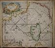
Imprint: Amsterdam, 1734
465 x 580 mm., with minor paper crease parallel to the centrefold, otherwise in good condition.
The firm of Van Keulen was founded around 1678 by Johannes van Keulen (1654-1715) and in 1680 he published the 'Zee Atlas'. The multi volume 'Zee Fakkel' followed soon after. On his 50th birthday he left the management of the firm to his talented son Gerard (1678-1726). Gerard set about replacing many of his fathers sea charts the first of which was published in 1698. This harbour chart depicts the city of Cette on the French coast of the Mediterranean Sea, now known as the Languedoc-Roussillon port of Sete. It is oriented to the west and bears two inset coastal profiles. The town itself is also depicted in profile. This example is from the third part of 'De Nieuwe Groote Lichtende Zee-Fakkel' dated 1724 which covered the Mediterranean Sea. De Vries, Schilder etc. 'The Van Keulen Cartography Amsterdam 1680-1885', pp. 44 & 202-5; Koeman IV p. 376 no. 306.
Stock number:7068.
|
|
Imprint: Amsterdam, c.1710
515 x 590 mm., in good outline colour, in good condition.
The firm of Van Keulen was founded around 1678 by Johannes van Keulen (1654-1715) and in 1680 he published the 'Zee Atlas'. The multi volume 'Zee Fakkel' followed soon after. On his 50th birthday he left the management of the firm to his talented son Gerard (1678-1726). Gerard set about replacing many of his fathers sea charts the first of which was published in 1698. This fine chart is of the Ligurian Sea and extends from the coast of Sardinia in the south to Italy and the island of Elba. The coastline extends westward to the Provencal port of Toulon in France. Dominating the map is the island of Corsica. The whole is finished with two ornate cartouche. This example is from the third part of 'De Nieuwe Groote Lichtende Zee-Fakkel' dated 1724 which covered the Mediterranean Sea. De Vries, Schilder etc. 'The Van Keulen Cartography Amsterdam 1680-1885', pp. 44 & 202-5; Koeman IV p. 381 no. 105 st. 2; Koeman 'The Sea on Paper' p. 37-8 no. 7.
Stock number:7054.
|
|

Imprint: Amsterdam, c.1730
515 x 590 mm., in good outline colour, in good condition.
The firm of Van Keulen was founded around 1678 by Johannes van Keulen (1654-1715) and in 1680 he published the 'Zee Atlas'. The multi volume 'Zee Fakkel' followed soon after. On his 50th birthday he left the management of the firm to his talented son Gerard (1678-1726). This particular chart depicts the waters between Sicily and Africa and is centred on the islands of Malta and Gozo. An inset lower right features the harbour of Valletta. This example is from the third part of 'De Nieuwe Groote Lichtende Zee-Fakkel' dated 1724 which covered the Mediterranean Sea. According to De Vries and Schilder it was introduced into the third volume in 1734. De Vries, Schilder etc. 'The Van Keulen Cartography Amsterdam 1680-1885', pp. 44 & 202-5; Koeman IV p. 391 no. 108 st. 2; Koeman 'The Sea on Paper' p. 37-8 no. 11.
Stock number:7057.
|
|

Imprint: Amsterdam, c.1730
515 x 590 mm., in good outline colour, trimmed at the top margin with no loss, otherwise in good condition.
The firm of Van Keulen was founded around 1678 by Johannes van Keulen (1654-1715) and in 1680 he published the 'Zee Atlas'. The multi volume 'Zee Fakkel' followed soon after. On his 50th birthday he left the management of the firm to his talented son Gerard (1678-1726). This map depicts the waters between North Africa and the islands of Malta and Gozo. The city of Tripoli is shown top centre. This example is from the third part of 'De Nieuwe Groote Lichtende Zee-Fakkel' dated 1724 which covered the Mediterranean Sea. De Vries, Schilder etc. 'The Van Keulen Cartography Amsterdam 1680-1885', pp. 44 & 202-5; Koeman IV p. 373 no. 175; Koeman 'The Sea on Paper' pp. 40 no. 1.
Stock number:7065.
|
|

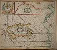
Imprint: Amsterdam, 1723
515 x 590 mm., in good condition.
The firm of Van Keulen was founded around 1678 by Johannes van Keulen (1654-1715) and in 1680 he published the 'Zee Atlas'. The multi volume 'Zee Fakkel' followed soon after. On his 50th birthday he left the management of the firm to his talented son Gerard (1678-1726). Gerard set about replacing many of his fathers sea charts the first of which was published in 1698. This superb rare chart is devoted to the Italian island of Sicily. It is completed with full topographical detail including rivers, mountains and towns. Mount Etna is depicted erupting. This example is from the third part of 'De Nieuwe Groote Lichtende Zee-Fakkel' dated 1724 which covered the Mediterranean Sea. This chart was first introduced into the third volume in 1723. De Vries, Schilder etc. 'The Van Keulen Cartography Amsterdam 1680-1885', pp. 44 & 202-5; Koeman IV p. 376 no. 313 st. 2.
Stock number:7073.
|
|
Imprint: Amsterdam, c.1730
515 x 590 mm., in good outline colour, backed on contemporary paper as issued, otherwise in good condition.
The firm of Van Keulen was founded around 1678 by Johannes van Keulen (1654-1715) and in 1680 he published the 'Zee Atlas'. The multi volume 'Zee Fakkel' followed soon after. On his 50th birthday he left the management of the firm to his talented son Gerard (1678-1726). Gerard set about replacing many of his fathers sea charts the first of which was published in 1698. This decorative sea chart centred on the island of Sardinia is orientated to the east. The coast of Africa is on the right and that of Corsica is shown to the left. Above is a large inset depicting the island of Tabarca off the coast of Barbary. This example is from the third part of 'De Nieuwe Groote Lichtende Zee-Fakkel' dated 1724 which covered the Mediterranean Sea. De Vries, Schilder etc. 'The Van Keulen Cartography Amsterdam 1680-1885', pp. 44 & 202-5; Koeman IV p. 381 no. 106 st. 3; Koeman 'The Sea on Paper' p. 37-8 no. 8.
Stock number:7055.
|
|

Imprint: Amsterdam, c.1730
515 x 590 mm., in fine recent outline colour, trimmed above just touching the neat line, margin extended, otherwise in good condition.
The firm of Van Keulen was founded around 1678 by Johannes van Keulen (1654-1715) and in 1680 he published the 'Zee Atlas'. The multi volume 'Zee Fakkel' followed soon after. On his 50th birthday he left the management of the firm to his talented son Gerard (1678-1726). This chart features the Adriatic Sea with Venice in the upper left. It extends to Corfu in the lower right and bears a large inset lower left of this island. Top right are two smaller insets of I. Pachu (Paxoi & Andipaxoi) and the mouth of the River Po. This example is from the third part of 'De Nieuwe Groote Lichtende Zee-Fakkel' dated 1724 which covered the Mediterranean Sea. De Vries, Schilder etc. 'The Van Keulen Cartography Amsterdam 1680-1885', pp. 44 & 202-5; Koeman IV p. 383 no. 110 st. 3; Koeman 'The Sea on Paper' p. 37-8 no. 13; Zacharakis, C. 1182.
Stock number:7074.
|
|

Imprint: Amsterdam, c.1730
515 x 590 mm., in good outline colour, trimmed at the top margin with no loss, margin extended, otherwise in good condition.
The firm of Van Keulen was founded around 1678 by Johannes van Keulen (1654-1715) and in 1680 he published the 'Zee Atlas'. The multi volume 'Zee Fakkel' followed soon after. On his 50th birthday he left the management of the firm to his talented son Gerard (1678-1726). This sea chart orientated to the east depicts the Holy Land and is dominated by the island of Cyprus. This example is from the third part of 'De Nieuwe Groote Lichtende Zee-Fakkel' dated 1724 which covered the Mediterranean Sea. De Vries, Schilder etc. 'The Van Keulen Cartography Amsterdam 1680-1885', pp. 44 & 202-5; Koeman IV p. 381 no. 115 st. 2; Koeman 'The Sea on Paper' p. 37-8 no. 18; not in Stylianou.
Stock number:7064.
|
|

Imprint: Amsterdam, c.1730
515 x 590 mm., in good outline colour, small light water stain just in to the upper corners, trimmed just to the neat line with no loss at lower centrefold, otherwise in good condition.
The firm of Van Keulen was founded around 1678 by Johannes van Keulen (1654-1715) and in 1680 he published the 'Zee Atlas'. The multi volume 'Zee Fakkel' followed soon after. On his 50th birthday he left the management of the firm to his talented son Gerard (1678-1726). Gerard set about replacing many of his fathers sea charts the first of which was published in 1698. The map shows the southern coast of Spain from Alicante in the north to Malaga in the south. The coast of north Africa is shown at the bottom. Insets upper left detail the coastline of Gata and harbour plans of Almeria, Cartagena, Zafarinos and Buzema. This example is from the third part of 'De Nieuwe Groote Lichtende Zee-Fakkel' dated 1724 which covered the Mediterranean Sea. De Vries, Schilder etc. 'The Van Keulen Cartography Amsterdam 1680-1885', pp. 44 & 202-5; Koeman IV p. 381 no. 102 st. 2; Koeman 'The Sea on Paper' p. 37-8 no. 4.
Stock number:7050.
|
|

Imprint: Amsterdam, c.1730
515 x 590 mm., in fine recent outline colour, trimmed above but not affecting the neatline, margin extended, a paper crease on the left half running parallel to the centrefold, otherwise in good condition.
The firm of Van Keulen was founded around 1678 by Johannes van Keulen (1654-1715) and in 1680 he published the 'Zee Atlas'. The multi volume 'Zee Fakkel' followed soon after. On his 50th birthday he left the management of the firm to his talented son Gerard (1678-1726). Gerard set about replacing many of his fathers sea charts the first of which was published in 1698. This attractive chart extends from the coast of Sardinia in the west to Sicily in the south. The Italian coastline from the Straits of Messina to Elba are shown. This example is from the third part of 'De Nieuwe Groote Lichtende Zee-Fakkel' dated 1724 which covered the Mediterranean Sea. De Vries, Schilder etc. 'The Van Keulen Cartography Amsterdam 1680-1885', pp. 44 & 202-5; Koeman IV p. 381 no. 107 st. 3; Koeman 'The Sea on Paper' p. 37-8 no. 10.
Stock number:7056.
|
|
|
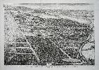
Imprint: London, J. Wyld & Son Geographer to the King, Charing Cross East, 1836
1140 x 1420 mm., dissected and laid on thick paper in four sections, early outline colour, otherwise in good condition.
This survey of the Belvoir hunt was 'Accurately laid down from a Survey taken in the years 1804. 5. & 6' by William King (fl.1791-c.1810). It is only the second to be undertaken since that in Saxton's time. Belvoir Castle in Leicestershire was first built shortly after the Norman conquest in 1066 and has since been rebuilt at least three times. It is the Seat of the Dukes of Rutland, to whom this map is dedicated. The fifth Duke chose the architect James Wyatt to rebuild the castle around 1800. Nearing completion in 1816, it was almost destroyed in a fire. Major art works were lost with an estimated value of £120,000 including pictures by Titian, rubens, van Dyck and Reynolds. It is situated at the heart of one of the most famous fox-hunting regions of the country. The Belvoir Hunt was established in 1750.This is the second 'Corrected' edition of this rare map first published in 1806, both are rare. It details many of the features of interest to fox hunters, namely the nature of enclosed areas such as gorse, thorns or pasture. Many minor roads and tracks are identified and the variation of magnetic north is recorded. This edition is published by James Wyld & Son. James Wyld (1790-1836) was joined by his son of the same name but died 14 October 1836, the year of this publication. Provenance: Dominic Winter 6 May 2010 lot 31. Baum (1972) p. 24; Carroll (1996) p. xxv; Deadman (2010) p. 136; Eden (1975); Tooley's Dictionary (1999-2004); Worms & Baynton-Williams (2011).
Stock number:10400.
|
|
Imprint: London, c.1715
340 x 475 mm., in good condition.
David Mortier (1673-c.1728) first published the 'Britannia Illustrata' in 1707. The work was expanded over several years last being issued in 1749 by John Bowles. From 1709 Joseph Smith also became a publisher of it. It is without doubt one of the most important topographical productions of Britain in the eighteenth century. Many of the plates were engraved by Johannes Kip (1653 - 1722) initially from the birds-eye views of Leonard Knyff (1650-1722). Later Kip would undertake both drawing and engraving. Kip began his trade working in Amsterdam under William of Orange. Following the Glorious Revolution of 1688 Kip accompanied the Court to London. From Westminster he became a print seller and engraver. The first house here was built by Sir Richard Morrison in 1546 who adapted a former monastery. It shortly after became the home of the Earls of Essex. The widow of the seventh Earl however had to sell it to pay death duties and the house was demolished. Adams (1983) no. 22; Worms and Baynton-Williams.
Stock number:8091.
|
|

Imprint: London, David Mortier, 1707
470 x 585 mm., in good condition.
A wonderful prospect of Christs Church, Oxford, first published by David Mortier (1673-c.1728) in the 'Britannia Illustrata' in 1707. The work was expanded over several years last being issued in 1749 by John Bowles. From 1709 Joseph Smith also became a publisher of it. It is without doubt one of the most important topographical productions of Britain in the eighteenth century. The plates were engraved by Johannes Kip (1653 - 1722) initially from the birds-eye views of Leonard Knyff (1650-1722). Later Kip would undertake both drawing and engraving. Kip began his trade working in Amsterdam under William of Orange. Following the Glorious Revolution of 1688 Kip accompanied the Court to London. From Westminster he became a print seller and engraver. Adams (1983) no. 22; Worms and Baynton-Williams.
Stock number:7916.
|
|

Imprint: London, 1720
55 x 88 cms., in two sheets pasted together. With some marginal chips repaired, not effecting the image.
A fine large early engraved view of the town and castle of Windsor. Dedicated to Queen Anne. Adams 'London Illustrated 1604-1851' 22 no. 43.
Stock number:3837.
|
|