|
|
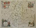
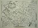
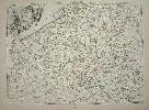
Imprint: Amsterdam, c.1650
370 x 480 mm., early outline colour with French text to the verso, in good condition.
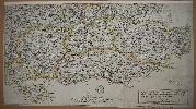
This map was originally published in Jan Jansson's 'Atlas Novus'. When compared to the rival Blaeu county maps those of Jansson always appear more decorative. Jansson was a very successful publisher who continued the business first founded by the great Gerard Mercator and subsequently taken over by the Hondius family. This particular map is of Nottinghamshire, the French text is taken from Camden's 'Britannia'. Hodson 130; Skelton no. 34; Van der Krogt, P. (Atlantes) 5335:1.
Stock number:5556.
|
|
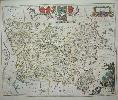
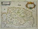
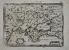
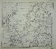
Imprint: Amsterdam, c.1690.
38 x 48 cms., in fine early wash colour. With very large margins and on good paper, one small wormhole in the right margin.
This map was originally published in Jan Jansson's 'Atlas Novus'. When compared to the rival Blaeu county maps those of Jansson always appear more decorative. Jansson was a very successful publisher who continued the business first founded by the great Gerard Mercator and subsequently taken over by the Hondius family. This particular map is of Essex. Hodson 130; Skelton no. 34; Van der Krogt, P. (Atlantes) 5280:1.
Stock number:3869.
|
|
Imprint: Amsterdam, 1646
44 x 55 cm. Early outline colour
ex 'Atlas Novus'. When compared to the rival Blaeu county maps those of Jansson always appear more decorative. Refer Skelton no. 34
Stock number:2564.
|
|
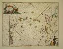
Imprint: Amsterdam, 1650
400 x 510 mm., in early outline colour with some GOLD to the central compass rose, in good condition.
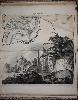
This attractive sea chart is oriented to the east, the central compass rose pointing to the north is highlighted in GOLD. It displays the Leeward and Windward islands stretching between Puerto Rico and South America. All of the islands are named, and the whole is beautifully ornate with lovely colour. The decorative title cartouche includes Neptune and cherubs. Lower right the map is embellished with a native holding the scale of miles. A superb chart first published in Johannes Janssonius' 'Atlantis Majoris' the first sea atlas of the world only pre-dated by the much more cumbersome six-volume 'Arcano del Mare' by Sir Robert Dudley in 1646-7. With no text on the verso as issued. Koeman 652; Van der Krogt, P. (Atlantes) 9640:1.
Stock number:6263.
|
|
Imprint: Amsterdam, 1648
130 x 190 mm. Uncoloured, ulightly browned.
ex'Atlas Minor'.
Stock number:2748.
|
|
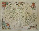
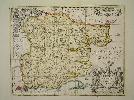
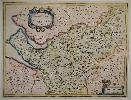
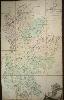
Imprint: Amsterdam, c.1650
430 x 550 mm., in fine early outline colour with wash to the cartouches, with very faint waterstain lower centrefold just into the margin, small 10 mm., tear nearby repaired, otherwise in good condition.
This map was originally published in Jan Jansson's 'Atlas Novus'. When compared to the rival Blaeu county maps those of Jansson always appear more decorative. Jansson was a very successful publisher who continued the business first founded by the great Gerard Mercator and subsequently taken over by the Hondius family. This particular map is of Leicestershire and Rutland, the German text is taken from Camden's 'Britannia'. Baum pp. 22-3; Deadman & Brooks pp. 36; Hodson 130; Skelton no. 34; Van der Krogt, P. (Atlantes) 5320:1.
Stock number:5563.
|
|
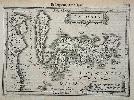
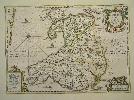
Imprint: Amsterdam, 1636
380 x 490 mm., in modern outline colour, in good condition.
By the 1630s the publication houses of Willem Blaeu and Henricus Hondius were in a race to produce ever more new maps of the world. Hondius in partnership with Jan Jansson began collecting plates of Britain and in 1636 published an 'Appendix' of the 'Atlas' including 17 maps, two of which were general ones. Unfortunately they were not ready in time for the English edition published in 1636 and are only found in the German edition. This marks the beginning of the race between the two houses to produce a separate volume devoted to England and Wales which Blaeu would win in 1645. In 1644 a further 11 maps were issued in a Dutch 'Appendix'. Examples of maps from these early issues are very rare and highly desirable. The plates are often extensively altered for their ultimate issue in the completed work of 1646.A very rare example of the FIRST STATE of Jan Janssons map of the county of Norfolk. One of the fifteen so called pre-issue maps published in 1636 before the final work was completed in 1646. The most notable feature of this early state is the larger decorative title cartouche upper right, and the lack of shields upper left. The scale of miles is moved from upper left to lower left. Frostick Norfolk 12.1; Koeman (1967-70) II ME 44 no. 414; Van der Krogt (1997-2003) 5295:1.1; Map Collectors Circle Notes and Addenda pp. 16-18; Skelton (1970) pp. 225-6.
Stock number:5558.
|
|
|
Imprint: Amsterdam, c.1652
Binding: Hardback Folio (475 x 315 mm.), early half calf binding, thick boards, marbled paper boards, rebacked preserving original spine, spine with gilt and blind ruled compartments, calf gilt title label affixed. With 97 maps, many laid on contemporary paper, NO TEXT on the verso, very sharp impressions, in good condition.
Johannes Jannsonius (1596-1664) was the great rival of the Blaeu family of publishers. In 1630 Blaeu published his Appendix which was a challenge to the pre-dominance of the Mercator-Hondius atlases of the day. A publishing race ensued and Jodocus Hondius joined forces with Janssonius who co-published and distributed the 'Atlas Novus'. It was expanded over the years to six volumes and eventually formed 12 volumes in the Atlas Major.This volume is notable for having NO TEXT on the verso. Skelton states on page 83 'the maps were also printed (probably continuously from 1646) without text on the back'.It's composition is also unusual not matching any of the volumes of the 'Atlas Novus'. It consists of three geographical sections; the Low Countries consisting of 36 maps, the British Isles in 52 maps and that of Scandinavia consisting of 9 maps. This is quite likely the second volume as the manuscript pagination begins with 97 and runs consecutively through the British section to 186. Those of Scandinavia run from 112 to 120. Clearly the atlas has been reconstructed. It is also notable that a small wormhole appears right through the British section into some of the Low Countries. This curiously only appears on the left side of the map indicating that these two sections were originally sidebound. The construction of the British section is interesting. It consists of just 52 maps, the first complete edition of 1644 contained 56. The differences are notable. Five maps are omitted; the Fens, the islands, the Channel Islands, Lothien and the Orkneys. One extra map is 'Cambriae Typus' was first published in the historical atlas of 1652. It is also noteworthy that the Somerset and Merionith and Montgomery are in proof states as issued in the Dutch edition of 1644. In 1640 Janssonius began work on a volume covering England and Wales. Progress was slow and it was not until the competition of Blaeus own atlas of England and Wales published in 1645 that Janssonius pushed his to completion the following year. The volume is finished with 9 maps of Scandinavia.Some conclusions can likely be made. The collection was put together either at the publishers or over a period of time as loose maps. The presence of the Welsh map, first issued in 1652, with consecutive numeration and the worm hole indicates that they were sidebound after that date. Later still they were rebound in a different order, in the normal folio manner, most likely in this binding which may well be early eighteenth century. An interesting bibliographical story. Provenance: Norwich Public Library; private English collection. Keuning (1947). The History of an Atlas. Mercator-Hondius, in 'Imago Mundi' 4, pp. 37-62; Koeman (1967-70) volume II pp. 395; Krogt (1997-2010) volume I pp. 238, 657-70; Skelton (1970) no. 34 and pp. 225-6.
Stock number:9773.
|
|
Imprint: Amsterdam, 1644
380 x 500 mm., small hole in the upper right margin, lower centre fold split, repaired, not affecting the image, otherwise in good condition.
By the 1630s the publication houses of Willem Blaeu and Henricus Hondius were in a race to produce ever more new maps of the world. Hondius in partnership with Jan Jansson began collecting plates of Britain and in 1636 published an 'Appendix' of the Atlas including 17 maps, two of which were general ones. Unfortunately they were not ready in time for the English edition published in 1636 and are only found in the German edition. This marks the beginning of the race between the two houses to produce a separate volume devoted to England and Wales which Blaeu would win in 1645. In 1644 a further 11 maps were issued in a Dutch 'Appendix'. Examples of maps from these early issues are very rare and highly desirable. The plates are often extensively altered for their ultimate issue in the completed work, the 'Atlas Novus' of 1646.An example of the very rare FIRST STATE of Jan Janssons county map of Kent. When compared to the rival Blaeu county maps those of Jansson always appear more decorative. This map of Kent, with German text to the verso taken from Camden's 'Britannia', was first published in 1644. All so-called pre-issue Jansson county maps are rare and desirable. A comparison of the two states shows that the extremely ornate title cartouche was entirely re-engraved along with numerous other alterations. Jansson was a very successful publisher who continued the business first founded by the great Gerard Mercator and subsequently taken over by the Hondius family. Burgess 15 state 1; Koeman (1967-70) II ME 75A no. 559; Van der Krogt (1997-2003) 5290:1.1; Map Collectors Circle 34 'Notes and Addenda' pp. 16-18; Skelton (1970) no. 34, pp. 225-6.
Stock number:7441.
|
|
Imprint: Amsterdam, 1628
150 x 200 mm., in good condition.
The map was engraved by Petrus Kaerius who places an ornate title cartouche upper left. It was produced to be included in Jan Jansson's edition of Mercator's 'Atlas Minor'. With Latin text on verso. Van der Krogt, P. (Atlantes) 1890:352.1.
Stock number:8116.
|
|
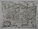
Imprint: Amsterdam, 1636
385 x 505 mm., a tear to the lower margin with an extremely professional repair, not effecting the image, in good condition. With German text to the verso.
By the 1630s the publication houses of Willem Blaeu and Henricus Hondius were in a race to produce ever more new maps of the world. Hondius in partnership with Jan Jansson began collecting plates of Britain and in 1636 published an Appendix of the Atlas including 17 maps, two of which were general ones. Unfortunately they were not ready in time for the English edition published in 1636 and are only found in the German edition. This marks the beginning of the race between the two houses to produce a separate volume devoted to England and Wales which Blaeu would win in 1645. In 1644 a further 11 maps were issued in a Dutch Appendix. Examples of maps from these early issues are very rare and highly desirable. The plates are often extensively altered for their ultimate issue in the completed work of 1646.A very rare example of the FIRST STATE of Jan Janssons map of the county of Cheshire. One of the fifteen so called pre-issue maps published in 1636 before the final work was completed in 1646. The most notable feature of this early state of Cheshire is the decorative title cartouche upper left, in the finished state it is moved lower left and replaced by seven coats of arms. Not so noticeable is that the imprint of Jan Jansson lower right below the scale of miles is erased and replaced with a whole new cartouche for the scale only. Janssons name is left out altogether. Koeman (1967-70) II ME 44 no. 414; Van der Krogt (1997-2003) 5375:1.1; Map Collectors Circle Notes and Addenda pp. 16-18; Skelton (1970) pp. 225-6.
Stock number:4902.
|
|
Imprint: Amsterdam, 1636
385 x 505 mm., full early wash colour, with German text to the verso, in very good condition.
By the 1630s the publication houses of Willem Blaeu and Henricus Hondius were in a race to produce ever more new maps of the world. Hondius in partnership with Jan Jansson began collecting plates of Britain and in 1636 published an Appendix of the Atlas including 17 maps, two of which were general ones. Unfortunately they were not ready in time for the English edition published in 1636 and are only found in the German edition. This marks the beginning of the race between the two houses to produce a separate volume devoted to England and Wales which Blaeu would win in 1645. In 1644 a further 11 maps were issued in a Dutch Appendix. Examples of maps from these early issues are very rare and highly desirable. The plates are often altered extensively for their ultimate issue in the completed work of 1646.This is a very rare example of the FIRST STATE of Janssons map of the county of Cheshire. One of the fifteen so called pre-issue county maps published in 1636 before the final work was completed in 1646. The most notable feature of this early state of Cheshire is the decorative title cartouche upper left, in the finished state it is moved lower left and replaced by seven coats of arms. Not so noticeable is that the imprint of Jan Jansson lower right, below the scale of miles, is erased and replaced with a whole new cartouche for the scale only. Janssons name is left out altogether. Koeman (1967-70) II ME 44 no. 414; Van der Krogt (1997-2003) 5375:1.1; Map Collectors Circle Notes and Addenda pp. 16-18; Skelton (1970) pp. 225-6.
Stock number:7079.
|
|
Imprint: Amsterdam, 1647
340 x 490 mm., with fine early outline colour in excellent condition.
This third version of Jodocus Hondius's original plate first appeared in 1647. It varied considerably from the earlier works with a cartouche upper right, sailing ships re-instated. Booth no. 5; Van der Krogt, P. (Atlantes) 5500:1B.
Stock number:4712.
|
|
Imprint: Paris, 1773
480 x 660 mm., early outline colour in good condition.
Jean Denis Janvier (fl. 1746-80) was a French geographer and cartographer in the Rue St. Jacques in Paris. His maps are usually known for their attractive title cartouche's of which this is an example. The map covers modern day Belgium and Luxembourg. Tooley's Dictionary.
Stock number:4668.
|
|
Imprint: London, 1748
240 x 260 mm., in good condition.
This attractively engraved map of the Baltic Sea by Thomas Jefferys was published in the March 1748 issue of the Gentleman's Magazine. A legend gives the details of the Treaty of Abo of the 16 June 1743 between Sweden and Russia. Jolly, D.C. (Brit Per) GENT-55.
Stock number:4655.
|
|
|
Imprint: London, R. Sayer and J. Bennett, Map and Print Sellers, No. 53 Fleet-Street, 1775
Binding: Hardback Oblong quarto (180 x 235 mm.), recent half calf, marbled boards, with marbled endpapers. With typographic title page, Preface, 16 page index to places named and 104 numbered road strips printed back to back. Title and final leaf browned, title with slight tear near binder's tie, otherwise in good condition.
This is an example of a series of French engraved plates on England and Wales being acquired by the English for publication at home. Despite being published in 1775 circumstantial evidence leads us to surmise that the plates for this work were acquired sometime in 1766. The preface states that âThe plates for the following Work were originally intended for an account of these Roads in Frenchâ. They were first published by George Louis Le Rouge in 1759 and re-issued by Louis Charles Desnos in 1766-[67]. It goes on to state that by âfalling into the hands of the late Mr. Jefferys and the Editor, it was thought they might be the foundation of a work in Englishâ. We may assume therefore that it was Thomas Jefferys who acquired the plates, which is interesting as he declared bankruptcy in November 1766, the year found on the title page of the Desnos edition. Robert Sayer came to his rescue and enabled him to continue in business albeit now owning much of his stock. Therefore, it may be concluded that Jefferys, a frequent traveller to Paris, acquired the plates late in 1766 and ownership of them passed to Robert Sayer. Together they finished the project.Jefferys died in 1771 which may have contributed to the delay in publication. The Preface goes on to state that âto render it the most compleat and exact of any yet published on this useful plan, all materials on the subject have been consulted ⦠so that it contains several thousand names of places on and adjacent to the Roads, which are not to be found in any other collection: and ⦠there are added all the smaller branches leading from the considerable market-towns to each other, together with a very full Index, which, we flatter ourselves, will make this Book the best direction for travelling through this Kingdomâ.The original plates were in French and a remarkable amount of work has gone into translating this. Hundreds of routes which used to be marked âà Kensingtonâ for instance are altered to become âto Kensingtonâ in many cases the accent remains. However, it is not comprehensive, for instance on plate 5, the fifth strip still bears two unaltered. As alluded in the Preface there are extensive additions to all the plates of new information. Many also bear English notations in the lower margin and all have the imprint of Sayer and Bennett dated 16 January 1775, either top or bottom. Each plate title is translated into English and now includes the distances of many towns along the route. Three entirely new plates are engraved, the first covers the road From London to Aylesbury. The second includes the routes From London to Rygate in Surrey and The New Road from Paddington to The Eagle on Epping Forrest. The final plate includes St. Albanâs to Ware and London to Hitchin. These are numbered 102-104.New preliminary leaves include three indexes to places named on the Principal Roads, Cross Roads and finally a list of the Principal Roads. Provenance: with indecipherable manuscript initials to the title page; private English collection; Clive A Burden Ltd. (2017) Catalogue 14 item 41. Bennett (1996) pp. 72-4; Carroll (1996) App. 13; Chubb (1927) 144; Fordham (1924) p. 29; Shirley (2004) T.Say 3a; Smith, David (1991a & b).
Stock number:10171.
|
|
Imprint: London, Robert Sayer and John Bennett, 1778-[79]
Edition: First Edition Binding: Hardback Folio (555 x 400 mm.), contemporary half calf, marbled boards. Ribbed spine with seven compartments, gilt ruled, with gilt calf title. Some moderate wear to the spine. With typographic title as transcribed above and index numbered to 30, with 23 maps (11 folding, 11 double-page and 1 single-page) numbered to 29 using 49 copper plates. All with early outline colour. Mounted on guards throughout. With water stain affecting map number 9. The condition of the maps is generally good, some light offsetting. There are a couple of minor creases as one would expect on a couple of the large folding maps.
A superb clean, strong example of an important atlas. Thomas Jefferys (1719-71) was arguably the most important English cartographer during the eighteenth century. A publisher, engraver, author and geographer of some note he was appointed Geographer to Frederick Prince of Wales in 1748, and later to King George III. It was during the Seven Years War that Jefferys made a name for himself as an authority on North American cartography. Many of those important maps are present in the atlas offered here. His other great contribution was in English County cartography being involved with a number of county atlases. But it was his large scale maps of the counties that extended his finances too far. His map of Devonshire in 1765 won the first ever prize of £100 offered by the Royal Society of Arts. By 1766 he was forced into bankruptcy. To survive Jefferys entered into partnerships, the most important of which was with the London map and printseller Robert Sayer. In 1768 his attention turned back to America when they published 'A General Topography of North America and the West Indies'. When Jefferys died in 1771, Sayer purchased a large amount of his stock. Sayer by then was in partnership with John Bennett. Together they continued to publish Jefferys maps, compiling amongst other atlases 'The American Atlas' offered here.This is arguably the first American state atlas displaying as it does for the first time all of the American colonies in great detail. Ristow stated that as a
major cartographic reference work it was very likely consulted by American, English and French civilian administrators and military officers during the Revolution. The first edition is dated 1775 with further issues in 1776, 1778, 1782, 1794 and 1800. The dates on the actual maps can be later than that on the title page. This is an example dated 1778 on the title page with the latest dated map being that of South America 1 July 1779. Amongst the significant maps included in this atlas are the surveys of the American continent in 6 sheets, Nova Scotia with Cape Breton Island, and New England by Braddock Mead (alias John Green), William Brasier's survey of Lake Champlain and the upper Hudson River valley, New York and New Jersey by Samuel Holland, the English edition of William Scull's map of Pennsylvania, Virginia by Joshua Fry and Peter Jefferson (father of Thomas, the third US President), the Carolinas by Henry Mouzon and Lieutenant Ross's map of the Mississippi River. A full list of contents is available. Provenance: private English collection acquired 1970s; private English collection. Harley, 'Imago Mundi' XX pp. 27-48; Howes J81; Phillips Atlases 3659a; Pritchard & Taliaferro p. 211; Ristow, Introduction to the facsimile edition (Amsterdam, Theatrum Orbis Terrarum, 1976); Sabin 35953; Shirley, BL T.JEF 2c; Streeter I 72.
Stock number:1937.
|
|
Imprint: London, c.1765
Binding: Hardback 1860 x 1140, in eight sheets cut and dissected into 32 panels mounted on linen, in full early wash colour, lower left corner with replacement cloth, one small split of original cloth repaired, otherwise in good condition.
Thomas Jefferys (1719-71) was arguably the most important English cartographer during the eighteenth century. A publisher, engraver, author and geographer of some note he was appointed Geographer to Frederick Prince of Wales in 1748, and later to King George III. It was during the Seven Years War that Jefferys made a name for himself as an authority on North American cartography. His other great contribution was in English County cartography being involved with a number of county atlases. But it was his large scale maps of the counties that extended his finances too far. His map of Devonshire in 1765 won the first ever prize of £100 offered by the Royal Society of Arts. By 1766 he was forced into bankruptcy. To survive Jefferys entered into partnerships, the most important of which was with the London map and printseller Robert Sayer. This large scale map of Bedfordshire was published at that critical period of his life and it appears that he needed the assistance of Andrew Dury to publish it. The original survey was undertaken by John Ainslie (1745-1828) and Thomas Donald (fl.1750-c.97). Ainslie was a noted surveyor, mapmaker, engraver and publisher. According to Tooleys Dictionary this is his earliest work produced when just 20 years old. He is most famous for his Scottish material. It was also the earliest printed work for the surveyor Donald who was less prolific. Rodger (1972) no. 2; Tooley The Map Collector Bd5; Tooleys (1999-2004).
Stock number:6347.
|
|
Imprint: London, 1772
Edition: First Edition Binding: Hardback Large folio (620 x 390 mm.), contemporary half russia, gilt stamped red calf title label affixed to both boards, with marbled endpapers, blank endpapers, Jeffreys map of Yorkshire in 20 sheets in early outline colour each approximately 600 x 600 mm., including key map as plate V; bound with the Tuke large scale map of the county in 4 sheets, each approximately 600 x 725 mm., each in full early wash colour; bound with Tuke's map of Holderness 625 x 485 mm. With light offsetting to the Jefferys, some foxing to the Holderness otherwise in very good condition.
A wonderful bound collection of large scale maps of Yorkshire with a fine provenance including the extremely rare FIRST EDITION OF THE JOHN TUKE map. The first map within is by Thomas Jefferys (1719-71) and is an example of the FIRST EDITION of his great twenty-sheet large scale map of the county of Yorkshire. It was however issued posthumously as he died 20 November 1771. He was one of the great architects behind the rise of the large scale mapping of English counties during the middle of the eighteenth century. The survey of Yorkshire was undertaken by John Ainslie (1745-1828), Thomas Donald (fl.1750-c.1797) and Joseph Hodskinson (1735-1812) between 1767 and 1770. It is published on a scale of one inch to the mile and is considered one of Jefferys' finest productions. It consists of a general map as sheet V, a fine double page engraved title and excellent plans of Sheffield, Leeds, Ripon, Kingston-upon-Hull and Scarborough mostly drawn to the great scale of 132 yards to the inch. It also contains fine views of Middleham Castle and Fountains Abbey engraved by William Walker (1729-93) after Nicholas Thomas Dall. The map illustrates the three Ridings and also the individual Wapontakes with early outline colour.Bound with the FIRST STATE of the A VERY RARE separately published large scale map of Yorkshire by John Tuke. Little is known of Tuke in the carto-bibliographies other than that he was a land surveyor in York with printed maps issued between 1787 and 1798. Further research identifies the Tuke family as Quaker innovators. Members were behind what became the Rowntree's Cocoa Works, the Retreat Mental Hospital and three Quaker schools. John Tuke (30 June 1759-19 January 1841) was the fourth born or five children to William Tuke (1732-1822) and Elizabeth Hoyland (1729-60). William Tuke was a tea merchant and grocer in York and a pioneer in work on mental health. Our John Tuke was born in Lincroft, Bishopshill, York and married Sarah Mildred (1762-1829), daughter of Daniel Mildred and Lydia Daniel, on 16 Apr 1783. They had eight children and he died in Bishophill, York. In 1787 he would publish two maps, one of the region of Holderness (also found here) in Yorkshire, the other being this large four-sheet map of the whole county. Lower right below the beautiful engraved title cartouche of a north east view of York is the imprint of 'Wm. Darton Engr.. Birchin Lane, London'. It is unclear from this whether he is responsible for just the title cartouche or the whole map. Two insets appear on the map of which that upper right is entitled 'Reduced Map of the County of York describing the Roman Roads & c. and also the intended Grand Canal betwixt the Rivers Ouse and Humber ...' The Explanation below describes the different typography used to illustrate the Market towns, Parishes and other villages etc. Churches, Country Seats and Parks are also singled out as are the differing types of roads and, rivers, boundaries and the divisions of the Wapontakes. Lower left is an inset plan of Kingston upon Hull surveyed by Anthony Bower (fl.1781-1813+) in 1786. Copac only records four examples in institutions: British Library; Brotherton Library, Leeds (2 examples); Allen Collection, Bodleian Library, Oxford. Rodger in her extensive survey identifies six others. Beautifully wash coloured at the time by Wapontake. Bound with the rare separately published map of Holderness in the East Riding of Yorkshire. John Tukes map of Holderness is of particular significance and, due to its large scale, it is possible to recognise areas which have now been eroded by the sea (Rawnsley). Actual distances to the sea from five villages are given but the most interesting part of the map is the identification of several towns lost to the sea noted just offshore. Some are even in the Humber Estuary. Examples are Pensthorpe, Birstall Garth, Owthorne, Sandley Meer and Auburne which amongst others have all since disappeared into the sea. Previous places washed away are also noted such as Hartburn, washed away by the sea, Site of Hornsea Burton and others. This whole area of East Yorkshire has long been eroded by the sea, its most significant capture being Ravenser where King Henry IV landed in 1399. The town at one point rivalled Grimsby and Hull for importance. This map of Holderness includes Kingston upon Hull, Beverley and Hornsea.Provenance: Bears the bookplate of the Vernon-Harcourt family, most likely that of Edward Venables-Vernon-Harcourt (1757-1847), Archbishop of York. He was the third son of George Venables-Vernon, 1st Baron Vernon and it was he who inherited the Harcourt estate on the death of his cousin, the last of the Harcourt's. Collection of Ian Voase Askew (1921-2014), Wellingham Folly, Sussex. Eden (1975); Rawnsley (1970) 27 & 30; Rodgers (1972) 516 & 536, Whitaker 240; Worms & Baynton-Williams (2011).
Stock number:8684.
|
|
Imprint: London, 1644-[76]
280 x 505 mm., early outline colour, trimmed to the upper margin with some loss upper left, small area of loss along fold, repaired, otherwise in good condition.
This map is part of the great Quartermasters Map. It is known as this because of the general title referring to its usefulness to all Comanders for Quarteringe of Souldiers, & all sorts of Persons, that would be informed, Where the Armies be; never so Commodiously drawne before this. 1644. It was as stated used widely during the English Civil War, particularly by the Parliamentarians with whom the publisher Thomas Jenners sympathies lay. Jenner (fl. c.1618-73, d.1673) was a print and map seller who set up in business at the White Bear in Cornhill about 1618. Until the impending Civil War Jenner was not known for cartographic material. Then in 1643 he published a revised edition of the 'Direction for the English Traviller' whose plates he had acquired from his printer Matthew Simmons. Jenner had timed his move perfectly. Demand for maps and tools to help the large numbers of people moving about the country at the time of the Civil War was on the increase. The market for the little atlas clearly proved so great that he was attracted to do more. He engaged the services of the noted engraver Wenceslaus Hollar to etch a reduction of Christopher Saxtons great wall map of 1583. This would enable his customers to have a more detailed and yet still portable map of England and Wales.Hollar (1607-77) is described by Pennington in glowing terms: Of all etchers, Hollar is certainly the most varied in subject, one of the most accomplished in technique, and with a style that is full of a charm, a humour, and a good nature that are evidently the character of the man himself. He was born in Prague and made his way to England in the party of Lord Arundel arriving in London in late December 1636. By 1644 Hollar had already done some work for Jenner which included working on at least two of the re-engraved plates for the 'Direction for the English Traviller' published in 1643. The published history of the Quartermasters Map is long and complicated extending to 1824. Its earliest form is that which bears the date 1644 on the title. This was revised for the second edition in 1671. This is an example from the third edition published by John Garrett in 1676. Harley & Skelton (1972); Pennington (1982) 652-7; Shirley (1980) no. 537; Wing H2447.
Stock number:7312.
|
|