|
|
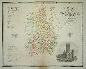
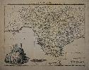
Imprint: London, Greenwood & Co, 1834
570 x 790 mm., early wash colour, some light offsetting otherwise in good condition.
Following the extensive work carried out by the Greenwood's on the series of large scale county surveys a reduced sized atlas was planned. It began as early as 1829, the date recorded on 11 of the plates. It was advertised in 1828 to appear in four parts at three guineas per part. There were to be 46 plates all at one-third of an inch to a mile. Running into financial difficulties towards the end they had to take in partners to finally finish in 1834. 'For detail, general accuracy and balance allied to high quality engraving and colouring these sheets are probably the finest ever single sheet maps of the counties' (Carroll). This map of Cambridgeshire contains a fine vignette view of Ely Cathedral. Tooley's 'Dictionary of Mapmakers', Chubb 458B.
Stock number:5490.
|
|
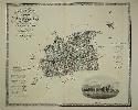
Imprint: London, Greenwood & Co, 1834
565 x 680 mm., early wash colour, with one small margin tear on the right repaired, otherwise in good condition.
Following the extensive work carried out by the Greenwood's on the series of large scale county surveys a reduced sized atlas was planned. It began as early as 1829, the date recorded on 11 of the plates including this one. It was advertised in 1828 to appear in four parts at three guineas per part. There were to be 46 plates all at one-third of an inch to a mile. Running into financial difficulties towards the end they had to take in partners to finally finish in 1834. 'For detail, general accuracy and balance allied to high quality engraving and colouring these sheets are probably the finest ever single sheet maps of the counties' (Carroll). This map of Surrey contains a fine vignette view of Lambeth Palace. Chubb 458B; Tooley's 'Dictionary of Mapmakers'.
Stock number:9282.
|
|
|
Imprint: London, By the Proprietors Greenwood, Pringle & Co. 13 Regent Street, Pall Mall, 21 December 1825
1535 x 1170 mm., four sheets cut, dissected and laid on contemporary linen, in full early wash colour, edged in green silk, marbled endpapers. Complete with contemporary full calf slipcase, gilt panelled, gilt ruled spine with blue calf gilt title label, a little worn, with very light offsetting near the title, otherwise in good condition.
This large scale map of Derby is by Christopher Greenwood (1786-1855) and his brother John Greenwood (1791-1867). They were both surveyors. Christopher Greenwood was from Yorkshire who settled in Wakefield by about 1815 before moving to London in 1818. His first large-scale survey was of Yorkshire published in 1817. His brother John was also a surveyor and in 1821 they joined forces. Along with the distribution capabilities of George Pringle and Son, they made an immediate impact with their series of large scale surveys of many English counties. This is one of four published in 1825. It is on a large scale of one inch to the mile and differentiates between woods and plantations, heaths and commons, different types of waterway and roads. Watermills, windmills, toll booths, coal mines and railways are identified indicating their significance to the local economy. The Little Eaton Tramway opened in 1795 was specifically built for the collieries. It was built by James Outram and was a horsedrawn line. It remained open until 1908. The early 1800s was a time of rapid change in the landscape with the burgeoning industrial revolution. A large vignette of Chatsworth House occupies the lower left corner. Their surveys utilised the latest system of triangulation adopted by Colonel Mudge and his surveyors for the Ordnance Survey. Indeed, they were in open competition with them. The Greenwood maps were coloured as opposed to the more functional black and white Ordnance Surveys of the period. Rodger (1972) 80; Tooley 'Large Scale' Map Collector 27 p. 37 D16; Tooley's Dictionary; Worms & Baynton-Williams (2011).
Stock number:9841.
|
|
|
Imprint: Wakefield & London, W. Fowler & C. Greenwood, Decr. 1st. 1818
2025 x 1385 mm., six sheets cut, dissected and laid on contemporary linen, marbled endpapers, green silk edging, in full early wash colour. Complete with contemporary full early calf slipcase, ornate gilt panelled, spine with raised bands, gilt ruled, each compartment with ornate central gilt feature, with blue calf title label, light wear. In very good condition.
This is only the second large scale map by Christopher Greenwood (1786-1855) preceded only by that of Yorkshire. He was a surveyor and mapmaker from Yorkshire who settled in Wakefield by about 1815 before moving to London in 1818. His first large-scale survey was of Yorkshire published in 1817. This second survey of Lancashire was co-published with William Fowler, also of Wakefield, in 1818. His brother John was yet to join him in the enterprise. The map is drawn by R. Creighton and engraved by Samuel John Neele (1758-1824) and his son James Neele (1791-1868). The early 1800s was a time of rapid change in the landscape with the burgeoning industrial revolution. Their surveys utilised the latest system of triangulation adopted by Colonel Mudge and his surveyors for the Ordnance Survey. Indeed, they were in open competition with them. The Greenwood maps were coloured as opposed to the more functional black and white Ordnance Surveys of the period.Engraved in wonderful large scale at one inch to the mile, it differentiates between woods and plantations, heaths and commons, different types of waterway, roads and of course canals. Both watermills and windmills are identified indicating their significance to the local economy. A large view of Liverpool from the sea is placed beneath the title cartouche. On this example someone has carefully laid the railway network as it existed around the mid-1840s. Rodger (1972) 256; Whittaker (1938) 351; Worms & Baynton-Williams (2011).
Stock number:9844.
|
|
|
Imprint: London, Published for the Proprietors, by G. Pringle Junr., 19 July 1821
1135 x 1730 mm., four sheets cut, dissected and laid on contemporary linen, blue marbled endpapers, green silk edging, in full early wash colour. Complete with contemporary full calf slipcase with red calf title label, a little worn. With very light offsetting near the title, otherwise in good condition.
This is the last large scale map by Christopher Greenwood (1786-1855) issued without his brother. Here it is published with George Pringle, Junior. He was a surveyor and mapmaker from Yorkshire who settled in Wakefield by about 1815 before moving to London in 1818. His first large-scale survey was of Yorkshire published in 1817. The map is engraved by Samuel John Neele (1758-1824) and his son James Neele (1791-1868). The early 1800s was a time of rapid change in the landscape with the burgeoning industrial revolution. Their surveys utilised the latest system of triangulation adopted by Colonel Mudge and his surveyors for the Ordnance Survey. Indeed, they were in open competition with them. The Greenwood maps were coloured as opposed to the more functional black and white Ordnance Surveys of the period.Engraved in wonderful large scale at one inch to the mile, it differentiates between woods and plantations, heaths and commons, different types of waterway, roads and of course canals. Both watermills and windmills are identified indicating their significance to the local economy. Burgess (2009) no. 113; Rodger (1972) 241; Worms & Baynton-Williams (2011).
Stock number:9843.
|
|
|
Imprint: London, By the Proprietors, Greenwood, Pringle & Co. Regent Street, Pall Mall, 1 March 1822
1325 x 1040 mm., four sheets dissected and laid on contemporary linen, in full early wash colour, edged in green silk, with marbled endpapers. With full contemporary diced russia slipcase, lightly worn, gilt panelled, gilt ruled spine with gilt title, one or two light marks, otherwise in good condition.
This large scale map by Christopher Greenwood (1786-1855) is one of the first issued with his brother. The survey of Warwickshire is one of three published in 1822, it is issued in partnership with George Pringle, Junior. Christopher Greenwood was a surveyor and mapmaker from Yorkshire who settled in Wakefield by about 1815 before moving to London in 1818. His first large-scale survey was of Yorkshire published in 1817. His brother John was also a surveyor and in 1821 they joined forces. Along with the distribution capabilities of George Pringle and Son, they made an immediate impact with their series of large scale surveys of many English counties. The map is drawn by R. Creighton and almost certainly engraved by Samuel John Neele (1758-1824) and his son James Neele (1791-1868). It is on a large scale of one inch to the mile and differentiates between woods and plantations, heaths and commons, different types of waterway and roads. Watermills, windmills and toll booths are identified indicating their significance to the local economy. A large vignette of Warwick Castle occupies the lower left corner. The early 1800s was a time of rapid change in the landscape with the burgeoning industrial revolution. Their surveys utilised the latest system of triangulation adopted by Colonel Mudge and his surveyors for the Ordnance Survey. Indeed, they were in open competition with them. The Greenwood maps were coloured as opposed to the more functional black and white Ordnance Surveys of the period. Harvey & Thorpe (1959) 77; Rodger (1972) 481; Slater, Terry R. (2008) 'Warwickshire 1720-1820 Beighton and Greenwood compared', in IMCoS Journal no. 113 pp. 13-17; Tooley's Dictionary; Worms & Baynton-Williams (2011).
Stock number:9850.
|
|
|
Imprint: London, By the Proprietors Greenwood & Co. Regent Street, Pall Mall, 24 February 1830
Edition: First Edition 2020 x 1535 mm., engraved map in 6 sheets, joined as two vertical, dissected and laid on contemporary linen, in full early wash colour, edged in green silk, one or two linen splits at folds, green endpapers with publishers labels 'East' and 'West'. The whole folding into a full contemporary green calf slip-case, with very ornate blind and gilt panelling, very ornate gilt spine with gilt title, some offsetting otherwise in good condition.
FIRST EDITION, FIRST STATE. This large scale map of Lincolnshire is by Christopher Greenwood (1786-1855) and his brother John Greenwood (1791-1867). They were both surveyors. Christopher Greenwood was from Yorkshire and settled in Wakefield by about 1815, before moving to London in 1818. His first large-scale survey was of Yorkshire published in 1817. His brother John was also a surveyor and in 1821 they joined forces. Along with the distribution capabilities of George Pringle and Son, they made an immediate impact with their series of large scale surveys of many English counties. Their surveys utilised the latest system of triangulation adopted by Colonel Mudge and his surveyors for the Ordnance Survey. Indeed they were in open competition with them. The Greenwood maps were coloured as opposed to the more functional black and white Ordnance Surveys of the period. This is one of two published in 1830, it is one of the largest produced due to the similar one inch to the mile scale and the size of the county. The map is presented in two vertical strips. The western section bears a very large view of Lincoln Cathedral. It differentiates between woods, parks and pleasure grounds, heaths and commons, different types of waterway and road. Both watermills and windmills are identified indicating their significance to the local economy. The early 1800s was a time of rapid change in the landscape with the burgeoning industrial revolution. Although Rodger does not record any other editions this is the first state according to Carroll. Carroll (1996) no. 87 st. 1; Rodger 278; Tooley's Dictionary; Worms & Baynton-Williams (2011).
Stock number:9983.
|
|
|
Imprint: London, George Pringle Jnr. 70 Queen Street, Cheapside, 1 September 1823
Binding: Hardback 1220 x 980 mm., engraved on four sheets, the whole dissected and laid on canvas, in early wash colour, edged in green silk with marbled endpapers. With recent green cloth slipcase, otherwise in good condition.
This large scale map of Surrey is by Christopher Greenwood (1786-1855) and his brother John Greenwood (1791-1867), they were both surveyors. Christopher Greenwood was from Yorkshire and settled in Wakefield by about 1815 before moving to London in 1818. His first large-scale survey was of Yorkshire published in 1817. His brother John was also a surveyor and in 1821 they joined forces. Along with the distribution capabilities of George Pringle and Son, they made an immediate impact with their series of large scale surveys of many English counties. It is one of two published in 1823. By the change of wording it would appear that George Pringle alone published this survey. The map is almost certainly engraved by Samuel John Neele (1758-1824) and his son James Neele (1791-1868). It is on a large scale of one inch to the mile and differentiates between woods and plantations, heaths and commons, different types of waterway and roads. Watermills, windmills and toll booths are identified indicating their significance to the local economy. The two unsuccessful early railway lines are indicated: the Surrey Iron Railway and the Croydon, Merstham & Godstone Iron Railway. These are a phenomenon so unusual as to not be included in the Explanation.A large vignette of Kew Palace occupies the upper left corner. The early 1800s was a time of rapid change in the landscape with the burgeoning industrial revolution. Their surveys utilised the latest system of triangulation adopted by Colonel Mudge and his surveyors for the Ordnance Survey. Indeed, they were in open competition with them. The Greenwood maps were coloured as opposed to the more functional black and white Ordnance Surveys of the period. Rodger (1972) 445; Tooley's Dictionary; Worms & Baynton-Williams (2011).
Stock number:10347.
|
|
|
Imprint: London, Sold by H. D. Symonds, No. 20, and Alex. Hogg, No. 16, Paternoster-Row; and may be had of all the Principal Booksellers and Newsmen in England, Wales, Scotland, and Ireland, 1798
Binding: Hardback Inscription: Signed, Inscribed Or Annotated Folio (375 x 235 mm.), full contemporary marbled calf, rebacked with raised bands, blind ruled compartments, gilt calf title label. With engraved frontispiece, recto blank, typographic title page, pp. 2 Preface signed by Boswell in manuscript, pp. (2), 2, 42, numerous unpaginated typographic descriptions, with c.195 copper plate engravings and 40 maps of the English counties, in good condition.
THE RARE FINAL EDITION. Alexander Hogg (fl.1778-1809) began working for John Cooke who was a major publisher of serialised part works. In 1778, he started out on his own in competition. Adams stated, âa favourite pastime of both Cooke and Hogg was the invention of elegant aliases for the authorship of their topographical "sixpenny numbersâ which must in fact have owed their existence to the attic labours of a consortium of sweated Grub Street hacksâ. These writers compiled these works by plagiarising existing publications and offering them as weekly parts of 6d. The original title page stated that this work was âpublished under the inspection of Henry Boswell, Esq. F.A.R.S. Assisted by Robert Hamilton, L.L.D.â Cooke publicly accused Hogg of fabrication when he announced in 'The World' 1-2 October 1788 that there was no Henry Boswell at the F.R.A.S. (Fellows of the Royal and Antiquarian Societies). Although Hogg defended other charges, he never denied this one.'The Antiquities of England and Wales' is effectively an abridgement of the six volumes published by Francis Grose. Hodson writes that Hogg had taken over the 'London Magazine' after the publication of the volume for January to June 1785. It was at this point that no doubt he also became the owner of the copper plates by Kitchen used in 1747-63 to illustrate a set of English and Welsh counties. The parts for Hogg's work were first advertised on the verso of the title to the third volume of the 'New London Magazine' for 1787 and published in January 1788. Ten numbers were available at the price of 6d. each. This would indicate initial publication of the weekly sometime in October 1787. The one hundred parts were completed early as the 'Glocester Journal' of 16 February 1789 announced that the completed work was available âelegantly bound in calf and lettered, price 3l.â All but one of the county maps were originally published in the 'London Magazine'. All references to the work are removed. That was previously published in Hoggâs 'New British Traveller' in 1784. Each map is accompanied by a single leaf of descriptive text. For this final revised edition, the pseudonym of Henry Boswell is dropped altogether, no further pretence of his existence is given. Indeed, the reworded title places Francis Grose in the most prominent position. Hodson records only four known examples, two in the Burden collection, one in the Whitaker Collection, Leeds, and another in a private collection. To this the ESTC records the John Rylands Library, Manchester, and Worcester College, Oxford. There is a newly engraved frontispiece also after Ryley by Scott. In this edition only the forty maps of the English counties are included, those of Wales, Scotland and Ireland are omitted. For this work Alexander Hogg was joined by Henry Delahoy Symonds as publisher. Hodson noted that Carroll had located an advert in the 'Lincoln, Rutland and Stamford Mercury' for 3 August 1798 in which the work was offered either bound for £2. 10s. 0d., or in forty numbers for 1s. each. Adams (1983) p. xv; Chubb (1927) 257; ESTC T122443; Hodson (1984-97) 281; Shirley (2004) G.Hogg 2a; Worms & Baynton-Williams (2011).
Stock number:10174.
|
|
Imprint: Amsterdam, c.1635
240 x 320 mm., light margin repair to left side, otherwise in good condition
An as yet unidentified town plan of Cambrai in northern France. In style it is very similar to Lodovico Guicciardini but differs slightly from that plate.
Stock number:7960.
|
|
Imprint: Nuremberg, 1789
585 x 470 mm., in early wash colour. Some reinforcement to margins but generally okay.
Franz Ludwig Gussefeld (1744-1808) was a cartographer from Osterburg who worked with the firm of Homann's Heirs from 1773. This detailed map of Norway includes insets of Drontheim in the north and the Faroe Islands. The whole bears an attractive title cartouche lower left. Tooley's Dictionary.
Stock number:4411.
|
|
Imprint: Nuremberg, 1781
440 x 570 mm., early wash colour, small marginal tears repaired, light paper crease along the centrefold, otherwise in good condition.
Franz Ludwig Gussefeld (1744-1808) was a cartographer from Osterburg who worked with the firm of Homann's Heirs from 1773. This detailed map of southern Spain extends from Malaga in the east to Faro in Portugal. It is centred on Seville and bears an attractive title cartouche lower left. The cartography is drawn from that of Lopez and it is engraved by Hauer. Tooley's Dictionary.
Stock number:7394.
|
|
Imprint: Philadelphia, Mathew Carey, 1794-95
Quarto, two volumes (275 x 220 mm. each), full contemporary marbled calf, worn, ribbed spine with gilt ruled compartments, red calf gilt title labels and black calf volume numbers affixed. pp. 572; xii, 704, 43. With 2 plates and 2 charts (1 torn with no loss). With 8 page subscribers list apparently not called for. With light water stain and foxing, otherwise a good example.
"Mathew Carey was a pioneer in producing cartographic works. A native of Dublin, Carey immigrated to Philadelphia in 1784 and in the following year established a print ship and publishing house. His initial interests were in journals and serials but by 1792 he began to publish monographs" (Ristow). Carey's first cartographic production was the exceedingly rare 'A General Atlas for the Present War' in 1794. His next work was this two volume first American edition of William Guthrie's popular 'New System of Geography'. This example contains an eight page list of subscribers which does not appear in the collations available. It includes George Washington, President of the United States. This copy of Guthrie's work bears the ownership inscription of William Irvine (1741-1804), the Revolutionary War Officer. Born in Ireland he served in the French and Indian War. He took the American side in the Revolution and on 8 June 1776 was captured at Trois Rivieres. He was not exchanged until 6 May 1778. He took part in the Staten Island campaign and Bull's Ferry. On 8 march 1782 he took command of Fort Pitt. He was in charge of the disastrous Crawford's Defeat 4-5 June 1782. He became a Congressman in 1786-88 and again in 1793-95 when he would have acquired this book. Provenance: with manuscript ownership inscription of 'Wm. Irvine' on the title page. Without the separately issued atlas. The verso of the last leaf of subscribers describes how the book is available with the maps bound in and also with all the maps in a separate atlas. Of the four examples cited on the ABPC, none bore any maps or were offered with the atlas. Boatner (1996); Dictionary of American Biography; Ristow p. 151; Sabin 29327; Shipton & Mooney 27077 & 28782.
Stock number:7639.
|
|
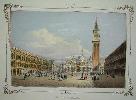
Imprint: Venice, c.1840
23 x 30 cms., early wash colour, with some light foxing on the left margin, some distance from the image
A lovely view of Saint Marks Square in Venice from the 'Album Venitien'
Stock number:3180.
|
|
|
Imprint: London, Chapman & Hall 186, Strand, 1836
Binding: Hardback Inscription: Signed, Inscribed Or Annotated Quarto (270 x 215 mm.), contemporary quarter morocco, cloth boards, ornate gilt title to the upper board, ribbed spine with blind ruled compartments, gilt title, with recent solander box in blue cloth, marbled paper inside, gilt black calf title on spine, light water stain on front cover. With engraved title page, List of Maps and 47 steel engraved maps on 54 sheets all in early wash colour, each accompanied by a leaf of descriptive text with the exception of more for the last few maps, last 4 sheet map of Inland Navigation as one folded and laid on contemporary linen, occasional light foxing, otherwise in good condition.
Sidney Hall (1788?-1831) began his career as an engraver for the Arrowsmith family. Hall was a prolific engraver of the period and according to Worms and Baynton-Williams 'was almost certainly the first engraver to use the new harder steel for map work, using plates manufactured by the Jacob Perkins process as early as 1821'. His first county maps were those published by Samuel Leigh in 1820 in 'Leighs New Picture of England and Wales', a miniature county atlas which proved a success. This series of maps was engraved for John Gorton's 'Topographical Dictionary' issued in parts from 1831-32. The publishers were Chapman and Hall, there is no known familial link between the two Hall's. We cannot conclude for sure that Sidney Hall engraved all of the plates as his will was proved 26 March 1831. The dates on the maps vary between 1830 and 1832. His widow Selina Hall was also an engraver and as she signed hers 'S. Hall' it is difficult to tell. The earliest edition of the maps in an atlas was the British Atlas, first published by Chapman and Hall in 1833. For this the date in the imprints was updated to 1833 and one or two minor alterations made to the plates. The maps are bound alphabetically with those of Yorkshire, Ireland, Scotland and Wales consisting of two plates. A final general map of 'Inland Navigation' backed on cloth is bound at the end with a four-sheet list of canals and railways. As early as 1833 the list records 36 railways, each recording the date of opening. Provenance: with the bookseller's label of 'Jarrold & Sons London Street Norwich' pasted inside front cover as well as the ex Libris of Taylor. Carroll (1996) 94; Chubb (1927) 451; Worms & Baynton-Williams (2011).
Stock number:9942.
|
|
|
Imprint: London, Chapman & Hall 186, Strand, 1836
Edition: First Edition Binding: Hardback Inscription: Signed, Inscribed Or Annotated Quarto (265 x 205 mm.), modern quarter calf, paper boards, spine with gilt ruled compartments and date, gilt calf title, later endpapers, but retaining the original front free one. With engraved title page, List of Maps and 47 steel engraved maps on 54 sheets all in early wash colour, each accompanied by a leaf of descriptive text except for the last few maps with more, last 4 sheet map of Inland Navigation as one folded and laid on contemporary linen, occasional light foxing, otherwise in good condition.
Sidney Hall (1788?-1831) was a prolific engraver of the period and according to Worms and Baynton-Williams 'was almost certainly the first engraver to use the new harder steel plates for map work, using plates manufactured by the Jacob Perkins process as early as 1821'. His first county maps were those published by Samuel Leigh in 1820 in 'Leighâs New Picture of England and Wales', a miniature county atlas which proved a success.This series of maps was engraved for John Gorton's 'Topographical Dictionary' issued in parts from 1831-32 and published by Chapman and Hall. There is no known familial link between the two Hall's. We cannot conclude for sure that Sidney Hall engraved all of the plates, as his will was proved 26 March 1831. The dates on the maps vary between 1830 and 1832. His widow Selina Hall was also an engraver and as she signed hers 'S. Hall', it is difficult to tell. The first edition of the 'New British Atlas' was issued in 1833. An intervening edition was published in 1834. The maps are bound alphabetically with a 4 sheet Inland Navigation. Ireland, Scotland and Wales are in 2 sheets as is that of Yorkshire. These two sheet maps are bound opposing each other for easy reading. The maps are bound in the same order as found in Gortonâs 'Topographical Dictionary' except for England which is bound with Essex. A final general map of 'Inland Navigation' backed on cloth is bound at the end with a four-sheet list of canals and railways. As early as 1833 the list records 36 railways, each recording the date of opening. Provenance: with ownership inscription on front free endpaper of 'G. P. Goldsmith, May 1862'; Doreen Green; Clive A. Burden Ltd. Catalogue 6 (2010) item 44. Carroll (1996) 94; refer Chubb (1927) 454; Worms & Baynton-Williams (2011).
Stock number:10282.
|
|
|
Imprint: London, Chapman and Hall, Strand, 1848
Edition: First Edition Binding: Hardback Inscription: Signed, Inscribed Or Annotated Quarto (205 x 155 mm.), full old cloth, with gilt ruled title to spine, light wear. With typographic title page and 47 steel engraved maps of which 4 are folding, all in early wash colour, light scattered foxing, some light splitting of centrefold, otherwise in good condition.
Sidney Hall (1788?-1831) was a prolific engraver of the period and according to Worms and Baynton-Williams 'was almost certainly the first engraver to use the new harder steel plates for map work, using plates manufactured by the Jacob Perkins process as early as 1821'. His first county maps were those published by Samuel Leigh in 1820 in Leighâs New Picture of England and Wales, a miniature county atlas which proved a success.This series of maps was engraved for John Gorton's Topographical Dictionary issued in parts from 1831-32 and published by Chapman and Hall. There is no known familial link between the two Hall's. We cannot conclude for sure that Sidney Hall engraved all of the plates, as his will was proved 26 March 1831. The dates on the maps vary between 1830 and 1832. His widow Selina Hall was also an engraver and as she signed hers 'S. Hall', it is difficult to tell. The first edition of the New British Atlas was issued in 1833. Ensuing editions appeared in 1834 and 1836. Then it was re-titled A Travelling County Atlas in 1842. The maps here are bound in no identifiable order with those of Yorkshire, Ireland, Scotland and Wales consisting of two plates joined and folded. Carroll (1996) 94; Chubb (1927) 501; Worms & Baynton-Williams (2011).
Stock number:10283.
|
|
Imprint: London, J & J Knapton, 1728
460 x 550 mm., with minor toning to the centrefold, otherwise in good condition.
The Atlas Maritimus & Commercialis from which this chart of the approaches to Bristol was originally proposed in 1719. The maps were to be an improvement on those using Gerard Mercators projection by using a globular one. The atlas is usually attributed to the great Astronomer Royal Edmund Halley who wrote the prefatory note discussing the use of the charts. The author of the first part is believed to be Daniel Defoe, the second including the sailing directions is however the work of Nathanial Cutler. A fascinating detailed chart of the approaches to Bristol. The Somerset shore is detailed from 'Brint' (Brean) to north of the mouth of the Avon. The town of 'Weston Supermare' is also displayed along with 'Cleaven' (Clevedon) and 'Porshut' (Portishead). The Welsh coast is depicted including 'Peterston' near Cardiff and 'Newport'. There is a large amount of detail leading up the Avon River to Bristol. One particular note records 'Here K. W. landed 1690'. Bristol itself is laid out although there is little development south of the river, most of modern day Bedminster recorded as 'Meadow ground'. Shirley (2004) M.Hall 1a no. 11.
Stock number:8137.
|
|
Imprint: c.1840
Inscription: Signed, Inscribed Or Annotated 175 x 270 mm., pencil, black chalk and coloured washes-heightened with white on thick sepia paper, signed J D Harding in the lower left corner, the reverse bears one small area of minor damage due to earlier removal from an album, with no effect to the front, in good condition.
James Duffield Harding (1797 - 1863) was born in Deptford, England and studied with Samuel Prout after whose style this is very reminiscent. Although Harding studied engraving he preferred drawing topography. He exhibited at the Royal Academy at the yound age of 13 years. He was however also a very talented lithographer and produced large folio works by Stanfield and Roberts, for Hullmandel. He travelled to the continent regularly from the 1820s to 40s visiting Italy, Normandy and the Rhine producing various books from his experiences. John Ruskin admired his work and stated that after J M W Turner, Harding was "unquestionably the greatest master of foliage in Europe". This rather fine scene appears to be taken in Italy from the architecture and bears to the left side a boat and path. The verso bears in early manuscript hand 'Yalland', referring to the location or owners name?
Stock number:7323.
|
|
Imprint: London, Printed and sold by D. Midwinter, at the Three Crowns in St Pauls Church-Yard, 1719
Binding: Hardback Folio (405 x 250 mm.), in full contemporary calf, rebacked preserving original spine. Gilt panelled boards, gilt panelled ribbed spine, gilt title, light wear to lower spine. Portrait (laid down) facing Title, Dedication, Preface, Ode to Kent, list of subscribers and index. (4), iv, iv, ii, iv, 592, xl. Illustrated with a large folding engraved map of the county within an ornate heraldic border, with 2 further maps and 39 views (35 double-page) of the noble houses of Kent including a fine panorama of Rochester and Chatham. The main folding map of Kent 565 x 820 mm., 2 sheets joined and laid on linen and loose due to the heavy nature of the map, otherwise in very good condition. The plates of Broome, Rochester and Deane also laid on linen.
Although the title to John Harris' 'History of Kent' refers to five parts it was never to be completed. As it was the work was published posthumously. It is known for being one of the most illustrated of the county histories ever published. The main map itself certainly ranks as one of the best. From an early date Kent has attracted large scale maps with Philip Symonsons large two sheet map dating back to 1596. This map is engraved by Samuel Parker and its borders are decorated with 118 coats of arms of the countys nobility and gentry. The map itself is heavily based on that of Symonson, including roads and the table of hundreds. There are some differences in spelling and some new nomenclature. It bears a fine inset view of Dover Castle and Towne. This is the same view as that of Wenceslaus Hollar on the Symonson map, only it is reversed. This is an example of the third state of the map. Dr. Harris spent eight years making collections for a History of this County; but he did not live to see the fate of his transcripts, as this first volume was published a few months after his death. What progress he had made towards his second volume, which was never published, is not known: but dying insolvent his papers were dispersed; and though every inquiry has been made after them, yet no knowledge has been gained what is become of them (Hasted). Although the book appeared in just the one edition the map is known in three states. They mark a period of the flowering of the classic English Country house and beautifully illustrate the landscape surrounding each one. The book is also known for the prevalence of birds-eye county views of the seats of the country seats by Kip and Badeslade. Provenance: Ivan Deverall; private English collection. Burgess (2009) no. 32.iii; ESTC N7830; Upcott (1968) I pp. 354-57; Worms & Baynton-Williams (2011).
Stock number:7286.
|
|