|
|
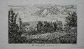
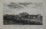
Imprint: London, John Cooke, 1775
175 x 275 mm., in good condition.
This detailed view of Dulwich College appeared in one of the better eighteenth century copperplate view books relating to London. Adams 57 no. 81.
Stock number:7637.
|
|
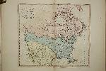
Imprint: London, Sold by all Booksellers, c.1815
Binding: Hardback 440 x 290 mm., full recent calf, ornate blind panelled boards, with ribbed spine, each compartment with double blind ruled lines and central floral blind feature, with red calf gilt title label. With typographic title page in facsimile and 47 double page maps all in early wash colour, in excellent condition.
Donald Hodson, in his work on Hertfordshire county maps, first reported the existence of a 'General and County Atlas' with the series of county maps by John Harrison acquired by the firm of Francis Edwards in September 1967. In this work the last two digits of the imprint date 1788 had been erased. The paper in the atlas was all watermarked with the date 1815, hence his approbation. When David Kingsley published his study on Sussex maps in 1982, he reported that the atlas had been broken up. Fortunately, a further example in beautiful early wash colour appeared at auction in 1997 and we secured it.In this example, the date is erased from all of the imprints to varying degrees of neatness. The atlas is expanded with nine further maps of the world, continents and three general maps of England and Wales, Ireland and Scotland. The title page bears a list of contents although it is incomplete, omitting to list those of Cambridge and Northamptonshire. A further example with this title page was sold at a Phillips auction 15 June 1995 lot 14. However, in that example since broken up, the maps were all in the earlier state with their dates present. No institutional example could be traced, that was the only surviving known example. Then recently we acquired the complete collection of the maps, the only item missing apart from the binding was a title page. All of the contents matched the 1997 example. We have made an excellent facsimile of the title and had the whole rebound to be able to offer only the second known example of this work in beautiful early wash colour.No name appears on the title page although none are removed from the imprints on the maps. Harrison died it is believed in 1812. The will for a John Harrison of Newgate Street survives in the National Archives and is dated 21 May 1812. Harrisons 'Ancient Geography' was re-published by John Hearne if the Strand c.1824. He was active from 1822 to 1860. Not in ESTC; Hodson (1974) 50.iii; Kingsley (1982) no. 54.ii; Tooleys Dictionary (1999-2004).
Stock number:9291.
|
|
|
Imprint: London, Printed by and for John Harrison No. 115, Newgate-Street, 1791
Edition: First Edition Binding: Hardback Oblong folio (405 x 535 mm.), contemporary half calf, marbled paper boards, worn, rebacked ribbed spine, with red calf gilt title affixed, later endpapers. Typographic title page with tissue repairs, pp. (2), viii, with 38 side bound engraved maps, each in early outline colour, facing each other in pairs with interleaved descriptive text facing each map, waterstained throughout, otherwise in good condition.
The FIRST EDITION of John Harrisons 'Maps of the English Counties', this example is side bound. For many years, this series of English County maps was first thought to have been published in the 'Maps of the English Counties' in 1791. Then in 1974 Hodson identified an advertisement in 'The Morning Herald' for 2 May 1787 which stated This day are published, by J. Harrison
Specimens of Maps of the Counties of England and Wales. Hodson believed that they may have been published in Harrisons edition of 'The History of England' by Paul Rapin de Thoyras although he was unable to locate an example. Three examples have since been identified but all are without the full compliment of maps, none are dated beyond July 1790. The last few maps were issued after the event, those of Lincolnshire and Yorkshire were dated 1 February 1791 and Sussex 1 March 1791. That of North and South Wales is dated 26 February 1791. This made up the full complement of 38 maps. There were curiously no general maps of England and Wales or the British Isles despite one of the latter being in Harrisons stock. Early copies not the price on the title pages as 3l. 9s. 6d. Clearly it struggled to sell, this example, that in the British Library and Cambridge University Library examples all have an altered price of 3l. 3s. The price came down further for the second edition the following year at 2l. 2s. Apart from the county descriptions there are eight folio pages of tables to be found at the beginning. Not in Chubb; Carroll (1996) 52, n. 5; ESTC N33259; Hodson (1974) no. 50; Shirley (2004) refer T.Harr 1a & 2a; Tooleys Dictionary (1999-2004); Worms & Baynton-Williams (2011).
Stock number:9783.
|
|
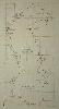
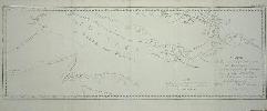
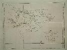
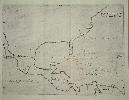
Imprint: London, 1788-[c.1790]
510 x 250 mm., with folds as issued, in good condition.
This map of the Caspian Sea was published by John Harrison in various composite atlases in the late 1780s and early 1790s. It was engraved by Garnet Terry an engraver and jeweller in Cheapside, London. This is an example of the first state lacking his imprint. Shirley 'Atlases in the British Library' T.Har 1a no. 12.
Stock number:5396.
|
|
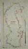
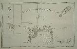
Imprint: London, 16 January 1788
515 x 260 mm., in fine recent outline colour, good condition.
This map of the Caspian Sea was published by John Harrison in various composite atlases in the late 1780s and early 1790s. It was engraved by Garnet Terry an engraver and jeweller in Cheapside, London. This is an example of the second state. Shirley 'Atlases in the British Library' T.Har 1a no. 12.
Stock number:5820.
|
|
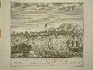
Imprint: London, John Cooke, 1775
175 x 275 mm., with light foxing mostly in the margins, some margin fraying otherwise in good condition.
This detailed view of Acton appeared in one of the better eighteenth century copperplate view books relating to London. Adams 57 no. 75.
Stock number:7635.
|
|

Imprint: London, Hodder and Stoughton, [1869]
Binding: Hardback Quarto (285 x 235 mm.), contemporary red cloth hardboard binding, gilt. With embossed title and pasted on map of the Prussian Empire, light wear. With half title, Introduction, Contents, 12 chromolithographic anthropomorphic caricature maps and 2 leaves of publishers adverts. Contents loose as is often the case, otherwise a nice example.
An atlas of caricature maps reflecting the perspective of a Victorian Britain facing the likes of Garibaldi and Bismark in Europe. The author William Harvey (1796-1873) used the pseudonym 'Aleph'. He was a doctor and active journalist for the City Press who wrote on London and the author of London Scenes and London People published in 1863. In his introduction he writes how the maps were drawn by a fifteen year old girl for the amusement of her sick brother. Her identity has since been identified as Lillian Lancaster, born Eliza Jane Lancaster in 1852 (d.1939) in London. She most likely met Dr. William Harvey through her family in Islington. She went on to the stage as a pantomime artist, comedy actress and singer. The idea apparently came from an earlier drawing of England represented by Punch riding on a dolphin. Their intent was not just entertainment but also educational as the introduction states no history no journal can be understood without acknowledge of maps, and good services is done when we make such information more easy and agreeable. The date of issue is derived from the four page advert bound at the end which includes two items referring to the year 1869. Provenance: private English collection. Barron http://barronmaps.com/lilian-lancaster-1852-1939/; Slowther, Catherine The Map Collector no. 16 pp. 48-50.
Stock number:8734.
|
|
Imprint: London, 1819
Binding: Hardback Inscription: Signed, Inscribed Or Annotated Octavo, contemporary half calf, marbled boards, ornate gilt spine. With 24 hand-colored aquatint plates. A nice clean copy with only one signature displaying light foxing to the text.
Tooley, p. 212; Abbey, Scenery, 30.
Stock number:1709.
|
|
Imprint: Paris, 1774
210 x 630 mm., with folds as issued, in good condition.
This map first appeared in John Hawkesworth's (1715-73) official account of the first circumnavigation of Captain James Cook published in 1773. This issue is from the first French edition published the following year. It depicts the route of Cook past New Guinea and also shows those of Captain Carteret and William Dampier in 1699. Refer Shirley BL G.Hawk 1a no. 14.
Stock number:6403.
|
|
|
Imprint: Paris, 1774
220 x 295 mm. Uncoloured map in excellent condition.
From the French edition of of Hawkesworth's 'Account of the Voyages Undertaken'. Refer Shirley BL G.Hawk 1a no. 6.
Stock number:6295.
|
|
Imprint: London, 1773
185 x 255 mm., in good condition.
This map comes from the official account of the First Voyage of the Pacific by Captain James Cook published in 1773. It records the voyage of Captain Carteret (1766-69) to Pitcairn's Island in the South Pacific. The Island would of course become famous as the home of Fletcher Christian after the mutiny of the Bounty. For the compilation of this work Hawkesworth received £6,000 from the Admiralty Shirley G.Hawk 1a no. 10.
Stock number:4890.
|
|
Imprint: London, 1773
225 x 300 mm., in good condition.
This map of the Falkland Islands comes from the official account of the First Voyage of the Pacific by Captain James Cook published in 1773. It records the voyage of Captain Carteret (1766-69) to the Solomon Islands as they are now called in the South Pacific. For the compilation of this work Hawkesworth received £6,000 from the Admiralty. Shirley G.Hawk 1a no. 6.
Stock number:4892.
|
|
Imprint: London, 1773
205 x 300 mm., in good condition.
Engraved by E. Rooker this view comes from the official account of the First Voyage of the Pacific by Captain James Cook published in 1773. It records a meeting with the natives. For the compilation of this work Hawkesworth received £6,000 from the Admiralty. Shirley G.Hawk 1a.
Stock number:4885.
|
|
Imprint: London, 1773
235 x 385 mm., in good condition.
This map comes from the official account of the First Voyage of the Pacific by Captain James Cook published in 1773. It records the voyage of Captain Carteret (1766-69) to the Solomon Islands as they are now called in the South Pacific. For the compilation of this work Hawkesworth received £6,000 from the Admiralty Shirley G.Hawk 1a no. 11.
Stock number:4883.
|
|
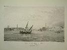
Imprint: London, Smith,Elder & Co, 1833
275 x 415 mm., lithographic plate with only very minor tears to the margin, well away from the image, otherwise in good condition.
"Captain Head describes his purpose in publishing this work as twofold: 'to promote a rapid communication with India by way of Egypt, through the agency of steam navigation, and, as a natural consequence of this measure, to secure our Indian frontier against the perils of northern invasion'." (Blackmer) The work focuses on Egypt. Blackmer sale 673; Blackmer 799; Gay 1846.
Stock number:4422.
|
|
Imprint: Amsterdam, 1698
Binding: Hardback Duodecimo, full contemporary calf, gilt boards bearing arms, raised bands to spine with gilt red calf title label. With 2 engraved folding maps and 2 engraved folding plates in excellent condition. With engraved frontispiece; (70), 313, (8 num 313*), pp. 315-506.
A magnificent example of a highly influential work from the famous noble library of Alexandre de La Rochefoucauld. Following the publication of Louis Hennepins first work, the 'Description de la Louisiane' published in Paris, 1683, there were claims that he usurped the narrative of Robert Cavalier, Sieur La Salle. Hennepin (c.1640-c.1705) was banished from France for reasons unknown and fled to Utrecht about 1687. Indeed Louis XIV later issued an edict ordering his arrest should he arrive at any French port. In 1697 Guillaume Broedelet published Louis Hennepins second work entitled Nouvelle Decouverte
It contained the body of his first work and is updated with a new account inserted before the description of his voyage up the Mississippi River describing his journey down river to the mouth, and back. It is actually drawn from the journal of Father Zenobius Membré as published in the Etablissement de la Roy dans la Nouvelle France by the Jesuit Chrestien Le Clerc in Paris, 1691 and is discounted as entirely fictional by authorities. Hennepin in fact claimed the reverse was the case. One of the views is the first of Niagara Falls. One of the book's chief claims to fame is containing the first illustration of Niagara Falls. Hennepins account of the Upper Mississippi has great significance as he had penetrated further west than any European recorded before him. Thwaites stated that his works were invaluable contributions to the sources of American History; they deserve study, and to this day furnish rare entertainment. We can pardon much to our erratic friar, when he leaves us to such monuments as these. The work was first published in Utrecht the previous year. 'The family of La Rouchefoucauld had been established in the annals of France for over six hundred years ...' (Sotheby's). The library was begun by the sixth Duke, it was later successors who showed a fascination with voyages and travels. Amongst there circle was Benjamin Franklin and Lafayette. In fact it was with the encouragement of Franklin that Jean-Baptiste-Louis-Frederic La Rouchefoucauld produced the first full translation of the American Constitution into French. He had a distinguished political career leading up to the French Revolution. In 1792 he was stoned to death whilst travelling with his wife and mother. A descendant travelled North America and published his account in French and English in 1799. Provenance Sotheby's Monaco 8 December 1987 lot 581. Howes H416; JCB 698/ 103; Sabin 31350.
Stock number:1731.
|
|
|
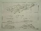
Imprint: London, Henry Teesdale & Co. 302, Holborn, 1 May 1830
1060 x 1115 mm., four sheets, dissected and laid on contemporary linen, edged in green silk, in full early wash colour, marbled endpapers, with full contemporary marbled calf slip case, ornate blind panelled, gilt ruled spine, red calf gilt title label, light wear, otherwise in good condition.
George Hennet (1799-1857) is little known and is identified with only this published map. Eden identifies him as a surveyor of 'road, railway, public works; engineer'. This large scale map of Lancashire was engraved by James Bingley (1796-1869) on the scale of three quarters of an inch to the mile. He engraved a number of items but is probably best known for his contribution to Thomas Moule's 'English Counties Delineated', first published in 1830-35. The Explanation differentiates between woods and plantations, parks, heaths and commons, different types of waterway and road. Both watermills and windmills are identified indicating their significance to the local economy. There are also several railways indicated, the most famous of which was the Liverpool and Manchester Railway opened on 15 September 1830, four months after this was published. It is world famous for being the first passenger railway to rely on locomotives for traction. On that open day the Home Secretary William Huskisson was killed in an accident. The early 1800s was a time of rapid change in the landscape with the burgeoning industrial revolution. A large illustration of the New Custom House, Liverpool, is engraved below the title. The first stone was laid in August 1828 but the building was not finished until 1839. Eden (1979) H298; Rodger (1972) 258; Tooley's Dictionary; Worms & Baynton-William (2011).
Stock number:9845.
|
|
Imprint: Madrid, 1601
215 x 280 mm., in good condition.
In 1601 Antonio de Herrera y Tordesillas published the first four parts of his Historia General. It is usually bound in two volumes; at the end of the second is often found the Descripción de las Indias Occidentalis containing fourteen maps of Spanish possessions, largely in America ... Herrera was the official historian of Castile and the Indies to Philip II of Spain. Considering the dearth of Spanish publications on the New World, particularly cartographic, it is noteworthy that this book had official backing. It details the early exploration of the New World by the Spanish and assembles many documents lost to us today. The geography of the maps is largely derived from the manuscript charts of Juan López de Velasco, c.1575-80. At least four of these have survived; one resides in the John Carter Brown Library, Rhode Island. On this map the most noticeable feature used is the distinctive narrow Florida peninsula. The lack of any great detail still reflects the official policy of protecting Spanish knowledge of the New World; despite this the outline of the maps is accurate. The only name to appear in North America is la florida (Burden). A rare item. Borba de Moraes (1958) vol. 1, p. 336; John Carter Brown Library Annual Report, 1944-45 pp. 12 & 24-5; Burden (1996-2007) 141; Martin & Martin (1984) p. 77; Wagner (1937) pp. 66-7; Wagner (1924) no. 12; World Encompassed (1952) no. 231; Wroth (1944) pp. 158-9, no. 55 and pl. XII (López de Velasco charts).
Stock number:6446.
|
|
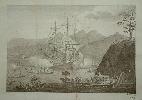
Imprint: Nuremberg, 1744
235 x 265 mm., in good condition.
Johann Wolfgang Heydt's work entitled 'Allerneuester Geographisch und Topographischer Schau-Platz Africa und Ost-Indien' was published in Wilhermsdorf and Nuremburg in 1744 by Johann Carl Teschner and Homann's Heirs. It described the Dutch factories, settlements and stations at the hands of the East India Company. This view is of Cochin (Kochi) on the Malabar cast of south west India. Engraved by Heydt himself it displays the town and fort with a Dutch vessel anchored offshore. Mendelssohn 2 p. 554.
Stock number:6256.
|
|
Imprint: Amsterdam, 1598
145 x 180 mm., in good condition.
Although considered part of the series of miniature Abraham Ortelius atlases this series is distinctly different. They are woodcut productions first and foremost and slightly larger in size. Koeman II p. 132; Shirley 'Atlases in the British Library T.Heyn 1a.
Stock number:5410.
|
|