|
|
|
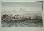
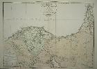
Imprint: Paris, 1830
315 x 415 mm., lithographic print in later wash colour, in good condition.
A lithographic view of New Guinea. It was published in Dumont D'Urville's 'Voyage de la Corvette L'Astrolabe' issued in several parts in 1830. The voyage was searching for the French Admiral and explorer, le Comte de La Pérouse. His voyage ended in tragedy when they were lost after leaving Botany Bay in March 1788. It was not until 1827 that their fate was known, this book marks that finding. Ferguson 1341; Hill p. 88.
Stock number:8620.
|
|
|
Imprint: Paris, 1830
315 x 415 mm., lithographic print in later wash colour, in good condition.
A lithographic view of New Guinea. It was published in Dumont D'Urville's 'Voyage de la Corvette L'Astrolabe' issued in several parts in 1830. The voyage was searching for the French Admiral and explorer, le Comte de La Pérouse. His voyage ended in tragedy when they were lost after leaving Botany Bay in March 1788. It was not until 1827 that their fate was known, this book marks that finding. Ferguson 1341; Hill p. 88.
Stock number:8619.
|
|
|
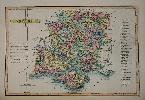
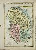
Imprint: London, c.1833
Binding: Hardback Folio (410 x 270 mm.), contemporary half calf, marbled paper boards with gilt ruling and ornate red calf gilt title on upper board, spine with gilt ruled bands, with early manuscript table of contents on inside of upper cover. With double page typographic 'Geographical and Statistical Table', map of England and Wales and a further 43 maps of the counties and Wales bound in geographic order commencing with Sussex, light foxing throughout otherwise in good condition.
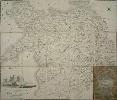
James Duncan is thought to have started as early as 1805 but the 'Complete County Atlas' is his best-known work. Their early history involving William Ebden is complicated and was detailed in David Smiths article. It is believed that Duncan acquired the plates in 1832 and adjusted the titles and added information drawn from the Reform Bill of 1832. First published in 1833 as A New Atlas of England and Wales, the county maps are engraved by Edward Hoare and James Reeves. The maps are derived from those of John Cary. Ensuing editions were entitled A Complete County Atlas and examples are known omitting a title as here. This is an early issue as it lacks any railways. Provenance: bookplate of Rogers, Nottingham in inside front cover; private English collection. Carroll (1996) 85.ii; Chubb (1927) 455; Smith, D. (1991d).
Stock number:9928.
|
|
|
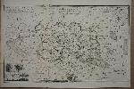
Imprint: London, James Duncan, Paternoster Row, 1838
Binding: Hardback Folio (400 x 260 mm.), modern half red calf done in 1978, marbled paper boards with blind ruling, spine with gilt ruled raised bands, each compartment with ornate floral gilt design, gilt calf title label affixed, with early manuscript table of contents on original front free endpaper, later endpapers. With typographic title, double page typographic 'Geographical and Statistical Table', map of England and Wales and a further 43 maps of the counties and Wales, light offsetting throughout, otherwise in good condition.
James Duncan (fl.1833-45) is thought to have started as early as 1805 but the Complete County Atlas is his best-known work. The maps earlier history involving William Ebden (fl.1811-30), about whom we also know little, is complicated and was detailed in David Smithâs article. At first they were issued loose only, it appears over several years with varying owners. Throughout the series the maps appear to have been uniformly engraved by Edward Hoare (fl.1822-40) and James Reeves (1801?-68). Smith praises the maps stating, âthey are beautifully engraved and their relatively large size, compared to most other county maps of the period, ensures unusually clear depiction of a wide range of features.â There can be no better testimony of his work than the fact that several future series were derived from Ebden. Those in T. Laurie Murrayâs Atlas of the English Counties, 1830, Sidney Hall for the Topographical Dictionary of 1832 and Samuel Lewisâ Topographical Dictionary from 1831.Duncan deleted all reference to Ebden and others and added his own imprint. More importantly he added information drawn from the Reform Act of 1832. All this work indicates that acquisition might have been some time earlier. A general map of England and Wales was added to make a full complement of 44 maps (Yorkshire being in two sheets). The general map records in black boxes the number of county members being returned to Parliament. The maps are arranged by Circuits, six for England and two for Wales. The order is laid out in the double page statistical sheet following the title and commences with Sussex. This unusual format may explain why in this example a manuscript Index was written. None of the maps yet refer to railways except for Durham which specifically says at the end of the title âWith the Several Railwaysâ. The title records the price for the atlas at 2 guineas plain as here and four guineas coloured. This example is dated 1838 but two earlier issues are known: undated in 1835 and dated 1837. Provenance: bookplate of Rogers, Nottingham in inside front cover; private English collection. Carroll (1996) 85; refer Chubb (1927) 455; Smith, D. (1991).
Stock number:10284.
|
|
Imprint: Paris, c.1855
310 x 420 mm., in fine modern wash colour, with publishers blind stamp below, in good condition.
Jean Baptiste Henri Durand-Brager (1814-79) served in the Navy whilst at the same time being a maritime artist. He served under Vice-Admiral Hamelin in the Crimean War. He also acted as War Correspondent for several French newspapers during the conflict. He also produced a noted series of twenty pictures forming a panorama of the attack on Sevastapol which are in the museum at Versailles. This fine lithographic view is from his rare work entitled 'Voyage dans la Mer Noire, le Bosphore, la Mer de Marmara & les Dardanelles', published c.1855. Blackmer 520.
Stock number:5918.
|
|
Imprint: Vienna, c.1700
Inscription: Signed, Inscribed Or Annotated 170 x 255 mm., in good condition.
An uncommon prospect of London from south of the River Thames. It is signed by J. Eder as engraver. Tooley's Dictionary records a Johann Eder as having produced a prospect of Warsaw dated 1700. A slightly more fanciful image than most displaying an unusual dome of St. Pauls and an embankment running the full extent of the north shore. The Tower of London is seen on the right with London Bridge in the foreground. Prominent in the background is the Monument opened in 1677 to commemorate the Great Fire of London in 1666. The image was drawn by A. Sommer. Tooley's Dictionary.
Stock number:8669.
|
|
|
Imprint: London, For the Author, No. 23, Belvidere Place, St. George, Southwark, 1801
Binding: Hardback Folio (290 x 240 mm.), nineteenth century half red calf, marbled paper boards, gilt ruled, gilt title to the spine, marbled endpapers, light wear. With typographic title page, List of Subscribers, Companion in 2 parts, Description, pp. xiii, 16, 86, 24, with 6 copperplates, 9 double page detailed maps and 5 further maps, light water staining, otherwise in good condition.
This very rare work appears to vary in collation from one example to the next. We first note James Edwards (fl.1787-1820) in 1787 when he began producing maps and plates. He was a surveyor, engraver and publisher who started out in Dorking, Surrey. He focused on local material relating to Surrey, Sussex and Kent. The bibliography of this book is complicated. The first clear evidence for the project appeared in January 1788, when William Bray described it as âa work which he is now publishing in numbers, being a map and description of the road from London to Brighthelmstone, taking in a good deal of the adjacent countryâ (Archaeologia 9 (1789) p. 106). It appears that it can consist of three different publications. A Companion from London to Brighthelmston, the Description of Southwark, Lambeth, Newington ⦠and sometimes the Tabulae Distantiae, 1789. The Companion is made up of two Parts, the first according to Upcott should consist of 32 pages. Both are present here as is the Description of Southwark ⦠The Tabulae Distantiae however is omitted. The whole is completed by a six-page list of subscribers including many notable individuals such as Sir Joseph Banks. The plate collation is even more varied. The âsetâ of 9 numbered plates of the route from London to Brighton appear to lack number 4. These are all orientated to the east and are variously dated between 1787 and 1800. Where identified the engraver is Edwards himself. These are supplemented with plans of South London, Lewes and New Shoreham. The title page doubled as an advertisement for the work, and calls for an additional section: Tabulae Distantiarum, not present in this copy. The detail of that found on the roads is truly amazing. Page 11 of the second part describes the home of Henry Cavendish, the scientist, on Clapham Common as âthe seat of Hon. Henry Cavendish. It is a tolerable good house, built with red brick. In a paddock at the back of the house is a mast of a ship, erected for the purpose of making philosophical experimentsâ. The figures in the columns to the left side give the exact distances which Edwards gives for each property. This gives the distance from London, in miles, quarter-miles and rods. A rod is 5½ yards and there are 320 rods in a mile, making 80 in a quarter-mile. The miles are recorded in roman numerals, with Arabic recording the quarter-miles and rods.Provenance: bookplate of Sir George Warren, K.B. (1735-1801) pasted inside front cover; Phillips Auctions 14 May 1992 lot 197; private English collection. Fordham (1924) p. 45; Giles, Phyllis The Last of the Warrens: Sir George Warren, K.B. (1735-1801); Kingsley (1982) App. VII no. 3; Tooleyâs Dictionary (1999-2004); Upcott (1978) pp. 1217-9; Worms & Baynton-Williams (2011).
Stock number:10425.
|
|
Imprint: Prague, 1806-[11]
415 x 305 mm., early outline colour, with folds as issued in very good condition.
This map of the south west coast of Africa extends from the equator south to 25 degrees and takes in Equatorial Guinea and Gabon to Namibia. The map is centred on Angola and the Congo. and was first published by the Weimar Geographische Institut in Vienna 1806. This state comes from the two volume "Neuste kunde von Afrika" published in Prague, 1811, by Diesbach. Tooley's Dictionary.
Stock number:7432.
|
|
Imprint: London, [1819]
Binding: Hardback Quarto (310 x 245 mm.), old cloth binding retaining original morocco gilt label priced "L3 3s 0D", light wear and staining to lower portion. With engraved title, and 42 engraved maps by James Wallis all in early wash colour, pp. (2), 2, (26), descriptive text accompanying each map, (14). Wiltshire with light paper adhesion, otherwise in good condition.
In 1812 James Wallis (fl.1810-25) published "Wallis's New British Atlas', the largest of three county atlases he produced. The maps are derived from the George Cole and John Roper "British Atlas" of 1810. Wallis did however claim that they were engraved in a "superior manner". Wallis was an engraver and publisher and went bankrupt twice, in 1801 and again in 1805. The county maps of Cornwall, Devon, Somerset, Cheshire, Hunts., Northants., Sussex, Westmoreland and that of South Wales all bear the imprint of L. Herbert as geographer. This atlas is a re-issue by George Ellis dated to 1 July 1819 from the Preface. Although Wallis's name is retained on the maps all of the other imprints below the maps have been removed with the usual exception of Lancashire and Warwickshire. B atten & Bennett (1996) no. 78.3; Chubb 367; Tooley's Dictionary.
Stock number:7485.
|
|
Imprint: London, G. Ellis, No. 5. Smith's Square, Westminster, [1819]
Binding: Hardback Quarto (305 x 240 mm.), later green morocco half calf, paper boards, preserving original marbled paper boards and retaining original morocco gilt label priced 'L3. 3s. 0D.'. With engraved title, 45 maps, comprising a general map of England and Wales, 42 engraved maps of the English counties and maps of North and South Wales, all in early wash colour, pp. (2), 2, (24), a leaf of descriptive text accompanies each map, (14). That of Cambridgeshire bound upside down, otherwise In good condition.
In 1812 James Wallis (fl.1810-25) published "Wallis's New British Atlas', the largest of three county atlases he produced. He was born it is believed in Southampton in 1784. He was apprenticed to John Roper in 1799 and freed on 5 February 1811. It appears he started out as an engraver becoming a bookseller, printer, stationer and publisher. The maps are derived from the George Cole and John Roper 'British Atlas' of 1810, themselves derived from John Cary. Wallis did however claim that they were engraved in a 'superior manner'. They were produced for Samuel Augustus Oddy whose publishing career appears to have been short. There was a later edition by Wallis himself c.1814. By 1819 the plates were in the hands of George Ellis whose 'New and Correct Atlas of England and Wales' was published in that year. Although Wallis's name is retained on the maps all of the other imprints below the maps have been removed with the usual exception of Lancashire and Warwickshire. Those of Berkshire, Cornwall and Lancashire have above them 'Second Edition with Considerable Improvements and Additions, by G. Hebert, Geographer'.
The other notable difference is the lack of a general map of England and Wales. None is called for in the Contents and in all but one other example noted, none exists. This example however is supplied with one. It is not the previous Wallis plate which had always required a fold to fit. Here a new unsigned plate of similar size to the county maps is placed before the title. Provenance: with old IHS library stamp to title page; bookplate of Reverend Bernard James Addis affixed inside front cover; Burden Collection duplicate acquired pre-1975. Batten & Bennett (1996) no. 78.3; Chubb (1927) 367; Tooley's Dictionary (1999-2004); Worms & Baynton-Williams (2011).
Stock number:9295.
|
|
|
Imprint: London, G. Ellis, No. 5. Smith's Square, Westminster, [1819]
Binding: Hardback Small folio (300 x 235 mm.), modern quarter cloth, marbled paper boards, retaining publisher's morocco calf gilt label priced 'L2. 12s. 6D.'. With engraved title and 45 engraved maps, comprising a general map of England and Wales opposite engraved title, 42 engraved maps of the English counties and maps of North and South Wales, all in early wash colour, a leaf of descriptive text accompanies each map, pp. 2, (26), (14), in good condition.
In 1812 James Wallis (fl.1810-25) published Wallis's New British Atlas, the largest of three county atlases he produced. It is believed he was born in Southampton in 1784. He was apprenticed to John Roper in 1799 and freed on 5 February 1811. He started out as an engraver becoming a bookseller, printer, stationer and publisher. The maps are derived from those from George Cole and John Roper's British Atlas of 1810, themselves derived from John Cary. Wallis did however claim that they were engraved in a 'superior manner'. They were produced for Samuel Augustus Oddy whose publishing career appears to have been short. There was a later edition by Wallis himself c.1814. By 1819 the plates were in the hands of George Ellis whose New and Correct Atlas of England and Wales offered here, was published in that year. Although Wallis's name is retained on the maps as engraver, all of the imprints below the maps have been removed with the usual exception of Lancashire and Warwickshire. Those of Berkshire, Cornwall and Lancashire have above them 'Second Edition with Considerable Improvements and Additions, by G. Hebert, Geographer'. In earlier examples of this work the label on the cover includes a higher price. Here it is reduced from 3L.3s.0d to âL2.I2.6.â Provenance: inscription of Gertrude J. Coles on original front free endpaper. Batten & Bennett (1996) no. 78; Chubb (1927) 367; Tooley's Dictionary (1999-2004); Worms & Baynton-Williams (2011).
Stock number:10245.
|
|
Imprint: London, c.1766
235 x 395 mm., with folds as issued, otherwise in good condition.
From 'Ellis's English Atlas' by John Ellis (fl.1750 d.1796) which was engraved in the style of Thomas Kitchin as seen in the latter's 'England Illustrated' of 1764. Ellis' work was first published in around 1765 as the 'New English Atlas' which survives in just the one known example. Those plates which bear no engravers imprint are accepted to be engraved by him in this example of the Channel Islands. Hodson no. 238; Kingsley 44.
Stock number:5743.
|
|
Imprint: London, c.1760
240 x 385 mm., with folds as issued, in good condition.
Joseph Ellis (fl.1750-d.1796) was an engraver whose most important cartographic production was the atlas named after him of the English Counties. It was first published in 1765 as the 'New English Atlas' of which only one incomplete example survives. The plates were engraved in the style of Thomas Kitchin as seen in the latter's 'England Illustrated' of 1764. Those plates which bear no engravers imprint are accepted to be engraved by him including this example of the Channel Islands. Hodson no. 238; Kingsley 44.
Stock number:7735.
|
|
Imprint: London, Admiralty Office, 1876-[83]
495 x 650 mm., with fine recent wash colour, with some light toning to the paper, otherwise in good condition.
A superb detailed plan of the coast of southern France centred on Nice and Villefranche-sur-Mare. The city of Nice is encircled by the Marseille to Italy railway. The city is yet to spread out to this point. All the streets and the buildings are carefully placed. The major buildings including notably the hotels are all identified. To the east is the town of 'Ville Franche' which had only recently been returned to France from the Kingdom of Sardinia in 1860. At this point it was becoming an important Russian Naval Base due to its deep water port. The even less developed Beaulieu to the east is shown with only a small number of buildings. Saint-Jean-Cap-Ferrat bears only the one road with a branch leading to the town. Overall a fascinating map of the region surveyed by Captain F. J Evans, first published in 1876 and hear bearing the fifty update in 1883.
Stock number:7741.
|
|
Imprint: London, 1797
Edition: First Edition Inscription: Signed, Inscribed Or Annotated 620 x 730 mm. Dissected and laid on linen, folding into the original marbled slipcase, with contemporary label inscribed by the owner Dawson, worn. A couple of minor marks to the map but generally a fine copy.
FIRST EDITION. Engraved by Robert Baugh this is a reduction of John Evans wall map on 9 sheets. About Evans there was always some confusion. There are according to Iolo and Menai Roberts a total of six John Evans involved in cartography, five of them are Welsh! His article helped significantly to separate their respective works. A John Evans (1723-95) is from Llwynygroes, an estate near the village of Llanymynech near the Montgomery-Shropshire border. His nine sheet map of North Wales was published in June 1795 and was also engraved by Robert Baugh. It is the largest map to be published of North Wales prior to the Ordnance Survey. Evans also produced a manuscript of a reduced version but he died before it was published. This was achieved at the hands of his son, also John Evans (1756-1846). This John Evans was a doctor in Shrewsbury and after inheriting the estate moved there to live. In this reduction the view of Vale Crucis Abbey found on the original is changed to one of Conway Castle. Dr. Evans submitted both maps to the Royal Society of Arts for an award and in 1802 received the sum of 45 guineas. A second edition of the reduction was published in August 1802 which included the addition below the scale of miles of an explanation of turnpike roads, crossroads and intended roads. Some of these were new additions to the map itself. This is an example of the first edition. Provenance: manuscript ownership inscription to one of the labels of Mrs Dawson; public auction. Roberts Which John Evans, in The Map Collector no. 46, pp. 18-23; Rodger 584.
Stock number:4255.
|
|
Imprint: Dublin, 1750
175 x 200 mm., in good condition.
Edward Exshaw began publishing the Dublin edition of the 'London Magazine' in 1741. He was joined by his son John in 1745 and upon Edward's death in 1748 his second wife, Sarah, joined the partnership. The map of Surrey was published in March 1750, the same month in which the London edition was issued. A very rare map. Hodson (1984-97) II Appendix I no. 2 pp. 175-9.
Stock number:9320.
|
|
Imprint: London, c.1714
260 x 205 mm., mezzotint engraving, trimmed and laid down on large paper, otherwise in good condition.
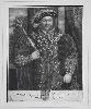
An impressive three-quarter length portrait of Henry VIII (1491-1547). This is one of forty five plates engraved by John Faber Senior (c.1660-1721) for his work on the 'Founders of Oxford and Cambridge Colleges, the Royal Exchange and Charterhouse'. The King is illustrated as founder of Christ Church This is an example of the numbered state, 6 being in the lower right corner. Faber was born at the Hague and came to England with his son of the same name either c.1687 or 1695. He established a shop in the Strand near the Savoy in 1707. Chaloner Smith 34; McKenzie 'British Prints' p. 154; O'Donoghue 12.
Stock number:8297.
|
|
Imprint: Rome, c.1760
240 x 370 mm., with folds as issued, in good condition.
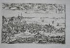
A very attractive detailed birds-eye view of Nice in southern France. It depicts the old town and harbour with the Citadel in the background.
Stock number:7804.
|
|
Imprint: London, 1802
570 x 810 mm., early wash colour, light browning to parts of the centrefold and edge of lower margin, otherwise in good condition.
A very large scale map of Lower Egypt published by William Faden, one of the most successful publishers of the last quarter of the eighteenth century. It appeared in the later editions of William Faden's 'General Atlas'. The ever growing threat of General Napoleon Bonaparte at the close of the eighteenth century had the idea of threatening the British position in India by invading and conquering Egypt and thereby controlling access through the Middle East. The expedition famously included a cultural part with many scientists, educators, and technical specialists. It included a surveying party to judge the feasibility of cutting a ship-canal between the Red and Mediterranean Seas. About three weeks after his landing a British fleet of 14 ships under Horatio Nelson, which had been scouring the western Mediterranean Sea looking for the French fleet, finally came upon the 15 French ships being used to support the invasion of Egypt. The 'Battle of the Nile or Aboukir Bay' (August 1-2, 1798) saw the British fleet under Rear-Admiral Nelson defeat a French fleet, stranding Napoleon's army in Egypt. French losses have been estimated to have been as high as 1,700 dead (including Vice-Admiral Brueys) and 3,000 captured. British losses were just 218 dead. The battle established British naval superiority during the remainder of the French Revolutionary Wars, and was an important contribution to the growing fame of Admiral Nelson. The Egyptian city of Alexandria figured prominently in the military operations of Napoleon's expedition of 1798. The French troops stormed the city on the July 2, 1798, and it remained in their hands until the arrival of the British expedition of 1801. The Battle of Alexandria, fought on March 21 that year, between the French army under General Menou and the British expeditionary corps under Sir Ralph Abercrombie, took place near the ruins of Nicopolis, on the narrow spit of land between the sea and Lake Abukir, along which the British troops had advanced towards Alexandria after the actions of Abukir on March 8 and Mandora on March 13. The British subsequently advanced upon Alexandria, which surrendered on 2 September 1801 (Wikipedia).
Stock number:4929.
|
|
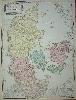
Imprint: London, 1790
730 x 540 mm., in lovely early wash colour, very good condition.
A good large scale map of Denmark with superb detail of including roads, reefs and ferry routes. It is decorated with a handsome title cartouche and scale of miles. Published by William Faden, one of the most successful publishers of the last quarter of the eighteenth century, it appeared in the 'General Atlas'.
Stock number:5360.
|
|