|
|
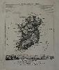
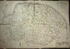
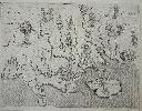
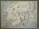
Imprint: London, Bowles & Carver No. 69 St Paul's Church Yard, c.1795-[c.1830]
205 x 165 mm., small tear in the lower left margin repaired, watermarked Whatman 1830, otherwise in good condition.
This is a desirable caricature map of Ireland by Robert Dighton (1752-1814), a well known eighteenth century painter of portraits and caricatures. Initially he often worked anonymously for Carington Bowles. In the 1790s his series of caricature portraits earned him praise. He achieved notoriety however when he took some Rembrandt engravings from the British Museum and replaced them with copies. They were all located in his rooms and returned. The date of issue is unknown but the first catalogue in which they appear is dated to 1795. It was advertised at 6d plain as here or 1s coloured. Feaver (1988) p. 60; Hill (1978) pp. 44-5; Mackenzie (1998) p. 143.
Stock number:7357.
|
|
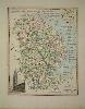
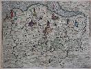
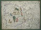
Imprint: London, 1822.
44 x 35 cms., in lovely early wash colour. Excellent condition.
The maps for this very rare atlas were issued separately first then bound together as 'A Complete Atlas of the English Counties'. The work was begun by Thomas Dix but had to be completed by William Darton. Dix (c.1769-1813) worked as a surveyor and is recorded working in this county, Norfolk. Darton, father and son, were both called William. They were active publishers in London at the time and are to be credited for completing this wonderful rare work. Carroll 75.i; Chubb 387.
Stock number:3893.
|
|
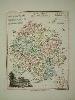
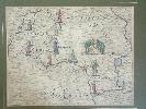
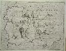
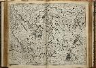
Imprint: London, 1822.
44 x 35 cms., in lovely early wash colour. Excellent condition.
The maps for this very rare atlas were issued separately first then bound together as 'A Complete Atlas of the English Counties'. The work was begun by Thomas Dix but had to be completed by William Darton. Dix (c.1769-1813) worked as a surveyor and is recorded working in this county, Norfolk. Darton, father and son, were both called William. They were active publishers in London at the time and are to be credited for completing this wonderful rare work. Chubb 387.
Stock number:3892.
|
|
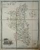
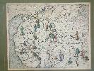
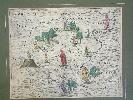
Imprint: London, 1822
440 x 350 mm., in early outline colour, cut and dissected, mounted on early linen. Slight browning lower right corner, otherwise in decent condition.
The maps for this very rare atlas were issued separately first then bound together as 'A Complete Atlas of the English Counties'. The work was begun by Thomas Dix but had to be completed by William Darton. Dix (c.1769-1813) worked as a surveyor and is recorded working in Norfolk. Darton, father and son, were both called William. They were active publishers in London at the time and are to be credited for completing this wonderful rare work. Chubb 387.
Stock number:4276.
|
|
|
Imprint: London, Printed for R. and J. Dodsley, in Pall-mall, 1763[64]
Quarto, two volumes (290 x 230 mm. each), full contemporary calf, rebacked, spines with decorative gilt ruled compartments, gilt calf title and volume number labels. With typographic title page, Preface, Contents, Introduction, pp. (8), xiii, blank, 426; typographic title page, Contents, pp. (4), 490, with two general folding maps, 52 engraved county maps, all by Thomas Kitchin and all in early outline colour, 39 engraved town views and numerous other engravings set in the text, complete with blank endpapers, some offsetting from maps to text second folding map wrinkled, otherwise a good example.
An EARLY OUTLINE COLOURED example. Thomas Kitchin (1718-84) was one of the most notable English cartographers of the eighteenth century. He was both an engraver and publisher of considerable reputation who was made Hydrographer to King George III. He worked with many of his contemporaries on various projects. In late October 1763 Robert (1703-64) and James Dodsley announced the publication of the two-volume 'England Illustrated' utilising 54 maps engraved by Kitchin. Each map was accompanied by descriptive text of the county with engravings by others. The maps give remarkable detail of major roads, each having a decorative cartouche. The atlas appeared on time being advertised as available on the 1 December 1763. A total of 1000 copies were printed. The same maps were re-issued in 1765 by James Dodsley as 'Kitchen�s English Atlas', a very rare work. Robert Dodsley died on 23 September 1764, he was a successful writer, poet and publisher before moving into cartographic items. His first contribution was John Cowley�s 'Geography of England', 1744. Provenance: bookplates to both volumes of Myles Storr Nigel Kennedy (1889-1964), barrister, army officer and politician; private English collection. Beresiner pp. 98-9; Chubb 224; Hodson 231; Shirley BL T.Kit 3a.
Stock number:9908.
|
|
|
Imprint: London, Printed for R. and J. Dodsley, in Pall-mall, 1763[64]
Quarto, two volumes (290 x 225 mm. each), full contemporary speckled calf, ribbed spines gilt ruled with decorative gilt central features, gilt red calf title labels. With typographic title page, Preface, Contents, Introduction, pp. (8), xiii, blank, 426; typographic title page, Contents, pp. (4), 490, with two general folding maps, 52 engraved county maps, all by Thomas Kitchin, 39 engraved town views and numerous other engravings set in the text, complete with blank endpapers, some offsetting from maps to text second folding map wrinkled, B2 in the first volume not fully bound, otherwise a good example.
Thomas Kitchin (1718-84) was one of the most notable English cartographers of the eighteenth century. He was both an engraver and publisher of considerable reputation who was made Hydrographer to King George III. He worked with many of his contemporaries on various projects. In late October 1763 Robert (1703-64) and James Dodsley announced the publication of the two-volume 'England Illustrated' utilising 54 maps engraved by Kitchin. Each map was accompanied by descriptive text of the county and engravings by others. The maps give remarkable detail of major roads, each having a decorative cartouche. The atlas appeared on time being advertised as available on the 1 December 1763. A total of 1000 copies were printed. The same maps were re-issued in 1765 by James Dodsley as 'Kitchen’s English Atlas', a very rare work. Robert Dodsley died on 23 September 1764, he was a successful writer, poet and publisher before moving into cartographic items. His first contribution was John Cowley’s 'Geography of England', 1744. Provenance: manuscript notation inside upper board of both volumes 'A Present from Mr. Norris to Richard Franklyn, Junior. 1802', with accompanying bookplate for Franklyn; private English collection. Beresiner (1983) pp. 98-9; Chubb (1927) 224; Hodson (1984-97) 231; Shirley (2004) T.Kit 3a.
Stock number:10175.
|
|
Imprint: London, William Faden, 12 August 1797
1220 x 1840 mm., in 4 sections each labelled, in early outline colour, dissected and laid on linen, with silk edges, folding into the publisher William Faden�s original slipcase, lightly worn. The map is in good condition.
William Faden began by working for the firm of Thomas Jefferys, quite probably after the latter�s death in 1771. In 1783 he took control. He was an active publisher who pursued the same interest as his predecessor in fresh surveying. Many fine maps and charts were published by Faden. Norfolk did not have a published map to the scale of one inch to the mile. Andrew Armstrong had moved to the county and proposed one of Norfolk and of the neighbouring county of Cambridgeshire, however neither came to fruition. Faden had employed the services of Thomas Milne to survey Hampshire which was published in 1791. He invited him to work for him again, this time on Norfolk. Here he was joined by Thomas Donald who had worked with Jefferys on surveys of Bedfordshire, Buckinghamshire, Cumberland and Yorkshire. The project took five years to complete; the result of which was well engraved on six sheets. Although lacking the more decorative title cartouche familiar in the earlier part of the century it is more than made up for by the fine town plans of Kings Lynn, Swaffham and Great Yarmouth. The map as expected at this scale bears great detail with the names of owners of individual estates. Faden was proud enough of the map to apply to the Royal Society of Arts for an award but failed. He had already won awards for his maps of Sussex and Hampshire. This map first published in 1797 was twice updated in quick succession notably with an additional 19 line note to the right of the plan of Kings Lynn as here. A later fourth state was published. Chubb (1928) p. 78; Frostick Norfolk 61.3; Rodger (1972) no. 346.
Stock number:6285.
|
|
|
Imprint: London, 1838
210 x 485 mm., early outline colour, backed on contemporary linen, with publishers folds, in good condition.
This map illustrates the route of the London to Birmingham Railway. The Railway was incorporated on 6 May 1833 with a proposed route of 112.5 miles. The first section was not opened however until 20 July 1837 when the section to Boxmoor was unveiled. A gradient profile is illustrated along the bottom. The inset upper right depicts the London terminus at Euston Grove. A fascinating document illustrating to the public the surrounding country to the line. Several miles either side are depicted. One can imagine the objections at the time. Robert Stephenson (1803-59) was the chief engineer on the London to Birmingham line. This map is believed to have been published in 1838 and accompanied 'Drake’s Road Book of the London and Birmingham Railway', 1839, it was the main illustration in the work. The map is the work of J. B. Wallace and engraved by James Archer. James (1983) A Chronology of the construction of Britain's Railways 1778-1855'.
Stock number:10439.
|
|
Imprint: London, 1622
250 x 335 mm., in fine modern wash colour, with extended lower right corner margin, not affecting the image, otherwise in good condition.
From the �Poly-Olbion� as it is more commonly known, a book of poems by the Elizabethan poet Michael Drayton (1563-1631). He was born in 1563 at Hartshill, near Atherstone, Warwickshire. He began working on his longest poem at least 14 years before publication in 1612. It comprises a series of songs in praise of the English and Welsh countryside, with accompanying allegorical maps. The 1622 issue is the first complete edition, containing all thirty sections, each with a highly attractive engraved map. The notes to the songs were written by the polymath John Selden. The newly engraved maps for the second book also contain page numbers engraved near the upper margin and are therefore found in only one state. The new maps as stated in the title to the second part cover the area �betwixt the two famous Riuers of Thames, and Tweed�.Yates argues that the �Poly-Olbion� was one of the most important attempts during the Stuart era to connect them with Tudor myth of �British� history. This is best seen in the allegorical title page which displays both the Stuarts and the Tudors as descendants of Brut. It depicts a virginal Albion wrapped in a cloak resembling a map of England. The symbolism suggests that the descriptive �maps� in the work have a serious historical context. Yates asserts that the graceful nymphs displayed on many of the maps recalls the masque of the Tethys Festival given at court in June 1610 on the occasion of the creation of Henry as Prince of Wales. Drayton died 23 December 1631 and is buried in Westminster Abbey. This map is one of those published in the expanded edition of 1622 only which extended the coverage further north and east. It covers Bedfordshire, Huntingdonshire and Cambridgeshire. Carroll (1996) 8; Chambers I; Chubb (1927) 35; Harley �Tudor Mapmaking�; Hodson (1974) Supp I.ii; Kingsley (1982) IV 1.ii,3; Shirley (2004) T.DRA-1d; Skelton (1970) 13; STC 7228-30; Yates (1975).
Stock number:5944.
|
|
Imprint: London, 1622
250 x 335 mm., in fine modern wash colour, in good condition.
From the �Poly-Olbion� as it is more commonly known, a book of poems by the Elizabethan poet Michael Drayton (1563-1631). He was born in 1563 at Hartshill, near Atherstone, Warwickshire. He began working on his longest poem at least 14 years before publication in 1612. It comprises a series of songs in praise of the English and Welsh countryside, with accompanying allegorical maps. The 1622 issue is the first complete edition, containing all thirty sections, each with a highly attractive engraved map. The notes to the songs were written by the polymath John Selden. The newly engraved maps for the second book also contain page numbers engraved near the upper margin and are therefore found in only one state. The new maps as stated in the title to the second part cover the area �betwixt the two famous Riuers of Thames, and Tweed�.Yates argues that the �Poly-Olbion� was one of the most important attempts during the Stuart era to connect them with Tudor myth of �British� history. This is best seen in the allegorical title page which displays both the Stuarts and the Tudors as descendants of Brut. It depicts a virginal Albion wrapped in a cloak resembling a map of England. The symbolism suggests that the descriptive �maps� in the work have a serious historical context. Yates asserts that the graceful nymphs displayed on many of the maps recalls the masque of the Tethys Festival given at court in June 1610 on the occasion of the creation of Henry as Prince of Wales. Drayton died 23 December 1631 and is buried in Westminster Abbey. This map is one of those published in the expanded edition of 1622 only which extended the coverage further north and east. It covers Cumberland and Westmoreland which features the Lake District. Carroll (1996) 8; Chubb (1927) 35; Harley �Tudor Mapmaking�; Higham p. 18; Hodson (1974) Supp I.ii; Kingsley (1982) IV 1.ii,3; Shirley (2004) T.DRA-1d; Skelton (1970) 13; STC 7228-30; Yates (1975).
Stock number:5950.
|
|
Imprint: London, 1612
250 x 335 mm., in fine modern wash colour, in good condition
From the 'Poly-Olbion' by Michael Drayton (1563-1631). Drayton began writing his longest poem in 1598, it was first published in 1612. It comprises a series of songs in praise of the English and Welsh countryside and was accompanied by a set of desirable allegorical maps. This is an example of the second state issued in the first complete edition in 1613 with the addition of a page number at the upper edge. Booth pp. 35-7; Skelton no. 8.
Stock number:9025.
|
|
Imprint: London, 1612-[13]
250 x 330 mm., cut close lower right side with no apparent loss to image.
From the 'Poly-Olbion' by Michael Drayton (1563-1631). Drayton began writing his longest poem in 1598, it was first published in 1612. It comprises a series of songs in praise of the English and Welsh countryside and was accompanied by a series of desirable allegorical maps. This is an example of the second state included in the second edition of 1613 with the addition of a page number in the upper margin. It covers the area of Lyme Regis in the west to Portsmouth in the east. Recognisable names include Hamble, Itchin, the New Forest and The Poole. Beaton pp. 20-21; Skelton no. 8.
Stock number:5603.
|
|
Imprint: London, 1612-[13]
250 x 330 mm., a truly perfect example.
From the �Poly-Olbion� as it is more commonly known, a book of poems by the Elizabethan poet Michael Drayton (1563-1631). He was born in 1563 at Hartshill, near Atherstone, Warwickshire. He began working on his longest poem at least 14 years before publication in 1612. It comprises a series of songs in praise of the English and Welsh countryside, with accompanying allegorical maps. The 1622 issue is the first complete edition, containing all thirty sections, each with a highly attractive engraved map. The notes to the songs were written by the polymath John Selden. The newly engraved maps for the second book also contain page numbers engraved near the upper margin and are therefore found in only one state. The new maps as stated in the title to the second part cover the area �betwixt the two famous Riuers of Thames, and Tweed�.Yates argues that the �Poly-Olbion� was one of the most important attempts during the Stuart era to connect them with Tudor myth of �British� history. This is best seen in the allegorical title page which displays both the Stuarts and the Tudors as descendants of Brut. It depicts a virginal Albion wrapped in a cloak resembling a map of England. The symbolism suggests that the descriptive �maps� in the work have a serious historical context. Yates asserts that the graceful nymphs displayed on many of the maps recalls the masque of the Tethys Festival given at court in June 1610 on the occasion of the creation of Henry as Prince of Wales. Drayton died 23 December 1631 and is buried in Westminster Abbey. This is an example of the second state included in the second edition of 1613 with the addition of a page number in the upper margin. It covers effectively the counties to the north of the Thames including Middlesex and Hertfordshire. Carroll (1996) 8; Chubb (1927) 35; Harley �Tudor Mapmaking�; Hodson App. I no. 1.ii; Kingsley (1982) IV 1.ii,3; Shirley (2004) T.DRA-1d; Skelton (1970) 8; STC 7228-30; Yates (1975).
Stock number:3479.
|
|
Imprint: London, 1612
250 x 335 mm., in fine modern wash colour, in good condition.
From the �Poly-Olbion� as it is more commonly known, a book of poems by the Elizabethan poet Michael Drayton (1563-1631). He was born in 1563 at Hartshill, near Atherstone, Warwickshire. He began working on his longest poem at least 14 years before publication in 1612. It comprises a series of songs in praise of the English and Welsh countryside, with accompanying allegorical maps. The 1622 issue is the first complete edition, containing all thirty sections, each with a highly attractive engraved map. The notes to the songs were written by the polymath John Selden. The newly engraved maps for the second book also contain page numbers engraved near the upper margin and are therefore found in only one state. The new maps as stated in the title to the second part cover the area �betwixt the two famous Riuers of Thames, and Tweed�.Yates argues that the �Poly-Olbion� was one of the most important attempts during the Stuart era to connect them with Tudor myth of �British� history. This is best seen in the allegorical title page which displays both the Stuarts and the Tudors as descendants of Brut. It depicts a virginal Albion wrapped in a cloak resembling a map of England. The symbolism suggests that the descriptive �maps� in the work have a serious historical context. Yates asserts that the graceful nymphs displayed on many of the maps recalls the masque of the Tethys Festival given at court in June 1610 on the occasion of the creation of Henry as Prince of Wales. Drayton died 23 December 1631 and is buried in Westminster Abbey. This is an example of the FIRST STATE included in the incomplete issue of 1612 without the addition of a page number at the upper edge. It covers effectively the counties to the north of the Thames including Middlesex and Hertfordshire. Carroll (1996) 8; Chubb (1927) 35; Harley �Tudor Mapmaking�; Hodson App. I no. 1.i; Kingsley (1982) IV 1.ii,3; Shirley (2004) T.DRA-1d; Skelton (1970) 8; STC 7228-30; Yates (1975).
Stock number:5939.
|
|
Imprint: London, 1622
250 x 335 mm., in fine modern wash colour, in good condition.
From the �Poly-Olbion� as it is more commonly known, a book of poems by the Elizabethan poet Michael Drayton (1563-1631). He was born in 1563 at Hartshill, near Atherstone, Warwickshire. He began working on his longest poem at least 14 years before publication in 1612. It comprises a series of songs in praise of the English and Welsh countryside, with accompanying allegorical maps. The 1622 issue is the first complete edition, containing all thirty sections, each with a highly attractive engraved map. The notes to the songs were written by the polymath John Selden. The newly engraved maps for the second book also contain page numbers engraved near the upper margin and are therefore found in only one state. The new maps as stated in the title to the second part cover the area �betwixt the two famous Riuers of Thames, and Tweed�.Yates argues that the �Poly-Olbion� was one of the most important attempts during the Stuart era to connect them with Tudor myth of �British� history. This is best seen in the allegorical title page which displays both the Stuarts and the Tudors as descendants of Brut. It depicts a virginal Albion wrapped in a cloak resembling a map of England. The symbolism suggests that the descriptive �maps� in the work have a serious historical context. Yates asserts that the graceful nymphs displayed on many of the maps recalls the masque of the Tethys Festival given at court in June 1610 on the occasion of the creation of Henry as Prince of Wales. Drayton died 23 December 1631 and is buried in Westminster Abbey. This map is one of those published in the expanded edition of 1622 only which extended the coverage further north and east. It covers Northamptonshire, Rutland and Bedfordshire displaying Peterborough. Carroll (1996) 8; Chubb (1927) 35; Harley �Tudor Mapmaking�; Hodson (1974) Supp I.ii; Kingsley (1982) IV 1.ii,3; Shirley (2004) T.DRA-1d; Skelton (1970) 13; STC 7228-30; Yates (1975).
Stock number:5943.
|
|
Imprint: London, 1612
250 x 335 mm., in fine modern wash colour, in good condition.
From the 'Poly-Olbion' by Michael Drayton (1563-1631). Drayton began writing his longest poem in 1598, it was first published in 1612. It comprises a series of songs in praise of the English and Welsh countryside and was accompanied by a set of desirable allegorical maps. This is an example of the FIRST STATE included in the incomplete issue of 1612 without the addition of a page number at the upper edge. It covers south west Wales. Provenance: Gorringes auction 19 March 1992. Skelton no. 8.
Stock number:5954.
|
|
Imprint: London, 1612-[13]
Edition: First Edition Binding: Hardback Folio (270 x 185 mm.), full early calf, gilt ruled, rebacked ribbed spine, gilt ruled compartments with gilt date and title. Typographic frontispiece on verso; engraved title trimmed upper right corner; typographic title; engraved portrait of Henry Prince of Wales in the FIRST STATE with some margin restoration; dedication to Henrie Prince of Wales, on the verso verses; address to the Generall Reader [A1]; �From the Author of the Illustrations� (John Selden) dated 9 May 1612 [A2r-A4v]; unpaginated new gathering of 4 leaves of �A Table to the Chiefest Passages, in the Illustrations ...�; text B1r-Dd2r]. (22), 303 pp. With 18 double page maps, that of Cornwall with upper centrefold repair, the Gloucestershire with a small repaired tear, several lightly trimmed but all in good condition and dark impressions. Generally a good fresh example.
This is a book of songs by the Elizabethan poet Michael Drayton (1563-1631) and his magnum opus. He was born in 1563 at Hartshill, near Atherstone, Warwickshire. He began working on his longest poem at least 14 years before publication in 1612. It comprises a series of thousands of twelve syllable rhyming couplets divided into 18 songs or books in praise of the English and Welsh countryside each with accompanying allegorical map. Despite the nature of the text the work is full of antiquarian and historical detail relating to events and people related to localities. It is relied upon by historians and many of the references are not recorded by William Camden in his opus the 'Britannia'. This is the true first edition as it is the earliest to include a typographic title and an additional gathering of four leaves containing the �Table to the Chiefest Passages�. In the 1622 edition Michael Drayton (1563-1631) complained that the first edition was prematurely made available by the booksellers before the preliminary matter was complete. It is possible that this preliminary matter might also include the portrait. Henry was the eldest son of James I who tragically died of typhoid fever in the same year, 1612. The work is illustrated with 18 maps of usually two English counties each. Emphasis is placed on the rivers with much ornate decoration. Yates argues that the 'Poly-Olbion' was one of the most important attempts during the Stuart era to connect them with the Tudor myth of �British� history. This is best seen in the allegorical title page which displays both the Stuarts and the Tudors as descendants of Brut. It depicts a virginal Albion wrapped in a cloak resembling a map of England. The symbolism suggests that the descriptive �maps� in the work have a serious historical context. Yates asserts that the graceful nymphs displayed on many of the maps recalls the masque of the Tethys Festival given at court in June 1610 on the occasion of the creation of Henry as Prince of Wales. Drayton died 23 December 1631 and is buried in Westminster Abbey. Provenance, Charles Traylen; private English collection. Chubb (1927) 33; Cope �The Puzzling Aspects of Drayton�s Poly-Olbion�, �The Map Collector� 17 pp. 16-20; ESTC S121632; Shirley (2004) T.Dra 1c; Skelton (1970) 9; STC (1986) 7227; Taylor (1968) II p. 51; Yates (1975).
Stock number:7288.
|
|
Imprint: London, 1612
Edition: First Edition Binding: Hardback Folio (285 x 190 mm.), full early mottled calf, gilt ruled boards, rebacked preserving the original spine, with raised bands, extremely ornate gilt compartments, gilt red calf title label. Verses describing the engraved frontispiece, recto blank, engraved allegorical title (with title 'Poly-Olbion'), verso blank, dedication to Henry Prince of Wales, engraved portrait of Prince Henry at lance exercises in second state, verso blank, address by Michael Drayton �To the Generall Reader� [A1], �From the Author of The Illustrations� [John Selden] dated 9 May 1612 [A2r-A4v], text of the 18 songs by Drayton, each song preceded by its proper map most probably engraved by William Hole. pp. (12), 303. Misprints in pagination 161 for 167, 285 for 258. With light soiling and water staining on the margins, title with small hole, otherwise a good example.
This is a book of songs by the Elizabethan poet Michael Drayton (1563-1631) and his magnum opus. He was born in 1563 at Hartshill, near Atherstone, Warwickshire. He began working on his longest poem at least 14 years before publication in 1612. It comprises a series of thousands of twelve syllable rhyming couplets divided into 18 songs or books in praise of the English and Welsh countryside each with accompanying allegorical map. Despite the nature of the text the work is full of antiquarian and historical detail relating to events and people related to localities. It is relied upon by historians and many of the references are not recorded by William Camden in his opus the 'Britannia'. Skelton identifies the true first edition of 1612 as lacking a typographic title page as here and with the maps in their first state before the addition of numbers. The date is taken from the date of registration at Stationers� Hall and of Seldon�s preface. They may in fact be incomplete examples of the 1613 issue as Drayton complained in the enlarged 1622 edition that it was prematurely made available by the booksellers before the preliminary matter was complete. Indeed, it may be that this example is an intermediate example as most notably the maps bear pagination which occurs in the 1613 edition.The typographic title introduced for the 1613 edition should rightly be found following the engraved one, here it clearly was never present. It should also have a new gathering of 4 leaves of �A Table to the Chiefest Passages, in the Illustrations ...�, this is also omitted. The engraved portrait of Prince Henry is in the second state with the words �Henricus Princeps�. Henry was the eldest son of James I who tragically died of typhoid fever in the same year, 1612. Sales of the first edition were poor as Drayton cites in the preface of the second part of the 1622 edition �because it went not so fast away in the Sale�.The work is illustrated with 18 maps of usually two English counties each. They contain no title, scale or plate number in this their first state. Emphasis is placed on the rivers with much ornate decoration. Yates argues that the 'Poly-Olbion' was one of the most important attempts during the Stuart era to connect them with the Tudor myth of �British� history. This is best seen in the allegorical title page which displays both the Stuarts and the Tudors as descendants of Brut. It depicts a virginal Albion wrapped in a cloak resembling a map of England. The symbolism suggests that the descriptive �maps� in the work have a serious historical context. Yates asserts that the graceful nymphs displayed on many of the maps recalls the masque of the Tethys Festival given at court in June 1610 on the occasion of the creation of Henry as Prince of Wales. Drayton died 23 December 1631 and is buried in Westminster Abbey. Provenance; with manuscript notation on front free endpaper detailing earlier ownership: Thomas George Sheldon, Congleton, died 1903, to his eldest son Dr. Thomas Steele Sheldon, Macclesfield and Chester, to his nephew Oliver Sheldon, York, in April 1926; acquired at Sotheby's London 27 June 1991 lot 182 by Rodney Shirley. Chubb (1927) 34; Cope �The Puzzling Aspects of Drayton�s Poly-Olbion�, �The Map Collector� 17 pp. 16-20; ESTC S121632; Shirley (2004) T.Dra 1c; Skelton (1970) 9; Taylor (1968) II p. 51; Yates (1975).
Stock number:9407.
|
|
|
Imprint: London, 1612
Edition: First Edition Binding: Hardback Folio (270 x 185 mm.), full modern calf, ornate blind panels, spine with raised bands, blind ruled, blind floral design to each compartment, gilt title, later endpapers. Verses describing the engraved frontispiece, recto blank, engraved allegorical title (with title 'Poly-Olbion'), verso blank, address by Michael Drayton ‘To the Generall Reader’ [A1], ‘From the Author of The Illustrations’ [John Selden] dated 9 May 1612 [A2r-A4v], text of the 18 songs by Drayton, each song preceded by its proper map most probably engraved by William Hole, all in recent wash colour, pp. (10), 303, misprints in pagination 161 for 167, 285 for 258. Resown, with library stamp to A1, all maps re-guarded minor wormhole running through the lower margin, a couple of maps with one above also.
This is a book of songs by the Elizabethan poet Michael Drayton (1563-1631) and his magnum opus. He was born in 1563 at Hartshill, near Atherstone, Warwickshire. He began working on his longest poem at least 14 years before publication in 1612. It comprises a series of thousands of twelve syllable rhyming couplets divided into 18 songs or books in praise of the English and Welsh countryside each with accompanying allegorical map. Despite the nature of the text the work is full of antiquarian and historical detail relating to events and people related to localities. It is relied upon by historians and many of the references are not recorded by William Camden in his opus the Britannia. Skelton identifies the true first edition of 1612 as lacking a typographic title page as here and with the maps in their first state before the addition of numbers. This example is lacking the dedication to Henry Prince of Wales and the accompanying engraved portrait. As this is a rebound example it is difficult to identify if it was ever included. I have seen examples in full contemporary binding issued without these two leaves. The date is taken from the date of registration at Stationers’ Hall and of Seldon’s preface. They may in fact be incomplete examples of the 1613 issue as Drayton complained in the enlarged 1622 edition that it was prematurely made available by the booksellers before the preliminary matter was complete. Sales of the first edition were poor as Drayton cites in the preface of the second part of the 1622 edition ‘because it went not so fast away in the Sale’.The work is illustrated with 18 maps of usually two English counties each. They contain no title, scale or plate number in this their first state. Emphasis is placed on the rivers with much ornate decoration. Yates argues that the Poly-Olbion was one of the most important attempts during the Stuart era to connect them with the Tudor myth of ‘British’ history. This is best seen in the allegorical title page which displays both the Stuarts and the Tudors as descendants of Brut. It depicts a virginal Albion wrapped in a cloak resembling a map of England. The symbolism suggests that the descriptive ‘maps’ in the work have a serious historical context. Yates asserts that the graceful nymphs displayed on many of the maps recalls the masque of the Tethys Festival given at court in June 1610 on the occasion of the creation of Henry as Prince of Wales. Drayton died 23 December 1631 and is buried in Westminster Abbey. Provenance: acquired from ArtLynk in 2002 (pencil inscription inside back cover). Chubb (1927) 34; Cope (1981) ‘The Puzzling Aspects of Drayton’s Poly-Olbion’, ‘The Map Collector’ 17 pp. 16-20; ESTC S121632; Shirley (2004) T.Dra 1c; Skelton (1970) 9; Taylor (1968) II p. 51; Yates (1975).
Stock number:10135.
|
|
|
Imprint: London, 1612-[13]
250 x 335 mm., in fine modern wash colour, good margins, in good condition.
This map is from the ‘Poly-Olbion’ as it is more commonly known, a book of poems by the Elizabethan poet Michael Drayton (1563-1631). He was born in 1563 at Hartshill, near Atherstone, Warwickshire. He began working on his longest poem at least 14 years before publication in 1612. It comprises a series of songs in praise of the English and Welsh countryside, with accompanying allegorical maps. The 1622 issue is the first complete edition, containing all thirty sections, each with a highly attractive engraved map. The notes to the songs were written by the polymath John Selden. The newly engraved maps for the second book also contain page numbers engraved near the upper margin and are therefore found in only one state. The new maps as stated in the title to the second part cover the area ‘betwixt the two famous Riuers of Thames, and Tweed’.Yates argues that the ‘Poly-Olbion’ was one of the most important attempts during the Stuart era to connect them with Tudor myth of ‘British’ history. This is best seen in the allegorical title page which displays both the Stuarts and the Tudors as descendants of Brut. It depicts a virginal Albion wrapped in a cloak resembling a map of England. The symbolism suggests that the descriptive ‘maps’ in the work have a serious historical context. Yates asserts that the graceful nymphs displayed on many of the maps recalls the masque of the Tethys Festival given at court in June 1610 on the occasion of the creation of Henry as Prince of Wales. Drayton died 23 December 1631 and is buried in Westminster Abbey. This is an example of the second state included with the addition of a page number at the upper edge. It covers the country to the south of London incorporating Surrey and Sussex and is one of the more ornate of the maps in the work. London is prominently illustrated as are the key places upriver of Westminster, Richmond and Hampton Court. A vignette scene of the Weald is upper right with an indication of the forests nearby depicted. Provenance: Clive A. Burden Ltd. Carroll (1996) 8; Chubb (1927) 34; Harley ‘Tudor Mapmaking’; Kingsley (1982) IV 1.ii; Shirley (2004) T.DRA-1d; Skelton (1970) 9; Yates (1975).
Stock number:10354.
|
|