|
|

Imprint: London, 1875.
Binding: Hardback Folio, publisher's original green cloth, gilt lined and ornately decorated on the spine. Volume two only with 58 hand coloured lithographic plates.
Volume two only of one of John Gould's greatest works. This volume concentrates on Flycatchers. This was Gould's last full-scale work. Anker no. 181; Nissen IVB 373; Sitwell p. 102.
Stock number:1865.
|
|
Imprint: Paris, 1909
Quarto (280 x 200 mm.), with original publishers paper wrapper, pp. iv, 103. Small area of loss on upper cover, otherwise in good condition.
The publisher Goupil & Cie's Catalogue listing 103 pages worth of items available for sale. These include 'gravures, photogravures, lithographies, typogravures, albums et collections'. The firm published some of the finest prints of the day and had offices in Paris, London and New York. Jean-Baptiste Michel Adolphe Goupil (1806-93) is the founder of the firm and there was a Goupil Museum opened in Bordeaux in 1991. The firm had connections with Vincent van Gogh and Toulouse-Lautrec amongst many other famous artists of the day.
Stock number:8898.
|
|
Imprint: London, 1834
Binding: Hardback Octavo 220 x 140 mm., in early half calf with marbled boards, gilt title to spine, worn. pp. xiv, 160. Otherwise in good condition.
A fascinating treatise proposing the advantages of freight railways to Great Britain. With a dedication at the beginning to Thomas Telford. It was an attempt to dispel local prejudices and opposition to the early railways. Much of the work is devoted to examining the economics and finances of the Stockton, Darlington and Liverpool and Manchester railways. Provenance: presentation copy to Henry B. H. Beaufoy F.R.S. with his bookplate pasted inside front cover; with bookplate of R.P.L. Booker pasted inside back cover.
Stock number:7388.
|
|
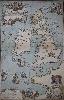
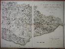
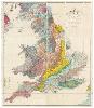
Imprint: Edinburgh, 1749
625 x 400 mm., with a couple of areas of loss in the lower neat line and corners repaired, some loss to text lower left, small tear into the top of the map repaired, otherwise in very good condition. With old manuscript notation in pencil to verso 'excessively rare'.
EXCEEDINGLY RARE MAP RELATED TO BONNIE PRINCE CHARLIE KNOWN IN ONLY FOUR EXAMPLES. James Grante was a Scotsman and French Officer who travelled with Prince Charles through much of 1745 Rebellion. 'Of the several maps designed to show the travels and battles of Prince Charles Edward in 1745-46 this single-sheet derivation of James Grante's large master map is probably the most attractive. It appeared folded in a small anonymous book with a similar title to that on the map, with supplementary text which for the most part merely repeats the legends printed on the body of the map itself. The attraction of the map lies in the numerous allegorical figures which grace the stages of the Prince's escape and adorn the corners. The routes of the English pursuers are shown and many vivid illustrations of ships of the period indicate the various naval engagements (Shirley).' Mathieson wrote in the 'Scottish Geographical Magazine' in 1930 that there was only one recorded example of the map. There were only four recorded examples known; BL; Royal Library, Windsor; National Archives; Private Collection. Two further examples have since been identified; one at the National Library of Scotland and another recently acquired by a private collection. This example makes a total of seven known. Provenance: acquired from the Parker Gallery, London, c.1955. Bartholomew & Son 'Bonnie Prince Charlie Maps, Edinburgh; Mathieson 'A French Map of Prince Charles' Campaigns', Moir 'Early Maps of Scotland' p. 143; Scottish Geographical Magazine May 1931; Shirley British Isles Grante 3.
Stock number:7144.
|
|
Imprint: London, Sherwood, Jones, and Co. Paternoster Row, 1824
Binding: Hardback Octavo (145 x 120 mm.), contemporary half red calf, with paper boards, spine with blind ruled bands, gilt year and title. Engraved title, (2), v, (3), 86, (70), (28) pp., with 50 maps, comprising folding general map of England and Wales opposite the title, Index general map opposite 'Reference to the Maps' numbered 0, maps numbered to 47 including 40 counties, 3 of Yorkshire Ridings, Lake District, South Scotland, North and South Wales and the Isle of Thanet unnumbered but '48' in the list of contents. Folding general browned and with some old repair, large folding map of Derbyshire often missing here with a tear, all maps in fine early wash colour, otherwise in good condition.
A fine road book featuring a complete set of English county maps by Charles Cooke (1750-1816). The plates are similar to those in Wallis's 'New Pocket Edition' of c.1812. He was a bookseller who succeeded his father in Paternoster Row around 1789. The maps were originally published in 'Cooke's Modern British Traveller' of 1802-10 with text written by George Alexander Cooke. They were not related. It was issued in 25 volumes. Following Charles Cooke's death in 1816 the plates were published by Sherwood, Neely and Jones in 'Topography of Great Britain or British Traveller's Directory' in 1817. The text was updated and published 'by Assignment from the Executors of the late C Cooke'. George Carrington Gray's 'Book of Roads' was available according to the initial title page 'Price Seven Shillings Bound; or, With a Series of Maps, Forming a Complete County Atlas, Twelve Shillings Bound'. This also includes a nice little vignette scene of a rider paying at a toll-gate. With extensive details of the roads followed by the county atlas and an Index. The maps are unaltered from earlier issues beyond the addition of a plate number. About the compiler Gray, little is known. The Preface states that he is aware of the 'two books of established reputation on the subject, those of Paterson and Carey'. He goes on to state that 'a third book ... may also possess advantages, exclusively its own'. There follows an extensive description of these beginning 'we are enabled to concentrate and bring under the immediate notice of the traveller, at one reference from the General Index, the various lines of route leading to any required point of distance ...' Provenance: private English collection. Carroll (1996) no. 63; Chubb (1927) 392; Fordham (1924) p. 58; Tooley's Dictionary (1999-2004).
Stock number:9235.
|
|
|
Imprint: London, Sherwood, Jones, and Co. Paternoster Row, 1824
Binding: Hardback Octavo (145 x 120 mm.), contemporary half calf, with marbled paper boards, rebacked with matching spine, gilt ruled compartments, each with central gilt star feature, gilt title. With typographic title with a woodcut vignette, further typographic title as above, pp. (2), (viii), 86, (70), (28) with 49 further maps (3 folding) in early outline colour, Index general map opposite 'Reference to the Maps' numbered '0', maps numbered to 47 including 40 counties, 3 of Yorkshire Ridings, Lake District, South Scotland, North and South Wales and the Isle of Thanet unnumbered but '48' in the list of contents, otherwise in good condition.
A fine road book featuring a complete set of English county maps by Charles Cooke (1750-1816). The plates are like those in Wallis's 'New Pocket Edition' of c.1812. He was a bookseller who succeeded his father in Paternoster Row around 1789. The maps were originally published in 'Cooke's Modern British Traveller' of 1802-10 with text written by George Alexander Cooke. They were not related. It was issued in 25 volumes. Following Charles Cooke's death, the plates were published by Sherwood, Neely and Jones in 'Topography of Great Britain or British Traveller's Directory' in 1817. The text was updated and published 'by Assignment from the Executors of the late C. Cooke'. George Carrington Gray's 'Book of Roads' was available according to the initial title page 'Price Seven Shillings Bound; or, With a Series of Maps, Forming a Complete County Atlas, Twelve Shillings Bound'. This also includes a nice little vignette scene of a rider paying at a toll-gate. With extensive details of the roads followed by the county atlas and an Index. The maps are unaltered from earlier issues beyond the addition of a plate number. About the compiler Gray, little is known. The Preface states that he is aware of the 'two books of established reputation on the subject, those of Paterson and Carey'. He goes on to state that 'a third book ... may also possess advantages, exclusively its own'. There follows an extensive description of these beginning 'we are enabled to concentrate and bring under the immediate notice of the traveller, at one reference from the General Index, the various lines of route leading to any required point of distance ...' It appears an early owner might have been a doctor. The first free endpaper includes a manuscript list of items to take on his travels. Provenance: booksellers label inside front cover of E. Collings, Bath; inscription inside upper cover of A Landon?; private English collection. Carroll (1996) no. 63; Chubb (1927) 392; Fordham (1924) p. 58; Tooley's Dictionary (1999-2004).
Stock number:10238.
|
|
Imprint: London, William Faden, 4 June 1795
790 x 1915 mm., the whole, in four separate sheets, early outline colour, trimmed to the top and bottom borders, sheet 2 with tear upper left just into the image, repaired, a couple of areas of margin weakness otherwise a good example.
This is one of the most important maps of Sussex and one of the rarest, here offered in the preferred sheet format rather than folding. It is the first map of the county to be based on a trigonometrical survey. Although the title credits William Gardner (1739-1800) and Thomas Yeakell (fl.1758-1787) as the mapmakers the influence of the Board of Ordnance was significant. The Master of the Board was the Duke of Richmond under whom the Ordnance Survey became fully operational in 1790. Both Yeakell and Gardner worked for it. Under the patronage of the Duke a map of Sussex by Yeakell and Gardner was announced in 1791. Unsurprisingly the map was a forerunner of the early Ordnance Survey maps. Published by William Faden this map won a Society of Arts Gold Medal in 1796. The 'Proposals' claim that 'every farm-house, barn and garden will have its place. Every enclosure with the nature of its fence whether bank, ditch, pale or wall, will be delineated.' This detail was the work of Thomas Gream (fl.1782-1809). This is an example of the third state of four dated 1795 according to Kingsley, the first being a proof example. On paper watermarked 'Pard 1794'. Baynton-Williams, Roger (1995) '200th birthday of Sussex map', in 'The Map Collector' no. 71 pp. 39-41; Kingsley 57.iii; Rodger 459.
Stock number:7314.
|
|
|
Imprint: London, Published by W: Faden, Geographer to His Majesty and to His Royal Highness the Prince of Wales, Charing Cross, 12 August 1799
365 x 790 mm., dissected and laid on contemporary linen, full early wash colour, Faden's paper label affixed to verso, with publisher's original marbled paper slipcase, with Faden's label on front, a good example.
William Gardner (1739-1800) and Thomas Yeakell (fl.1758-1787) four-sheet map of Sussex published in 1795 is one of the most important maps of the county and one of the rarest. It is the first map of the county to be based on a trigonometrical survey. The Master of the Board was the Duke of Richmond under whom the Ordnance Survey became fully operational in 1790. Both Yeakell and Gardner worked for it. Unsurprisingly the map was a forerunner of the early Ordnance Survey maps. Published by William Faden this map won a Society of Arts Gold Medal in 1796. In 1799 Faden published this single sheet reduction which is here found in folding format. A note lower right records The Distances on the Great Roads are measured from Westminster Bridge, Surrey Side. Those on the Cross Roads are measured from Town to Town'. It was engraved by John Palmer (fl.1799-1818), he went on to work on the Ordnance Survey maps from about 1808-18. Baynton-Williams, Roger (1995) '200th birthday of Sussex map', in 'The Map Collector' no. 71 pp. 39-41; Kingsley (1982) 58.i; Rodger (1972) 461; Worms & Baynton-Williams (2011).
Stock number:9976.
|
|
Imprint: London, 1804
135 x 90 mm., in early outline colour, bound with accompanying descriptive text, in good condition.
This charming little map is from an extremely rare atlas by William Green entitled the 'Picture of England' and printed in 1804. It was first issued by Robert Butters as 'An Atlas of England' the previous year. Of that work only two known examples survive. Butters (fl. 1785-1808) was a printer in London who took over and completed the 'Political Magazine' series of county maps by John Lodge. In the same year it was published as 'The Picture of England' by John Hatchard (1769-1849), the only known example of which was broken up. Hatchard was the founder of the bookshop which still bears his name on Piccadilly, London. This edition published the following year also by Hatchard is the first to recognise William Green (1760-1823) on the title page and alludes to him being the author. Green was born in Deansgate, Manchester, and trained as a surveyor. He produced the fine large scale map of Lancashire by William Yates in 1786. Although an 'artist, draughtsman, surveyor, etcher and engraver' it is not clear if he was responsible for these plates. The map is derived from that of John Cary issued in the 'Travellers Companion' but is notable for its curious orientation. North is to the left although the compass indicator is pointing south. Green died at Ambleside in the Lake District, his epitaph was written by William Wordsworth.Hatchard after completing his apprenticeship to a printer and bookseller went to work for the leading bookseller Thomas Payne in 1789. Leaving his employ in 1797 he opened his first shop at 173 Piccadilly and struggled. But not without considerable industry he made it work and moved again in 1801 to 190 Piccadilly. His son joined him in 1808 and in 1823 they made their final move to 187 Piccadilly where they remain to this day. Hatchard borrowed from Payne who was the first to combine a coffee house and booksellers and offered the same convivial surroundings. Carroll (1996) 58; Chubb (1927) 318; ODNB; Worms & Baynton-Williams (2011).
Stock number:9318.
|
|
|
Imprint: London, 1804
Binding: Hardback Octavo (205 x 125 mm.), two volumes uncut, contemporary half burgundy calf, green paper boards, spine with ruled compartments, gilt titles and volume number. Volume 1 with engraved frontispiece of Britannia, engraved title page, Preface, Introduction, pp. (2), iv, 5-195, with 19 county maps; volume 2 with general map, engraved title page, pp. 248 and 21 further county maps, in total 41 maps, all in early outline colour, wash colour to general map, wash to the sea on some initial coastal counties as usual, in good condition.
A VERY RARE COUNTY ATLAS. This charming atlas contains a series of maps of the English counties, many of which are orientated unusually. William Green's Picture of England printed in 1804, was first issued by Robert Butters as An Atlas of England the previous year. Of that work only two known examples survive. Butters (fl. 1785-1808) was a printer in London who took over and completed the Political Magazine series of county maps by John Lodge. In the same year this particular series was published as The Picture of England by John Hatchard (1769-1849), the only known example of which was broken up. Hatchard was the founder of the bookshop which still bears his name on Piccadilly, London. This edition published the following year also by Hatchard, is the first to recognise William Green (1760-1823) on the title page and alludes to him being the author. Green was born in Deansgate, Manchester, and trained as a surveyor. He produced the fine large scale map of Lancashire by William Yates in 1786. Although an 'artist, draughtsman, surveyor, etcher and engraver', it is not clear if he was responsible for these plates. The maps are derived from those of John Cary issued in the Travellers Companion but are notable for their curious orientation. The general map of England and Wales usually bound at the beginning of the second volume, has the south at the top. The order of the maps is largely alphabetical except for Cheshire following Cumberland and Leicestershire at the end of the first volume before that of Lancashire. These have been dictated by the order of the text. This is a second issue bearing the second state of the Norfolk map. Green died at Ambleside in the Lake District. His epitaph was written by William Wordsworth.After completing his apprenticeship to a printer and bookseller, Hatchard went to work for the leading bookseller Thomas Payne in 1789. Leaving his employ in 1797 he opened his first shop at 173 Piccadilly and struggled. But not without considerable industry he made it work and moved again in 1801 to 190 Piccadilly. His son joined him in 1808 and in 1823 they made their final move to 187 Piccadilly where they remain to this day. Hatchard borrowed from Payne, who was the first to combine a coffee house and booksellers and offered the same convivial surroundings. Provenance: manuscript ownership mark of 'Eliza. W. Coke' on engraved frontispiece and in vol. 2; bookplate of Roy Johnstone (1923-98) collection in both volumes; private English collection. Carroll (1996) 58; Chubb (1927) 318; Frostick (2011) 66.1; ODNB; Worms & Baynton-Williams (2011).
Stock number:10219.
|
|
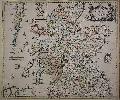
Imprint: London, By Robert Greene at the Rose and Crown in Budg-row, 1679-[c.85]
470 x 550 mm., in early outline colour, printed on thick paper with fold along the left side to facilitate inclusion in the Berry atlas, in good condition.
'SCOTLAND'S EARLIEST ROAD MAP' (Fleet, Wilkes and Withers). The first state bore the imprint of both Robert Greene and William Berry. The map was first advertised in the Term Catalogue in 1679. This is the second state bearing that of Greene only. According to Moir it was issued sometime before 1689 when it was advertised by his eldest sister Elizabeth. This is the EARLIEST MAP OF SCOTLAND AS A WHOLE TO SHOW THE ROADS. It was engraved by Francis Lamb. Greene was a map seller, as opposed to a maker such as Berry, and could also supply a printing press to the relationship. The cartouche describes Greene's shop as a place "Where you may have all sorts of Mapps." This second state dates from before his death which was recorded 12 February 1688. As he was a widower the business was left to his son Nathan. Being underage the business was left in the care of his eldest sister Elizabeth. Provenance: from a William Berry atlas; private English collection since c.1975. Fleet, Wilkes and Withers p. 204; Moir, D.G. Vol. 1, p.173; Term Catalogues Vol. I p. 359 & Vol. II p. 281; Tyacke p. 117.
Stock number:8335.
|
|
Imprint: London, 1883-87[88]
Binding: Hardback Octavo, three volumes (255 x 180 mm.). Full contemporary publishers green cloth, gilt parrot ornamentation to boards, light wear, otherwise in good condition. With 81 hand coloured lithographs.
This fabulous work on parrots was first published in parts, thirty in all, which are very rare. The bound publication was intended to include a fourth volume but it was never published. The last three parts with 9 plates are therefore almost impossible to find. Fine Bird Books 79; Nissen 393; Wood, p. 368; Zimmer p. 274.
Stock number:7874.
|
|
Imprint: London, Geological Society, July 1865-[c.1877]
Binding: Hardback 1960 x 1610 mm. the whole, to the scale of 6 miles to the inch, with early wash colour, four sheets on paper watermarked J. Whatman dated 1877, sectionalised and laid on linen, with silk edging, some minor spots, marbled endpapers, otherwise in good condition. [With] Octavo, later half green morocco, marbled paper boards, pp. xi, 29, all housed in original brown cloth slipcase with manuscript label.
THE THIRD EDITION OF GREENOUGH'S GEOLOGICAL MAP OF ENGLAND AND WALES AND THE FIRST TO ACKNOWLEDGE WILLIAM SMITH, WITH THE RARELY FOUND 'MEMOIR'.One of the most significant geological maps of England and Wales ever published. George Greenough (1778-1855) was accused of plagiarism at the time of this maps first publication in 1820, just five years after the landmark work of William Smith published in 1815. Greenough was one of the founding members of the Geological Society of London and was its first president to 1811. 'In 1808 he first sketched the boundary-lines of the various strata in England and Wales, and in 1810 he travelled over a great part of the country for the purpose of mapping it. At the request of the Geological Society he then, with the help of Conybeare, Buckland, and Henry Warburton, coloured a large scale-map drawn by Webster, and in 1820 published it in six sheets' (DNB).It began a bitter feud, Greenough published a Memoir of a Geological Map of England in which he defended his work. He claimed Mr Smiths map was not seen by me till after its publication, and the use I have since made of it has been very limited. The two maps agree in many respects, not because the one has been copied from the other, but because both are correct
(Memoir). Much has been written on to what extent Smiths Map influenced Greenough and exactly when the latter actually saw a version of the work, but certainly both the Society and Greenough were amongst the list of subscribers to the publication and each received a copy of the first imprint. Tellingly, the sheets of Greenoughs copy are marked with notes recording that he did indeed consult it, with comments such as 'This sheet can be of no further use to the Geol Map, Nov 1818' (Geological Society website).Smith, whose social status did not amount to much, suffered and eventually found himself in debtors prison. Recognition of Smiths contribution to geology took years, in 1831 he was finally awarded the Woolaston medal by the Geological Society. Greenoughs map is now recognised as a separate work of scholarship which drew on other surveyors which he then collated. There are a number of key visual differences between the two mens maps, most notably the scale Smiths at 5 miles to the inch and Greenoughs at 6 miles to the inch. Another distinction is that whilst Smiths base map has virtually all the topography removed, hills and mountains are included in Greenoughs version. Smith's Map used his distinctive fading watercolour technique, whilst Greenough's employed flat colour washes and patterning to depict his stratigraphy (The Geological Society). This third edition was published a decade after Greenoughs death at the behest of a committee which included John Phillips, Professor of Geology at Oxford, and a nephew of William Smiths. This edition is the first to acknowledge its connection to William Smith. An extremely rare example accompanied as it is by Greenoughs Memoir, 1840. Bassett p. 18; Challinor 91; Henry (2014) n. 39; Ward & Carozzi 952.
Stock number:9600.
|
|
|
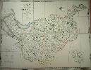
Imprint: London, Greenwood & Co., Burleigh Street, Strand, 1834
Binding: Hardback Large folio (665 x 435 mm.), full contemporary calf, ornate gilt panelled, rebacked with gilt red calf title label, marbled endpapers. With engraved title-page containing an early wash coloured map of England and Wales, 46 double-page early wash coloured engraved maps by J. and J. Neale, J. and C. Walker and others, Berkshire, Leicester, Stafford, Sussex, Warwick and Wiltshire with split centrefolds, one or two lesser ones, Lancashire and Lincolnshire just shaved which is often the case due to their size, some light offsetting and mild creases as often the case, otherwise a good example.
Following the extensive work carried out by Christopher and John Greenwood on the series of large scale county surveys, a reduced sized atlas was planned. It was advertised in 1828 to appear in four parts at three guineas per part and began as early as 1829, the date recorded on 11 of the plates. There were to be 46 plates, all at the scale of one-third of an inch to a mile. They ran into financial difficulties towards the end and had to take in partners to finish in 1834. 'For detail, general accuracy and balance allied to high quality engraving and colouring these sheets are probably the finest ever single sheet maps of the counties (Carroll). The maps are reductions of Greenwood's large scale maps of the counties as stated with the exception of those of Bucks, Cambridge, Hereford, Hertford, Norfolk and Oxford which they did not survey. Studies of individual counties show many were improved with new detail on a regular basis. Provenance: with private English collection. Carroll (1996) 102; Chubb (1927) 458b; Tooley (1999-2004); Worms & Baynton-Williams (2011).
Stock number:9918.
|
|
|
Imprint: London, 1834
Binding: Hardback Oblong large folio (665 x 810 mm.), contemporary half calf, edge bound, cloth boards, gilt ruled, with central calf gilt panelled title label affixed to upper board, spine with double raised bands, gilt ruled, marbled endpapers, light wear. With engraved title-page containing an early wash coloured map of England and Wales, 46 double-page early wash coloured engraved maps by J. and J. Neale, J. and C. Walker and others, Lancashire and Lincolnshire just shaved which is often the case due to their size, Rutland with tear in the upper margin, some light offsetting, much better example than most, otherwise a good example.
A CLEAN SIDE BOUND ISSUE WITHOUT FOLDS. Christopher Greenwood (1786-1855) and his brother John Greenwood (1791-1867) were both surveyors. Christopher Greenwood was from Yorkshire, he settled in Wakefield by about 1815 before moving to London in 1818. His first large-scale survey was of Yorkshire published in 1817. His brother John joined forces in 1821. Along with the distribution capabilities of George Pringle and Son, they made an immediate impact with their series of large scale surveys of many English counties.Following the extensive work carried out by on these, a reduced sized atlas was planned. It was advertised in 1828 to appear in four parts at three guineas per part and began as early as 1829, the date recorded on 11 of the plates. There were to be 46 plates, all at the scale of one-third of an inch to a mile. They ran into financial difficulties towards the end and had to take in partners to finish in 1834. Indeed, Christopher was imprisoned for debt in the same year.'For detail, general accuracy and balance allied to high quality engraving and colouring these sheets are probably the finest ever single sheet maps of the countiesâ (Carroll). The maps are reductions of Greenwood's large scale maps of the counties as stated except for those of Bucks, Cambridge, Hereford, Hertford, Norfolk and Oxford which they did not survey. Studies of individual counties show many were improved with new detail on a regular basis. Provenance: with private English collection. Carroll (1996) 102; Chubb (1927) 458b; Tooley (1999-2004); Worms & Baynton-Williams (2011).
Stock number:10294.
|
|
Imprint: London, 15 June 1819
Binding: Hardback 1235 x 1570 mm., large engraved folding map on two sheets, hand-coloured in outline, dissected into 32 sections, laid on linen with marbled endpapers. With original mapsellers label pasted below the title of James Wyld (successor to Mr. Faden). Folding into contemporary quarter green morocco slipcase, marbled boards, rubbed, with gilt title to the spine.
This is only the third large scale map by Christopher Greenwood preceded only by those of Yorkshire and Lancashire. It was co-published with W. Fowler of Wakefield in 1819. His brother John was at this time yet to join him in the enterprise. Engraved in wonderful large scale it differentiates between woods and plantations, heaths and commons, different types of waterway and roads. Both watermills and windmills are identified indicating their significance to the local economy. A measure of the detail that went into the survey is that the error of 3o longitude shown as passing to the east of Chester in the survey of Burdett is corrected here to being to the west of Birkenhead. Christopher Greenwood (1786-1855) was a surveyor from Wakefield, Yorkshire and moved to London in 1818. His brother John was also a surveyor and in 1821 they joined forces and with the distribution capabilities of George Pringle and Son, made an immediate impact with their series of large scale surveys of many English counties. The early 1800s was a time of rapid change in the landscape with the burgeoning industrial revolution. Their surveys utilised the latest system of triangulation adopted by Colonel Mudge and his surveyors for the Ordnance Survey. Indeed they were in open competition with them. The Greenwood maps were coloured as opposed to the more functional black and white Ordnance Surveys of the period. Tooley Ch 18 in The Map Collector 17 pp. 22-6; Rodger 47.
Stock number:4992.
|
|
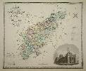
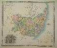
Imprint: London, Greenwood & Co, 1834
570 x 790 mm., early wash colour, in good condition.
Following the extensive work carried out by the Greenwood's on the series of large scale county surveys a reduced sized atlas was planned. It began as early as 1829, the date recorded on 11 of the plates. It was advertised in 1828 to appear in four parts at three guineas per part. There were to be 46 plates all at one-third of an inch to a mile. Running into financial difficulties towards the end they had to take in partners to finally finish in 1834. 'For detail, general accuracy and balance allied to high quality engraving and colouring these sheets are probably the finest ever single sheet maps of the counties' (Carroll). This map of Northampton contains a fine vignette view of Peterborough Cathedral. Tooley's 'Dictionary of Mapmakers', Chubb 458B.
Stock number:5485.
|
|
Imprint: London, Greenwood & Co, 1834
570 x 770 mm., early wash colour, with centrefold split repaired, otherwise in good condition.
Following the extensive work carried out by the Greenwood's on the series of large scale county surveys a reduced sized atlas was planned. It began as early as 1829, the date recorded on 11 of the plates. It was advertised in 1828 to appear in four parts at three guineas per part. There were to be 46 plates all at one-third of an inch to a mile. Running into financial difficulties towards the end they had to take in partners to finally finish in 1834. 'For detail, general accuracy and balance allied to high quality engraving and colouring these sheets are probably the finest ever single sheet maps of the counties' (Carroll). This map of Staffordshire contains a fine vignette view of Lichfield Cathedral. Tooley's 'Dictionary of Mapmakers', Chubb 458B; King 82.
Stock number:5487.
|
|
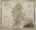
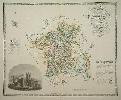
Imprint: London, Greenwood & Co, 1834
590 x 790 mm., fine early wash colour, in good condition.
Following the extensive work carried out by the Greenwood's on the series of large scale county surveys a reduced sized atlas was planned. It began as early as 1829, the date recorded on 11 of the plates. It was advertised in 1828 to appear in four parts at three guineas per part. There were to be 46 plates all at one-third of an inch to a mile. Running into financial difficulties towards the end they had to take in partners to finally finish in 1834. 'For detail, general accuracy and balance allied to high quality engraving and colouring these sheets are probably the finest ever single sheet maps of the counties' (Carroll). This map of Suffolk contains a fine vignette view of the Abbey Gare at Bury St. Edmonds. Tooley's 'Dictionary of Mapmakers', Chubb 458B.
Stock number:5488.
|
|
Imprint: London, Greenwood & Co, 1834
570 x 780 mm., early wash colour, with centrefold split repaired, otherwise in good condition.
Following the extensive work carried out by the Greenwood's on the series of large scale county surveys a reduced sized atlas was planned. It began as early as 1829, the date recorded on 11 of the plates. It was advertised in 1828 to appear in four parts at three guineas per part. There were to be 46 plates all at one-third of an inch to a mile. Running into financial difficulties towards the end they had to take in partners to finally finish in 1834. 'For detail, general accuracy and balance allied to high quality engraving and colouring these sheets are probably the finest ever single sheet maps of the counties' (Carroll). This map of Worcestershire contains a fine vignette view of Worcester Cathedral. Tooley's 'Dictionary of Mapmakers', Chubb 458B.
Stock number:5489.
|
|