|
|
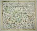
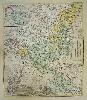
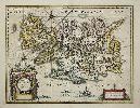
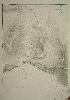
Imprint: Nuremberg, 1728
500 x 580 mm., in early wash colour and good condition.
The famous German firm of cartographic publishers was founded by Johann Baptist Homann in 1702 in Nuremberg. In 1707 he published the "Neuer Atlas" whose success continued for many years. In recognition of his success Homann was elected to the Berlin Academy of Sciences. In 1715 Homann was appointed Geographer to the Emperor. Homann died in 1724 and was succeeded by his son Johann Christoph (1703-30) who died shortly after. This large scale detailed map covers the region of Hanau around the city of Frankfurt which is shown prominently lower left. The map extends northwards to Giessen and extends eastwards to beyond Gelnhausen. Upper centre is a panorama of the city of Hanau. The cartography is the work of Friedrich Zollmann (1690-1762) a Dutch cartographer who worked for Homann.
Stock number:7013.
|
|
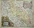
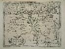
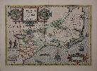
Imprint: Nuremberg, c.1720
480 x 560 mm., early wash colour, with a couple of minor foxmarks, otherwise in good condition.
A fine detailed map of the region of Silesia which sits on the River Oder which flows south east to north west across the map. It bears a large decorative cartouche and inset plan of Breslaw (Breslau) held aloft by Cherubs, itself in the centre of the map. This first state example lacking the privilege is from an early edition of Johann Baptiste Homann's 'Atlas Novus Terrarum'. The city of Dresden is just featured on the left of the map.
Stock number:6382.
|
|
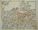
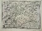
Imprint: Nuremberg, c.1720
420 x 540 mm., early wash colour with light colour offset in one area, otherwise in good condition.
A large scale map of the region to the east of Hamburg, Germany. The map extends to Lubeck and upriver to Hitzger. With an inset of Hadeln. The famous German firm of cartographic publishers was founded by the engraver Johann Baptist Homann in 1702 in Nuremberg. In 1707 he published the "Neuer Atlas" whose success continued for many years. In recognition of his success Homann was elected to the Berlin Academy of Sciences. In 1715 Homann was appointed Geographer to the Emperor. Homann died in 1724 and the business was continued by his son Christoph (1703-30) and his heirs. Shirley, R.W. (BL Atlases) T.HOM-8a, Vol. V, #1.
Stock number:5526.
|
|
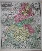
Imprint: Nuremberg, c.1720
580 x 490 mm., full early wash colour in good condition.
A wonderful detailed map of the Champagne district in France. The map extends are far north as Compiegne and Neuchatel and south to Auxerre. An inset upper left illustrates the two towns of Troyes and Reims. The map is by Johann Baptist Homann (1664-1724) who began engraving and publishing separate maps around 1702, and producing standardised and composite atlases entitled 'Neuer Atlas' in 1707. Its success continued for many years and in recognition of his success Homann was elected to the Berlin Academy of Sciences. In 1715 Homann was appointed Geographer to the Emperor. This map includes the privelege granted to Homann Shirley believed in 1715. Heinz, Markus (1997). A Programme for Map Publishing: The Homann Firm in the Eighteenth Century, Imago Mundi, no. 49, pp. 104-15; Shirley (BL Atlases) T.HOM-1c, no.16.
Stock number:8631.
|
|
Imprint: Nuremberg, 1729
560 x 470 mm., early wash colour, in good condition.
A large scale map of the region to the east of Hamburg, Germany. The map extends to Lubeck and upriver to Hitzger. With an inset of Hadeln. The famous German firm of cartographic publishers was founded by the engraver Johann Baptist Homann in 1702 in Nuremberg. In 1707 he published the "Neuer Atlas" whose success continued for many years. In recognition of his success Homann was elected to the Berlin Academy of Sciences. In 1715 Homann was appointed Geographer to the Emperor. Homann died in 1724 and the business was continued by his son Christoph (1703-30) and his heirs.
Stock number:5528.
|
|
Imprint: Amsterdam, 1607-[21]
150 x 190 mm., light even toning otherwise in good condition.
This attractive map of the Nile delta in Egypt is from Jodocus Hondius' miniature version of Gerard Mercator's great atlas entitled the 'Atlas Minor'. With Latin text to the verso. Van der Krogt, P. (Atlantes) 8650:351.
Stock number:4865.
|
|
Imprint: Amsterdam, 1607-[09]
130 x 190 mm., in fine condition.
This attractive map is from Jodocus Hondius' miniature version of Gerard Mercator's great atlas entitled the 'Atlas Minor' first published in 1607. This example is from the edition of 1609 with German text to the verso. Van der Krogt, P. (Atlantes).
Stock number:4769.
|
|
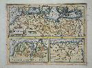
Imprint: Amsterdam, 1607
140 x 180 mm., in good modern wash colour, good condition.
The top half of the map features the coast of Barbary, or the whole of North Africa. Below are two insets of Carthage in modern day Tunisia and the Nile Delta in Egypt. This attractive map is from Jodocus Hondius' miniature version of Gerard Mercator's great atlas entitled the 'Atlas Minor'. With German text to the verso. Van der Krogt, P. (Atlantes) 8610.351.
Stock number:4549.
|
|
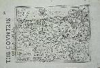
Imprint: London, 1637
150 x 200 mm., printed on a leaf with English text.
The letterpress title on the page reads 'The Countrie of Flanders'. It comes from the Wye Saltonstall edition of the Jodocus Hondius plates first published in the 'Atlas Minor' of 1607 in Amsterdam. Entitled the 'Historia Mundi' it ran to three editions in 1635, 1637 and 1639. Published in London by Michael Sparke & Samuel Cartwright. Shirley BL Atlases T.Hon-1e.
Stock number:4659.
|
|
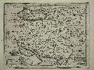
Imprint: Amsterdam, 1607
140 x 190 mm., in very good condition.
This attractive map of Persia or modern day Iran is from Jodocus Hondius' miniature version of Gerard Mercator's great atlas entitled the 'Atlas Minor'. With German text to the verso. Van der Krogt, P. (Atlantes) 8200:351.
Stock number:4956.
|
|
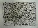
Imprint: Amsterdam, 1607
14 x 18 cm. Uncoloured map, which has been cleaned, a fine dark impression. Faint remains of a library stamp lower right hand margin.
From Hondius' miniature version of Mercator's great atlas entitled the 'Atlas Minor', with Latin text. Van der Krogt, P. (Atlantes) 5802:351.
Stock number:3255.
|
|
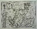
Imprint: Amsterdam, 1607
14 x 18 cm. Uncoloured map, which has been cleaned, a fine dark impression. Faint remains of a library stamp lower right hand margin.
From Hondius' miniature version of Mercator's great atlas entitled the 'Atlas Minor', with Latin text. Van der Krogt, P. (Atlantes) 5801:351.
Stock number:3256.
|
|
Imprint: Amsterdam, 1636
380 x 490 mm., in recent outline colour, light show through of text, otherwise in good condition.
A superb ornate map of Iceland displaying a volcano in all its explosive glory. The map is derived from a Dutch navigator called Joris Carolus about 1620. The map is dominated by prominent mountains and volcanoes. It was first issued in the 'Appendix' of 1630. This example is with Dutch text from the edition of 1634. Dreyer-Eimbcke, Oswald. (2000). Cartographic History of Iceland, in IMCoS Journal no. 81 pp.13-33; Van der Krogt, P. (Atlantes) 1250:1B.1.
Stock number:9664.
|
|
Imprint: Amsterdam, 1606-[19]
Edition: First Edition 350 x 490 mm., early wash colour with French text, in good condition.
A lovely example of this classic decorative map. The only regional map of North America to be included in the first edition of Jodocus Hondius first edition of Gerard Mercator's atlas. 'It is a composite largely of John White's Virginia and Jacques le Moyne's Florida as interpreted by Theodore de Bry in 1590 and 1591 respectively. Chesepioock Sinus representing Chesapeake Bay is still shown in its White delineation. At the end of this year, 1606, a party of Englishmen left England to begin arguably the most important colonisation of North America in this very bay, at Jamestown. Within just a few years the entire region would be completely revised cartographically. The area south towards C.S.Romano Hispanis is entirely drawn from White. It is, however, given too much latitude, extending as far as 322o, some 2o too far. S.Augustine, however, is shown at the correct latitude. The combined effect is a compacted coastline for the present-day States of Georgia and South Carolina.The area of French Floridæ originally comes from de Bry's map Floridae Americae Provinciae of 1591. Here a new interpretation of the cartography had made this map notable; however, the author has noted that it actually first appeared on the wall map of America by Cornelis Claesz, c.1602. The new rendition of le Moyne's geography is caused by the great lake which is moved from central Florida north so that the R.de May (St. John's River) now flows in a south-easterly direction. It was probably encouraged by the depiction on a number of maps of a similarly flowing large R.Secco like that on the FLORIDA et APALCHE, by Cornelis Wytfliet of 1597. Its influence was considerable. Taken up by Hondius, this error was popularised by the major success of his atlas and lasted for some seventy years. According to Cumming some place names appear from other sources, namely that of Jean Ribaut. In the Apalatcy Mountians references are made to the presence of both gold and silver. The map is embellished with various game including a wild turkey. Examples of Indian villages in Florida and Virginia appear in cartouches either side of the title. The map's scale and decorativeness make it very sought after' (Burden). Burden 151; Cumming no. 26.
Stock number:9123.
|
|
|
Imprint: London, Virtue & Co., City Road and Ivy Lane, 1873
Binding: Hardback Folio (355 x 265 mm.), modern red cloth binding, spine with raised bands, gilt ruled, each compartment with central gilt decoration, gilt title, later endpapers, gilt edged. With typographic title page, pp. (4). 186 and 68 chromolithographic county maps of England, Scotland and Wales, otherwise in good condition.
This series of maps was first issued as The National Gazetteer in parts from 1863-68. It was then made available as a twelve volume work in 1868. Their next appearance was here in atlas form, with some accompanying descriptive text. William Hughes (1818-76) worked as a cataloguer at the British Museum on geography books from 1841-43. From 1863-75 he was a Professor of Geography at Kingâs College, London, and wrote several theoretical works on the subject. The founder of the publishing firm was George Virtue (c.1793-1868), whose company records show Hughes as a supplier of plates. The maps here are attractive and of individual counties with the exception of Scotland where they are grouped together in regions. Those of Ireland are individual. They are all derived from the Old Series One Inch Ordnance Survey. The map of the North Atlantic now acts as a frontispiece and the county maps begin with Northumberland working their way south to Cornwall. Beresiner (1983) p. 117; Carroll (1996) 126; refer Chubb (1927) 562; Tooley's Dictionary (1999-2004).
Stock number:10327.
|
|
|
Imprint: London, James S. Virtue City Road and Ivy Lane, 1868
Edition: First Edition Binding: Hardback Quarto, 12 volumes (275 x 185 mm. each), full contemporary blue cloth binding, elaborate blind decorated boards, gilt royal arms to upper board, spine with ornate gilt decoration and titles, light wear. With woodcut title page 68 chromolithographic county maps of England, Scotland and Wales.
The National Gazetteer was first issued in parts from 1863-68. The prospectus stated that the work would be completed in about 35 parts of 80 pages each, or in 12 Divisions at 7s. 6d. each. This is the first edition of the work in its 12 Divisions. William Nightingale Hughes (1817-76) worked as a cataloguer at the British Museum on geography books from 1841-43. From 1863-75 he was a Professor of Geography at Kingâs College, London. The founder of the publishing firm was George Virtue (c.1793-1868) whose company records show Hughes as a supplier of plates. The maps here are attractive and of individual counties except for Scotland where they are grouped together in regions. Beresiner (1983) p. 117; Carroll (1996) 126; Chubb (1927) 562.
Stock number:10316.
|
|
Imprint: London, 1862-[93]
750 x 470 mm., in good condition.
A fine detailed chart of the Bay of Acre in Syria. Either end of the bay can be seen in detail the towns of Acre and Haifa.
Stock number:5510.
|
|
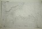
Imprint: London, 1841-[72]
620 x 960 mm., uncoloured, minor foxmark centre right.
Large detailed chart on the approaches to Belfast harbour. Surveyed by Captain F. W. Beechey with corrections to May 1872. Engraved by J. & C. Walker.
Stock number:2868.
|
|
Imprint: London, 18 December 1854
680 x 510 mm., with pasted on extension lower right, in good condition.
Balaclava in the Ukraine is immortalised in history by the Battle named after it during the Crimean War. It is famous for the disastrous 'Charge of the Light Brigade' in which 250 men and 400 horses were lost. It formed part of the campaign on behalf of the Anglo-French-Turkish forces to capture Sevastapol, then Russia's main naval base on the Black Sea. A final military charge on 25 October 1854 came from the misinterpreted orders of Lord Raglan. The Brigade were sent up a valley strongly defended by the Russians on three sides. The event is remembered most famously in the poem 'The Charge of the Light Brigade' by Alfred, Lord Tennyson. The fabulously detailed chart depicts the area just 8 weeks after the battle and marks the town in some detail and the British Burial Ground.
Stock number:5373.
|
|
|
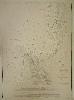
Imprint: London, 1877
220 x 290 mm., in fine condition.
A fine detailed chart of the island of St. Vincent showing many depth soundings in and around the Porto Grande. Topographical details is shown also.
Stock number:5031.
|
|