|
|
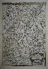
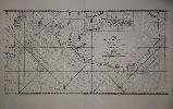
Imprint: London, 1881[92]
63.5 x 47.5 cm. Uncoloured, detailed chart. With a diagonal crease running through lower right hand corner.
A magnificent sea chart of the harbour of Cartagena in Murcia, southern Spain
Stock number:3310.
|
|

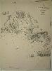
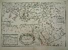
Imprint: London, 1877[92]
65.5 x 48.5 cm. Uncoloured chart, a minor nicks to margin, repaired
An extremely large scaled sea chart of the town and harbour of Valencia, even for an Admiralty Chart. Individual streets are not only clear, but named
Stock number:3311.
ISBN:r
|
|
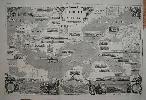
Imprint: London, May 31 1856
490 x 760 mm., folded as issued in very good condition.
This map of the Baltic Sea cut by W. Thomas was issued as a Supplement to the Illustrated London News on 31 May 1856. It contains numerous vignette views of ports and harbours in the Baltic Sea. It features many of the sites of military conflict during the recently ended Crimean War especially St. Petersburg and Cronstadt. The verso bears a large double view of 'The Fleet At The Great Naval Review, At Spithead, April 23, 1856. - Drawn by E. Duncan'.
Stock number:8182.
|
|

Imprint: London, 1872
49 x 118 cms., backed on linen. Some slight wear to lower centrefold, restored. Otherwise in good condition.
A magnificent panoramic birds-eye view of Plymouth, Devon.
Stock number:3772.
|
|
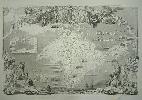
Imprint: London, 1856
505 x 770 mm., with folds as issued. Top left margin reinstated after removal to allow for binding by the publisher. One small crease lower right mostly in the margin, otherwise a good clean example.
A rare folding supplemental plate to the Illustrated London News issued at the end of the Crimean War which raged from October 1853 to February 1856. With several inset views of towns and two inset maps of the Black Sea and the Town and Harbour of Sebastopol.
Stock number:5025.
|
|
Imprint: Amsterdam, Pierre Mortier, 1692
800 x 560 mm., printed from two plates, joined, early outline colour, small tear to lower margin, repaired, light offset visible in the title, very light centrefold crease, otherwise in good condition.
An attractive large scaled map of Alsace extending from Basle in the south to Philipsbourg in the north. The map centres on Strasbourg which is prominently displayed. With an ornate title cartouche. This map appears in the Dutch edition published by Pierre Mortier and is derived from the Parisian original. Pastoureau, M. Jaillot I-D,14.
Stock number:7116.
|
|
Imprint: Paris, 1693
Edition: First Edition 460 x 900 mm., in fine condition, with very large margins, thick paper and superb watermark, a nice dark impression.
Alexis Hubert Jaillot (1628-88) was the leading French cartographer of the late seventeenth century. The Neptune Francois was first published in Paris in 1693. Issued with official approval it was a magnificent work with beautifully engraved large clear plates. It was however immediately copied by Pierre Mortier who issued an edition in Amsterdam before the year was finished. With superior Dutch marketing the Dutch editions were a success. The Paris edition suffered accordingly and is today quite rare. This detailed chart from the FIRST EDITION and therefore in the FIRST STATE covers the waters from the Isle of Thanet in Kent to the Norfolk Broads taking in Essex, and Suffolk on the way. Pastoureau (1984) Neptune Francais A no. 8; Shirley (2004) T. M.Nep 1a.
Stock number:8775.
|
|
Imprint: Paris, 1695
Edition: First Edition 460 x 650 mm., in early outline colour. Small centre fold split and nearby margin tear, neither effecting the image, restored, otherwise in good condition.
This map was prepared by Nicolas Sanson and engraved by Robert Cordier for the first edition of Alexis Hubert Jaillot's "L'Atlas Francais", 1695. Published in Paris. Al-Qasimi pp. 90-91Pastoureau, M. Jaillot II,98.
Stock number:5087.
|
|
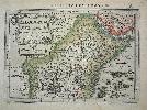
Imprint: Paris, 1704
65 x 46 cms., early outline colour. In fine condition
Jaillot (1628-88) was the leading French cartographer of the late seventeenth century. Clearly engraved by Cordier this map displays great detail of Bavaria, Germany. With fine ornate cartouches. Pastoureau, M. Jaillot, II-E, 82.
Stock number:4222.
|
|
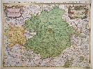
Imprint: Paris, 1678-[95]
80 x 56.5 cms., early wash colour, a couple of minor tears repaired to the outer margin
This detailed map of the Burgundy region is from Jaillot's 'Atlas Nouveau' first published in 1681. In preparation for a number of years this map was first available separately in 1675. This is a later state with the date altered to 1696. Jaillot (1628-88) was the leading French cartographer of the late seventeenth century. The map centres on Besancon and extends to Lake Geneva in the south. Pastoureau Jaillot I no. 12; Shirley 'Atlases in the BL' T.Jai 1a no. 11.
Stock number:3602.
|
|
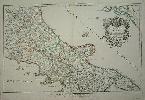
Imprint: Paris, 1703-[06]
In two sheets 475 x 745 mm. and 430 x 745 mm., in fine early outline colour.
A magnificent two sheet map of the Kingdom of Naples from Jaillot's "Atlas Francois". The whole is beautifully adorned with two decorative cartouches. Jaillot (1628-88) was the leading French cartographer of the late seventeenth century. Pastoureau Jaillot 2E nos. 188 & 9.
Stock number:4650.
|
|
Imprint: Amsterdam, 1700
47 x 61 cms. Early wash colour, a little narrow margin top right but the platemark is all present
A beautiful example of a rare map from Mortier's larger atlas
Stock number:2898.
|
|
Imprint: Paris, 1707
460 x 650 mm., in early outline colour. With small tear to lower margin repaired, not effecting image, otherwise in fine condition.
An attractive map of modern day Belgium engraved by Cordier. A very ornate title cartouche adorns the map upper left. This is the second state, the first being dated 169[]. Pastoureau Jaillot II no. 54 & IID dated 1707 as here.
Stock number:4667.
|
|
Imprint: Amsterdam, 1628
130 x 190 mm., in early outline colour. Good condition.
This map of central Africa focuses on the land of the legendary Christian King, Prester John. His fortified kingdom is depicted on top of a mountain. The Nile River flows from two large lakes. The map was engraved by Petrus Kaerius who places an ornate title cartouche upper left. It was produced to be included in Jan Jansson's edition of Mercator's 'Atlas Minor'. With Latin text on verso. Van der Krogt, P. (Atlantes) 8720:352.1.
Stock number:4633.
|
|
|
Imprint: Amsterdam, c.1652
380 x 525 mm., in modern outline colour, in good condition.
An attractive map of the coastline of present-day Tunisia and Libya. It is based on the map of Abraham Ortelius with the same title, which in turn was based on that of Giacomo Gastaldi of the whole of Africa and several ancient texts including Diodorus, Siculus, Plinius, Virgilius, Appianus, Halicarnasseus, Athenaeus and Herodotus. The map extends into the Mediterranean Se to include part of Sicily and Malta. Ornately decorated with a fine title cartouche and large descriptive text lower left. Van der Krogt, P. (Atlantes) 8610H:1.
Stock number:5183.
|
|
Imprint: Amsterdam, 1628
140 x 200 mm., in fine condition.
The map was engraved by Petrus Kaerius who places an ornate title cartouche lower right. It features southern Spain and was produced to be included in Jan Jansson's edition of Mercator's 'Atlas Minor'. With German text on verso. Van der Krogt, P. (Atlantes) 6110:352.1.
Stock number:4770.
|
|
|
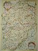
Imprint: Amsterdam, c.1645-[c.80]
400 x 535 mm., in early outline colour in excellent condition.
A fine example of Jan Jansson's map of the region to the north of Lyon in France, as published in the ;Atlas Novus'. Van der Krogt, P. (Atlantes) 4810:1A.
Stock number:8637.
|
|
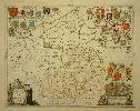
Imprint: Amsterdam, 1648-[51]
160 x 200 mm., with some light toning in the middle, otherwise in good condition.
In 1628 Jan Jansson published his own version of the Mercator-Hondius atlas in a smaller format and entitled it the Atlas Minor. There were no English county maps in the work, only five regional ones derived from Mercator and one of four British Islands. For the 1648 German edition the atlas was updated with an additional 36 new maps. Amongst these were eight maps of individual English counties. They are all the work of Pieter van den Keere who died c.1646 before they were published. It is curious that only these counties were issued as by then the full set had been published by Jansson in his folio atlas of 1646. Koeman II ME 203; Van der Krogt, P. (1967-70) 5300:352.1; Phillips (1909-) 5940.
Stock number:6339.
|
|
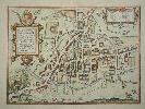
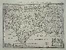
Imprint: Amsterdam, 1575-[c.1660]
325 x 445 mm., with very fine modern wash colour, a couple of filled worm holes in the bottom margin, well away from the image, otherwise in good condition.
A fabulous plan of Cambridge which was first published in Braun & Hogenbergs Civitates Orbis Terrarum in 1575. Jan Jansson later acquired the plate following the death of Abraham Hogenberg. Before he published it he removed the figures which were in the foreground and published it in his town books. The famous Colleges of the University town are depicted along with the castle built in 1068. A key identifies 19 locations. The Latin text to the verso describes the city. Koeman (1967-70) Ja15 no. 8.
Stock number:6267.
|
|
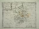
Imprint: Amsterdam, 1646
380 x 500 mm., in early outline colour, light even toning otherwise in good condition.
This map was originally published in Jan Jansson's 'Atlas Novus'. When compared to the rival Blaeu county maps those of Jansson always appear more decorative. Jansson was a very successful publisher who continued the business first founded by the great Gerard Mercator and subsequently taken over by the Hondius family. This particular map is of Cambridgeshire, the Latin text is taken from Camden's 'Britannia'. Skelton no. 34; Van der Krogt, P. (Atlantes) 5335:1.
Stock number:6183.
|
|