|
|
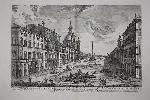
Imprint: Rome, 1763
390 x 530 mm., printed on thick paper in good condition.
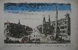
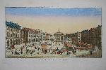
This fabulous view of the Piazza Navona in Rome is found in Jean Barbault's 'Les Plus Beaux Edifices de Rome Moderne'. Olschki states that the views of Barbault occupy an honourable place in the iconography of Rome. There are several figures in the image helping to bring it to life. I very recognisable image. Barbault studied in Paris before settling in Rome. He entered Rome at the time Piranesi was active and worked with him as well as becomming a rival. Barbault contributed figures to fourteen plates by Piranesi in volumes 2 and 3 of the 'Antichita Romane', 1754. There were not many collaborators. Seven years later Barbault's own collection of views on ancient Rome was published. In both this and the posthumously published 'Les Plus Beaux Edifices de Rome Moderne' (1763) from which this plate is drawn, Barbault drew on several views from Piranesi's earlier work. In the views of "modern" Rome, Barbault is, inevitably, close to Piranesi's contemporary views. Berlin Cat. 2712; Brunet I 546; Fowler 37; Olschki 16397.
Stock number:8625.
|
|
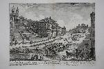
Imprint: Rome, 1763
390 x 530 mm., light waterstain at upper centre fold, not offensive, printed on thick paper in good condition.
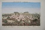
This fabulous view of the Spanish Steps in Rome is found in Jean Barbault's 'Les Plus Beaux Edifices de Rome Moderne'. Olschki states that the views of Barbault occupy an honourable place in the iconography of Rome. There are several figures in the image helping to bring it to life. Barbault studied in Paris before settling in Rome. He entered Rome at the time Piranesi was active and worked with him as well as becomming a rival. Barbault contributed figures to fourteen plates by Piranesi in volumes 2 and 3 of the 'Antichita Romane', 1754. There were not many collaborators. Seven years later Barbault's own collection of views on ancient Rome was published. In both this and the posthumously published 'Les Plus Beaux Edifices de Rome Moderne' (1763) from which this plate is drawn, Barbault drew on several views from Piranesi's earlier work. In the views of "modern" Rome, Barbault is, inevitably, close to Piranesi's contemporary views. Berlin Cat. 2712; Brunet I 546; Fowler 37; Olschki 16397.
Stock number:8626.
|
|
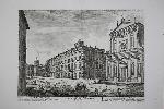
Imprint: Rome, 1763
390 x 530 mm., printed on thick paper in good condition.
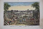
A view of the Palazzo Mattei in Rome is found in Jean Barbault's 'Les Plus Beaux Edifices de Rome Moderne'. Olschki states that the views of Barbault occupy an honourable place in the iconography of Rome. There are several figures in the image helping to bring it to life. Barbault studied in Paris before settling in Rome. He entered Rome at the time Piranesi was active and worked with him as well as becomming a rival. Barbault contributed figures to fourteen plates by Piranesi in volumes 2 and 3 of the 'Antichita Romane', 1754. There were not many collaborators. Seven years later Barbault's own collection of views on ancient Rome was published. In both this and the posthumously published 'Les Plus Beaux Edifices de Rome Moderne' (1763) from which this plate is drawn, Barbault drew on several views from Piranesi's earlier work. In the views of "modern" Rome, Barbault is, inevitably, close to Piranesi's contemporary views. Berlin Cat. 2712; Brunet I 546; Fowler 37; Olschki 16397.
Stock number:8651.
|
|
Imprint: London, 1797
680 x 490 mm., in good condition.
Sir John Barrow (1764-1848) was an English explorer and the Private Secretary to Lord Macartney whilst he was Ambassador to China. He would later become a founder member and vice-president to the Royal Geographical Society. The official account of Lord Macartney's voyage to the Qianlong Emperor of China 1792-94 was published as Sir George Staunton's 'An Authentic Account of an Embassy from the King of Great Britain to the Emperor of China'. Staunton (1737-1801) was a diplomat accompanying the voyage. This large chart displays the route from Canton to Nanjin (Nankin). Cordier Sinica 2381-3; Tooley's Dictionary.
Stock number:6291.
|
|
Imprint: London, 1950
Binding: Hardback 560 x 820 mm., printed colour, large folding map backed on linen within its publishers end boards complete with printed title, in very good condition.
John Bartholomew (1805-61) was the first of the family name to join a business founded in 1784. The period of the late nineteenth and early twentieth centuries represented the height of the companies influence. The main influence of growth in the business was John George Bartholomew (1831-93). He was the inventor of layer colouring, first introduced in his maps in 1888. One of the firms first significant productions was the Imperial Map of England and Wales derived from the Ordnance Survey. The map is a typically detailed one engraved on steel. It is drawn on a scale of half an inch to the mile. Beresiner British County Maps pp. 52-3.
Stock number:8095.
|
|
|
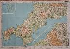
Imprint: Edinburgh, A. & C. Black, 1862
Binding: Hardback Publisher's green cloth box, gilt title to the spine, with 12 maps, each dissected and laid on contemporary linen, each approximately 490 x 500 mm., printed in full wash colour,
John Bartholomew (1805-61) was the first of the family name to join a business founded in 1784. The period of the late nineteenth and early twentieth centuries represented the height of the companies influence. The main influence of growth in the business was John George Bartholomew (1831-93). They were active until the Second World War. Adam Black (1784-1874) was a prominent politician also becoming MP for Edinburgh 1856-65. In 1827 he acquired the rights to the 'Encyclopaedia Britannica' which greatly stimulated his business. In 1840 they published 'Black's General Atlas of the World' which went through many editions. This excellent and finely engraved map was the most popular map of Scotland prior to the completion of the 1 inch Ordnance Survey about 1887 (Moir). The map was also issued as an atlas entitled Blacks New Atlas of Scotland. The title is on sheet number 6. It is drawn to the scale of four miles to an inch. Moir (1973) no. I p. 234; Worms & Baynton-Williams (2011).
Stock number:9979.
|
|
Imprint: London, 1747
360 x 480 mm., in good condition.
Plan of the siege of Turin by Prince Eugene on Sept. 7, 1706 here engraved by Isaac Basire. A small assumption is made in naming the engraver Isaac as the initial could be read as a 'J' for his son James who was not born until 1730. An explanation upper left identifies the key points of the map. From Nicolas Tindal's 'Continuation of Mr. Rapin's History of England'. Shirley, R.W. (BL Atlases) G.RAP 1a, no. 16.
Stock number:4645.
|
|
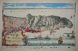
Imprint: London, 1751
390 x 600 mm., full wash colour, with a double fold as issued in the book. In good condition.
A beautifully engraved bird's-eye view of the Rock of Gibraltar by Isaac Basire. An explanation lower left identifies the key points. From Nicolas Tindal's 'Continuation of Mr. Rapin's History of England'. Shirley, R.W. (BL Atlases) G.RAP-1a, no. 7.
Stock number:8172.
|
|
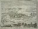
Imprint: London, 1747
360 x 480 mm. With a double fold as issued in the book. A fine example.
A beautifully engraved bird's-eye panoramic view of the town of Casal by Isaac Basire. It is depicted flanking the River Po. From Nicolas Tindal's 'Continuation of Mr. Rapin's History of England'. Shirley, R.W. (BL Atlases) G.RAP-1a, no. 17.
Stock number:4646.
|
|
Imprint: Paris, c.1760
280 x 420 mm., in early wash colour, light dirt to some of the margins otherwise in good condition.
This copperplate engraving is a fine example of the school of prints known loosely as 'Vue d'Optique'. They are most easily recognised by there consistent dimensions and style with notable blue wash skies. They are a form of perspective view which were popular during the eighteenth century in Europe. They were designed to be viewed through an optical device known as a 'zograscope' or 'optique', and were issued by many different publishers in various cities. This one is by Paul-Andre Basset who is part of an extensive family of print publishers in Paris. It is a fine bird's-eye view of the Piazza di San Giovanni in Laterano in Rome and is much the same today as it is in the view.
Stock number:7384.
|
|
Imprint: Paris, 4 May 1766
280 x 415 mm., early wash colour, with large deckled edge margins, in good condition.
This copperplate engraving is a fine example of the school of prints known loosely as 'Vue d'Optique'. They are most easily recognised by there consistent dimensions and style with notable blue wash skies. They are a form of perspective view which were popular during the eighteenth century in Europe. They were designed to be viewed through an optical device known as a 'zograscope' or 'optique', and were issued by many different publishers in various cities. This one is by Paul-Andre Basset who is part of an extensive family of print publishers in Paris. It is a fine bird's-eye view of the Foundling Hospital in London founded in 1741 by Thomas Coram. He was a philanthropic sea captain who set up the home as a place for children to be educated and housed who had been abandoned or deserted. The word hospital was used more openly in those days to refer to hospitality rather than today's meaning of more medical needs.
Stock number:7382.
|
|
Imprint: Paris, c.1760
280 x 405 mm., in early wash colour, light mark to the lower right corner of the margin, otherwise in good condition.
This copperplate engraving is a fine example of the school of prints known loosely as 'Vue d'Optique'. They are most easily recognised by there consistent dimensions and style with notable blue wash skies. They are a form of perspective view which were popular during the eighteenth century in Europe. They were designed to be viewed through an optical device known as a 'zograscope' or 'optique', and were issued by many different publishers in various cities. This one is by Paul-Andre Basset who is part of an extensive family of print publishers in Paris. It is a fine view of the approach to the royal palace of Versailles.
Stock number:8897.
|
|
Imprint: Paris, c.1760
235 x 415 mm., early wash colour, now binding marks, some minor edge tears in the very large margins, otherwise in good condition.
This copperplate engraving is a fine example of the school of prints known loosely as 'Vue d'Optique'. They are most easily recognised by there consistent dimensions and style with notable blue wash skies. They are a form of perspective view which were popular during the eighteenth century in Europe. They were designed to be viewed through an optical device known as a 'zograscope' or 'optique', and were issued by many different publishers in various cities. This one is by Paul-Andre Basset who is part of an extensive family of print publishers in Paris. It is a fine bird's-eye view of Covent Garden flower market. It began in a small manner in 1649 but following the Great Fire of London in 1666 which destroyed the markets in the City grew considerably. By the 1760s the market occupied much of the square.
Stock number:7381.
|
|
|
Imprint: Llanymynech, Shropshire, 1 August 1808
1395 x 1420 mm., early outline colour, cut, dissected and laid on linen, edged with blue silk which has frayed in places, some very light staining, with endpapers, contemporary marbled paper slipcase, with a printed label affixed to the upper cover, lightly worn, otherwise in good condition.
Robert Baugh (1750-1832) was a surveyor and engraver and produced John Evanâs large scale map of the six counties of North Wales along with its reduction in 1797. This map of Shropshire unusually extends into the neighbouring counties of Warwickshire, Staffordshire, and Montgomery. This also enabled a better illustration of the transport network access provided by the county. The map is dedicated to the Earl of Powis. This example is overlayed with outline colouring highlighting the railways later built. A very fine large inset view of the English Bridge in Shrewsbury completed in 1774. There is only the one edition of the map. Despite Baugh only producing two maps, the quality of his engraving here was rewarded with an award of 15 guineas by the Society of Arts. Kentish (1997) no. 49; Rodgers (1972) 388; Tooleyâs Dictionary; Worms & Baynton-Williams (2011).
Stock number:10156.
|
|
Imprint: London & Aylesbury, Watson & Hazell, 1870
Edition: First Edition Binding: Hardback Duodecimo (185 x 130 mm.), original publishers brown cloth, ornate gilt panelling, gilt titles to the front board and the spine. pp. vii, 127, with 8 plates from photographs. In good condition.
First edition, published to mark the opening of a new town hall. An early photographic book of the town and surroundings of Rickmansworth, Hertfordshire. The photographs are the work of H. V. Lemenager or Bushey.
Stock number:7378.
|
|
Imprint: London & Aylesbury, Watson & Hazell, 1870
Edition: First Edition Binding: Hardback Duodecimo (185 x 130 mm.), original publishers brown cloth, panellied, gilt titles to the spine. pp. vii, 127, in good condition.
First edition, published to mark the opening of a new town hall. An description of the town and surroundings of Rickmansworth, Hertfordshire.
Stock number:7379.
|
|
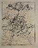
Imprint: Nuremberg, 1690
165 x 130 mm., in good condition.
The source of this town plan of Canterbury is the VERY RARE 'Das Neu-Geharnischte Gross-Britannien' published in Nuremberg by Johann C. Beer in 1690. It contained a series of town plans of the British Isles derived from various sources including Braun and Hogenberg, Speed, and even Merian. The map of Scotland in the atlas is engraved by Johann Baptist Homann who may have engraved the rest of the work also. Fordham 'Town Plans of the British Isles', in 'Map Collectors' Circle' no. 22 p. 10; Shirley BL I T.Beer 2a no. 18; Tooley (1999-2004).
Stock number:7223.
|
|
|
Imprint: Nuremberg, 1690
Quarto (205 x 165 mm.), full contemporary mottled calf, spine with raised bands and light wear, title label affixed. With engraved frontispiece, typographic title page, pp. (6), 1094, (18), with 3 folding general maps and 48 copper plates (23 town plans, 5 folding plates, and 20 further plates bound throughout). Final few leaves with both corners replaced incurring some loss towards the end, otherwise in good condition
A very rare description and history of the British Isles by Johann Christoph Beer (1638-1712). Issued shortly after the Glorious Revolution it celebrates William IIIâs accession to the throne. The title translates as follows; The newly armed Great Britain, that is: the true state and class of the three united kingdoms of Angels, Scotland and Ireland: in a complete description of their provinces, islands, cities, castles, fortresses, fruits, riches and regiments -Form, like no less of the most embarrassing state and war stories ... The first chapters provide detailed descriptions of important cities with accompanying plans. These are followed by chapters describing government and society up to the events under James II and William III.The work includes three large folding general maps and 23 town plans. The plans are drawn from those of Braun and Hogenberg, the county maps of John Speed or possibly more directly from the work of Rutger Hermannides in 1661. That of Dover is however drawn from Matheus Merian. The engraver of the map of Scotland is identified as Johann Baptist Homann, that of Ireland is the work of Cornelis Nicolas Schurtz. There has been some addition to many of the plates, although that of Cambridge is poorly engraved in reverse. To illustrate it further are several engraved portraits of important people in British history. A rare work, examples could only be traced through Copac at the British Library, Cambridge and Oxford Universities, the Guildhall Library and the London School of Economics. Provenance: acquired from Doreen Green c.2016; private English collection. Fordham (1965) p. 10; Shirley (1988) Anon 2; Shirley (2004) T.Beer 2a; Tooley (1999-2004).
Stock number:10139.
|
|
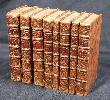
Imprint: Leiden, 1727
Duodecimo (165 x 100 mm.), 8 volumes, full contemporary marbled calf, gilt ruled, with ornate gilt ruled compartments with raised bands and gilt titles. With 243 plates and maps. With light wear to one or two spines, otherwise a good example.
The noted publisher Pierre Van der Aa dedicated this work on Great Britain to Queen Anne. In the ensuing years he published similar works of Italy, Spain and Portugal, Rome and Switzerland. Of the author James Beeverall nothing is known beyond this work. The text is drawn from the earlier works of Camden, Speed and Chamberlayne. First published in 1707 this second edition is greatly expanded and updated. Despite many images being derived from earlier published works they are by no means slavish copies. Many bear additional decoration of features. A beautiful English topographical work with numerous double page town views and country seats. Adams (1967) 20; Brunet (1860-80) 1735; Lowndes (1864) 146; Upcott (1968) p. xxiv.
Stock number:7613.
|
|
|
Imprint: Glasgow, 1834
Binding: Hardback Octavo (215 x 135 mm.), four volumes, contemporary half calf, cloth boards, ornate blind ruling, spines with raised bands, each decorated in gilt, gilt calf title and volume labels, marbled endpapers and marbled edged. With typographic title page, pp. (2), lxxii, 408; (2), 472; (2), 480; (2), 470, with 45 steel engraved maps comprising one large folding general map with old repairs to folds and rebound upside down, 42 of the English counties and north and south Wales, all side bound, minor foxing throughout as usual, otherwise in good condition.
In 1833-34 James Bell published 'A New and Comprehensive Gazetteer' in parts. Much of its source material was drawn from Samuel Lewisâ 'Topographical Dictionary of England'. In 1839 Lewis managed to obtain an injunction against Bell. The maps engraved for the work were later retained by Archibald Fullarton & Co. who utilised them in the 'Parliamentary Gazetteer' with new text. The Fullarton maps each contain a decorative vignette, the later issues bear railways. It is fascinating to see that only the earliest railways are present. None are found on the map of Middlesex but of course the Liverpool to Bolton, and Manchester, railways are present. Beresiner (1983) p. 102; Carroll (1996) 99; refer Chubb (1927) 445.
Stock number:10288.
|
|