|
|
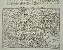
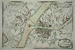
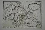
Imprint: Paris, 1575
120 x 170 mm., in fine condition.
A rare view of Zurich, Switzerland, from Francois de Belleforest's La Cosmographie Universelle published in Paris, 1575. The verso contains a further view of Lucerne. Pastoureau Belleforest I 2 no. 27; Shirley Atlases in the BL T.Belf 1a.
Stock number:4743.
|
|
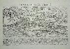
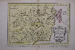
Imprint: Paris, 1575
230 x 250 mm., in fine condition.
A rare view of Geneva, Switzerland, from Francois de Belleforest's La Cosmographie Universelle published in Paris, 1575. The view is derived from that of Du Pinet. Pastoureau Belleforest I 2 no. 1; Shirley Atlases in the BL T.Belf 1a.
Stock number:4744.
|
|
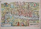
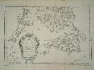
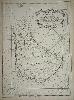
Imprint: Paris, 1575
320 x 485 mm., in fine old wash colour, with folds as issued, two very minor holes lower left side, small tear just into the left margin with old repair to verso, otherwise in good condition.
A rare woodblock map from Francois de Belleforestâs âLa Cosmographie Universelleâ published in 1575. The work contained 160 maps and plates derived mainly from either Sebastian Munster or George Braun and Frans Hogenberg. This particular desirable plan of London is drawn from the latter first published in 1572. Despite the Belleforest being listed as the THIRD PRINTED PLAN OF LONDON, it is in reality only the second available. There is no known complete example of the first surviving. Darlington & Howgego (1964) no. 3; Pastoureau (1984) p. 57 no. 4; Shirley (2004) T.Belf 1a.
Stock number:8389.
|
|
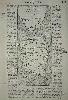
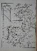
Imprint: Paris, 1575
235 x 100 mm., woodblock in fine condition.
An uncommon map from Belleforest's 'La Cosmographie Universelle' published in 1575. Pastoureau Belleforest I 2 no. 16.
Stock number:3157.
|
|
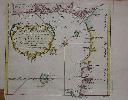
Imprint: Paris, 1764
21.5 x 33cm. In excellent condition, with some wash colour.
Folding plan of the city. Ex 'Petit Atlas Maritime'.
Stock number:3096.
|
|
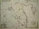
Imprint: Paris, 1753
60 x 81 cm., on lovely thick paper, some manuscript markings in left margin otherwise fine
A fine detailed sea chart of the Channel Islands published in the Depot de la Marine's 'Neptune Francois'. Pastoureau, M. Neptune Francais C.17.
Stock number:3014.
|
|
Imprint: Amsterdam, 1773
Binding: Hardback Quarto (280 x 225 mm.), contemporary quarter calf, marbled paper boards, light wear. With 9, (3) pp., typographic title page, Avertissement, Table Indicative and Liste des Cartes. With 40 copper plate engraved maps, some folding, all in very good full contemporary wash colour. With waterstain to bottom of first 2 blank endpapers and titlepage, otherwise in good condition.
A very nice atlas which covers the non-European world. All the maps are in very fine early wash colour. Provenance: Charles Deveraux manuscript ownership mark on front flyleaf and title page.
Stock number:7645.
|
|

Imprint: Paris, 1763
41 x 58.5 cm. Uncoloured chart, with a large inset of the island of Cayenne. Rhumb lines. Some creasing and marking to bottom margin.
Stock number:3306.
|
|
Imprint: Paris, 1752
21 x 30.5 cms., in good condition apart from a lower margin repair
From Prevost's "Histoire Générale des Voyages". Shirley BL G.Prev 1a.
Stock number:4013.
|
|
Imprint: Paris, 1758
55 x 40 cms., with a tear to the upper margin just into the image, otherwise okay.
A fine classic early large scaled map of Barbados. Campbell identifies two issues without giving priority but it is our understanding that this example is the earlier of the two. Campbell in TMCC 21, no.33, pl.14.
Stock number:4209.
|
|
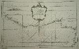
Imprint: Paris, 1750
550 x 890 mm., printed on fine thick paper. With two further folds to facilitate its placement in the atlas.
This beautifully engraved sea chart was issued undoubtedly to accompany the first main edition of Bellin's 'Hydrographie Francoise'. Bellin is most noted for his excellent contribution to marine cartography. This example focuses on the Gold Coast of Africa and extends southwards to take in the Island of St. Thomas on the equator. Shirley BL M.Bell 2a no. 23.
Stock number:4384.
|
|
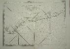
Imprint: Paris, 1750
420 x 590 mm., in good condition printed on thick paper.
This early chart by Nicolas Bellin details the Gold Coast of Africa. Bellin (1703-72) was Hydrographer in the French Dépôt de la Marine. With access to the latest navigational reports, he produced a great many maps and charts of excellent quality. This particular one appeared in the "Hydrographie Francoise". It is an early edition, without number, price or stamp of the Depot de la Marine. NMM 210 no. 129; Shirley Atlases in the BL M.Bell 2a no. 24.
Stock number:4526.
|
|
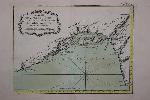
Imprint: Paris, 1764
390 x 305 mm., in good condition.
A finely engraved sea chart of the waters of the English Channel, the Bay of Biscay and the Spanish peninsula extending eastwards to Toulon. It is from Jacques Nicolas Bellin's greatest atlas, the 'Petit Atlas Maritime'. Phillips 638 & 3508; Shirley BL M. Bell 5a; Nordenskiold Collection 1; National Maritime Museum no. 211.
Stock number:7796.
|
|
Imprint: Paris, 1764
230 x 315 mm., in early wash colour and good condition.
An attractive map of the island of Hindoustan or northern India from Jacques Nicolas Bellin's greatest atlas, the 'Petit Atlas Maritime'. This copperplate engraved map shows the whole northern India with detail naming towns, cities and rivers. The rococo-style title cartouche bears a distance scale. Phillips 638 & 3508; Shirley BL M. Bell 5a; Nordenskiold Collection 1 no. 10; Maritime Museum no. 211.
Stock number:7412.
|
|
Imprint: The Hague, c.1765
200 x 280 mm., with full original wash colour in good condition.
A map of the Pacific coast of Tartary displaying Sakhalin Island. It was published in the very rare Dutch edition of Abbe Antoine Francois Prevost's (1697-1763) 'Histoire Generale des Voyages'. Refer Shirley BL G.Prev 1a.
Stock number:8606.
|
|
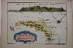
Imprint: Paris, 1764
230 x 300 mm., in early wash colour and good condition.
A detailed map of part of the Gold Coast of Africa now displaying the coast of present day Nigeria in the east to Ghana in the west at the mouth of the River Volta. Lagos itself is identified by 'Cap Lagos'. It is from Jacques Nicolas Bellin's greatest atlas, the 'Petit Atlas Maritime'. Phillips 638 & 3508; Shirley BL M. Bell 5a; Nordenskiold Collection 1 no. 10; Maritime Museum no. 211.
Stock number:8609.
|
|
Imprint: Paris, 1764
210 x 350 mm., in early wash colour and good condition.
A detailed map of part of the Gold Coast of Africa now displaying the coast of present day eastern Nigeria and the town of Calabar. The work is based upon the 1699 slave voyage of James Barbot and John Grazilhier to the region. Sent by the French King they were instructed to acquire slaves. It is from Jacques Nicolas Bellin's greatest atlas, the 'Petit Atlas Maritime'. Phillips 638 & 3508; Shirley BL M. Bell 5a; Nordenskiold Collection 1 no. 10; Maritime Museum no. 211.
Stock number:8611.
|
|
Imprint: Paris, c.1765
265 x 280 mm., with full modern wash colour, folded as issued, in good condition.
A map of the coast of west Aftica from the equator north to the coast of Guinea. The island of Saint Thomas is prominently shown offshire. It was published in Abbe Antoine Francois Prevost's (1697-1763) 'Histoire Generale des Voyages'. Shirley BL G.Prev 1a.
Stock number:9124.
|
|
Imprint: Paris, 1758
200 x 280 mm., with full modern wash colour in good condition.
A map of Juan Fernandes Island to the west of Santiago, Chile in the Pacific Ocean. The island is most famous for being the home of Alexander Selkirk for four years which was it is believed the inspiration for the novel Robinson Crusoe. Indeed the island is now named after the character. It was published in Abbe Antoine Francois Prevost's (1697-1763) 'Histoire Generale des Voyages'. Shirley BL G.Prev 1a.
Stock number:8605.
|
|
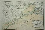
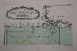
Imprint: Paris, Plan de Bayonne, 1764
22 x 32.5cm. In excellent condition, with some wash colour.
Detailed section of coastline, Narbonne featured. Ex 'Petit Atlas Maritime'.
Stock number:3097.
|
|