|
|
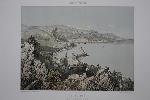
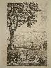
Imprint: Paris, Henri Charpentier, 1864
270 x 320 mm., tinted lithograph in good condition.
This attractive view of Villefranche and port highlights how undeveloped the coastline was at the time. It is from Felix Benoist's work entitled 'Nice et Savoie, site pittoresque ...'. Benoist (1818-96) was born in Saumur and became an artist whose works were often made into lithographs. Benezit.
Stock number:8757.
|
|

Imprint: Zurich, 2016
Edition: First Edition
Stock number:12345.
|
|
Imprint: Zurich, 2100
Stock number:8805_156.
|
|
Imprint: Zurich, 1566
Edition: First Edition
Stock number:8805_large.
|
|
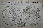
Imprint: London, William Berry at ye Sign of the Globe between Charing Cross and Whitehall, 1680
575 x 885 mm., in early outline colour, some professional repair to edge tears and reinforcement to lower corners, not affecting the image, with the accompanying page of geographical tables, otherwise in good condition.
A fine rare English double-hemispheric seventeenth century world map. In September 1678 Robert Morden (fl. 1669, d. 1703) and William Berry (1639-1718) petitioned the crown for a licence to do all general and particular maps of the several parts of the world according to an alphabeticall manner. Mordens connection with what appears to be the birth of the folio atlas is not heard of again. Berry began publishing a series of large two sheet maps with a group of the world and continents advertised in the London Gazette, from 1-5 July 1680. The world is also announced in the Term Catalogues for the summer of that year. This only mentions the world map, which would undoubtedly have been finished first, and the continents would have followed. Berry did not advertise his next two sheet map, that of England, until February 1682.Through the 1680s Berry published nearly forty large maps of parts of the world, sufficient to cover it all. From the late 1680s he clearly offered them bound together as a collection of maps as a handful of examples are known, but this was clearly not the intention for the maps, as none have borne any title page. Examples are known in the British Library, the Library of Congress and the National Maritime Museum, Greenwich, all bearing either thirty-seven or thirty-eight maps. An example has been noted for sale by Maggs Brothers, which bore sixty-nine maps, the balance being made up of contemporary English maps by other cartographers dating the atlas to c.1704, and two further offered at Christies, auctions in London in the 1980s (Burden). Cartographically the world map is drawn directly from that of Alexis-Hubert Jaillot, 1674. Jaillots map was, in turn, derived from Nicolas Sansons geography, who is here recognised in the running title above, Described by Sanson Corrected and amended By William Berry. Sanson had far more of a reputation in cartographic circles than Jaillot so it is natural that Berry would use his name. These amendments include the patriotically named islands off Tierra del Fuego and New Albion placed in California. New Guinea is distinctly an island and there is no southern continent. An ornate cartouche lower centre includes an effusive dedication to Charles II. Armitage (2012) pp. 41 & 99-100; Burden (1996-2007) 532; Phillips (1909-) 3442; Shirley (1984) 501; Shirley (2004) T.Berr 1a; Tyacke (1973) p. 76; Tyacke (1978) no. 100 & pp. 109-10.
Stock number:7758.
|
|
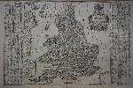
Imprint: London, William Berry at the Sign of the Globe between Charing Cross and White Hall, 1680
590 x 880 mm., in two sheets joined, early outline colour, some professional repair to lower centrefold not affecting the image, with one or two small surface marks none offensive, trimmed just touching the upper left corner but generally with good margins all round, otherwise in good condition.
A fine rare English seventeenth century road map. In September 1678 Robert Morden (fl. 1669, d. 1703) and William Berry (1639-1718) petitioned the crown for a licence to do all general and particular maps of the several parts of the world according to an alphabeticall manner. Mordens connection with what appears to be the birth of the folio atlas is not heard of again. Berry began publishing a series of large two sheet maps with a group of the world and continents advertised in the London Gazette, from 1-5 July 1680. The world is also announced in the Term Catalogues for the summer of that year. This only mentions the world map, which would undoubtedly have been finished first, and the continents would have followed. Berry did not advertise his next two sheet map, that of England and Berry's first, until February 1682.Through the 1680s Berry published nearly forty large maps of parts of the world, sufficient to cover it all. From the late 1680s he clearly offered them bound together as a collection of maps as a handful of examples are known, but this was clearly not the intention for the maps, as none have borne any title page. Examples are known in the British Library, the Library of Congress and the National Maritime Museum, Greenwich, all bearing either thirty-seven or thirty-eight maps. An example has been noted for sale by Maggs Brothers, which bore sixty-nine maps, the balance being made up of contemporary English maps by other cartographers dating the atlas to c.1704, and two further offered at Christies auctions in London in the 1980s (Burden). This second map of England by Berry was announced in the 'Term Catalogues' for November 1685 and dedicated to James II who became King on 6 February 1685. He was deposed in the Glorious Revolution of 1688 by William III and for the second state offered here the dedication is altered to reflect the new King. The map is derived from the large wall map of the roads by John Adams published in 1677. It features the distances between towns within circles and by using straight lines. The inspiration for Adams' original work was undoubtedly the success of John Ogilby's book of roads entitled 'Britannia' published in 1675. Provenance: private English collection since the 1970s when it was acquired for £9! Burden (1996-2007) 532; Phillips (1909-) 3442; Shirley (1988) Berry 2.ii; Shirley (2004) T.Berr 1a no. 8; Tyacke (1973) p. 76; Tyacke (1978) no. 100 & pp. 109-10.
Stock number:8243.
|
|
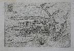
Imprint: Venice, 1599
120 x 175 mm., printed slightly off square otherwise in good condition.
Pietro Bertelli (fl.1594-1616) was a member of the extensive family of engravers, publishers and mapsellers of the same name largely known to work in Venice. In 1599 Pietro published a series of town plans under the title 'Theatrum Urbium Italicarum' which were mainly bird's-eye views. Ganado describes this plate "This bird's-eye view of the harbour shows on Mount Sceberras what has been described as the Lanci proposal for the new city. It is cut off from Fort St Elmo and the land front is in line with Senglea. The map was based on the map by Francesco Valegio." The new city of 'Valeta' is identified. Cremonini (1991) no. 9 (12); Ganado (2003) no. 86; Mason 'Maps of Malta in the Order of St. John' no. 20; refer Shirley (2004) T.Ber 2a no. 13.
Stock number:7352.
|
|
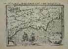
Imprint: Amsterdam, 1616
100 x 135 mm., , minor tear repaired lower margin, not effecting the image, otherwise fine.
This map of central Africa focuses on the land of the legendary Christian King, Prester John. The Nile River flows from two large lakes. Shirley BL T.Bert 2a.
Stock number:4634.
|
|
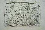
Imprint: Amsterdam, 1616
10 x 14 cms., with early wash colour to the sea
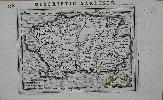
This attractive little map of Catalonia and Aragon was published in Amsterdam by Petrus Bertius. The work it comes from is a revised edition of Barent Langenes' "Caert Thresoor". The maps were all newly engraved by Jodocus Hondius. Van der Krogt, P. (Atlantes) 6281:342; Shirley "Atlases in the BL" T.Bert 2a.
Stock number:4049.
|
|
Imprint: Amsterdam, 1616
Inscription: Signed, Inscribed Or Annotated 100 x 135 mm., in fine condition.
This attractive little map of the world according to the Egyptian geographer Ptolemy was published in Amsterdam by Petrus Bertius. It displays a ptolemaic geography with climatic zones identified. The work it comes from is a revised edition of Barent Langenes' 'Caert Thresoor' entitled 'Tabularum Geographicarum Libri ...' The maps were all newly engraved by Jodocus Hondius, this example is signed by him and has Latin text on the verso. King (2nd ed.) pp. 96-99; Van der Krogt, P. (Atlantes) 6281:342; Shirley 'Atlases in the BL' T.Bert 2a.
Stock number:8602.
|
|
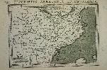
Imprint: Amsterdam, 1616
100 x 140 mm., a fine dark impression.
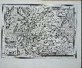
This attractive little map of Granada and Murcia was published in Amsterdam by Petrus Bertius. The work it comes from is a revised edition of Barent Langenes' "Caert Thresoor". The maps were all newly engraved by Jodocus Hondius. It focuses on the south of Spain and bears two galleons offshore. Van der Krogt, P. (Atlantes) 6281:342; Shirley "Atlases in the BL" T.Bert 2a.
Stock number:4050.
|
|

Imprint: Amsterdam, 1598-[1600]
90 x 130 mm., in very good condition.
In 1598 Barent Langenes published in Middleburgh a miniature atlas to rival that of Abraham Ortelius. The maps were largely engraved by Jodocus Hondius and his brother-in-law Pieter van den Keere. A very fine early map of the the island of Madagascar in the Indian Ocean. With additional letterpress title above map 'Descriptio Ins. Madagascar'. Engraved by Petrus Kaerius with Latin text on verso. Van der Krogt, P. (Atlantes) 8320; Shirley 'Atlases in the BL' T.Lan 1a.
Stock number:4969.
|
|
|
Imprint: 1616
Edition: First Edition 95 x 130 mm., in full wash colour, in good condition.
An early map of Indo-China and the Malay Peninsula orientated with north to the right. It was published in a revised and expanded edition by Petrus Bertius of Barent Langenes' 'Caert Thresoor', here entitled 'Tabularum Geographicarum Contractarum'. The maps were all newly engraved by Jodocus Hondius. This is an example of the first edition from 1616 with Latin text. Bertius was the librarian of the University of Leyden and related to Hondius by marriage. The maps were slightly larger in size and the book was dedicated to King Louis XIII of France. Several place names are found from from present day Vietnam through Cambodia, Siam (Thailand) and the peninsula of Malacca. The map is finished with longitude and latitude scales in the border. Koeman Lan 11A 196; Van der Krogt, P. (Atlantes) 8495:342; Shirley BL T.Bert 2a.
Stock number:9890.
|
|
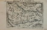
Imprint: Amsterdam, 1616
105 x 135 mm., with Latin text to the verso, in good condition.
A very fine early map of the southern tip of the Indian peninsula with a nearby Ceylon. Narsinga was the region of southern India otherwise known as the Hindu Vijayanagara Empire. The work it comes from is a revised edition of Barent Langenes' 'Caert Thresoor' of 1598 and was first published in 1616. The maps were all newly engraved by Jodocus Hondius, this example has Latin text on the verso. Koeman Lan 11A; Van der Krogt (Vol. III) no. 8335:342; Shirley 'Atlases in the BL' T.Bert 2a.
Stock number:8141.
|
|
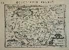
Imprint: Amsterdam, 1616
100 x 130 mm., in good condition.
This map of Persia or modern day Iran appears in the 1616 newly revised, enlarged and improved issue of Petrus Bertius' "Thresor des Cartes". The maps were in the main newly engraved by Jodocus Hondius. Shirley BL T.Bert 2a.; Van der Krogt, P. (Atlantes) 8200:342.
Stock number:4952.
|
|
Imprint: 1616
95 x 130 mm., in good condition.
This attractive little map of the Island of Sardinia was published in Amsterdam by Petrus Bertius. The work it comes from is a revised edition of Barent Langenes' 'Caert Thresoor' first published in 1616. The maps were all newly engraved by Jodocus Hondius, this example has Latin text on the verso. Koeman Lan 11A no. 147; Shirley 'Atlases in the BL' T.Bert 2a.
Stock number:7889.
|
|
Imprint: Amsterdam, 1639
9.5 x 13cm. Uncoloured. Folds.
ex 'The Abridgement of Camden's Britannia'
Stock number:2645.
|
|
Imprint: Eichstatt, 1613
Edition: First Edition 510 x 400 mm., in FULL EARLY WASH COLOUR, excellent condition.
Basilius Beslers 'Hortus Eystettensis' is considered to be one of the most important and beautiful florilegia ever published. The book which was the largest ever published at the time, was commissioned by Prince-Bishop Johann Conrad von Gemmingen in 1606 whose castle overlooked the town of Eichstatt to the south of Nuremberg. His garden was begun by Joachim Camerarius the younger (1534-98) but was completed by Basilius Besler. Besler was a pharmacist from Nuremberg who had his own renowned garden. Besler used the services of his younger brother Hieronymus and Ludwig Jungermann, a teacher in natural history at the University of Altdorf. The project was to be a vast catalogue and it is believed that Hieronymus Besler helped him write the Latin text, while Jungermann prepared the botanical descriptions. In the dedication Besler identifies himself as the author of many of the original drawings which are conserved today in the library of the University of Erlangen. The engraving of the 378 plates however took many years and was the work of others. The Hortus Eystettensis was published in 1613, unfortunately just one year after Gemmingen died. Coloured examples sold for 500 fl., ten times that of a black and white version! The full plate sunflower offered here was described in the Oak Spring Flora as having an undeniable expressive power. Indeed it is hard to think of a historical botanical engraving which is as well-known and has such impact. The plate appears as the first in the section on summer in the book and as such is the very symbol of long warm days. This example is remarkable in not only being the most famous botanical engraving in the first edition of 1613 but also being in FULL EARLY WASH COLOUR. This example has been authenticated by Nicolas Barker whose book studied only the early coloured examples extant. He located approximately twenty-two examples of the book in early colour, considerably more than previously thought. The book goes into extensive detail about pigments used, even identifying some of the colourists by name. It also completely re-wrote the previous misconceptions about the differing editions. His comments on this example were 'In sum, I believe these plates to come from a copy coloured according the original exemplar (that is, before the use of written instructions), probably before the middle of the 17th century.' Provenance: private German collection since the 1950s; private English collection since 1990. Barker Hortus Eystettensis. The Bishops Garden and Beslers Magnificent Book; Barker, Nicolas, private correspondence; Hunt 430; Nissen 158; Pritzel 745; Stafleu & Cowan 497; Tomasi Oak Spring Flora pp. 52-7.
Stock number:7990.
|
|
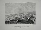
Imprint: Paris, C.1840
235 x 275 mm., in good condition.
A fine lithograph of the city of Valparaiso, Chile. It is lithographed by Bernard et Frey and numbered plate 18 upper right.
Stock number:8200.
|
|
Imprint: London, 1743-[96]
240 x 145 mm., light foxing lower left margin, otherwise in good condition.
First published in George Bickham's fully engraved 'British Monarchy' c.1743. A little known later edition by George Bickham Junior was published by Laurie and Whittle in 1796 under the title 'A Curious Antique Collection of Birds-eye Views of the Several Counties'. Of extreme rarity in either edition, the first is known in only 7 examples. The maps are highly collected for their distinctiveness. This is an example of the map of the county of Buckinghamshire. Wyatt p. 17; Hodson 218; Lyon 'A Bird's-eye View of the Bickhams' in 'The Map Collector' no. 2 pp. 30-3.
Stock number:6330.
|
|